
1HappyHiker
Well-known member
Background:
The closest I ever got to Mt. Davis was a few years ago when I did Mt. Isolation as part of completing the NH4K list. You’ve gotta realize that I’m a hard-core day-trip hiker who relishes a hot shower and sleeping in his own bed at the end of a day hiking in the Whites. So, every time I’ve thought about going to Davis, the round-trip mileage has always dissuaded me from attempting it as a day-trip.
I’ve often looked at trail maps and have seen that, as the crow flies, Mt. Davis is a very short distance due west from the Dry River Trail. Several months ago I began to think about the possibility of cutting Mt. Davis down to size by bushwhacking from the Dry River Trail to a point on the Davis Path just a bit south of the spur trail to Mt. Davis. The whack plus the on-trail hiking distance worked out to a round-trip journey of just over 10 miles . . . a very doable day-hike!
Also, I talked with a hiker who had done my proposed trek, and he indicated that the whack was relatively easy. However, he cautioned that his whack was prior to the ’98 ice storm and there was a possibility that I could encounter a jumble of blowdowns on the way up IF the ice storm had played havoc there.
So, after laying out a route and gathering background information from a fellow-whacker, I eagerly awaited a day when I felt that the Dry River might be forded SAFELY! Yesterday was the big day!
The Journey:
I arrived at the crossing point of the Dry River about 45 minutes from leaving the trailhead on Route 302. I gazed longingly at the storm-damaged suspension bridge. From all outward appearances, it’s difficult to understand what’s wrong with it, and therefore it’s so tempting to use it rather than fording the river.
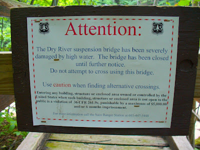
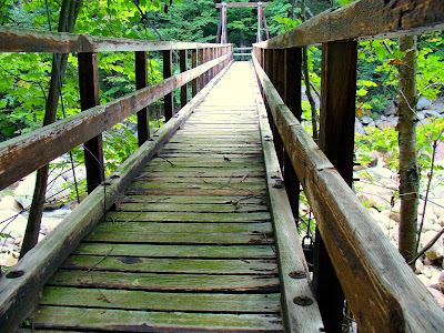
However, not having $5,000 to blow on a fine, nor wanting to spend 6 months in jail, nor wanting to “fall” victim to possible personal injury . . . I did NOT use the bridge to cross the river.
After the time-consuming process of fording the river, it took just under an hour to arrive at the point to begin the westward whack from the Dry River Trail to the Davis Path. The whack began from the back of a tentsite about 0.6 miles from the Mt. Clinton Trail junction. Using TOPO software, I calculated that the whacking distance between the Dry River Trail and the Davis Path should be about 1.1 miles. It took just under 2 hours to whack this distance. Fortunately, I did not encounter massive blowdowns from the ’98 ice-storm, but did encounter lots of nasty hobble-bush.
After arriving at the Davis Path, it took about 20 minutes for the short trek to the summit of Mt. Davis.
THE BOTTOM LINE TO ALL THIS: I was sitting atop Mt. Davis just a tad over 4 hours from leaving the Route 302 trailhead!! Take that Mt. Davis . . . you’ve been cut down to size!! (And, if the suspension bridge was useable, the total time to the Davis summit might even be well under 4 hours.)
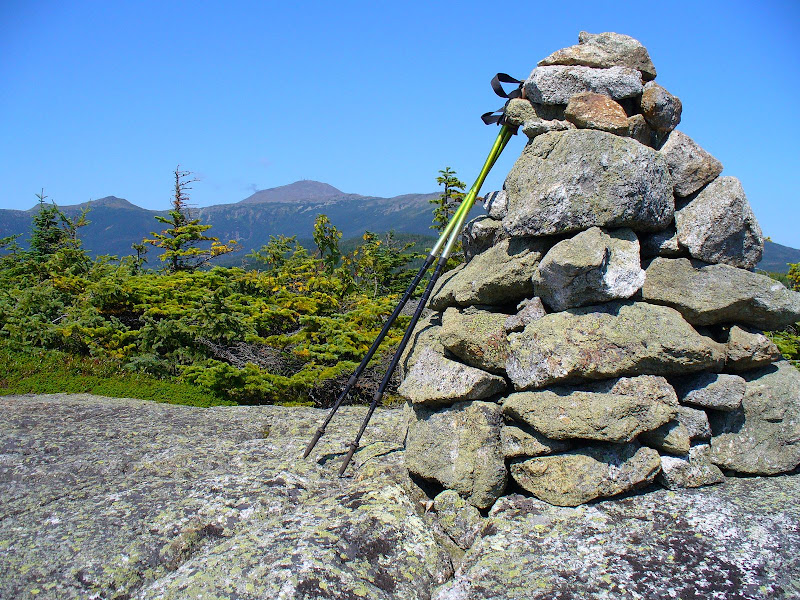
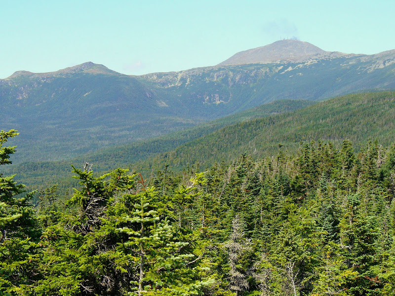
Some More Summit Photos & Map:
The 360 degree views from Mt. Davis are impressive!
I won’t bore you with tons of photos, but here are two.
This snapshot is looking at (3 guesses, and the first 2 don’t count) . . . yes Mt. Washington!
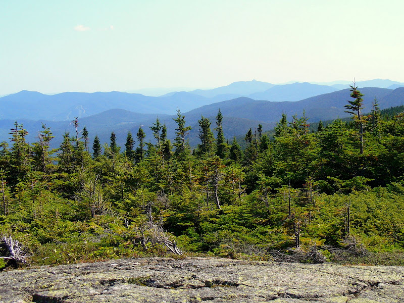
This photo below sort of encapsulates the myriad of “purple mountain majesties” views from Mt. Davis.
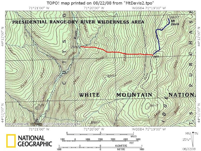
And lastly, the red line on the map below shows the bushwhack portion of my trek.
1HappyHiker
The closest I ever got to Mt. Davis was a few years ago when I did Mt. Isolation as part of completing the NH4K list. You’ve gotta realize that I’m a hard-core day-trip hiker who relishes a hot shower and sleeping in his own bed at the end of a day hiking in the Whites. So, every time I’ve thought about going to Davis, the round-trip mileage has always dissuaded me from attempting it as a day-trip.
I’ve often looked at trail maps and have seen that, as the crow flies, Mt. Davis is a very short distance due west from the Dry River Trail. Several months ago I began to think about the possibility of cutting Mt. Davis down to size by bushwhacking from the Dry River Trail to a point on the Davis Path just a bit south of the spur trail to Mt. Davis. The whack plus the on-trail hiking distance worked out to a round-trip journey of just over 10 miles . . . a very doable day-hike!
Also, I talked with a hiker who had done my proposed trek, and he indicated that the whack was relatively easy. However, he cautioned that his whack was prior to the ’98 ice storm and there was a possibility that I could encounter a jumble of blowdowns on the way up IF the ice storm had played havoc there.
So, after laying out a route and gathering background information from a fellow-whacker, I eagerly awaited a day when I felt that the Dry River might be forded SAFELY! Yesterday was the big day!
The Journey:
I arrived at the crossing point of the Dry River about 45 minutes from leaving the trailhead on Route 302. I gazed longingly at the storm-damaged suspension bridge. From all outward appearances, it’s difficult to understand what’s wrong with it, and therefore it’s so tempting to use it rather than fording the river.
However, not having $5,000 to blow on a fine, nor wanting to spend 6 months in jail, nor wanting to “fall” victim to possible personal injury . . . I did NOT use the bridge to cross the river.
After the time-consuming process of fording the river, it took just under an hour to arrive at the point to begin the westward whack from the Dry River Trail to the Davis Path. The whack began from the back of a tentsite about 0.6 miles from the Mt. Clinton Trail junction. Using TOPO software, I calculated that the whacking distance between the Dry River Trail and the Davis Path should be about 1.1 miles. It took just under 2 hours to whack this distance. Fortunately, I did not encounter massive blowdowns from the ’98 ice-storm, but did encounter lots of nasty hobble-bush.
After arriving at the Davis Path, it took about 20 minutes for the short trek to the summit of Mt. Davis.
THE BOTTOM LINE TO ALL THIS: I was sitting atop Mt. Davis just a tad over 4 hours from leaving the Route 302 trailhead!! Take that Mt. Davis . . . you’ve been cut down to size!! (And, if the suspension bridge was useable, the total time to the Davis summit might even be well under 4 hours.)
Some More Summit Photos & Map:
The 360 degree views from Mt. Davis are impressive!
I won’t bore you with tons of photos, but here are two.
This snapshot is looking at (3 guesses, and the first 2 don’t count) . . . yes Mt. Washington!
This photo below sort of encapsulates the myriad of “purple mountain majesties” views from Mt. Davis.
And lastly, the red line on the map below shows the bushwhack portion of my trek.
1HappyHiker
Last edited:
