Exploring the Trailless “Backside” of Tecumseh (17-Feb-2009)

vftt.org

Help Support vftt.org:

This site may earn a commission from merchant affiliate links, including eBay, Amazon, and others.

1HappyHiker

Well-known member
Joined
Jan 18, 2007
Messages
1,973
Reaction score
405
Location
Bethlehem, NH
On a fine winter day, my hiking partner Steve & I did some bushwhack exploration of the Haselton Brook area (the southwest side of Mt. Tecumseh, i.e. its trailless “backside”.)

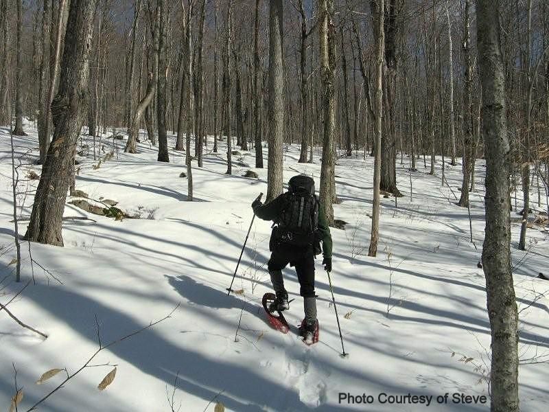
Conditions were near perfect for our bushwhack adventure: firm, sun-baked, consolidated snow; mid 20’s air temperature; very little wind; deep-blue sky. And, added to all that, there were large stretches of hardwoods so open that it almost resembled well-groomed parkland. There were some short-lived sections of thick stuff encountered en route to the ledges along the Bald Mountain ridge, but this is often the case when approaching ledgy areas.

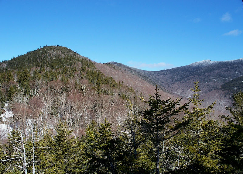
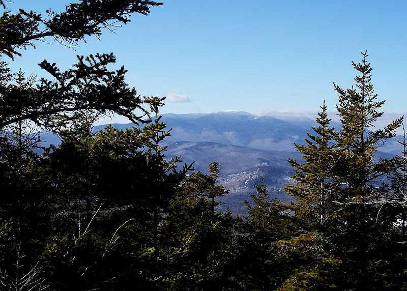
From the Bald Mountain ledges, there were excellent views of the “backside” of Tecumseh. Also, there were some good westerly views toward Moosilauke. And, if there had not been a lingering cloud cover to the north, the views toward the Franconia Range would have been excellent.

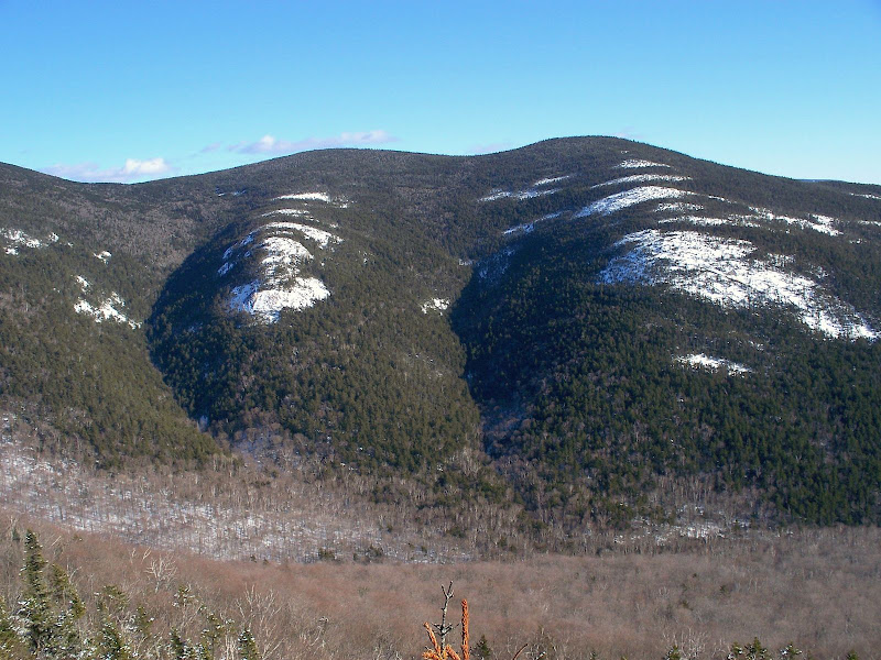
Additionally, there were up-close views of the ledgy lumps that line a portion of the eastern valley wall, directly opposite Bald Mountain. In the Sweetser guidebook from the late 1800s, one of these lumps was called “Spring Mountain”. There was once a road leading to a mineral spring-house in this vicinity where water from two nearby mineral springs was collected.

Here are a few photos:

BACKSIDE OF TECUMSEH
100_0997.JPG

LEDGY LUMPS OPPOSITE BALD MOUNTAIN
100_1004.JPG

WESTERLY VIEW TOWARD MOOSILAUKE
100_1002.JPG

OUR WHACK THROUGH "HARDWOOD HEAVEN"
Hardwoods.JPG

1HappyHiker
 
Last edited:
Nice job once again, John! I've found that area to be compelling when looking at it from Tecumseh, West Tecumseh, and Welch-Dickey. Great photos!
 
I've been wanting to do a bushwhack from Dickey to Tecumseh for sometime now. I just might do it this year come spring.
 
I've been wanting to do a bushwhack from Dickey to Tecumseh for sometime now. I just might do it this year come spring.
Going across Green Mtn too I presume? That'd be pretty neat.

Nice report John, love hearing of off the beaten path trips like this.
 
. . . here's a link to a posting by dms of a BW traverse they did. I think it's better to have gravity on your side ... better to go from Tecumseh to Welch-Dickey.

http://www.vftt.org/forums/showthread.php?t=18235&highlight=west+Tecumseh
Ray, thank you for posting the link posted by DMS about a hike in this general area in August 2007. After reading the description of that hike, I recalled Steve Smith mentioning that there were once several routes to Tecumseh from its “backside”.

The attachment below is an excerpt from page 325 of the old Sweetzer guide from the 1880s. Note that in the second paragraph, the author lists 3 routes for ascending Tecumseh from the west. One of these routes mentions going over Fisher and Green Mtns. After all these years, wouldn’t it be remarkable if the “secret trail” (mentioned in your posted link) might be a remnant of an old route to Tecumseh?
 
Last edited:
I have heard of climbing Tecumseh from Johnson Brook, but never done it myself

The advantage I see of starting from Dickey is that I know where the trail starts on that end but not from Tecumseh

I was going to do the D-T traverse with Periwinkle, but she was off to the Islands before it happened
 
I’ve hiked to the large cairn on the northern slab of Dickey a few times and from there it looks like a straight shot to follow the ridge up to Green. Once the snowpack melts enough I would like to give it a shot. I did hike from the W/D parking lot to Tripoli Rd. a few years ago following an old bike path and logging roads that dumped me out on Tripoli just west of the East Pond Trail.
 
I've found an old herd path (secret trail?) from Dickey that will bring you to an open area below the climb up to Green Mt.

From the summit of Dickey hike towards Green (maybe you guys call this Fischer but it's the peak I see on the way toward Tecumseh) on the exposed rock slabs following small cairns along the way. As the exposed rock slab slants downward you enter the forest. (Basically just walk on the exposed rock slab as long as you can until you have no choice but to enter the forest. But stay on the left side of this exposed rock slab.)

When you enter the forest you won't see a herd path just yet but continue onward in the direction of Green for about 100 yards. You will see what appears to be a very small open area through the trees so walk in that direction. You will reach a small open area where you find yourself standing on some more exposed rock.

Hike 12 o'clock for about 25 yards and then 10 o'clock for about 50 yards. You will then see this herd path/secret trail.

It's awesome and easy to follow. There are small cairns along the way that seems to have been placed there a long time ago. It lasts for 1/2 mile (maybe more) but will bring you to an exposed area of rock with great views of Sandwich Mountain. You will be at the base of Fischer/Green.

From there hike 10 o'clock at first skirting a wet area but you will find another trail that seems to continue further. I ran out of time and could not continue but this might bring you up to Fischer/Green. At least it appears to be going in that general direction.

One of these days I'm going to have to give myself the extra time to explore this further.
 
Top