Perhaps an Old Sawmill Near Southern End of Tunnel Brook Trail??

vftt.org

Help Support vftt.org:

This site may earn a commission from merchant affiliate links, including eBay, Amazon, and others.

1HappyHiker

Well-known member
Joined
Jan 18, 2007
Messages
1,973
Reaction score
405
Location
Bethlehem, NH
During one of my recent meanderings, I came across the ruins shown in the photos below. I presume this was a sawmill at one time?? These remains are located near the southern terminus of the Tunnel Brook Trail but on the opposite side of the brook (east side). Just curious if anyone has any information about this structure, such as the timeframe when it was in operation, etc.

I seem to recall this question being addressed once before on this Forum, but can't locate a thread for it.

Thanks!

P1050457.JPG


P1050454.JPG
 
I haven't seen that! Good find! Looks pretty intact! The cement footings suggest (to me) it's not more than 100 yrs old-- my guess would be the peak logging timeframe - first quarter or half of 20th century... but I'm no archeologist :)

Cool
 
Need more info

John

The foundation doesn't appear to be big enough to be a sawmill. A sawmill would have very large area to enable handling of long saw logs etc. Also very many footings to support large floor area and stuff to keep the logs and boards staright and true. The wheel could be grinding wheel or could be a flywheel or more likely a big wheel to attach belts for power transfer to somewhere else in the building. Some distance shots that show overall footprint of the foundations would help. Area to side of flywheel looks like it might have been spot where a big engine was parked that perhaps drove the wheel.

See photo below I took of ruins of sawmill at Livermore on Sawyer River. See long row of concrete footings with anchor bolts for structural flooring. Granted this was a big sawmill. What you found may have been more of a portable sawmill set up for short time only.

IMG3045-L.jpg


I hope you took some photos.

Ray
 
Perhaps it is an ancillary structure related to the old (circa 1909) Glencliff State Sanitarium (now the Glencliff Home)?

You said it was not too far from that (southern end of trail, east side of Slide Brook), correct?
 
Nice find. If it wasnt on national forest land, I expect someone would grab it for the flywheel as its quite an impressive piece. Most of the temporary sawmills I have seen didnt require such extensive concrete and structure, They were usually skid mounted and set in place on the ground and shimmed up as needed. Whatever the plant was in the picture, it was designed to be there for awhile.

The flange and offset increaser that runs out of the wall in the background at 90 degrees to the flywheel shaft is the type of set up used on pump discharges and suctions of pumps. The line is also offset vertically from the centerline of the flywheel shaft. These clues point to possbily a high speed pump or a high pressure hydroelectric turbine. Here is a link to a photo of a modern equivalent.

http://www.google.com/imgres?hl=en&...45&tbnw=145&start=12&ndsp=24&ved=0CMcBEK0DMBk

A centrifugal pump and a centrifugal turbine are basically the same device used differently, a pump converts rotation of the center shaft into pumping water, a turbine converts the movement of flowing water into rotation of the center shaft.

It there was a large water source uphill from the site with possibly a breached dam, the building could be a generating plant. The flywheel would have a leather belt used to drive an electrical generator. The generator would have been mounted above the flywheel to keep it up above the water in case of leaks. Given that the NH rest home complex is somewhere along the south end of Tunnel Brook Road, this could have been a power plant for the facility long before the electrical grid reached it.

Arguably it also could be a water supply for the same facility assuming that there was an upstream dam or deep pool to draw from. The rough sizing reminds me of some of the fire pumps I have run into over the years at papermills and boiler houses. They are designed to supply high pressure water.

My last assumption is very dependent on the location of the site, if I am wrong on the guess where it is then the following may not apply. I looked up a historical map of the area http://docs.unh.edu/NH/moos32sw.jpg Just above the State Sanitarium there is a USGS benchmark 1796. If you follow the road north there is a flat area with Mud Pond at elevation 2283. The terrain arond mud pond appears to be suspiciously similiar to what would be left when a dam was removed or a great place for a impoundment for a dam. The elevation difference between the two points is 492 feet which is quite respectable drop. Making a whole lot of assumptions, a generating plant may have put out 7.5 kilowatts (for the geeks my assumptions used 350 GPM, 60% efficient turbine/generator and minimal head loss in the penstock). That is quite a respectacle output around the turn of the century. Another hint is that USGS benchmarks are usually set in permanent structures that can be readilly located and frequently hydro facilities were popular spots as the owners needed accurate elevation readings. The one flaw with this is that the amp is from 1929 and I am surprised that the dam wasnt still there. Then again it may have been wiped out in a flood and at that point the power grid may have reached Warner
 
Last edited:
Thank you everyone for your replies . . . much appreciated!

Peakbagger, I think you might have come up with the right answer. I'm posting 3 more photos shown below.

PHOTO 1: This topo map has two things marked as follows:

1) A big red "X" is positioned about where I think I came across the structure (unfortunately, I did not take a waypoint).

2) I've circled a reservoir that still exists and appears to still be in-use.
It was only after reading Peakbagger's response that I made a connection between the reservoir and the old structure that I found way downstream. Now that I've made that connection, perhaps this was indeed an electrical generating plant (or water pumping station).

Map.JPG


PHOTO 2: This shows the spillway for the reservoir that was circled on the map in PHOTO 1 above. As you can see in the background, there is some modern day plastic drainage culvert-like material, as well as an intact shed-like structure. All of this tends to indicate that the reservoir itself is still being used, even though the electrical generating plant downstream has been abandoned many decades ago.
P1050458.JPG


PHOTO 3: This photo was taken looking northward across the reservoir. The spillway is out of sight to the right of where the photo was taken.
P1050460.JPG
 
Last edited:
Well I had the wrong locations but possibly the right guess ;). There is still a significant elevation difference between the two points shonw on your map. I would guess it was a DC plant given the vintage so the closer they could be to the load the better. The reservoir is a surface water supply so they would need to have a water treatment system downstream before it could be used for potable water but even without treatment it can be used for a fire water source and for utility water, similiar to the alpine cascade dam that the papermill uses for fire water. (If you havent made the trip to alpine cascade, its not a long walk along an old access road).
 
On the other side of the brook is a woods road which leads to the Home (visible in PHOTO 2).

I would guess that the pond may once have been the water supply for the home but no doubt superseded. It was probably gravity feed and didn't require pumping and what you found was a hydro plant. I'll bet somebody at the maintenance dept of the home would know.
 
It odd they reported the smell of garbage. The landfill put in place a lot of controls to reduce their odor and when I was working on the dam about 6 years ago I was up there multiple times and never got a hint of odor. The stream is failry well segregated from the landfill so I would not expect any contamination and it there were I expect the landfill would appreciate feedback as its runs by the municpalities and has a good reputation. The area of the upstream watershed was heavilly harvested several years ago and was subsequently purchased by the landfill as a conservation easement. My normal approach is to the top of the dam via the logging road that runs as an extension of the city streets and then scramble down. Its tough to get views of the cascades from the north side of the stream and there are steep drop offs so they should be approached with caution.

Considiering the casacades were one of the biggest tourist attractions in the white mountains around the turn of century, its surprising how few visitors go there. Out of sight out of mind, I guess.
 
Roy: I think you're absolutely correct about the possibility that someone at the Glencliff Home's maintenance department would be a good source of info. Might pursue that angle!

Andrew + Peakbagger: Thanks for info that you posted about Cascade Alpine Brook.
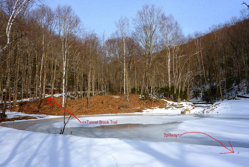
And Andrew, I loved the Blog report that you and Lindsay posted about the falls. That destination has been on my radar for awhile!!:)
===========================

FOLLOW-UP INFO SINCE ORGINAL POSTING OF MY QUESTION:

Subsequent to posting my question, I ran across an article in a 2003 edition of Dartmouth Medicine (click 
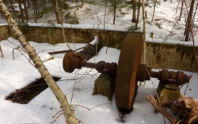
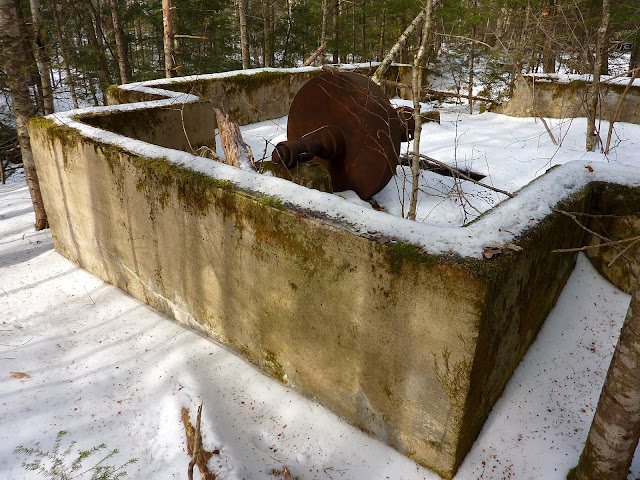
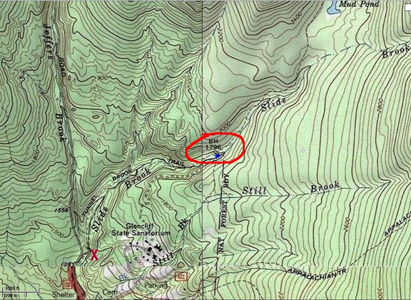
HERE). As might be expected, a lot of this article pertains to medical issues. However, there are some interesting statements that might pertain to the abandoned structure that I found while hiking in the woods near the Glencliff Home.

Near the middle part of the article there is a statement which reads:

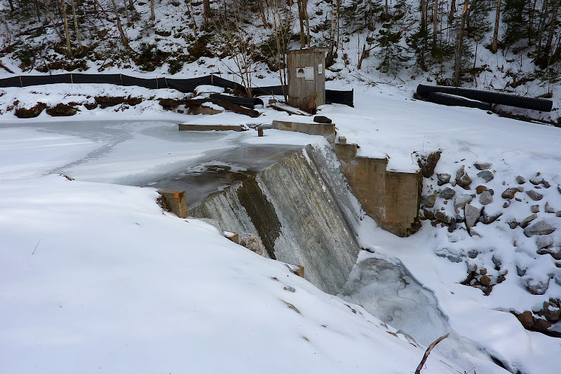
"In the early 1900s, Glencliff was a self-sufficient community . . . Electricity, water, and sewage disposal were all provided by the nearby town of Glencliff."

But then toward the end of the article, there is a statement which reads:

"Glencliff continues to generate its own electricity, using a system of pipes running from a pond on the side of the mountain to a turbine several hundred feet below."

It seems like the two statements above are somewhat at odds with each other. I mean, if the town of Glencliff provided electricity to the old Glencliff Sanatorium in the early 1900s, then why would it be stated that "Glencliff continues to generate its own electricity . . ."?? Maybe I'm just misinterpreting something??:confused:

Regardless, if nothing else, I thought some readers might find the Dartmouth article to be mildly interesting.
 
Peakbagger

The first time I went there I did not even connect that the brook drained carberry, but was struck with a garbage odor. Then I looked at maps and spoke with some woodsmen locals and they confirmed that it did. When I brought Lindsay there I didn't mention the landfill, and after a while she asked "what's that smell?"

It can just be the airflow down the brook valley carrying odor. But you know the best intentions don't always last forever. I personally don't have much faith in lined landfills that they can truly be perforation free forever, or contain water overflow or seepage entirely. Nonetheless it's not a big deal as long as you don't drink or swim if you suspect something, and the place is intensely dramatic and beautiful as well as full of invertabrates in the brook as Lindsay points out.

I meant to mention that if you try to stay close to the brook on the ledges above, which are surprisingly steep and random in arrangement. You can make your way down on the side with the trail and below where it comes to the brook. If you keep your eyes peeled you spot some steel wire (~1") running along the brookbed. I suspected this was part of a plank walkway or handrails for same. When I researched early history and found mention of a trail running right up alongside the falls, it confirmed my assumption. What a day in early hiking when man entered the industrial age and used these new steel tools to 'conquer' nature. Actually to get surprisingly close to natural attractions, think early Flume Trail in Franconia Notch that would turn the stomach of most tourists of today. Very much like the wire ladder up Half Dome in Yosemite (is that the place?) that the CCC built. Too many lawyers today for anyone to want to build stuff like that!
 
Top