How To Hike Katahdin

vftt.org

Help Support vftt.org:

This site may earn a commission from merchant affiliate links, including eBay, Amazon, and others.
So I should expect long sections of trail like The Fan in Huntington Ravine? And why does one not go up this nasty chimney and go down some other route?? Is there a reason people would prefer to descend here?? As much as I want to do this it sounds like you are probably right not to try first time until I've traveled some of the trails and have an idea of overall layout, terrain, vertical, etc.
Ascending the Chimney is a technical route.

Doug
 
IMG_2115.JPG

Descending from Pamola into The Chimney

IMG_2127.JPG

Short better-not-fall zone

It's much less scary than it's billed, as noted above, to ward off the uber casual hiker.

Tim
 
Wow that chimney is quite a scramble! I would not want to go down that. I assume it has no bypass - you must go up or down it? Nice pics Tim. Thanks.
 
Awesome pics! IIRC, I actually thought the scramble down into the col from the Knife Edge was more challenging than the one on the Pamola side. The Pamola one was fun, easy climbing. Might be more challenging for a shorter person though.
 
If you are an avid hiker I suspect this won't be your last trip to Baxter. Since I was peakbagging 20 years ago, we've gone back every two years. There is more to the park than Baxter ... though that alone earned three trips for me ... and it is worth getting to know the ropes.

If you can add one more day to your trip, it could give you a bad weather backup plan and afford you the opportunity to become more familiar with the Park. Look over the trail guides and pick out a plan B.

I like earlier in the summer as much as late summer, mainly because of more daylight. Then again, I'm not as inconvenienced by biting insects as some others ... due mostly to a series of measures to minimize the aggravation.

BTW, I think Woodstock is a beautiful town ... took my family there for Easter dinner.
 
Awesome pics! IIRC, I actually thought the scramble down into the col from the Knife Edge was more challenging than the one on the Pamola side.
It is.

DT: you must pass through Chimney Notch.

The picture is foreshortened and looks steeper than it really is. After you do it, you will probably wonder what you were worried about...

Doug
 
Might be more challenging for a shorter person though.

I had no difficulty at 6'3". Shorter people have fewer options. At no point did I feel I was in trouble, nor did any of the people I was with nor the others that were there with us that day. I don't recall reading or hearing about any serious injuries or fatalities here either.

If you've done Durand Ridge, Six Husbands, Caps Ridge, Huntington's, etc., you will be fine.

Tim
 
I actually thought the scramble down into the col from the Knife Edge was more challenging than the one on the Pamola side I agree, no comparison

My reference to the "controlled slide" is not in the photo. It would be about 180 degrees in the opposite direction. Rarely do a I see a line form to ascend or descend the area in the photo as there are several options and plenty of features to grab onto. There almost always a line on the other side of the Chimney as there is only one way to go with no other reasonable options. The line is mixed blessing, it means that there are usually helpful folks to assist people through the tight section, unfortunately there are also morons who try to push there way through. As there is only room for one person, the morons can inadvertently push a nervous hiker into getting even more stressed and they can freeze up. I have had to assist a couple of times getting someone who is darn close to frozen down over this section. In one particular case I and a couple of companions had to inform a group that was trying to push their way through they had three options, back off and give people space, turn around and find another route or jump. They were pissed but they did finally shut up and back off and then it took about 15 minutes to work a frozen hiker down through. Another great reason for leaving as early in the morning as possible as the moron factor seems to increase as the day goes on.
 
Another perspective. When I hiked Katahdin, I went up Cathedral, across the Knife Edge, and down Helon Taylor. For pretty much the entire hike I played leap-frog with a group of 20'ish year old girls, one of whom had a prosthetic arm. So she did Cathedral, Knife Edge, and the Chimney notch with one arm. She was about 5'3''. She didn't need to do anything magical. She just took her time and used the available hand holds. Just another data point for those who are concerned about the difficulty level.
 
You should be fine. I need to get back there, only been back once since the late 1990's.

There was a Best Western in town & another motel with a pool and hot tub which was nice after hiking. As others said, mid-week is best. Give yourself a few days. Since you've done the NH48, after Katahdin, you may be back for Hamlin & North Brother, the other 4K peaks. (Coe, Fort & South Brother are on the NE 100 highest.)

Ponds along the way to the Brothers are great moose spots and Sandy Stream Pond, near Roaring Brook and on the way to South Turner, is almost a guarantee moose sighting. (South Turner's summit view of the Katahdin Basins made the photo credits in Forest & Crag)

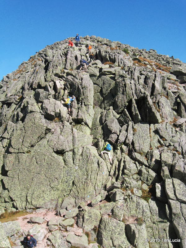
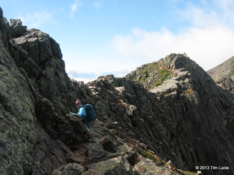
My two trips up Katahdin was an up and back from Roaring Brook using the Saddle Trail the day before the 7/4 holiday years ago & I was able to show up at 7:30 and get in. (Those days are likely gone) The other was a trip up Helon Taylor, across the KE and then over to Hamlin & down Hamlin Ridge. If you can pick a perfect day, I'd reverse that second trip. Only issue I have with BSP (it's a tin issue) is that all day hikers start about the same time as they enter the pack about the same time. Trails to the top are about the same distance so it can get crowded on the top. (Not Washington crowded) Doing Hamlin first would get you to Baxter Peak after many have left, it may put you in the PM Thunderstorm part of the day though.

Besides the Brother's Loop, OJI. The Owl, South Turner and Double Top are worthwhile too. IMO, in the East, there is BSP and then everything else.
 
It's much less scary than it's billed, as noted above, to ward off the uber casual hiker.

It is worth noting that if you have a fear of heights, there are a few sections that might give you the willies. This is now something I ask people before hiking with them. One of the friends we brought across turns out wasn't too keen about heights, but even he made it!
 
It is worth noting that if you have a fear of heights, there are a few sections that might give you the willies.

Probably not any more so than some of the harder WMNF trails mentioned throughout this thread. It is probably the most-challenging, commonly-used route to a NE67 4K. But, it gets done 1000s of times per year.

Tim
 
The ranger station at the park entrance does not have electricity, so entrance fees must be paid in cash. They do not accept credit cards.
 
I'm not afraid of heights but I wouldn't categorize myself as an accomplished rock climber or scrambler. I've done the hardest trails in the Whites but I don't exactly go flying up them without a moments hesitation. I'm more deliberate because of my lack of agility. Sheer vertical is my biggest problem because my upper body and hand strength is poor. On Huntington Ravine I personally find the smaller chimneys and scrambles well up the head wall to be far worse than the huge flat ledge after the brook crossing at the beginning. If the terrain is jagged enough to get a good grip I'm generally fine.

Printed a bunch of stuff off Baxter website yesterday and stopped at EMS for a few maps and the AMC Guide for Maine. The more I read about this the more I think I'm going to make this happen this summer.
 
Probably not any more so than some of the harder WMNF trails mentioned throughout this thread. It is probably the most-challenging, commonly-used route to a NE67 4K. But, it gets done 1000s of times per year.

Tim

I think it was the precipitous drop off to the sides that was getting to him. It's different thank going up something that really steep like 6 husbands, because you're not really going up or down a lot - just across the very narrow ridge. I haven't done the Airline trail yet, but I'm excited to know that it warrants a comparison!
 
The Airline Trail (on Mt Adams I assume we're talking) is very scenic but is quite tame. Would be nowhere near by 10 toughest for the Whites. I was pretty disappointed with it as a comparison to Katahdin. Nice trail though.
 
You can check my trip reports at http://1slowhiker.blogspot.com/2013_09_04_archive.html and http://1slowhiker.blogspot.com/2013_09_05_archive.html for other options using the bunkhouses. Like you, I hike solo and have an 8 hour drive up (RI) . I drove up and hiked to Chimney Pond bunkhouse my first day then did Baxter & Hamlin via Dudley and the KE on day 2 then stayed at a bunkhouse at Nesowanehunk the 2d and third nights doing the Coe, Brothers, and Fort loop on the 3rd day. (I’m the red dot in one of Tim’s pictures in the last link he posted above. It was my most favorite hike ever. I just went back and checked my trip report and think I may repeat it again in Sept. Also if you stay in the park they will tell you if you go out you have to be back by 8 or 10 but you don't really. The ranger at the gate told me that if i was late getting back to the gate that i could improvise (drive around the gate) wink - wink. Also if you look at the roads in BSP maps keep in mind that they are narrow dirt roads and also used by moose so keep it slow and expect long drives from the gate to the THs.

Finally got a chance to review your links. Thanks! These were invaluable for seeing what the terrain is like and will be great planning resource. What a mountain!
 
Note that the water in the park is untreated, so you may want to bring as much as you can from home.

The roads are rough, so you can’t make good time. Twenty or thirty minutes to get to Roaring Brook, I think, and it’s only about eight miles from the Togue Pond gate. Probably at least that long to drive to Abol or Katahdin Stream campgrounds.

There’s a gate up north, too, but it’s that much farther away, of course, and I don’t recall any real town at that end. Not very close, anyway.

I haven’t been there since 2006, but I think that if you camp in the park, you pay the entrance fee once, and it’s good for the length of your stay, whether you actually camp there each night or not (but you’d have to have paid for each night as though you were camping). If you stay outside the park, you pay each day when you enter.

I don’t think you’re supposed to use any electronics at all, although I saw a ranger wearing earphones once. They must have been plugged into something.

I wonder if the Google Street View car has been up that way.
 
Last edited:
I canoed the Allagash years ago. We left form Baxter and were on the river for a week. What I can tell you is, be prepared for rain and thunder at any time. It down poured every night with thunder and lightning. I think we went 4th of July week.
Mike Z
 
Just a side note, the Rangers can and do "close the mountain" if there is poor weather. We were there on Columbus Day weekend a few years back, and with rain forecasted they closed all trails on the mountain.

We went up anyway mid-morning, and as we reached the Tablelands it was socked in. On the way down, still on the Tablelands, the wall of clouds blew away and we saw the most amazing views we've ever seen. Sadly, we never got to see the Eastern side (and Knife Edge) up close.
 
Top