Bridge Status In Pemi Wilderness

vftt.org

Help Support vftt.org:

This site may earn a commission from merchant affiliate links, including eBay, Amazon, and others.
There is no longer a trail from the Bondcliff Trail connecting to the Thoreau Falls trail (in the valley). The East Side Tr. is not bad. I would recommend hiking up the East Side, and cross the Pemi on the Thoreau Falls Tr. bridge. Keep in mind the 200' restriction on camping near trails.
 
There are a couple washouts after the tent-sites. Both are easy to get past/around. This is the worst of the 2.

P8250022.JPG
 
Whatever washout there are will still be easier than that bushwhack. I skied up to the Cedar Brook trail 2 winters ago and it wasn't too bad. There is one big section of washout that is avoidable as I recall. I didn't go from Cedar Brook to the Thoreau Falls trail, so I don't know what shape that is in, but at the point it's the Wilderness trail. The Thoreau Falls trail has one big washout on the trail that has a re-route (or a pretty office herd path) around it. It was pretty obvious when we did it last November.
 
Thank you all for your input. It looks a lot better than I had imagined! Have a great day and happy trails to all.
Gordon
 
Sorry to still be confused but is there a bridge across the pemi at the south end of the Thoreau Falls trail? I see that there is a bridge there somewhere but not knowing the trail am not sure where that bridge is.
Thanks for the help.
Gordon
 
Sorry to still be confused but is there a bridge across the pemi at the south end of the Thoreau Falls trail? I see that there is a bridge there somewhere but not knowing the trail am not sure where that bridge is.
There is a bridge (over the East Branch of the Pemi) on the Thoreau Falls Trail just N of the junction with the Wilderness trail, just N of the junction between the N Branch and the E Branch. Marker D on the map.

There is also a bridge (over the Franconia Branch) on the Lincoln Woods Tr. At marker F.

There used to be a bridge (over the East Branch of the Pemi) at Marker E, but it and the trail leading up to it were removed several years ago.

Map: http://mapper.acme.com/?ll=44.10633...10116,-71.57277,7.8 km SE of Mount Lincoln NH
BTW, this map is the USGS topo and there have been some changes in the trails since it was made. Check the latest AMC map for the most up-to-date trails.

FWIW, I skied this winter from Zealand to Lincoln Woods via Shoal Pond Trail and the Pemi East Side Trail. I can't tell you what was under the snow, but there were no inordinate difficulties with the trail. Others skied a similar route except they used the Thoreau Falls Trail instead of the Shoal Pond Trail. Perhaps one of them will speak up, but I don't recall any reports of inordinate difficulties.

Doug
 
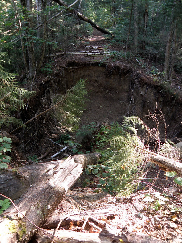
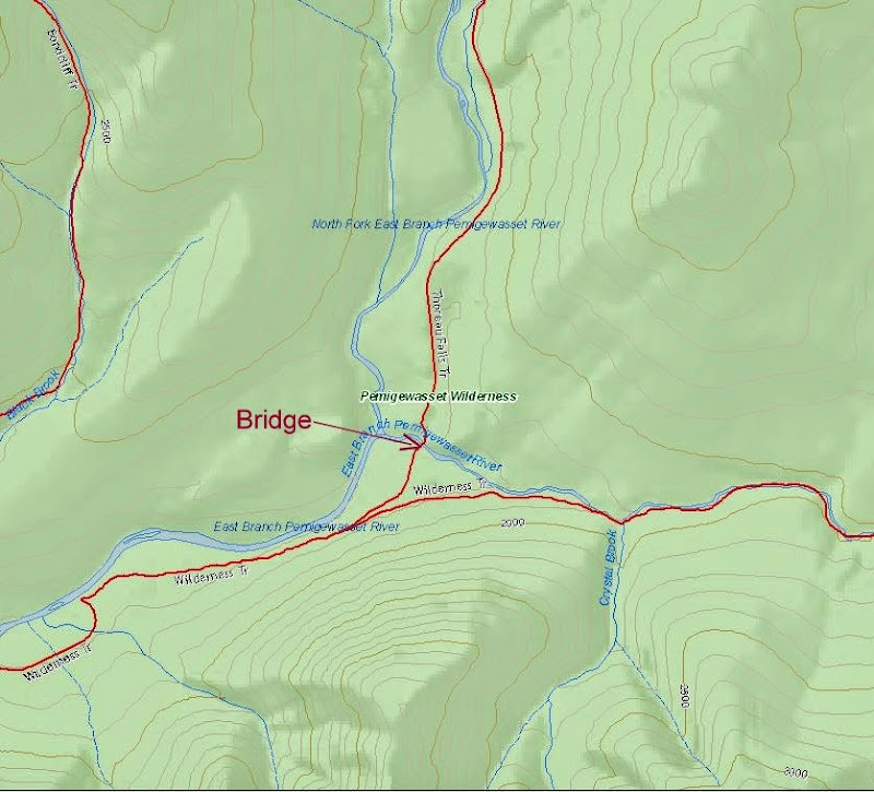
Note, that for added confusion, when the bridge over the East Branch was removed, portions of certain trails were renamed. The "Wilderness Trail" is now completely on the east side of the East Branch, and the "Bondcliff Trail" now starts at the Wilderness boundary on the west side of the East Branch/north side of Franconia Brook. So when looking at any pre-2008 description of this area, the "Wilderness Trail" isn't what is on the current maps.

In current parlance, the trail on the east side of the East Branch is the "East Side Trail" up to the Wilderness boundary, and the "Wilderness Trail" beyond. The trail on the west side of the East Branch is the "Lincoln Woods Trail" up to the Wilderness boundary, and the "Bondcliff Trail" beyond. You will note that these aren't the names that appear on DougPaul's map link (in fact, his is the even older version, that shows the "Wilderness Trail" going all the way to the Kanc, and the current "East Side Trail" is shown as an unnamed road).

Note that many maps (including the AMC maps, and the map on the trailhead kiosk at the Lincoln Woods trailhead), show an unnamed trail that crosses the East Branch just above Franconia Brook, connecting the (now) Bondcliff Trail to the East Side Trail in the area of the Franconia Brook East Tensite. You should consider this trail to be a work of fiction. It is sometimes passable at low water, and in the "olden days" you would just continue upstream to the suspension bridge if it was an issue. Now, if you can't cross, you have to backtrack to the trailhead (5+ miles round-trip). I have no idea why the FS still considers this to be a trail, since I was told in 2009 that the FS intentionally removed/disturbed the rocks that served as stepping stones at that location to discourage its use (of course, it's possible I was lied to). And that was before Irene & Sandy reworked the river bed in that area in a big way.
 
That clears it up for me!

TFTB.JPG


Said bridge.
P8250033.JPG

Thanks folks. Now it is crystal clear and I am all ok with what I can expect on a hike up the est side and then on the Thoreau trail to
Zealand. My next hike (on 8/24 - 8/26) will be from the Zealand trailhead to Zealand Falls hut day 1 then over to Garfield hut on day 2
then down to my car left at the trailhead for Garfield hut. I have been doing a lot of steep (for me anyway) climbing the past few weeks
to insure that I will be ok on the section from Zealand hut up to Zeacliff where it rises about 1100' in 1.3 miles. Looks like I can do it ok.
Now for good weather!
Thanks again all.
Gordon
 
Top