
You are using an out of date browser. It may not display this or other websites correctly.
You should upgrade or use an alternative browser.
You should upgrade or use an alternative browser.
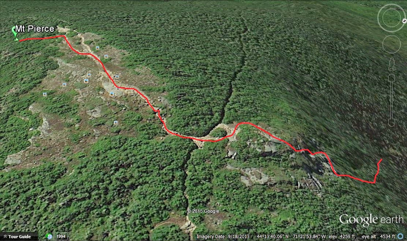
Hikers rescued from Mt Pierce
- Thread starter Mike
- Start date
Help Support vftt.org:
This site may earn a commission from merchant affiliate
links, including eBay, Amazon, and others.
Tom Rankin
Well-known member
"The hikers were finally located unharmed about 11 p.m. near the summit in Bean's Grant and walked out with officers."
Bean's Grant? I looked it up:
http://en.wikipedia.org/wiki/Bean's_Grant,_New_Hampshire
Bean's Grant? I looked it up:
http://en.wikipedia.org/wiki/Bean's_Grant,_New_Hampshire
NH has several small and large unorganized townships in Northern NH, the majority never have had enough population to create an official town. Their jurisdiction falls under county government. For those who do live in those towns, the property taxes are frequently offset by timber tax revenue leading to the property owner paying no sales, state income tax or property tax. The trade off is darn close to zero services and good luck if one ever needs ambulance, police or fire service.
Tom Rankin
Well-known member
Sounds like live free or die (or maybe live free AND die!NH has several small and large unorganized townships in Northern NH, the majority never have had enough population to create an official town. Their jurisdiction falls under county government. For those who do live in those towns, the property taxes are frequently offset by timber tax revenue leading to the property owner paying no sales, state income tax or property tax. The trade off is darn close to zero services and good luck if one ever needs ambulance, police or fire service.
") ) to me!
) to me! Chip
Well-known member
Wind and snow were ROARING through Crawford Notch yesterday afternoon and there weren't many hikers out that might have helped.
sierra
Well-known member
Pierce being my favorite peak and all, I thought I'd chime in. The section from the Webster Cliff trail junction with the Crawford path to the summit is short ( about 500 yrds.) BUT, it can be an epic to navigate in rough conditions. One day in near whiteout conditions, I actually wanded the entrance to the woods to halfway up to the summit, to ensure a safe retreat. It drifts over and if your not great in those conditions, it can be very hard to find your way back into the safety of the woods and the Crawford path.
sardog1
New member
- Joined
- Nov 8, 2003
- Messages
- 2,579
- Reaction score
- 231
I have for years advocated Pierce as a good destination for newbies wanting a small, relatively safe taste of winter hiking. After this event, it looks like I'd better add a cautionary note to that suggestion.
Mike P.
Well-known member
I have for years advocated Pierce as a good destination for newbies wanting a small, relatively safe taste of winter hiking. After this event, it looks like I'd better add a cautionary note to that suggestion.
Me too. I've lost the trail before up high on the C-path having wandered to the right just before treeline. Knowing the map and area though, I knew I'd come out on the Webster Cliff trail as long as I kept going up. On my day, wind was not an issue but visibility was under 100 feet. Four hours of Daylight in that area I'd think would have allowed some map and compass work to find a way down.
Will wait and see if we learn any more details on what they had with them. Apparently they had warm gear to be fine eight hours after calling for assistance.
sierra
Well-known member
I have for years advocated Pierce as a good destination for newbies wanting a small, relatively safe taste of winter hiking. After this event, it looks like I'd better add a cautionary note to that suggestion.
I think your suggestion of Pierce for aspirering winter hikers is a very valid one and also a mountain I steer people towards. The only thing I would and do add to any winter trip suggestion, is this. If conditions are not favorable, ie. visibilty, wind chill factor, or route finding of the trail, do not proceed above treeline period. There are plenty of sheltered and wooded peaks to practice on. Above treeline hiking in the Whites takes experience, the learning curve is thin in bad conditions. Most of us, lost up there could figure out a way out pretty fast, even if not right on the trail. But beginners lack the combination of many factors in getting out of dicey condtions, we may take for granted.
SherpaWill
Member
Years ago me and a friend camped in this area in February. We woke up to white out conditions and the trail was completley covered from the snow we got overnight. We could not find the trail connecting back to Crawford's heading below tree line. We ended up going up to the Summit and taking Webster Cliff trail down to the hut and Mizpah Cut Off back to Crawford's. To this day I still can't figure out why it was so difficult to find that trail.
JustJoe
Active member
I have for years advocated Pierce as a good destination for newbies wanting a small, relatively safe taste of winter hiking. After this event, it looks like I'd better add a cautionary note to that suggestion.
When I decided to give winter hiking a shot I started with Pierce. An overcast by fairly uneventful winters day, until I reached the summit. In the clouds and and blowing snow. My first descent off the summit went roughly like this like this.
I will admit for about 30 seconds I panicked. Then calmed down and realized I couldn't be more than 25 yards from the cairn I just passed. Needless to say it was a humbling experience. But looking at the topography, it was easy to do.
Hikers have also gotten lost heading south on Webster Cliff trail from the Pierce Summit to Mitzpah hut. There are a couple of spots in winter where the trail is less obvious than some open snow covered areas in the woods. If there is not a crust, its pretty obvious once a hiker steps off a packed trail but on year with crust its easy to get turned around.
Creag Nan Drochaid
New member
- Joined
- Nov 5, 2009
- Messages
- 331
- Reaction score
- 33
Good summaries in posts #8 and #9.
There is a reason we call the alpine zone the death zone. IMHO we in eastern USA are so accustomed to following trails that many of us neglect to learn the habits of map study, writing or memorizing magnetic compass bearings, and open land off-trail navigation. Those of us who go to the alpine zone or other tree-less places find we must learn and practice those skills till they are habits if we want to reach safety. We can only offer more trainings and warnings, but that is about all we can do before we cross the line of requiring hikers to pass safety courses to hike. None of us wants to go there, and we accept these as facts and we assume these risks as part of the challenge of going to wild places. To quote the AMC guidebooks, "Hiking is a sport of self-reliance."
There is a reason we call the alpine zone the death zone. IMHO we in eastern USA are so accustomed to following trails that many of us neglect to learn the habits of map study, writing or memorizing magnetic compass bearings, and open land off-trail navigation. Those of us who go to the alpine zone or other tree-less places find we must learn and practice those skills till they are habits if we want to reach safety. We can only offer more trainings and warnings, but that is about all we can do before we cross the line of requiring hikers to pass safety courses to hike. None of us wants to go there, and we accept these as facts and we assume these risks as part of the challenge of going to wild places. To quote the AMC guidebooks, "Hiking is a sport of self-reliance."
My husband and I volunteered this weekend at PNVC - me as a trail information person (he hiked to Hermit Lake Shelter both days to help the caretakers). On Friday at 6:30 there were two groups in trouble: one called 911 and one had friends that called in because they hadn't yet arrived from their day on the mountain. 911 group wound up making their way down and having dinner (unbeknownst to the 911 folks involved). The ones whose friends had called found their friends eventually and the group was having dinner nearby. All was okay until around 8:30ish a call came in from a cell phone indicating that someone was yelling for help by the steeps on Lion Head Winter trail. He apparently had fallen twice . They got him down by about 2am Saturday via litter - with injured ribs and leg. He came in to the visitor center on Sunday hoping staff at Harvard or Hermit Lake would look for his backpack which he had unhooked to right himself the first time he fell (and of course the second fall separated him from his pack). He had a lot of equipment and was hoping to retrieve some of it but re emphasized how grateful he was to have been brought safely down. The weekend staff, exhausted, was not inclined to go looking for the pack. Especially since the guy stated that the second time he fell he heard it shushing down slope - a loooong shush.
Last edited:
Stan
Well-known member
Any winter hike can become a navugational challenge if the trail is unbroken and the blazes are obscured by snow or ice. I think of it much like any bushwhack and think about escape routes before the hike, noting geographic features and compass directions. All the detailed advice in the world might be useless if you do not have basic map and compass skills ... even if your primary navigational tool is the GPS.
Brambor
Well-known member
yep. Me too. Pierce is the first 4K I recommend to newbies. I probably still will but the report yesterday surprised me.
Pierce is the first 4K I recommend to newbies. I probably still will but the report yesterday surprised me. I have for years advocated Pierce as a good destination for newbies wanting a small, relatively safe taste of winter hiking. After this event, it looks like I'd better add a cautionary note to that suggestion.
Brambor
Well-known member
We were on top of Saddleback Saturday in what was probably 40mph winds. With low visibility and wind pushing us around my friend was leading the descent and pretty much wandered past the last trench from which we ascended. Our tracks disappeared in 5 minutes due to the blowing snow.
Years ago me and a friend camped in this area in February. We woke up to white out conditions and the trail was completley covered from the snow we got overnight. We could not find the trail connecting back to Crawford's heading below tree line. We ended up going up to the Summit and taking Webster Cliff trail down to the hut and Mizpah Cut Off back to Crawford's. To this day I still can't figure out why it was so difficult to find that trail.
Driver8
New member
- Joined
- Aug 13, 2012
- Messages
- 779
- Reaction score
- 0
Thinking about this, as I sometimes think about the winter storm above tree-line scenario, I think of all the tools and resources one can call on during the situation. Which leads to a question:
if the wind whipping up the snow and causing white-out is from a consistent direction, does anyone ever use it as a navigational aid in itself? If it's a steady 315'er, for instance, it could be handy to maintain a certain bearing against it. No good if it's swirling, but might work sometimes, the thought goes.
The thing it's hard to keep in mind is that when it's white-out, you've got few to no visual cues. Better hope your compass is working!
I'd be interested, if it's not considered as veering too far off topic, to hear ppl's stories here of how they successfully got out of white-out conditions and safely onto followable trail sheltered by trees or terrain. Maybe it would be better to set that up as a separate thread, so it turns up in searches in the future.
John in NH
Member
I would continue to say that Pierce is a good first time winter 4k target since the trail is usually one of the first packed after a snow and there is usually some kind of traffic on the trail. Very easy overall. BUT it would definitely be appropriate to add the cautionary note for winter that if visibility is bad, be disciplined enough to turn around before proceeding above treeline. The open area has little to offer navigational help if you can't find an existing footbed if blowing snow erases it.
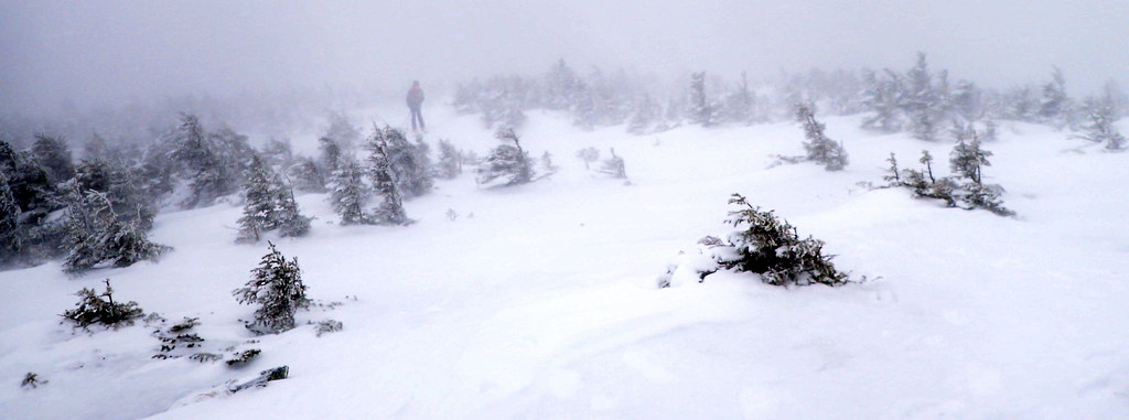
The following photos illustrate this. They were taken from this past December (2014) on a day when the forecast was for mostly sunny in the valley and in and out of the clouds on the summit. Instead it snowed lightly the whole time and there was a white out on the summit.
Here are two hikers approaching the summit area about 50 feet from me. You probably can't see the 2nd hiker.

When I was leaving the summit after a 30 minute stay, things were worse. There is a hiker again less then 50 feet away dead center.

Can you see the cairn in the upper center, can you find it? Not much in the way of rocks or vegetation.

These photos are exposed properly as I saw it.
The following photos illustrate this. They were taken from this past December (2014) on a day when the forecast was for mostly sunny in the valley and in and out of the clouds on the summit. Instead it snowed lightly the whole time and there was a white out on the summit.
Here are two hikers approaching the summit area about 50 feet from me. You probably can't see the 2nd hiker.
When I was leaving the summit after a 30 minute stay, things were worse. There is a hiker again less then 50 feet away dead center.
Can you see the cairn in the upper center, can you find it? Not much in the way of rocks or vegetation.
These photos are exposed properly as I saw it.
Last edited:
Similar threads
- Replies
- 1
- Views
- 738
- Replies
- 69
- Views
- 4K
- Replies
- 18
- Views
- 1K
- Replies
- 12
- Views
- 1K