http://www.pressherald.com/2016/02/02/wind-power-critics-dismayed-by-scale-of-proposed-project/
If you look at the inset map, the proposed farm west of Eustis lines up with the "six pack" peaks. The applications for the power supply contracts do not contain any specific siting info that I could locate so exactly where the farm or farms are built are speculation on my part. Years ago during the first wind rush, a developer tied in with Zond Wind had installed wind monitoring equipment on the West Kennebago tower for a proposed wind farm. It was within sight of the enclave of private camps and the private sporting camp on Kennebago lake. The owners of these camps tend to be well heeled individuals who like their privacy and reportedly anyone attempting to drive down the road would be met by a caretaker and turned around. They had political clout and behind the scenes they "encouraged" the developer to go elsewhere allegedly by threatening to keep the project in court for years. One high profile frequent visitor was Barbara Walters. The developer eventually moved the project to the Kibby Range and about 25 years later a wind farm was built and a second one followed.
One of the Maine native tribes owns Snow Mtn (east of Big Island Pond) and has been actively monitoring wind but has not yet developed the site. Access to Boundary Peak would be difficult as the topo to the east is steep so any access would need to parallel the US boundary swath. This leaves the Whitecap Kennebago divide range with possibly Cupsuptic Snow as ideal wind sites as they have reasonable wind exposure and the ridge line is potentially suitable for an access road. East Kennebago is also a prime location but given its location relative to Kennebago lake it may also suffer the wrath of camp owners
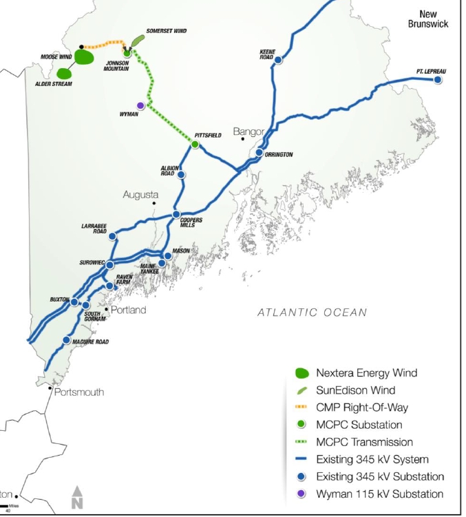
The main reason this area of Maine lacks wind development currently is lack of transmission line capacity locally and downstream. Central Maine Power completed a major transmission line upgrade a few years ago partially funded by all New England ratepayers. Prior to that project, the grid in Maine was constrained so that when southern New England wanted power Maine had limited capacity to supply it. Now that the big money was spent, well connected entrepreneurs are rushing in to use of that capacity preferably using southern New England rate payers to pay for it. Unlike Northern Pass in NH , the Maine government is actively supporting transmission projects so eminent domain is available to site the transmission lines with little recourse to the landowners.
Maine used to have fairly extensive protections in place for unorganized territorys which lack local government but coinciding with the change in administrations, the regulations have been watered down making permitting easier. Some wind farms have been blocked generally in areas where there are private inholdings typically along remote lakes but to date wind farms in traditional commercial timberland tend to get approved. Maine Audubon, who used to oppose wind turbines was bought off a few years ago so there isn't a lot of viable opposition with the exception of one or two entities that earn a living off of opposing wind projects http://news.mpbn.net/post/settlement-ag-maine-anti-wind-group-must-reform#stream/0.
The reality is if incentives keep getting thrown at intermittent wind projects, its likely the Six Pack area if not the Six Pack itself is in for changes. To someone just out to click summits off a list it may be plus as I expect the roads and bridges will be upgraded and maintained to a higher standard. Of course, the owners could also elect to block access to the roads so the hike in could be a lot longer. I personally will miss the adventure of heading up there, it required planning and was always a risk that the road or bridge that was open last year would be closed this year. It also gave a lot of folks their first real up close exposure to the vast commercial timberlands that cover much of Maine.
If you look at the inset map, the proposed farm west of Eustis lines up with the "six pack" peaks. The applications for the power supply contracts do not contain any specific siting info that I could locate so exactly where the farm or farms are built are speculation on my part. Years ago during the first wind rush, a developer tied in with Zond Wind had installed wind monitoring equipment on the West Kennebago tower for a proposed wind farm. It was within sight of the enclave of private camps and the private sporting camp on Kennebago lake. The owners of these camps tend to be well heeled individuals who like their privacy and reportedly anyone attempting to drive down the road would be met by a caretaker and turned around. They had political clout and behind the scenes they "encouraged" the developer to go elsewhere allegedly by threatening to keep the project in court for years. One high profile frequent visitor was Barbara Walters. The developer eventually moved the project to the Kibby Range and about 25 years later a wind farm was built and a second one followed.
One of the Maine native tribes owns Snow Mtn (east of Big Island Pond) and has been actively monitoring wind but has not yet developed the site. Access to Boundary Peak would be difficult as the topo to the east is steep so any access would need to parallel the US boundary swath. This leaves the Whitecap Kennebago divide range with possibly Cupsuptic Snow as ideal wind sites as they have reasonable wind exposure and the ridge line is potentially suitable for an access road. East Kennebago is also a prime location but given its location relative to Kennebago lake it may also suffer the wrath of camp owners
The main reason this area of Maine lacks wind development currently is lack of transmission line capacity locally and downstream. Central Maine Power completed a major transmission line upgrade a few years ago partially funded by all New England ratepayers. Prior to that project, the grid in Maine was constrained so that when southern New England wanted power Maine had limited capacity to supply it. Now that the big money was spent, well connected entrepreneurs are rushing in to use of that capacity preferably using southern New England rate payers to pay for it. Unlike Northern Pass in NH , the Maine government is actively supporting transmission projects so eminent domain is available to site the transmission lines with little recourse to the landowners.
Maine used to have fairly extensive protections in place for unorganized territorys which lack local government but coinciding with the change in administrations, the regulations have been watered down making permitting easier. Some wind farms have been blocked generally in areas where there are private inholdings typically along remote lakes but to date wind farms in traditional commercial timberland tend to get approved. Maine Audubon, who used to oppose wind turbines was bought off a few years ago so there isn't a lot of viable opposition with the exception of one or two entities that earn a living off of opposing wind projects http://news.mpbn.net/post/settlement-ag-maine-anti-wind-group-must-reform#stream/0.
The reality is if incentives keep getting thrown at intermittent wind projects, its likely the Six Pack area if not the Six Pack itself is in for changes. To someone just out to click summits off a list it may be plus as I expect the roads and bridges will be upgraded and maintained to a higher standard. Of course, the owners could also elect to block access to the roads so the hike in could be a lot longer. I personally will miss the adventure of heading up there, it required planning and was always a risk that the road or bridge that was open last year would be closed this year. It also gave a lot of folks their first real up close exposure to the vast commercial timberlands that cover much of Maine.