North, Middle, South Carter - NH

vftt.org

Help Support vftt.org:

This site may earn a commission from merchant affiliate links, including eBay, Amazon, and others.

Darkmatter

New member
Joined
Oct 13, 2015
Messages
59
Reaction score
0
Location
New Jersey
Finally made it back to the Whites to bag a few more peaks I haven't done before and it was a great little trip despite getting rained on for a short time. Luckily there were no thunderstorms at least. Although I will say it was a bit of a challenge figuring out exactly where the summits were for these three!

Pictures and Full Report at the link....

https://operationalaska30.com/2016/...e-and-south-carter-white-mountains-nh-8-6-16/
 
Too bad about the road walk, the Dodge Cutoff through Cap Dodge cuts it down to a much shorter walk.

I guess you didn't get attacked by the resident Spruce Grouse near middle carter?
 
There used to be small signs on those summits but I think they were removed. My 2002 photos are not digital.

Those would of been pretty helpful. I cant even find any photos of them online. I assume they have been gone a while at this point.

Too bad about the road walk, the Dodge Cutoff through Cap Dodge cuts it down to a much shorter walk.


I guess you didn't get attacked by the resident Spruce Grouse near middle carter?

Hmm I didnt see that trail on my map. That would of been a much better option. Also I didnt get attacked by the Spruce GrOuse but now Im wishkng I had! Guess the rain kept him aeay.
 
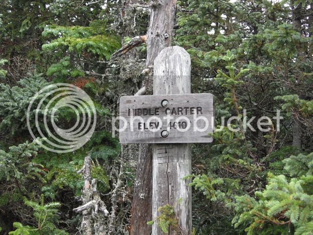
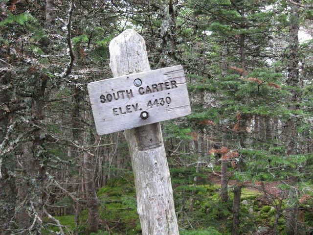
I found these on an old Dave Metsky TR coincidentally also from 2002. Dave, I assume its ok to copy these. Anyone know when the signs disappeared?

top2[1].jpg

middle03[1].jpg
 
Thanks for the pictures. I wish the signs were still there it would of been helpful. In the thread you linked they said they were removed due to not being relevant for navigation but I would argue knowing how far down the ridge you are at different points is very relevant for navigation. It could be useful information if you are on the fence about turning around etc.
 
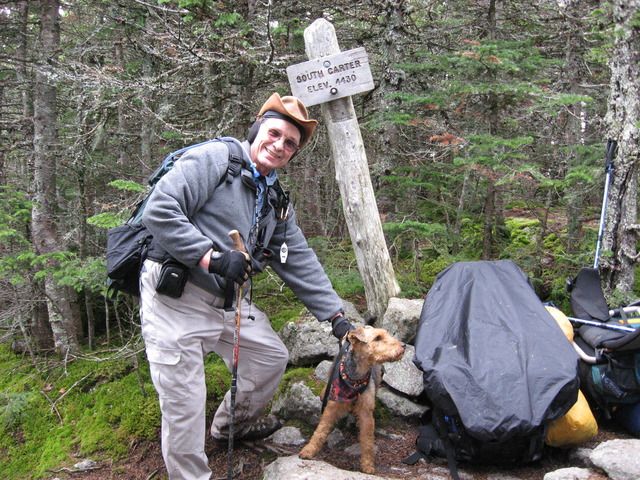
It's interesting that you ask about the pictures. I took these pictures on 10/04/08. I was doing the Carter loop with Lauky. We were on our way down from South Carter towards Zeta Pass when we met the young ranger coming up to take down the signs. The pictures I took are probably the last that were ever taken of those signs.


Thanks for the pictures. I wish the signs were still there it would of been helpful. In the thread you linked they said they were removed due to not being relevant for navigation but I would argue knowing how far down the ridge you are at different points is very relevant for navigation. It could be useful information if you are on the fence about turning around etc.

My White Mountain activity ramped up in 2007, and at that point the signs weren't there. However, fear not for navigation -- these signs *were* there. The South Carter sign is still present. I don't specifically remember seeing the Middle Carter sign of late -- the photo is from 2013.

Alex

0_0_df56e16e9d48818afac0a4c529a786ad_1
0_0_043a420db7e8482acf960b9a5ae0ea57_1
 
... I guess you didn't get attacked by the resident Spruce Grouse near middle carter?

Back in late March, he chased me from the South-Middle col almost all the way to the Middle summit cone. However, I saw no trace of him when I was back there in May. Coupled with reports from others who were there from May on, and who didn't report seeing him, I fear that something may have happened to him -- unless there's some sort of seasonal aspect to the aggressive behavior such that he's currently content to live a more discreet existence.

Alex
 
Last edited:
My White Mountain activity ramped up in 2007, and at that point the signs weren't there. However, fear not for navigation -- these signs *were* there. The South Carter sign is still present. I don't specifically remember seeing the Middle Carter sign of late -- the photo is from 2013.

Alex

0_0_df56e16e9d48818afac0a4c529a786ad_1
0_0_043a420db7e8482acf960b9a5ae0ea57_1

Interesting pictures. They're obviously not the ones I photographed. I was told when the signs came down that the Forest Service had decided not to have signs in places where there were no trail junctions. I was last through there, before moving south, in 2012 and I don't remember seeing either of those signs. Are the signs you photographed still there? Where in relation to the trail are they located? The South Carter 'sign' seems to be affixed to a tree, is it next to the trail? Do you think the signs were placed by the Forest Service, they don't look like their typical signs. The lettering, especially on the Middle Carter sign, does not seem up to Forest Service standards. There is no question that having a sign helps to let you know when you have reached the peak. I remember a thread some time back asking what peaks actually had signs. It was interesting how few there actually were. With most of the peaks you know when you are there, but with the Carters and and the bumps along the way it's not as obvious.
 
Back in late March, he chased me from the South-Middle col almost all the way to the Middle summit cone. However, I saw no trace of him when I was back there in May. Coupled with reports from others who were there from May on, and who didn't report seeing him, I fear that something may have happened to him -- unless there's some sort of seasonal aspect to the aggressive behavior such that he's currently content to live a more discreet existence.

Alex

I have now officially seen the infamous spruce grouse, but he was actually over on the ridge near Mt Moriah. Perhaps he has found a new home?
 
Interesting pictures. They're obviously not the ones I photographed. I was told when the signs came down that the Forest Service had decided not to have signs in places where there were no trail junctions. I was last through there, before moving south, in 2012 and I don't remember seeing either of those signs. Are the signs you photographed still there? Where in relation to the trail are they located? The South Carter 'sign' seems to be affixed to a tree, is it next to the trail? Do you think the signs were placed by the Forest Service, they don't look like their typical signs. The lettering, especially on the Middle Carter sign, does not seem up to Forest Service standards. There is no question that having a sign helps to let you know when you have reached the peak. I remember a thread some time back asking what peaks actually had signs. It was interesting how few there actually were. With most of the peaks you know when you are there, but with the Carters and and the bumps along the way it's not as obvious.

As of this past May, the South Carter sign was still there. It's on the backside of a tree at the high point ~15' W of the trail. It's similar to ones on Cabot (no longer there) and Whiteface (still there as of this past October). As I indicated, I don't have a specific memory of the Middle Carter sign after 2013. It was right on the trail, mid summit ridge. I strongly (extremely extremely, in recent parlance) doubt that either work of art came from the FS or AMC.
 
Last edited:
I have now officially seen the infamous spruce grouse, but he was actually over on the ridge near Mt Moriah. Perhaps he has found a new home?

I'm guessing that you've met a different bird. It is a somewhat less traveled stretch, though, if S of the Stonybrook Trail -- so both we and he will meet less often. Good to know about!
 
Last edited:
Top