Mt Lafayette Rescue on Wednesday

vftt.org

Help Support vftt.org:

This site may earn a commission from merchant affiliate links, including eBay, Amazon, and others.
I own multiple GPS devices, I bought one many years ago, it has been collecting dust in one of my closets for many years. I would strongly discourage using GPS as a safety device. It's a toy, nothing more. I have been clocked at 35mph while jogging with my Garmin forerunner, and I lost faith in my trekking GPS when I broke 5500' foot elevation on Camel's Hump in Vt. Relying on GPS alone in an emergency is dangerous. Usually the GPS is accurate to within 1% or 2% in good conditions, but they tend to fall apart in bad weather, like the kind of conditions that were present in the subject of this thread. That said, GPS technology has improved through the years, but I would not trust my safety on it.

Yes, it has improved through the years. Based on the comparison testing I've performed, my phone's GPS hardware performs better than my circa-2007 Garmin Rino 530 HCx (cousin of the revered 60 CSx).

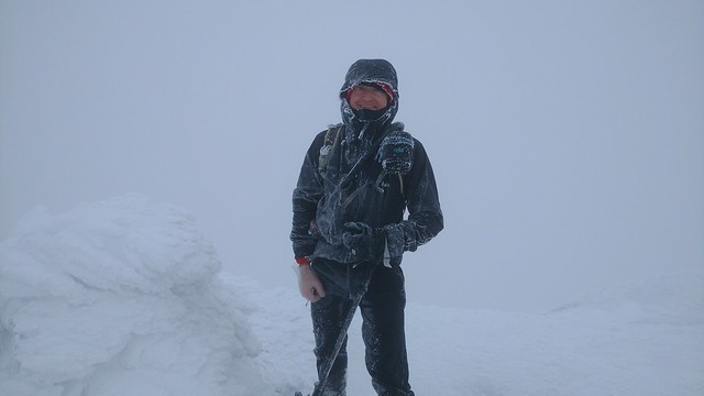
I normally only use it for track-logging but last Saturday (Wright, Algonquin and Iroquois in the Adirondacks) it was handy to navigate in near whiteout conditions (25 feet visibility). I also had a compass and 1:6000 scale map and high familiarity with the route. I decided to see how well my phone would perform and referred to it exclusively; it didn't let me down. Internal battery temperature indicated below freezing ... and it took photos just fine.


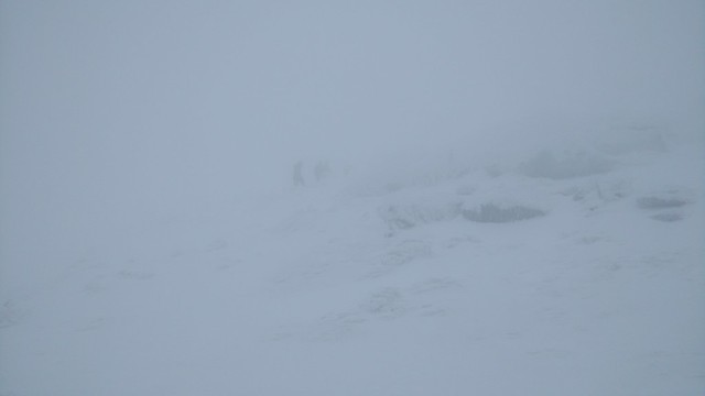
Disappearing into the icy mist.

FWIW, the following day the conditions were no better and the DEC had to assist a group of three hikers who lost their way on Algonquin (they called for help). I agree you need map & compass skills (and an exit plan) when venturing above treeline but, let's face it, many people don't ... but they often have a phone. The phone shouldn't be Plan A ... but if you have one then at least make it useful for self-rescue. My fellow Quebecer, who was rescued on Lafayette, might've walked out under his own power had he parted with a few bucks for a navigation app. Instead, he may be saying goodbye to far more bucks for the rescue. An expensive lesson to be sure.
 
Last edited:
I've carried index cards myself, with various coordinates for different routes to bail on. There are times when pulling out a map is not as easy as it sounds. I'm self taught with a compass, but my sense of direction is second none. Personally, if the conditions are so bad you cant see anything, I'm not up there anyway. As important a skill navigating is, weather prediction may be even more important.

Agreed. The bottom line is that we control the weather on our hikes simply by heeding the forecast and waiting for a good day.
 
I've read the responses to this and honestly, I'm amazed by the unwillingness to use technology. I carry a map, and a compass, but honestly, it's much easier to simply pull out my phone. If I'm not sure of where I'm going (which can happen in unfamiliar territory and not well marked trails), All Trails and Map My Hike have never let me down. I can literally just look at the map on my phone and see where I am at any given time. I can see what trail I'm on and if necessary, follow my own path back down. Of course, I would never head to the mountains and go up them knowing that bad weather could be imminent - that is just something you need to be on top of.
 
Great comments in this thread. Glad the guy and friends are alive and well. As much as we criticize, the reality is this is another success story. Hiker goes out and finds himself lost above treeline in hypothermic, low visibility conditions. USF&G with volunteer S&R personnel go get him and all survive. The plan worked the way it is supposed to. A few comments though, as there are some good points here.

Sad to see just another guy who won't use a gps..
Don't cry for me, Argentina; I'm not using one either. ;) We don't all have the same needs nor desires. Technology exists and helps some people with some tasks. Some choose to use it. Some do not. People succeed and fail in both scenarios. The technology is often not the difference between life and death. There's an elevator at the airport. I use the stairs most of the time. I don't judge those on the elevator. Under different conditions (heavy baggage) or environment (unfamiliar airport), I might take the elevator. Most make it to the gate fine...and we spread out this way.

But, to be fair Capt, if I were on the open water out of sight of land, I'd take the GPS and let the mariners take the lead. Lead the way Captain! Where are we headed? Same person in a different environment, different applicable skills, with different things to consider.

I love how the picture in the Daily Mail shows Franconia Ridge on a clear summer day! Kinda defeats the point of the article....I mean if a point was to make sure that hikers are prepared for bad weather.
I thought the same thing. Wow, doesn't look too rough does it? I am sure a quick post and a hundred people would provide a winter picture from that same location, eager to have a photo in the paper. Probably in a rush to meet the deadline, but a winter picture might make more sense here, no?

I think a lot of people hear 'loop' and think that there is only one trail, not knowing that the ridge has trails the continue in both directions.

I've seen this often as well. I've been asked numerous times, "Is this THE TRAIL to the mountain." It's A trail, yes. To A mountain.

Online sources? Ummm, if you're planning an above-tree line hike, All you do is open up your map, use your compass to protract and record the necessary exit bearings, and if jniehof's post hasn't scared you off, fold up and pack your map. Probably less time than finding and comprehending some web page, with the added bonus that you're not relying on someone else's info.

Alex
This is a guess, but the reference to online sources for the Presi Range may be the list of escape routes by Chauvin Guides that has been available for many years and tossed around campfires. I agree with the general thought that relying on other's info on the web is at best used as a starting point (including mine and yours). If I find the reference, I will edit the post and link it here - I have a paper copy. Not sure if there is one for the Franconia Ridge, but there are far fewer places to get in trouble, not to minimize risk by any means...people get lost there often as you know.

And to agree with Stan, buried in a post back there, extra socks make great backup mittens - save a finger. Good advice.

Out of curiosity did the hiker have to purchase a Hike Safe card to cover the dogs or do dogs get rescued for free? ;)

The new "Bark Safe card" will be deployed in 2018. No kibble, no paw mitts? That dog is negligent.
 
Last edited:
Reading trail reports from yesterday sounds like the majority of those on the loop decided snowshoes were not needed, apparently the trail is quite mess from postholes.

I do like the Bark Safe card concept ;)
 
I've read the responses to this and honestly, I'm amazed by the unwillingness to use technology. I carry a map, and a compass, but honestly, it's much easier to simply pull out my phone. If I'm not sure of where I'm going (which can happen in unfamiliar territory and not well marked trails), All Trails and Map My Hike have never let me down. I can literally just look at the map on my phone and see where I am at any given time. I can see what trail I'm on and if necessary, follow my own path back down. Of course, I would never head to the mountains and go up them knowing that bad weather could be imminent - that is just something you need to be on top of.

Some of us were hiking long before GPS and phone applications were around. Compasses and maps don't freeze or die. If you use technology, that's great if it does what you need, but your phone won't cut it in bad conditions. I never moved onto devices, simply because I don't need them.
 
Some of us were hiking long before GPS and phone applications were around. Compasses and maps don't freeze or die. If you use technology, that's great if it does what you need, but your phone won't cut it in bad conditions. I never moved onto devices, simply because I don't need them.

I've never seen a phone blow away in high winds. The screen is bright enough that I can see it in any conditions without needing to figure out how I'm going to hold a flashlight if it's dark out and I don't have to "find" my way or determine what direction to go in because I can just look and see what direction I need to go in. I think it's easier.
 
I've never seen a phone blow away in high winds. The screen is bright enough that I can see it in any conditions without needing to figure out how I'm going to hold a flashlight if it's dark out and I don't have to "find" my way or determine what direction to go in because I can just look and see what direction I need to go in. I think it's easier.

I was referring to cold conditions killing your phone. I'm not impuning your methods, simply pointing out potential pitfalls. I've had many days up high in temps that would render a phone useless. That was my only point.
 
Yesterday was a good example of a day I needed my compass handy.

Leaving from the base road, conditions were not bad, but you could tell it was going to be pretty windy above treeline.

Nearing LOC Hut, the wind was intense in the last few exposed tenths. From the final safety of the trees, I made sure I knew my bearings to the hut and back and had a compass around my neck to look at quickly as needed. The pellets in the wind felt like sand blasting. A group of three was out of the wind at the hut. I ducked into a corner, dropped my pack, and took a quick video of the wind.

I turned and headed down pretty quickly after getting my fill of playing in it, as it seemed the wind was actually picking up speed. The exposed stretch from the hut down to the safety of the ravine and trees was crazy windy and just enough for me yesterday. Averaging over 70 on Mount Washington all day and up to 100 mph. It felt like it. Ideally I had hoped to get up Monroe. I may not have come back down if I had continued on that final three tenths. The last time I was on the summit in winter, conditions were very similar, and I had trouble heading back down into the face of the intense wind.

It was a very different world above the trees yesterday, at least around Mount W.
 
Electronics can break and be useless but a map get wet and also be useless. Map and compass are mandatory tools in the navigation system. They are all complimentary. I always have all three.

Your map should never get wet. If you are planning a trip to the Presidentials, it should be folded up to the trails you are going to be on or near and in a waterproof clear container, either a zip-lock or one on the more expensive pockets. It should be no bigger than a quart zip-lock with front and back being visible, covering any area you may wander to.

I'm also not using the tech for navigation. For those using phones, what layers are you taking off your hands to utilize these? my phone does take good pictures & it fits in a sandwich bag for protection so its the camera of choice. It would double for navigation but I've never used any of the mapping apps so learning in a white out would be unwise. If you have to go barehanded for phone or GPS usage, that's not a great idea either. The map works in valleys, slot canyons and off the grid.

Your most important part of your gear is between your ears. When hitting a peak near a hut in winter, I like going by the hut. They provide a wind block even on the outside and they are a measurable item, I know I've reached 5050 ft. if a Washington attempt if the summit is ill advised, or 4800 at Madison or 4200 on Lafayette. If I can't see the peak or most of the way there with a benign forecast, the hike ends there. If I can see it but may have to crawl there to keep out of the wind, it ends at the hut, blinding fog in July ruins summit pics and is a navigational nuisance, fog and blowing snow in the cold weather months where your margin of error is much thinner is more than a nuisance.

(Disclaimer: when your initials are MAP, you may find it even more embarrassing to get lost or not be able to read a map - like I learned on my first Mansfield trip when I assumed the nose was the highest point & upon reaching the cabin at Underhill, learned more about topography..... If I was laying down, my nose would be the high point! :D)
 
Last edited:
I do like the Bark Safe card concept ;)

I was working the Info Desk evening shift at Pinkham last Feb when a woman came in and said her husband and friend were stranded on the Rocky Branch trail about two miles from the road. Their two LARGE dogs had bonked with sore feet after climbing Isolation and simply refused to move. She wanted a rescue for men and beasts.

After determining the group had ample extra warm clothes, headlamps, extra food, etc., a call was made to NHFG.

The word came back: We don't send humans out to rescue dogs. Please carry them down yourself.

Dogs and their carriers reached the trail head at 11:30 PM.

cb
 
Your map should never get wet.

It shouldn't but it can, especially in snow or bad weather. A Ziploc bag is hardly a guaranteed water proofing system. And it can blow away with your dry map too in high winds, be left behind inadvertently, etc. Maps are not excluded from mishaps any more than any other piece of gear, including electronics.

I like the redundancy of having paper maps/compass and a GPS. Normally I have a paper Cal Topo "working copy" of specific area I'll be in a sheet protector or waterproof case with all my doodle notes and the waterproof AMC map of the area as a back up in the pack. I prefer doing some things on the GPS and some things with map and compass so I like having both to be as efficient as possible and if something goes awry with one I still have the other as a back up. I can walk the 4 miles to the grocery store near my house, shop and walk home with my groceries but I can drive there too and do the same thing with much less effort and use much less time. Neither way is "wrong".

I get everyone's aversion to technology, especially if you learned navigating before it's creation and are inherently suspicious of these "toys", but these technologies are very useful. SAR and other organziations don't carry and use these things in critical situations because they are toys for uploading selfies. They have value. On the other hand, if you do not understand navigating concepts through the use of a map and compass then getting useful navigational information from a GPS unit might not be as easy as you think and you may not understand what the unit is telling you.
 
For those using phones, what layers are you taking off your hands to utilize these?

I've actually become quite adept at using the end of my nose! :D

Always carry--and know how to use--map and compass as well.
 
I've actually become quite adept at using the end of my nose! :D

Always carry--and know how to use--map and compass as well.

Note to self, do not borrow Stinky's phone....

When it's in a waterproof container (and for the obsessive, you can put your zip-lock bag in a heavier clear waterproof so you are double protected. Folding it before the trip allows you to only be holding a 3 x 5 or 4 x 6 document which should not flutter or get ripped out of your hands. (hasn't yet) If this small item is torn from your hands while unsure of your location in wind that high (where you've not hidden behind a rock or hut) , you've failed to use the gear between your ears, it's unlikely your map is the crux of your problems.


When your map is not prefolded, you are trying to open a large piece of paper & then hold it still enough to find your location. The maps that came with the 25th WMG (yes I pre-date GPS) were 11 X 17. Holding an 11 x 17 map and then locating where you are on that map takes longer then if you are looking at a 4 x 6 map. The sailors in the group can discuss which sized sail will catch more wind.....:eek: BTW, in a gale, the sails are dropped.

I will be doing a map and compass exercise with boy scouts in our town's three troops on our March campout. Since DYS and BSA would frown on subjecting them to horrific weather, I'll have to improvise. Holding maps in front of a couple of large fans with and without gloves/mittens on should work. (I'll subject my maps for reading in good conditions, I'll have them draw up the ones for windy conditions & have them locate features on them. (will see if I give them wet safety glasses to try and replicate rain without getting their clothes wet. Will also have them practice some knot tying bare handed, with gloves and then mittens. (Although for all the summits I've climbed, I've never needed a knot. Very useful if improvising shelter though)

We'll see if I can have them soak their hands in ice water for a minute or so & then try these activities to replicate why learning how to do things with gloves on is better in winter conditions
 
When it's in a waterproof container (and for the obsessive, you can put your zip-lock bag in a heavier clear waterproof so you are double protected. Folding it before the trip allows you to only be holding a 3 x 5 or 4 x 6 document which should not flutter or get ripped out of your hands. (hasn't yet) If this small item is torn from your hands while unsure of your location in wind that high (where you've not hidden behind a rock or hut) , you've failed to use the gear between your ears, it's unlikely your map is the crux of your problems.

Yes you should be careful, alert, etc and be ready but stuff happens. Your best intentions don't guarantee success as we have learned in countless incidents discussed here. Your map is not immune. One momentary lapse in the right circumstances is all it takes. And that moment may not be at the time things are critical and you're hyper focused. It could be earlier in the day when your guard is down and it is not apparent trouble is brewing...

P.S. Like your ideas for the kids map exercise. Wouldn't be bad practice for anyone actually.
 
... For those using phones, what layers are you taking off your hands to utilize these?
I had to "delayer" down to my VB gloves to operate the touchscreen. It was the first time I ever used my phone in cold, windy, near-whiteout conditions and it was a bit of a bother to extract my "plastified" hand out of its warm cocoon (liner gloves, fleece mitts, overshell mitts). I'd be happier if I only had to de-layer down to liner and VB gloves. Unfortunately, my liner gloves aren't touchscreen-friendly.


Right hand is in a polyethylene "food service" glove.

... I've never used any of the mapping apps so learning in a white out would be unwise.
Haha! Yup! Although the same is true of map and compass (... how do these two things work together??).

In my case, the conditions I encountered were at the extreme end of what I'd normally allow myself to get into so it seemed like an ideal opportunity to test my phone. No phone case. No plastic bag. Just a naked phone in my chest pocket. I referred to it at least six times and it never let me down. YMMV. Seeing that Vincent Hevey (the subject of this entire thread) had a phone, it seems like a missed opportunity that he didn't use a navigation app for self-rescue.


FWIW, for Android users not willing to spend a dime, try Oruxmaps. For those willing to part with less than a sawbuck, I recommend Locus Map (based on personal evaluation of six Android backcountry-navigation apps).

iOS users can get the free ViewRanger app (also available for Android but not nearly as feature-rich as Oruxmaps) or the popular (but far from free) GAIA GPS or MotionX-GPS. Just remember that this shouldn't be Plan A ... but it's better than no plan at all.
 
Top