Longest trails hike to a NH4

vftt.org

Help Support vftt.org:

This site may earn a commission from merchant affiliate links, including eBay, Amazon, and others.
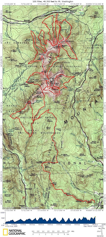
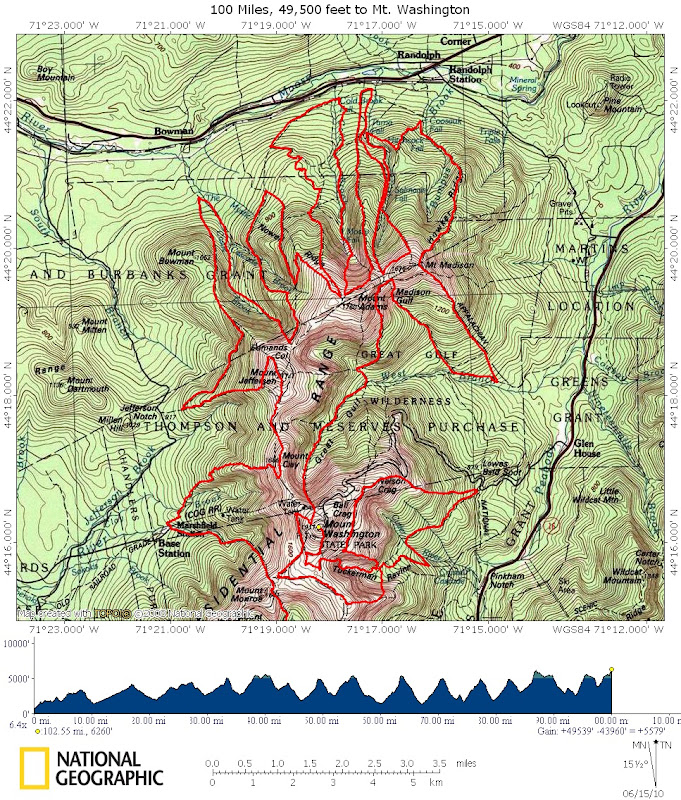
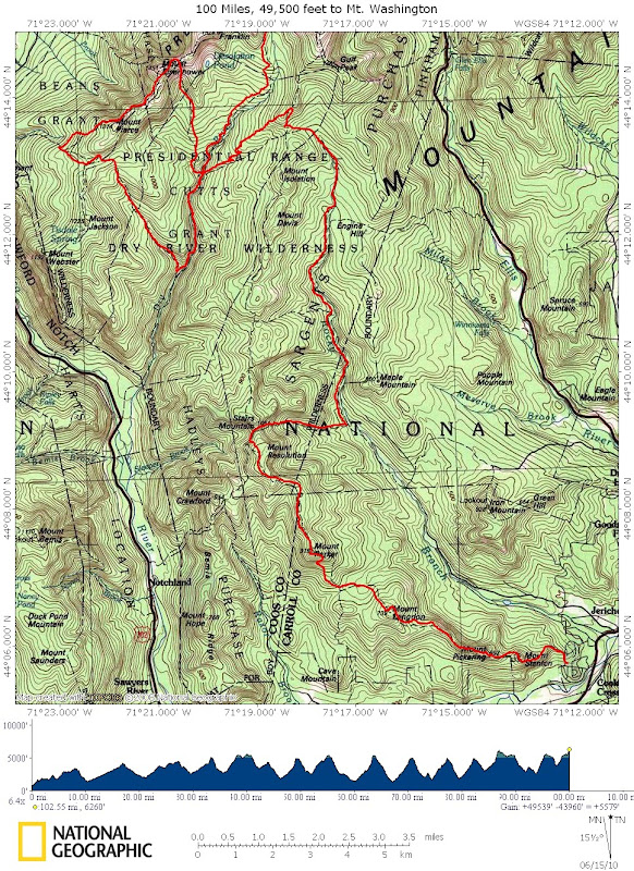
As much as most of us like Jefferson more than Washington as a summit, I think that this ultra event would be better branded if ending on Washington...

Or, we should end it on Isolation, one of the least of the 4Ks ;)

Can I return to a jct if I don't cross / repeat? I.e., a bowtie loop is OK, but not a figure-8? This would allow for the huts to function as support/aid stations.

If you just want a 100 mile route w/ no road crossings that ends on Washington - that wouldn't be hard to do.

Tim
 
Last edited:
OK, Here it is: 100 miles and 49,500 feet, finishing on Mt. Washington. I have the .tpo (NG TOPO 4.5) if you want it (ask).

Here's the whole map:

100-49500-Washington.JPG


North half:
100-49500-Washington-N.JPG


South half:
100-49500-Washington-S.JPG


Enjoy,

Tim
 
Looks great, Tim. You need to give this monster a name now. Who will be the first fore-runner for the epic adventure? Probably a harder route than a double hut to hut (less mileage but more elevation gain).
 
Alas, Ryan (Farmer) has left the country. Book time, if you can call it that, is about 75 hours. Is it doable by the ultra crowd in less than 24 hours (4+ MPH)?

I think, if you really wanted to have an "event" with real participants, prize money, and possibly spectators (does anyone have an attention span that long?) this is not an ideal route. There are several segments which are on questionable trails with questionable footbeds and maintenance histories. It would increase the appeal, I think, if it actually included all the summits along the way.

Tim
 
Farmer's Delight! :D ;)

Tim's Traverse! :p

100 Miles in the Pressies!

Century Walk to Big George!

Up and Down and Up and Down and Up and Down and...

The Ultimate Mt. Washington Hike!

Rolling Around the Rock Pile!
 
OK, Here it is: 100 miles and 49,500 feet, finishing on Mt. Washington.

Dr. D needs to clarify to what extent crossing parking lots is legal. This occurs on your route on Tuckerman Ravine Trail near summit and at Marshfield Station between Ammo and Jewell for example. Otherwise you could still end at Mt Washington by using Westside and Cornice to reach Caps Ridge and do the northern Presidentials in the opposite direction from your original route, then go from top of Great Gulf Trail to summit via Trinity Heights Connector.

I think I would also be tempted to disallow bow-ties reaching the same point twice. For instance, most people would consider it duplication to cross the Castle Trail on The Link, then loop around and cross The Link on the Castle Trail. But coming into that point on The Link, turning on Castle Trail, looping around to come in the other way on The Link, then turning the other way on Castle Trail is just another way to make a closed loop to the same point and should also be disallowed even though with snowshoes you could prove you didn't actually touch the same point.

The AMC map does show the Saco River Trail so it's legal for this game - if your mapping software doesn't allow you to add routes the adjacent highway is of similar length. The AMC map also shows the Presidential Range Rail Trail which would add an easy 4 mile loop.
 
Yeah, well since this variation was for panache for the ultra runners, I figured they wouldn't mind crossing a parking lot full of boyfriend/girlfriend/husband/wife type cheering for them right at the end.

I am pretty sure that I do not return to the same spot (bow tie) - I checked the loop on both TOPO and on Map Adventures. And yes I saw the additions you mentioned, but I wanted to come out as close to exactly 100 miles as I could. Obviously without a wheel or a GPS we'll never know exactly how long this trip is. Even if we can add up the segments, there will be plenty of rounding errors. It's not really clear on the map when you are at a bow tie or not. I know some places (from hiking) that look like bow ties but are actually a few dozen paces apart.

Tim
 
Last edited:
Book time, if you can call it that, is about 75 hours. Is it doable by the ultra crowd in less than 24 hours (4+ MPH)?

Normally I try not to be a naysayer, but in this case I say ABSOLUTELY NOT!! :eek:

For comparison's sake, after Barkley, the Hardrock 100 in Colorado's San Juan Mtns. is considered by most to be the hardest 100 mile ultra race in the country. It has about 33,000 feet of total climb with altitude ranging from roughly 9,000 to just over 14,000 feet on Handies Peak; however, the footing is better than that in the Presidentials. Exactly one person has broken 24 hours, and he (Kyle Skaggs) is another of the "potential human" variety. :D

So no, I don't think it can be done in under 24 hours... but it CAN be done.

I like the route, though -- nice job, Tim!!
 
My personal longest NH hike to a 4K peak.

It doesn't fit the rule of using only trails in the White Mountain Guide, but the longest hike I have ever done in New Hampshire to a 4K peak was about 100 miles. I started at the Canadian Border and hiked the Cohos trail. The first 4K peak I reached was Cabot.
 
so I leave for a little while and people start coming up with these awesome routes. Tim your route makes my first 100 that i'm running in july with 6300 meters of climbing sound like it will be really easy. I had an idea for an interesting way to do the 48 from lincoln woods in 8 seperate linear "runs" without repeating any summits. For example up osseo across franconia ridge over to cannon and kinsmans and on to the moose. Maybe even spot a bike at ravine lodge and ride back for giggles. Or the owls head, cabot and waumbeck route is sure to be a treat.

I'm thinking that the 100 mile whites route could be done in the 30 to 33 hour range. Go for it Jigger!!!
 
Top