
Vose Spur (3862) [70/100] Signal Ridge Trail, Carrigain Notch Trail, Bushwhack, Signal Ridge Trail, ~12 miles, ~3600', 7:45
19-Sep-2010
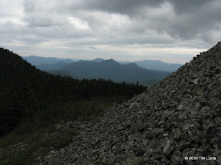
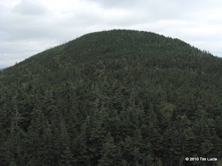
I met Marc at the Signal Ridge Trail off Sawyer Road. We struck off for the junction with Carrigain Notch Trail and used the nearly level and quite wide trail to catch up. The stream crossings were as insignificant as they possibly could be. In fact the trip along Whiteface Brook was quieter and less muddy than in August 2008. Bearing right onto Carrigain Notch Trail and over Carrigain Brook, we continued on until we reached "the boulder" where most people typically begin the bushwhack. The strategy is to follow whatever herd paths or drainages ascend WSW to a distinct ridge line (which is detectable on topo maps, but is much more obvious once there) and then follow this ridge line NW to a talus field, and thence to the summit of Vose Spur. Beyond the talus field is a very steep section of cliffs, which was negtioable with caution.
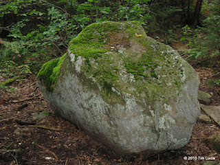
Bushwhack Boulder on Carrigain Notch Trail / Tim on talus Field with Signal Ridge behind
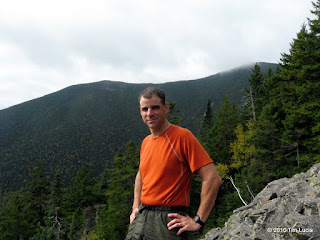
We continued ascending, staying on the highest part of the ridge, and never really needing a map or compass, as there was a herd path to follow for the most part. Marc let me lead the whole way to Vose Spur and I really didn't have any trouble. The second part of the trip involved continuing on to Carrigain, which was new ground for Marc as well. There is another cool talus field just on the Carrigain side of the col, and it offers nice views to the west of Bond, Twins, Hale, Willey Range, and onto the Presidentials (a lot of which had cloud cover today) and to the east of Tremont, Bear and Chocorua.
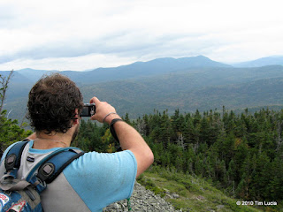
Marc, Willey Range / View to Tremont, Bear, Chocorua
Continuing beyond this talus field, there was a very faint foot path which showed signs of recent travel. The woods were fairly nice, but definitely thicker than ascending Vose from the notch side. Although steep at first, things leveled off on the 4266' unnamed shoulder. From there it was a much more gentle ascent to a beautiful lookout covered in alpine vegetation. The final 150 feet of vertical was the thickest part so far. We may have been better circling to the north to pick up the Desolation Trail. As we got closer, we heard voices and barking. It turned out to be Farmer and Sasquatch, his son, and their dogs. We had just missed LRiz and Adam.
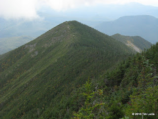
Vose Spur from the col with Carrigain / Signal Ridge from shoulder of Carrigain (150' below the tower)
All Photos
Tim
19-Sep-2010
I met Marc at the Signal Ridge Trail off Sawyer Road. We struck off for the junction with Carrigain Notch Trail and used the nearly level and quite wide trail to catch up. The stream crossings were as insignificant as they possibly could be. In fact the trip along Whiteface Brook was quieter and less muddy than in August 2008. Bearing right onto Carrigain Notch Trail and over Carrigain Brook, we continued on until we reached "the boulder" where most people typically begin the bushwhack. The strategy is to follow whatever herd paths or drainages ascend WSW to a distinct ridge line (which is detectable on topo maps, but is much more obvious once there) and then follow this ridge line NW to a talus field, and thence to the summit of Vose Spur. Beyond the talus field is a very steep section of cliffs, which was negtioable with caution.
Bushwhack Boulder on Carrigain Notch Trail / Tim on talus Field with Signal Ridge behind
We continued ascending, staying on the highest part of the ridge, and never really needing a map or compass, as there was a herd path to follow for the most part. Marc let me lead the whole way to Vose Spur and I really didn't have any trouble. The second part of the trip involved continuing on to Carrigain, which was new ground for Marc as well. There is another cool talus field just on the Carrigain side of the col, and it offers nice views to the west of Bond, Twins, Hale, Willey Range, and onto the Presidentials (a lot of which had cloud cover today) and to the east of Tremont, Bear and Chocorua.
Marc, Willey Range / View to Tremont, Bear, Chocorua
Continuing beyond this talus field, there was a very faint foot path which showed signs of recent travel. The woods were fairly nice, but definitely thicker than ascending Vose from the notch side. Although steep at first, things leveled off on the 4266' unnamed shoulder. From there it was a much more gentle ascent to a beautiful lookout covered in alpine vegetation. The final 150 feet of vertical was the thickest part so far. We may have been better circling to the north to pick up the Desolation Trail. As we got closer, we heard voices and barking. It turned out to be Farmer and Sasquatch, his son, and their dogs. We had just missed LRiz and Adam.
Vose Spur from the col with Carrigain / Signal Ridge from shoulder of Carrigain (150' below the tower)
All Photos
Tim