Brian02108
New member
- Joined
- Sep 13, 2013
- Messages
- 25
- Reaction score
- 0
Had some unfinished business on this one...I had a successful summit of Vose back on May 26, 2013, but didn't continue to Carrigain, as overcast skies combined with all of the unexpected snow on the ground and trees, left me pretty wet and cold. I didn't have the best shoes for snow or an extra set of gloves, so I skipped Carrigain with a vow to return soon.
The weather report called for clear, sunny skies on Saturday, turning into rain late afternoon followed by rain all day Sunday. The initial plan was to hit Vose, Carrigain, head down Desolation then find a nice backcountry camp site off of Shoal Pond Trail or Thoreau Falls trail, depending on time. As usual, the bushwhack took longer than anticipated, so the plans changed.
Was a little nervous driving up 93 since most of the trip from Concord to the Notch was fogged in. Where are those clear skies?? Made a stop at Lincoln and still no sign of any clearing. Thankfully, once I got through the Notch and made my way to Twin Mountain, the skies magically opened up and clear skis could be seen for miles. Got to Sawyer River Road and was on the Signal Ridge Trail by 7:30. Parking lot was fairly empty. This trek was surprisingly dry, usually there is much more mud to deal with, but the past few days were rain-free. Hit the junction with Carrigain Notch trail and continued to the "bushwhack boulder".
Took a break at the boulder before starting the bushwhack up to Vose. The herd path soon disappeared and the adventure begins! I had some waypoints from the last time I was here in May, and the going was pretty painless with relatively minor patches of dense forest. It's always nice to see patches of bright sunshine poking through up ahead.
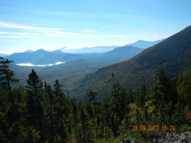
Before long I had locked onto another herd path headed to the talus field. Some blowdowns required some diversions, but not too bad overall. Hitting the bottom of that talus field is a great feeling. Last time everything was fogged in, so the views I got today were simply amazing. Some great views of clouds lingering in the valleys with the sun shining brightly on the mountains.
http://imgur.com/IxWUzqC
After another break at the top of the talus field, it was time to push on to the summit. There really is no clear re-entry point into the woods, so you just pick a spot and "bust through". The trek was a little steep for a while, but nothing too challenging. Just a slow, methodical slog up the slope. Soon, things leveled off and the woods opened up. Linked up with another herd path and soon after reached the summit. Glad to see the chair was still there. Took a little break, then grabbed the log book out of the PVC pipe. Found my old entry from May then flipped forward. There were about 10 visits to the summit since I was last here, so about 2-3 groups per month have been here since May. Saw one hiker had come from Carrigain and I was ready to go the opposite way. I left Vose and headed to a waypoint near another talus field some folks had mentioned on some trip reports. The forest was thick and the going was slow, but I have definitely been through worse.
I eventually hit the second remote talus field of the day on the way to Carrigain. What a feeling! Not many people have been here, that's for sure. Again amazing views and a great spot for a break. I could have stayed there for hours, but Carrigain was calling.
http://imgur.com/liBSFIM
http://imgur.com/LVTiMdn
The remainder of the bushwhack was a thick, dense journey until the summit was close. I ended up traversing around the left side of the slope heading to Carrigain, got some great views of Mount Lowell.
http://imgur.com/yRbjUr7
(Next time I'm going to hit the highest point after the second talus field and make a beeline for the summit). Looking back at my trek, I was probably between 250-400 feet from the highest point of elevation during a majority of this trek from Vose to Carrigain. Soon I could see the Signal Ridge trail ahead and knew the summit was close.
http://imgur.com/1nvrvo5
Kept climbing some steep spots and the ground finally leveled off and the woods opened up a bit. Spotted a herd path and before long, I'm at the fire tower. Success!!!!
The weather had changed since the morning, as many dark clouds were gathering and the wind at the summit was pretty strong, probably reaching 40 mph...got some great photos and video from the tower.
http://imgur.com/G3yl0ZE
http://imgur.com/vucZ53R
I made an audible to skip the overnight camping, as the rain was already starting to fall lightly. I had 5 miles back to the trailhead and less than 2 hours of daylight, but after you spend all day bushwhacking, taking a trail is a piece of cake.
Had the headlamp ready to go, but made it back to the car right at sunset. Did not see a soul on the trails the entire day, but I did hear some folks when I was about 1/2 mile from Carrigain on my bushwhack (it's amazing how quiet the woods can be and how far sound can travel).
Just a great trip that ended up being around 12 miles.
The weather report called for clear, sunny skies on Saturday, turning into rain late afternoon followed by rain all day Sunday. The initial plan was to hit Vose, Carrigain, head down Desolation then find a nice backcountry camp site off of Shoal Pond Trail or Thoreau Falls trail, depending on time. As usual, the bushwhack took longer than anticipated, so the plans changed.
Was a little nervous driving up 93 since most of the trip from Concord to the Notch was fogged in. Where are those clear skies?? Made a stop at Lincoln and still no sign of any clearing. Thankfully, once I got through the Notch and made my way to Twin Mountain, the skies magically opened up and clear skis could be seen for miles. Got to Sawyer River Road and was on the Signal Ridge Trail by 7:30. Parking lot was fairly empty. This trek was surprisingly dry, usually there is much more mud to deal with, but the past few days were rain-free. Hit the junction with Carrigain Notch trail and continued to the "bushwhack boulder".
Took a break at the boulder before starting the bushwhack up to Vose. The herd path soon disappeared and the adventure begins! I had some waypoints from the last time I was here in May, and the going was pretty painless with relatively minor patches of dense forest. It's always nice to see patches of bright sunshine poking through up ahead.
Before long I had locked onto another herd path headed to the talus field. Some blowdowns required some diversions, but not too bad overall. Hitting the bottom of that talus field is a great feeling. Last time everything was fogged in, so the views I got today were simply amazing. Some great views of clouds lingering in the valleys with the sun shining brightly on the mountains.
http://imgur.com/IxWUzqC
After another break at the top of the talus field, it was time to push on to the summit. There really is no clear re-entry point into the woods, so you just pick a spot and "bust through". The trek was a little steep for a while, but nothing too challenging. Just a slow, methodical slog up the slope. Soon, things leveled off and the woods opened up. Linked up with another herd path and soon after reached the summit. Glad to see the chair was still there. Took a little break, then grabbed the log book out of the PVC pipe. Found my old entry from May then flipped forward. There were about 10 visits to the summit since I was last here, so about 2-3 groups per month have been here since May. Saw one hiker had come from Carrigain and I was ready to go the opposite way. I left Vose and headed to a waypoint near another talus field some folks had mentioned on some trip reports. The forest was thick and the going was slow, but I have definitely been through worse.
I eventually hit the second remote talus field of the day on the way to Carrigain. What a feeling! Not many people have been here, that's for sure. Again amazing views and a great spot for a break. I could have stayed there for hours, but Carrigain was calling.
http://imgur.com/liBSFIM
http://imgur.com/LVTiMdn
The remainder of the bushwhack was a thick, dense journey until the summit was close. I ended up traversing around the left side of the slope heading to Carrigain, got some great views of Mount Lowell.
http://imgur.com/yRbjUr7
(Next time I'm going to hit the highest point after the second talus field and make a beeline for the summit). Looking back at my trek, I was probably between 250-400 feet from the highest point of elevation during a majority of this trek from Vose to Carrigain. Soon I could see the Signal Ridge trail ahead and knew the summit was close.
http://imgur.com/1nvrvo5
Kept climbing some steep spots and the ground finally leveled off and the woods opened up a bit. Spotted a herd path and before long, I'm at the fire tower. Success!!!!
The weather had changed since the morning, as many dark clouds were gathering and the wind at the summit was pretty strong, probably reaching 40 mph...got some great photos and video from the tower.
http://imgur.com/G3yl0ZE
http://imgur.com/vucZ53R
I made an audible to skip the overnight camping, as the rain was already starting to fall lightly. I had 5 miles back to the trailhead and less than 2 hours of daylight, but after you spend all day bushwhacking, taking a trail is a piece of cake.
Had the headlamp ready to go, but made it back to the car right at sunset. Did not see a soul on the trails the entire day, but I did hear some folks when I was about 1/2 mile from Carrigain on my bushwhack (it's amazing how quiet the woods can be and how far sound can travel).
Just a great trip that ended up being around 12 miles.
Last edited: