Chimney Pond Baxter Trip 3/1-3/6

vftt.org

Help Support vftt.org:

This site may earn a commission from merchant affiliate links, including eBay, Amazon, and others.

giggy

New member
Joined
Nov 18, 2004
Messages
2,581
Reaction score
481
Location
Hikin' the scree on Shasta....
Players:

Jenn (NIF)
Doug (Cbcbd)
Jeff (Jeff)
Lloyd (Hamtero)
Arm (Arm)
David (Woody48)
Alan (Alan)
Guy (Giggy)

Day 0

We all meet in Millinocket Friday night arriving at different times. Doug is the last to arrive coming from Stamford, CT. And where do we tell him to meet us? The one and only La Casa for some fine dining. Trip starts off good with some good team building exercises Friday night.

Day 1

Winter Storm Warning for Baxter State Park.

Snow 10-16 inches for Millinocket on top of the 10 to 18 they got the Wednesday before. Yep - was expecting a nice long snow slog for 12 miles to Roaring Brook.

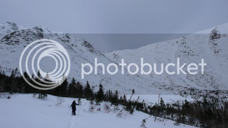
The trek to Chimney Pond is 16 miles, but Baxter State Park requires a one night stay at Roaring Brook which is about a 12 mile hike in. We start the 12 miles trek in about 9am. We started in heavy snow and end in heavy snow! We all had probably a good 80 pounds of gear with climbing gear, pickets, screws, ice tools, mountaineering axes, biners, slings, camping gear, food for 6 days and of course – a nice mix of hops and barley and other pleasures.

While I can’t speak for all of us, I thought it was a tough (physically and mentally) arse trek in hauling the gear and dealing with weather. In fact, it was one of the toughest 12 mile days I ever had. Arm has been there many times and he thought it was the worst conditions he has ever seen for the trek in. As the snow got deeper, the sled became much heavier, etc….

After a couple of hours, we were pretty wet and frozen from all the precip coming down and the road appeared featureless due to snow and there was no way to know how far one had went or how far there was to go. Mentally, this started to play havoc in my head.


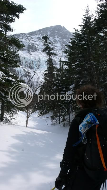
Near the end, I had no clue if I had 5 miles to go or .5 miles. My AMC map didn’t have Bear Brook camping site and still had avalanche field - so when I arrived at bear camping site - didn’t know how far up the road I was - and when I passed Katahdin lake site (which was the former Avalanche Field site, but didn’t know it at the time), I still thought I had at least a 3 to 5 miles left. Turns out, it was roughly 1.5 miles from here. But then your head starts to play games - you know your on the right road, but you think – did I take a wrong turn somewhere??– this stuff isn’t on map! If it was bluebird, you can see the peak on your left and can tell you’re obviously right – but when visibility is very low and you’re alone, the mind can play tricks!

http://www.flickr.com/photos/dawoodford/2317798458/in/set-72157604069481233/


Later at Chimney Pond, the ranger says - well when conditions are good, the sled haul is pleasant but these are not those conditions. But at the end of the day, it was ok and looking back, quite fun.

Jeff, Lloyd and I are the first to arrive to Roaring Brook bunkhouse about 5pm and we get the stove going and get the cabin prepared for everyone else. Shortly after the rest arrive. Once we get warm, fed and hydrated, everyone is talking about the trek in - pretty much everyone was solo for the entire day moving at their own pace, and just getting it done. We are all pretty glad to be warm, dry, eating and resting after the trek in.

Note Dougs Frosty goat
http://outdoors.webshots.com/photo/2553467780100331463ThwBrr


cont....
 
Last edited:
Day 2

We woke up about 6am and it’s still snowing and dropped another few inches overnight and the winds are absolutely howling. We have to go about 3.3 miles up to Chimney Pond today but the vertical is about 1500 feet. Tougher than it seems hauling the sleds – especially on the steeper parts. About 8 or 9am, the skies open up, the snow stops and the sun comes out and is in and out of the clouds the rest of the day. Besides the cranking wind, it’s a beautiful day. Not that cold – maybe around 20. So we saddle up about 11am and make our way up the Chimney Pond. It goes rather quick, but still a tough 3.3 miles hike with the sled and loose snow – we all get blasted coming across Basin Pond.

http://www.flickr.com/photos/dawoodford/2317797720/in/set-72157604069481233/

The trail was broken by a party heading out from Chimney Pond as well as the ranger snowmobile but the winds drifted lots of snow back over the broken trail – but it helped us nonetheless. The views just keep getting better and better and better and even better!

http://outdoors.webshots.com/photo/2447054460100331463PSLAbH

We finally start filtering in to Chimney Pond about 3pm. The new bunkhouse rules!! It still has the “new house smell” it’s nice and warm due to party that left in the AM. Everyone sets up shop relaxes and enjoyed the views of the knife edge, Baxter headwall and Pamola ice cliffs. There is nothing like this anywhere in the northeast that I have seen. This is like Huntington ravine and Tuckerman Ravine times 1000. I was able to summit Baxter peak last winter via Abol Slide and this side of the peak is much more rugged and beautiful. I am in love with what I see and I am also crapping my pants after seeing the routes up close. Some of us were looking to climb the Chimney Route and others the Cilley Barber or Chauvin-Cole. Even the strongest climbers of our party and looking at the headwall going… “those routes are freaking long, steep and very technical looking”….. they look twice as long as anything in Huntington Ravine and steeper. Not looking forward to spending 2000 vertical feet on my calves and frontpointing! But we know our plans are likely going to change due to snow loading due to wind and the ranger confirms this very quick basically saying don’t climb anywhere near the headwall as its about bad as it gets as far as avalanche conditions. We figure there are really only 2 safe ways to the summit for the next couple days. Either the Dudley Trail up to Pamola Peak or Cathedral Ridge to Baxter Peak. We are all pretty beat and Monday’s weather is going to suck with high winds and low clouds so we decide to either ski and/or ice climb off Pamola.

http://outdoors.webshots.com/photo/2230280770100331463zEXtSO

http://www.flickr.com/photos/dawoodford/2317801528/in/set-72157604069481233/

Does the view get better than this??

http://www.flickr.com/photos/dawoodford/2316992739/in/set-72157604069481233/


http://www.flickr.com/photos/dawoodford/2317788628/in/set-72157604069481233/


Day 3

After a great night sleep, we get up slowly, eat brew coffee and tea - and Jen and Doug go ski the lower Saddle trail and the rest of us head off to the the side of Pamola to do some easy ice climbing.

http://www.flickr.com/photos/dawoodford/2316985615/in/set-72157604069481233/

After a couple of hours, the wind picks big time up and snow blasting us and gets quite unpleasant, so we call it a day about 3pm.

http://www.flickr.com/photos/dawoodford/2316984261/in/set-72157604069481233/

Doug and Jeff go and tackle mini pinnacle #2.

http://outdoors.webshots.com/photo/2590268140100331463GWzDvg

The one thing I noticed about Baxter is really how fast the weather changes up there - I have seen weather change fast in the Presidentials, but in Baxter, your views are limited regarding oncoming weather due to being in basically an amphitheater and all of sudden the winds crank and visibility gets very low – quick.

cont....
 
Last edited:
Day 4

This is the summit day, it’s not great out but the best we got. Winds are still cranking and the last 1000 feet of the peak are socked in – but it’s better than Monday and Wednesday is a red day already with another winter’s storm warning. Red Day is when the ranger basically makes you stay in the cabin and your forbidden to head above treeline – which the cabin is basically at treeline. We choose Cathedral Ridge with the option to maybe do the knife edge is it looks OK up high. Cathedral Ridge is about 1.6 miles and 2200 vertical to the summit from Chimney Pond most of that vertical comes in a about a .7 miles stint. - Don’t let the short distance fool you - it’s a challenge. Jen, Woody and Alan hiked to the base of the ridge and deciding today wasn’t the day for the summit. To be honest, I was feeling we would get partway up the ridge and weather would turn us back and join them back at bunkhouse.

http://www.flickr.com/photos/dawoodford/2316995167/in/set-72157604069481233/

http://outdoors.webshots.com/photo/2159646060100331463tCvDmv

http://outdoors.webshots.com/photo/2093223720100331463nJMibp

We routefind to the climbers right around the first Cathedral to avoid a very avalanche prone snowfield that looks like it slid recently. No need to take a chance, we just climb around it and regain the ridge between the 1st and 2nd Cathedrals. Its steep (hiking steep, not climbing steep, probably class 3 rock) rock and ice from to the top of the ridge. Somewhere around the 2nd Cathedral the cloud level drops and winds pick up and it’s totally socked in with pretty high winds and higher gusts and then the goggles fog and freeze and the .5 miles to the summit become “interesting”. We were able to find some shelter from the wind on the summit. The savoir from the wind was it wasn’t that cold.

http://outdoors.webshots.com/photo/2438974030100331463VDrgMH

So we summit around noon and the debate starts about the Knife edge. I really had enough fighting the wind, foggy frozen goggles and low visibility. The knife edge was doable, but personally I wanted nothing to do with it on this day. Arm didn’t care if he went across or went down, so he decided to come down me while Doug, Jeff and Lloyd went for it. Baxter doesn’t allow solo folks above treeline, so he came down with me– thanks a million Arm. I pussed out on the Knife edge, but I will be back to cross it next winter. Trek down Cathedral ridge was pretty straightforward just quite steep and required care downclimbing, but nothing too dicey. The 1000 foot drop-off to your right down numerous gullies - gets your attention thought. Not a place to slip. Doug, Lloyd and Jeff had a great hike over the knife edge because about 30 min after we separated the cloud layer lifted and the entire mountain was in the clear. Maybe one of them can post their experience on the Knife Edge.

I didn’t think we would summit at all due to weather and conditions so the summit was a really a bonus to this trip.

Day 5

Winter Storm Warning Part 2. Lloyd is going to Denali in May so we did some Z-pulley set ups beneath Pamolo ice cliffs. I know the Z-pulley pretty well know for doing a few glacier climbs in the Cascades so ran through that couple of times and then we ran a running belay up below Pamola Ice cliffs showing Lloyd how to clip by anchors, etc.. .

Doug went and climbed one of the Grade 4 pillars while Jen belay slaved him. (no easy task for Jen in that weather!!) It was torture for him to stare at Cilley Barber for 4 days and not climb it. I am just glad I get to say I know Doug when he goes off to climb really big things!! This guy can climb.

Day 6

Up at 4:30am for the 16 mile haul out and we are treated to a bluebird and basically windless day and I am just like “you have got to be shitting me” - We hit the trail about 6am and most are back at the cars by about 2pm. The great weather made the hike out awesome – it was not a slog for me – just a nice hike out and not too bad with the sled going down not being pulled up!

Simply a great trip with many laughs and awesome sights - I think for any climbers, getting into Chimney Pond in winter for the first time is like a kid in a candy store. It just doesn’t get more alpine than this in the northeast. The weather wasn’t ideal, but I now know that any day in Baxter is a good day. One benefit of being up there in bad weather is experiencing the before, during and after of storms. The quickness they arrive, the storm and then the cranking winds (pounding the bunkhouse) as the low departs and then finally the calm after it departs. Very cool.

Saw some deer on the way out and a pine marten at chimney pond - other than that not much wildlife sightings, I was sure I would see some moose, but we didn’t.

How - I have overlooked this gem for the past 8 winters is inexcusable. When invited on trips the last couple of years I really should have scrapped other plans to head into a Baxter. The regulations, the permits, the hassle, all worth every minute. Something about having an entire mountain like this to yourself that makes it all worth it. It has become my favorite place in the northeast.

Thanks to all the easy going friends that came along and made a trip like this fun – need fun when weather isn’t ideal. Thanks especially to Arm who made the drive to Millinocket in November, slept in his car, and then secured the permit for a March weekend. The trip made my winter.

Enjoy the pix!

Woody's Pix
http://www.flickr.com/photos/dawoodford/sets/72157604069481233/

Arms Pix

http://outdoors.webshots.com/album/561151118meVwfM


I am sure others will add comments and pix...
 
Last edited:
Giggy - that is one fantastic TR. Was looking forward to reading this and it greatly exceeded my expectations. An amazing adventure for sure. I agree with you completely with your sentiments about Baxter :D

Great pix by Arm and Woody, too. Arm's video clip of you ascending the Cathedrals was incredible :cool:

Great job everyone.

Thanks
Marty
 
Wow!!!!

I posted my pics here:
http://sports.webshots.com/album/562746300zNdlXj

I'll have some videos coming up also.

Ok, I think Giggy said it all and very well. I will second - this is now my favorite playground in the Northeast!! My second time in Baxter, my second time complaining about regulations/red tape, my second time completely forgetting it all when I'm there and thinking that it was well worth it and just HURTING to go back! I cannot thank Arm enough for getting it all going and organized.
NOTHING like this in the Northeast. If you haven't gone, go!

ok, here is some side trip stuff

Day 3:
The ranger finds us skiers and highly recommends for us to go up the Saddle trail to treeline and take a right into the Saddle Brook drainage, following it all the way down to the intersection with the Chimney pond trail.
2065959560064115915lYEKXf_fs.jpg

Well, almost 2' of new snow was great, we make a nice track up the Saddle trail, drool at all the snow loaded gullies waiting to be skied and drop into the drainage... well, 2' of powder needs steepness to get moving, which we didn't have. We slogged all the way down the drainage, making maybe one turn the whole way down. We then headed up the saddle some more and skied around the trail, which actually had some pitch to it. Anyway, that was it... enjoy the nice broken out track up, Ranger Rob :rolleyes: :)
Note to skiers: don't ski the drainage with more than 6" of snow on it, you won't go anywhere
2683386370064115915kFvDwj_fs.jpg


Day 4:
Summit day. After we reach the summit with Arm and Giggy, Jeff, Lloyd and I decide to head for the Knife Edge and down the Dudley. The winds coming up from the Chimney side are pretty intense. Some spots have us on all fours getting across and we try our best to stick to the right (lee) side of the ridge. Looking over the edge of the ridge was like sticking your head in a wind tunnel.
2134500670064115915VqCGVD_fs.jpg


The infamous rock step could actually be skirted by going down a nice windblown snow ramp left of it.
2968789610064115915HNZquo_fs.jpg

The going is steady and deliberate and we make it across the Edge in 2 hours, putting us on top of Pamola ~3pm.
This is where the fun began...
Some ways down the bouldery and rocky Dudley the trail just sort of disappears under some snow. Left, right, straight... who knows. I guess left and we sort of keep going that way figuring the sharp left turn in the trail was near. Since I was pretty sure the trail had gone to the left I discuss with Jeff that I think we should keep going to the left and we'll hit the trail. Well, we peer over the boulders and can see the cabin but no blazes. I spy a short brushy snow gully which looks like it ends in a small possible cliff and onto the slope directly left of the Chimney Pond area and left of the ice cliffs. Jeff has his 30m rope with him and so I go down to check out the cliff. I find a tree slung with some stuff and also a nice rock which we could rappel off of. I call Jeff and Lloyd down and let them know I found an anchor. I then proceed to screw up the uncoiling and now spend what seems like endless minutes trying to untangle the rope. Meanwhile Jeff already has base camp on the walkie talkie and they're chatting back and forth with us now. I finally get it untangled after frustrating minutes all around, sling the rock, clip a biner and setup to lower. Lloyd is lowered first (don't tell his wife) and Jeff second. I am running out of patience and leave the sling and biner there and rappel after them down a nice rock face to ice runnel/bulge.

http://outdoors.webshots.com/photo/2409816690100331463SwEvaK

Pull the rope and now we're home free. Slog down the easy slope with directions from the walkie talkie to "go more right" and "you're 20" from where you were yesterday". Returned close to 6pm I think. Longest 4 miles I've done, I think.
Excellent adventure.

I do have to thank Jen for all her belays- a real trooper. First on the very wet Mini Pinnacle #2 and then on South of the Border during a mixed precip day - it was a colder and windy day. But I have to admit, one of the coolest mountain moments I had during the trip was being ~10ft up the first almost-vertical first pillar of SotB trying to swing my left tool into the ice when I get showered by a blast of ice pellets from above. Don't know why I found being blasted in the face with freezing rain enjoyable, but it was definitively a rush I'll remember! :D
 
Last edited:
good TR !

The most I've ever seen you write. Wish I was there...
 
Once you get into the park it doesn't take long to notice this place is like no other.
Red tape and permit hassles are quickly forgotten as a different kind of awareness creeps in.
Great story!!
 
  • Like
Reactions: arm
Great TR, Giggy, and a great trip for all of you from the sound of it (haven't checked out the photos yet). Katahdin truly is a gem--every time I think of it I give a little thanks to Gov. Baxter for having the foresight and generosity to protect it for us.

You're certainly right about not letting the short distance from Chimney Pond to the summit fool you. In the winter it's a bear, especially with the route you chose (or, should I say, the conditions chose for you). :cool:

But that mountain sure has a way of making the long slog from Abol Bridge worthwhile!
 
Sounds like a grand trip you guys had, makes for very fond memories. Doesn’t sound like a stroll in the park to Roaring Brook that day. Dealing with a 80 pound sled in unbroken snow, must have been pulling the sled even going downhill. Plus you must have had some weight being carried on your backs. Reading your TR I can just feel how thrilling the trip was for you all.

I think what’s key for a trip to Katahdin via Chimney Pond is having a couple of extra buffer days, insurance in the event of foul weather.
 
Reading the report almost felt like being there!

How do you squeeze more vacation days out of your employer?
 
Great mountaineering report !

Thank's for sharing it all with us Guy. Your TR is like a reality outdoors show!
 
Sounds like you guys had some fun...

cbcbd said:
The infamous rock step could actually be skirted by going down a nice windblown snow ramp left of it.
Awww! That was my favorite spot on the Knife Edge. When I was there, we had a nice bit of mixed climbing--one hand and foot on ice, the other hand and foot on rock. However, we were smart enough to return via the KE, rather than via Dudley. :) (We had come up via Abol Slide, so Dudley didn't make much sense, anyhow.)

Doug
 
Wow!!! Now that's a winter trip...best winter TR I've ever read in my whole life...

You all are the most awesome. I want to be you.

Jenn, poor you, the only woman with all those really, really cute hot guys!

You all get my vote for the best winter trip in 2008.

Now you guys deserve something special, for all you guys out there that know what I mean!!! :D
 
  • Like
Reactions: arm
Life itself. Lived to the utmost. What a trip, yours for the work and the taking. Great pics and great reporting. Thanks.
 
awesome report gig. i was just looking forward to spring, now i wish winter would stick around long enough for me to earn more vacation time and then go up there. but at the rate i'm using vacation, well, it'll probably -be- next year. :cool:
 
Awesome trip report and pictures! You guys made the most of what you were dealt with weather wise. Good job! That is one of the problems with having to book trips like this 4 months in advance, the weather is always a crapshoot... At least you got a yellow for summit day :)

That is definitely my favorite playground in the NE. You have to go to the Rockies to find anything like it (thanks to the ice age, we are very fortunate to have a mountain like that) :)

Like mtnpa states, you forget all of the permit/regulation hassles once you arrive, and just enjoy the place...
 
Nice pics and report! I can't wait to do that Cathedral/Knife Edge route again, sweet trails. I plan to do it when it is 80 degrees, sunny, and no ice. That sounds like an insane route in winter, I would have hunkered down in the cabin and watched you with a telescope, like Russel Bryce watched his climbers on the Everest show on the Discovery channel. You guys are insane, but in the good way.
 
Top