
1HappyHiker
Well-known member
The “rainbow” mentioned in the title of this Trip Report refers to the Rainbow Trail on the southeast flank of Carter Dome. A 12 mile loop hike involving the Rainbow Trail was done on 16-Sep-2008. The loop began and ended on the Bog Brook trail. Other trails involved in the loop were the following (in the order listed): Wildcat River; Carter-Moriah; Rainbow; Wild River.
This was the first time I’ve ever done this loop, and I was “wowed” by the variety it offered . . . . like a visit to a hut; lakeside views; impressive mountain panoramas; a trek through an awesome birch glade; lots of picturesque brooks.
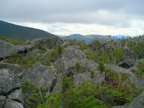
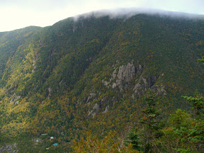
I began the hike at the leisurely hour of 10 AM, and was at the Carter Notch hut about 2 hours later in time to enjoy my lunch sitting on the Rampart. The Hut is in such a unique location in the Whites!! I mean like it’s nestled in a remote col called Carter Notch that’s located between two 4,000-foot mountains, and bordering the Hut are two pristine mountain lakes. And very close-by, there’s that stark field of boulders called the Rampart caused by a massive landslide in the 1800’s. Where else are you going to find something like this?!
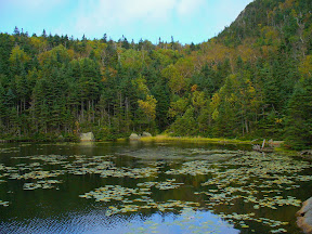
After having lunch at my “5-star” location on the Rampart, I spent some time enjoying the fabulous lakeside views of the Carter Lakes. I lingered there for awhile in hopes that the persistent cloud cover on the high peaks would clear so I could get some better photos. But eventually, I had to give up the wait and start moving if I was going to complete the loop in daylight. I still had several miles to go. (Below are a few photos showing the Rampart, and some lakeside views.)
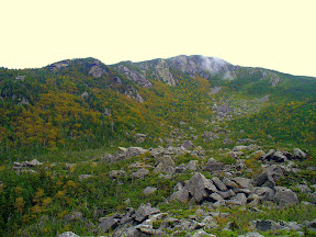
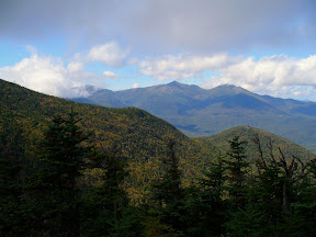
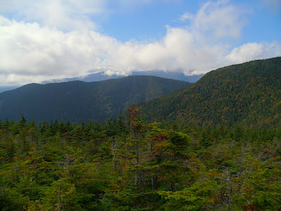
After leaving the Carter Notch area I headed up the Carter-Moriah Trail toward the summit of Carter Dome. Along the ridge leading to the summit, there were spectacular mountain vistas (photos below). However, since the cloud cover came and went very quickly, I had to be speedy with the camera to capture the views.
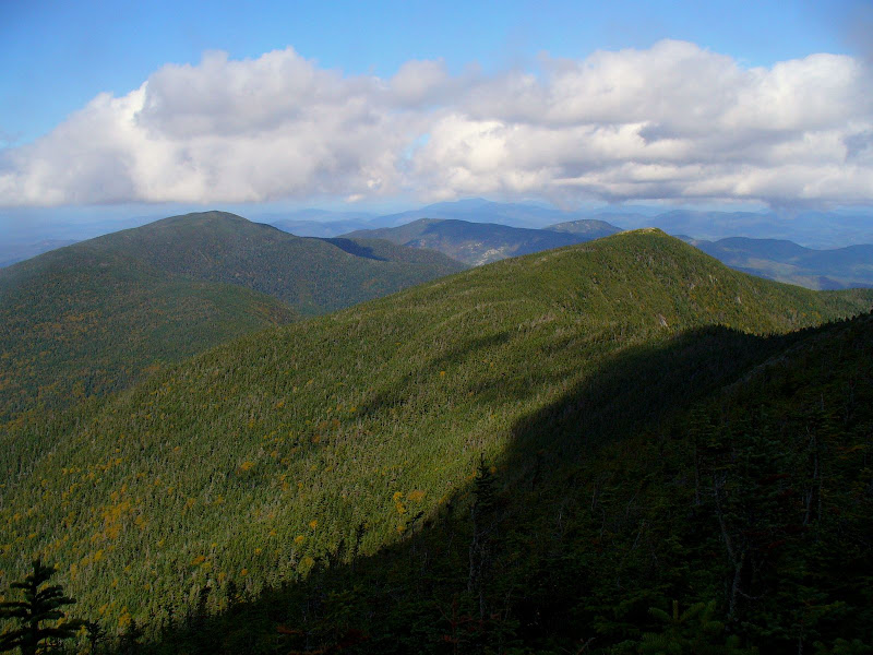
Upon arriving at the summit of Carter Dome, the Presidentials were pretty much socked in again, so I felt fortunate to have gotten a few decent shots on the way up. However, even though the Presidentials were temporarily “closed”, I was treated to a great view looking north along the Carter Range (photo below).
After summiting Carter Dome, I then began the return leg of my loop by descending the Rainbow Trail. This was the first time I’d ever been on this trail and so I was excited about doing something new and different. Although I’d read the WMG description of this trail and looked at the topo map, I was still a bit surprised at how much “down” there is on this trail. (It’s probably a safe bet that going the other direction involves a lot of “up”!) Anyway, none of the “down” was difficult to negotiate, and since the trail is lightly used, it’s not eroded down to rock & roots, and the footing is excellent.
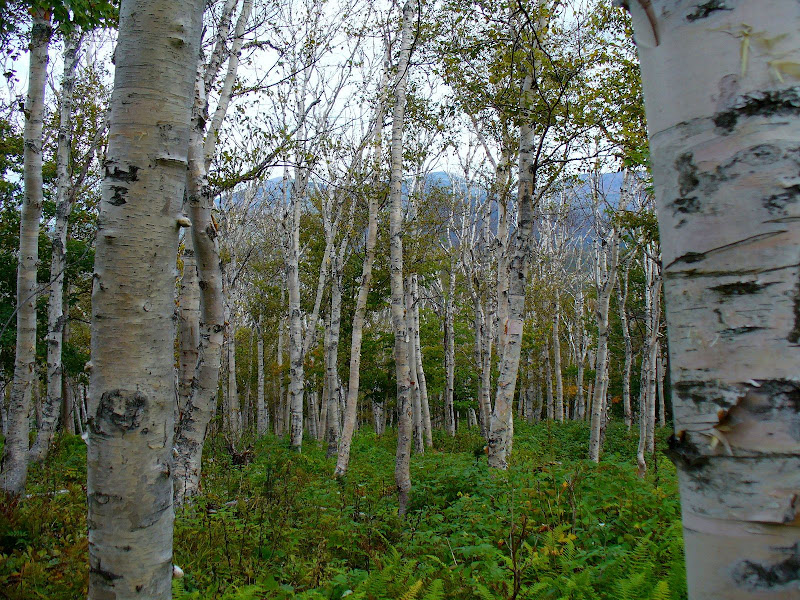
There is one feature of the Rainbow Trail that I think is spectacular, and almost worthy as a destination on its own!! I’m talking about the massive birch glade located toward the Perkins Notch end of the trail (photo below).
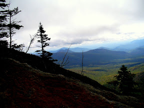
At the upper end of the Rainbow Trail there is an old fire scarred area where there are views of the backside of the Carters, plus other great views to the north, south, east & west. The clouds had drifted in once again when I was at this spot, but below is one photo taken from this location looking west toward the Carter Notch.
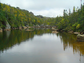
My loop eventually brought me back to the Wildcat River Trail. And although this portion of the trek was a repeat of the ground covered at the beginning of the loop, it was still just as pleasant to amble along the bank of the untamed Wildcat River. I arrived back at the trailhead just shortly before 5:30 PM after spending another great day in the Whites!
There’s one footnote that perhaps should be added to this report. The multiple brook crossings at the beginning of the Bog Brook Trail were doable. However, they were not just a “hop skip & a jump”! Anyone unaccustomed to brook crossings might find them a bit of a challenge. So, to avoid the crossings, there’s always the alternative of taking the gravel logging road (FR 233) to the point where the Bog Brook Trail intersects it.
BOTTOM LINE TO ALL THIS: This was a new loop hike for me, and my expectations were exceeded by the variety it provided in terms of views, terrain, and uniqueness. If you’ve never done this loop (or even if you have), you might want to consider finding a pot of gold by putting a “rainbow” in your hiking plans.
1HappyHiker
This was the first time I’ve ever done this loop, and I was “wowed” by the variety it offered . . . . like a visit to a hut; lakeside views; impressive mountain panoramas; a trek through an awesome birch glade; lots of picturesque brooks.
I began the hike at the leisurely hour of 10 AM, and was at the Carter Notch hut about 2 hours later in time to enjoy my lunch sitting on the Rampart. The Hut is in such a unique location in the Whites!! I mean like it’s nestled in a remote col called Carter Notch that’s located between two 4,000-foot mountains, and bordering the Hut are two pristine mountain lakes. And very close-by, there’s that stark field of boulders called the Rampart caused by a massive landslide in the 1800’s. Where else are you going to find something like this?!
After having lunch at my “5-star” location on the Rampart, I spent some time enjoying the fabulous lakeside views of the Carter Lakes. I lingered there for awhile in hopes that the persistent cloud cover on the high peaks would clear so I could get some better photos. But eventually, I had to give up the wait and start moving if I was going to complete the loop in daylight. I still had several miles to go. (Below are a few photos showing the Rampart, and some lakeside views.)
After leaving the Carter Notch area I headed up the Carter-Moriah Trail toward the summit of Carter Dome. Along the ridge leading to the summit, there were spectacular mountain vistas (photos below). However, since the cloud cover came and went very quickly, I had to be speedy with the camera to capture the views.
Upon arriving at the summit of Carter Dome, the Presidentials were pretty much socked in again, so I felt fortunate to have gotten a few decent shots on the way up. However, even though the Presidentials were temporarily “closed”, I was treated to a great view looking north along the Carter Range (photo below).
After summiting Carter Dome, I then began the return leg of my loop by descending the Rainbow Trail. This was the first time I’d ever been on this trail and so I was excited about doing something new and different. Although I’d read the WMG description of this trail and looked at the topo map, I was still a bit surprised at how much “down” there is on this trail. (It’s probably a safe bet that going the other direction involves a lot of “up”!) Anyway, none of the “down” was difficult to negotiate, and since the trail is lightly used, it’s not eroded down to rock & roots, and the footing is excellent.
There is one feature of the Rainbow Trail that I think is spectacular, and almost worthy as a destination on its own!! I’m talking about the massive birch glade located toward the Perkins Notch end of the trail (photo below).
At the upper end of the Rainbow Trail there is an old fire scarred area where there are views of the backside of the Carters, plus other great views to the north, south, east & west. The clouds had drifted in once again when I was at this spot, but below is one photo taken from this location looking west toward the Carter Notch.
My loop eventually brought me back to the Wildcat River Trail. And although this portion of the trek was a repeat of the ground covered at the beginning of the loop, it was still just as pleasant to amble along the bank of the untamed Wildcat River. I arrived back at the trailhead just shortly before 5:30 PM after spending another great day in the Whites!
There’s one footnote that perhaps should be added to this report. The multiple brook crossings at the beginning of the Bog Brook Trail were doable. However, they were not just a “hop skip & a jump”! Anyone unaccustomed to brook crossings might find them a bit of a challenge. So, to avoid the crossings, there’s always the alternative of taking the gravel logging road (FR 233) to the point where the Bog Brook Trail intersects it.
BOTTOM LINE TO ALL THIS: This was a new loop hike for me, and my expectations were exceeded by the variety it provided in terms of views, terrain, and uniqueness. If you’ve never done this loop (or even if you have), you might want to consider finding a pot of gold by putting a “rainbow” in your hiking plans.
1HappyHiker
Last edited: