Going “Batty” Trying to Avoid the Rain (Mascot Pond: 18-Jun-2009)

vftt.org

Help Support vftt.org:

This site may earn a commission from merchant affiliate links, including eBay, Amazon, and others.

1HappyHiker

Well-known member
Joined
Jan 18, 2007
Messages
1,973
Reaction score
405
Location
Bethlehem, NH
This is a report about a hike to a spot just outside of Gorham where there is New Hampshire’s largest site for wintering bats! This trek came about as a result of trying to avoid the rain.:(

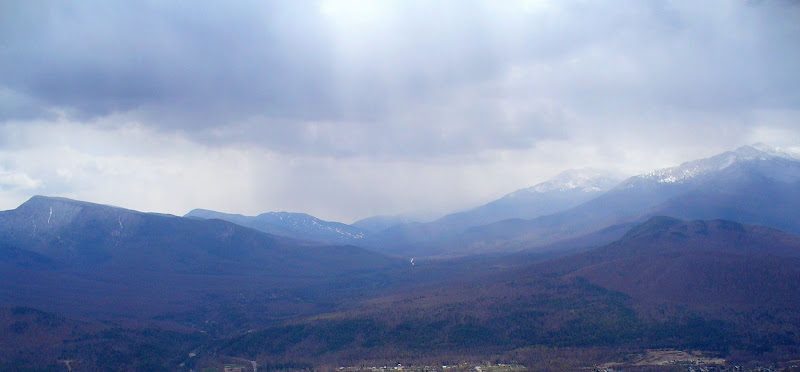
For the second time, it appeared that rain was going to cause a cancellation of a planned hike with some friends from Exeter, NH. We were planning to do a local hike near Twin Mountain, but as we approached that area, the sky looked very threatening. But, as we looked northward, the situation looked better. So, continued in that direction and had a wonderful breakfast at the fabulous Water Wheel Restaurant on Route 2, not far from Bowman, NH.

After our breakfast, the weather conditions still seemed OK where we were. So, we opted to abandon our original plans and instead just stay up north. From the outset, our goal for this day was to do a relatively short and mellow hike. Any epic conquests of one of the high peaks would be left for another time. After some discussion, we decided to head for Gorham and hike to Mascot Pond. It would be a new adventure for our friends from Exeter, and a hike that my wife and I were most willing to repeat

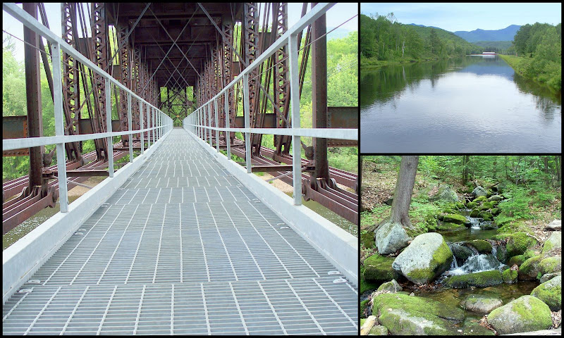
Mascot Pond is reached by hiking the Mahoosuc Trail for a short distance where there is a spur trail that leads to the pond. Rather than drive to the trailhead on Hogan Road, we decided to approach the Mahoosuc Trail from Route 16. This involves parking adjacent to the old B&M railroad bridge and then walking over the Androscoggin River on the trestle which has recently been re-decked with some sturdy metal grate.

Once on the other side of the Androscoggin, there are signs directing you to the “AMC Trail”. But beware! The signage is either a work still in progress (the signs look new), or there is a sign missing for the right turn onto Hogan Road. It’s sort of an intuitive place to turn, and so we didn’t miss the turnoff, but it’s something to keep in mind.

En route to Mascot Pond, there is some neat stuff to see, such as the scenes shown below (the trestle at the beginning of the trek; the crossing over the canal; and a picturesque brook with moss-covered rocks).
MascotEnRoute.jpg

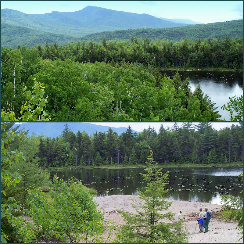
Mascot Pond itself is a scenic spot. Portions of the Carter Range are particularly prominent in the background.
MascotPond1.jpg

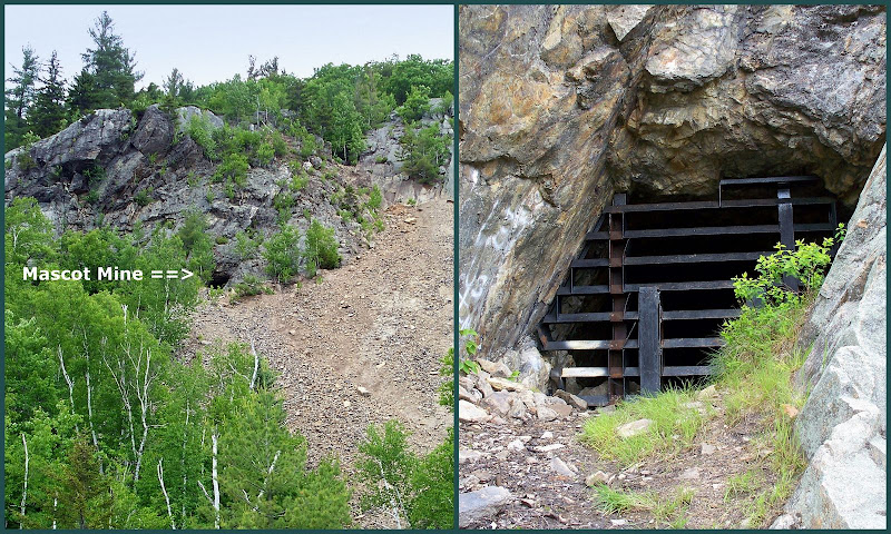
Looming above Mascot Pond is Leadmine Ledge. Apparently, the Mascot lead mine was in operation only for a few years during the late 1800’s. But today, it is perhaps more famous for its bats than for its history as a mine.

One of the hikers in our group (HikerJoanne) did some post-hike research. She discovered that most bats spend their winter at locations in Vermont or New York State. However, the old Mascot mine is one of the few places in New Hampshire where bats hibernate. The mine provides a nearly steady temperature in the 50’s, and it’s estimated that approximately 1,700 bats congregate to “snooze” here for the winter. The experts who study the Mascot bat population have identified 5 separate species. And fortunately, the researchers have found no evidence of “white-nose syndrome” which is a disease that has been devastating hibernating bats in New York State and Massachusetts.

Entrances to the old Mascot mine are blocked with barriers. However, you can hike up a crumbly talus field above Mascot Pond to peer inside the mine. The photo below shows an opening to the mine as it appears from Mascot Pond, and also shows a close-up of the barricaded mine entrance.
MascotMine.jpg

By altering our original plans we were able to stay dry for 99% of our Mascot Pond adventure. It began to drizzle as we approached the car, and the rain steadily increased the further south we went on our way back home. We think we made the right decision to stay up north, and we know for certain that we had a great hike!

1HappyHiker
 
Last edited:
Great photos! You seem to have the knack for finding interesting trips even when your main plans have to be changed due to the weather.
 
The signage was put up by the hydro dam developer to keep you away from the powerhouse. Once you are over the hydro canal they really dont care where you go. There were some very small blue Mahoosuc trail detour signs screwed into trees at the key turns including where you take the right turn immediately after the second bridge and at the powerline, but the brush must be covering them up. Due to some issues with ownership, AMC had to officially abandon the trail in this area. I did note that a new sign board was installed at the parking area at the trestle, so maybe some better directions are forthcoming. (Now if they could only move those cross braces!)

Mascot Pond is on mostly state owned land and its hard to beat the remote feeling for so little effort. Great place to take kids on a first overnight. The local boy scouts used to camp there on occasion and I have never encoutered any one else camping there despite the nice campsites. The only warning is that it is recomended that drinking water be taken from the stream that you follow just before the turn off. About the only use the area gets is rockhounds will pick their way through the tailings piles looking for semiprecious stones. I dont know my rocks very well but Galena is one of the things they find.

There is actually a extended loop you can take where you go up the Mahoosuc trail past the cutoff to the pond, up to where a recent dirt road crosses the trail. Then take a right on the road, walk about 150 feet and look for an obvious herd path that goes steeply up a slope. When you get on top, you are sitting on the ledges above the mine with great views. Now work your way down keeping to the right and you will end up near the caged over openings. Follow the talus field down to the pond and take a left onto the abandoned road that used to access the mine complex. Follow the road down and eventually it hits an obvious "T" intersection with a newer road, take a left at the T and in about a 100 yards you will come out on Hogan road. Take a right and it brings you back up by the dam and eventually back to the trailhead. For history buffs, the old road from the mine may have been part of the original AT route at one point.
 
The signage was put up by the hydro dam developer to keep you away from the powerhouse. . . There were some very small blue Mahoosuc trail detour signs screwed into trees at the key turns . . . I did note that a new sign board was installed at the parking area at the trestle, so maybe some better directions are forthcoming.

There is actually a extended loop you can take where you go up the Mahoosuc trail past the cutoff to the pond, up to where a recent dirt road crosses the trail. Then take a right on the road, walk about 150 feet and look for an obvious herd path . . .
Thanks Peakbagger for the info about the signage. In addition to the large “AMC Trail” signs, at various points along the way, we did see a few of the blue (and very tiny) “Mahoosuc trail detour” signs screwed into trees.

We also noticed that blank sign-board/kiosk that appears to have been recently installed at the trestle parking area. Perhaps some helpful information will soon be posted there, and as you say, maybe some better directions are forthcoming!!

Although I didn’t include it in my Trip Report, we did do a portion of the extended loop that you described. Beyond the spur trail to Mascot Pond, we continued up the Mahoosuc Trail to the dirt road that you mention and made the right turn and hiked the few hundred feet to the obvious herd path that leads to the top of Leadmine Ledge. That was as far as we went since deteriorating weather obscured any worthwhile views. However, it’s fantastic to have your description of how the hike can be extended over Leadmine Ledge to make it a loop hike. Thanks . . . much appreciated!:)
/////////////////////////////////////////////
P.S. I just happened to recall that I also had some stormy weather in early May 2008 when hiking to Leadmine Ledge via the herd path (see photo below)!
Mt.Hayes%20Vu.JPG
 
Last edited:
I was in the mine before the gates were put up (not during hibernation season) and even saw a bat. Later, I was one of the volunteers that installed the gates - there are at least 2 entrances other than the one shown.
 
I was in the mine before the gates were put up (not during hibernation season) and even saw a bat. Later, I was one of the volunteers that installed the gates - there are at least 2 entrances other than the one shown.
Thanks Roy for the additional info and insight about the old Mascot Mine. It’s interesting to learn that there was a time within recent history when the entrances were without barricades.
For history buffs, the old road from the mine may have been part of the original AT route at one point.
Peakbagger, you have “piqued” my curiosity about the former route(s) of the Appalachian Trail (AT) in the Gorham area. I had thought that the Peabody Brook Trail had always been the route of the AT (between Rattle River Trail & Mahoosuc Trail) prior to the re-route onto the Centennial Trail in 1976.

However, my friend (HikerJoanne) informs me that on page 515 of the 1940 edition of the WMG it states that the Appalachian Trail “follows the Carter-Moriah Trail to Gorham. Then the Mahoosuc Trail carries it over the principal summits of the Mahoosuc Range . . .” But, on the other hand, she also has a copy of the 1955 edition of the WMG which indicates that the AT follows the Peabody Brook Trail (between the Rattle River Trail and the Mahoosuc Trail).

So, it would appear that somewhere between 1940 and 1955, the AT was moved east of Gorham to follow the Peabody Brook Trail, which it continued to follow until 1976 when the AT was moved a bit westward to utilize the newly constructed Centennial Trail.

I guess this is a very long way of asking if you have any additional info about the route of the AT in the Gorham area?
 
Neat!

We did the short side trip when we went to Mount Hayes. I could see the mine above the talus field. I don't think it was blocked at that time. I had no idea about the bats. That is some cool info!

I thought then the pond would be a cool place to camp. I'm pretty sure we've been on the knob above the mine Peakbagger speaks of. We gave up on a trip to Hayes in deep snow and just went there. It has a great view of Gorham, the Carters and Northern Presis.

Another way to get across the river would be to park at the snowmobile parking area on Rte. 2 near Jimtown Rd. and follow the snowmobile trail across the top of the same trestle. Much easier for dogs than steel grates!

KDT
 
Last edited:
The 1936 Maine mountain guide shows the AT route going down the Carter Moriah Trail then through town (its not very specific on the actual route, but I would expect it goes over the swinging bridge).

Then the description reads" the main trail starts from a cart road on the N side of Androscoggin river nearly opposite the Mt Madison House. One may be ferried across the river from Gorham Village (inquire at Willis House for location of the ferry man). The cart road runs substantially paralllel to the river a few rods from the bank and the trail starts a littlle down stream (e) from the landing place. The trail follows another cart path diverging uphill with gradual ascent about 1/2 mile. It then leaves the road swings abruptly to the R and ascends through a small growth . In 1/4 mile a branch path leads R about 1/4 mile to Point Lookout, a fine view point". At 1-1/4 miles it appeared to join the current Mahoosuc trail. This description carries forward in the 1940 guide, I cant really trace it after 1940 as my next guide is 1960:(

Unfortunately the map in the guide requires a magnifying lens to see the details of the trail in the Gorham area. So finding the old AT from where it turns off the Mascot pond cart path up to the junction with the Mahoosuc trail is going to be a challenge but there are clues. The lower section of the the path got wiped out when the natural gas line was run through the area. The most recent USGS Topo shows the path intersecting the Hogan road well east of where it appears to intersect the road in the field. Probably the best hope is to go to Point Lookout (no official trail but the folks at the "AMC secret cabin for those in the know" may have run a trail to it as it is in their "backyard") and see if the spur path back to the old AT could be found and hopefully follow it to the intersection with the old AT. Looking at the contours in the area, its pretty obvious where the spur path would run. Then try to follow the old AT route down the steep contour back to the mascot cart path. The area has been cut over a couple of times, but there is a chance that the trail route through the steep area could be followed as the steepness may have discouraged logging and the trail bed would tend to be eroded going up hill.

I look forward to your inevitable subsequent trip report. ;)
 
However, my friend (HikerJoanne) informs me that on page 515 of the 1940 edition of the WMG it states that the Appalachian Trail “follows the Carter-Moriah Trail to Gorham.
Yup, there is an old metal blaze if you look in the right place

So, it would appear that somewhere between 1940 and 1955, the AT was moved east of Gorham to follow the Peabody Brook Trail, which it continued to follow until 1976 when the AT was moved a bit westward to utilize the newly constructed Centennial Trail.
The 1948 guide still has it going by Mascot Mine, perhaps the 1955 book says when it was moved

We did the short side trip when we went to Mount Hayes. I could see the mine above the talus field. I don't think it was blocked at that time.
The gate at the lower entrance is far enough inside that it's not very visible, although not far enough in to get you in the cool on a hot day :-(
 
Great report, John! I haven't been there since I was a kid - I think I remember hopping across the train trestle (no metal supports) and searching for iron crystals in the talus field. Looks like a very picturesque place with some interesting history! :)
 
Yikes! I’m behind in looking at my own thread!:eek: I see that I’ve had multiple replies that I’ve not commented upon! So, here goes.
/////////////////////////////////////////////////
Great photos! You seem to have the knack for finding interesting trips even when your main plans have to be changed due to the weather.
Thanks Bob! There’s an expression out there that goes something like:
“Life is not about waiting for the storm to pass, it is about learning to dance in the rain."
I had no idea about the bats. That is some cool info!

Another way to get across the river would be to park at the snowmobile parking area on Rte. 2 near Jimtown Rd. and follow the snowmobile trail across the top of the same trestle. Much easier for dogs than steel grates!
It was my friend HikerJoanne who came up with the info about the bats. And, I agree with you, i.e. it’s “some cool info”.

Also, speaking of “cool info”, your suggestion about taking the snowmobile trail across the top of the same trestle is some great info for folks hiking with dogs.
The 1936 Maine mountain guide shows the AT route going down the Carter Moriah Trail then through town . . . I look forward to your inevitable subsequent trip report.;)
Peakbagger, I only quoted a small portion of your reply, but I thank you for ALL the additional info you posted regarding the former route of the AT through the Gorham area.

And regarding my “inevitable subsequent trip report” . . . hmmm . . . yeah, you’re probably right . . . there might be one.;)
The 1948 guide still has it going by Mascot Mine, perhaps the 1955 book says when it was moved.
Roy, I also thank you as well for the interesting info you’re posted about the former route of the AT, plus the other interesting tidbits you provided about this area.
Hmmm, that bridge looks pretty interesting . . .
Brian, it is interesting, but not as “interesting” as it was before the spiffy new metal decking was installed. When I crossed the trestle in early May 2008, there was wooden decking with some planks missing here and there!!:eek:
Looks like a very picturesque place with some interesting history!
Thanks for your reply Chris. And, you’re correct on both counts, i.e. “picturesque” and “interesting history”!
 
Last edited:
1948 route

The 1948 guide says for the Carter-Moriah Trail leaving Gorham, you should follow the AT markers. Through town it follows US-2 for 1 3/4 miles, nothing said about how it gets there.

The 1948 guide has the AT following the whole length of the Mahoosuc Trail, crossing under the RR bridge and through the powerhouse and passing Mascot Pond, nothing about Point Lookout. For some reason I had thought that was it's long-term-route, but apparently up till 1940 it followed a cutoff and after 1955 it went up Peabody Brook so that was the official route for 15 years at most. Somebody with the intervening guidebooks could narrow the range.
 
Top