Where Are Good Spots for Close-up Views of The Captain?

vftt.org

Help Support vftt.org:

This site may earn a commission from merchant affiliate links, including eBay, Amazon, and others.

1HappyHiker

Well-known member
Joined
Jan 18, 2007
Messages
1,973
Reaction score
405
Location
Bethlehem, NH
Where are some places to get good up-close views of The Captain? I know there are some locations, such as Mt. Tremont, where you can get a distant view of this feature. However, I’m interested in locations where the view is more close-up (even it involves bushwhacking).

It would seem that there could be a fairly close-up view from South Hancock. However, I don’t seem to have a view of The Captain among my collection of photos from South Hancock. So, if there is a good close-up view of The Captain from there, may I ask that someone post their photo?

There is one place that I’ve found to get a fairly decent, somewhat up-close view of The Captain. This spot is at the end of the forest road that goes off in a NNW direction from the trailhead parking lot at the end of Sawyer River Road. Below is a photo taken this past weekend from the end of the forest road.
TheCaptain_2.jpg

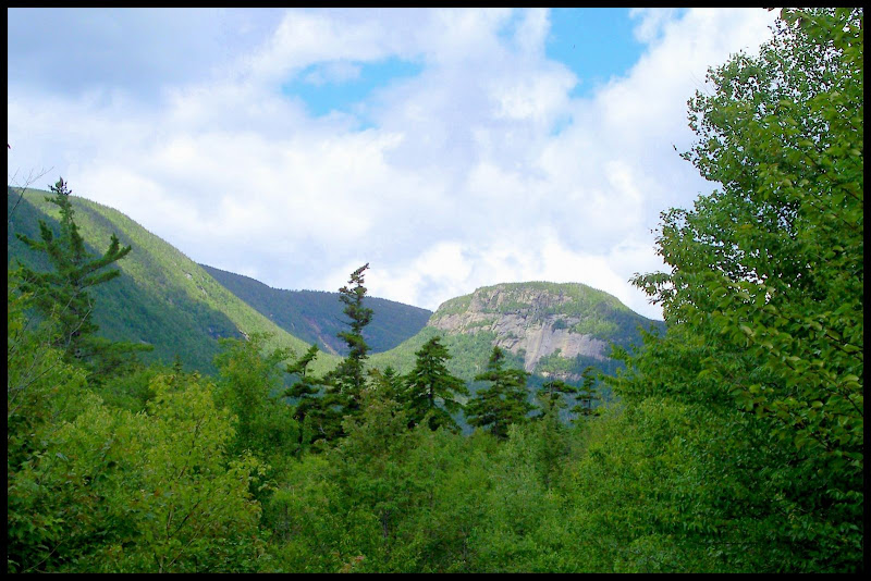
Someday, I might bushwhack to The Captain. But for now, I’m quite content to just look at it, and photograph it!;)
 
That is an excellent view of the Captain you have there! I bet those open areas in your photo on the slope opposite the Cap'n would have a great close-up view!!! Sounds like a good bushwhack someday! :D
 
I have a photo taken from a clearing on the road that goes up the valley that shows less foreground, no good way to scan it but you can take a better one anyway :)

I'll let someone with mapping software confirm this, but I don't think you can see The Captain from S Hancock as E Hancock (on original 1930s 4k list) is in the way

And if you do climb The Captain, all you'll see is scrub :) - you need a more distant view for the cliffs
 
That is an excellent view of the Captain you have there! I bet those open areas in your photo on the slope opposite the Cap'n would have a great close-up view!!! Sounds like a good bushwhack someday! :D
Thanks Chris . . . I think you’re absolutely right . . . sounds like a good bushwhack!
How about from an airplane? :p
Attention: This is the captain speaking. On the right side of the aircraft is a view of The Captain . . . uh, not me . . . the other captain.
I'll let someone with mapping software confirm this, but I don't think you can see The Captain from S Hancock as E Hancock (on original 1930s 4k list) is in the way.
Roy, I think you’re right about this. After posting my question, I played around some more with GoogleEarth, and it does appear to me that a view of The Captain from South Hancock would be blocked by that East Hancock ridgeline.
 
Could be a nicebushwhack.
This is a place routinely visited by climbers, and there is probably a faint path from the end of the road.
More info can be gleaned fortne NE Climbs forum. Do a search on the Captain. I'd put the link here, but embarrassed to say don't know how to do it:(
Sandy
 
There are some good views of it through the trees as you approach it on that fire road. The best time would be late autumn when there are fewer leaves on the trees. I can't recall if there are views, but climbers sometimes make use of a slide on the right side of the valley as you get close to the cliffs - it is just open enough to provide some views.

Photo: http://outdoors.webshots.com/photo/2003448400074054169hLLMRH
Taken from SpongeBob's Webshots account without permission. :eek:

On a related note, anyone know why it is called The Captain? (Hint: think Yosemite)
 
When we did it years ago (during the time that the Sawyer river road was closed due to a washout for a few years), we followed a herd path from the end of the logging road which eventually merged in with the brook draining the area south of the cliffs. We took an alternate path slabbing the east of the bowl (nasty bushwhack) going in, but when we came down, we went down the slope close to the east side of the main cliff and very quickly ended up in the stream bed which we followed down until we hit a flagged herd path that split from the stream and ended up at the end of the logging road. In dry weather, walking down the stream was easy walking compared to the dense growth on either side. It could have grown up over the years and it may be easy walking now, but no guarantees;)
 
Hey, John, did we meet you in the parking lot at the end of Sawyer River Road around 9:30 on Monday morning? We hiked the Mount Tremont loop, where we found fantastic views of Green's Cliff from the overlook at Owl's Cliff. But, the views of The Captain were not as good as in your photo.
 
Good views of cliffs of CAptain doubtful

Do a search of TR's forum for "Captain". Amongst reports, you'll come across 3 TR's by NH-Mt-Hiker pertaining to Captain with links to his webshots albums. Check out his Webshots albums and as Roy said you'll see views up to cliffs through mixed hardwoods and spruce. I find and you probably have found too that pictures of cliffs through trees don't come out worth beans, but I'll bet they still looked pretty cool in person. The pics I looked on NH-MT-Hiker's album appear to have been taken in "early spring???" so leaves were pretty sparse. Best to visit when leaves are down.

Cheers!
 
To: (Trainwreck + Albee + Peakbagger + Jazzbo)
Thanks guys for the advice and links. Great information, and I appreciate you taking the time to post a reply.

To: (Dr. Dasypodidae)
You asked if we met in the parking lot at the end of Sawyer River Road around 9:30 on Monday morning. Nope! Wasn’t me. I did my “photo shoot” on Sawyer River Road on Sunday afternoon. But, it would be nice to meet you sometime!
 
If I remember correctly, it is called the Captain because he stands guard at the entrance to the valley.

Keith

I was thinking something simpler. The Captain is a destination for rock climbers just as El Capitan in Yosemite is a destination for rock climbers. The names are too similar not to be related, and they are both steep granite faces. Does anyone agree with me?
 
I was thinking something simpler. The Captain is a destination for rock climbers just as El Capitan in Yosemite is a destination for rock climbers. The names are too similar not to be related, and they are both steep granite faces. Does anyone agree with me?

This is correct. It's unofficial name is the Captain because of its resemblance to El Capitan.
 
I believe the Captain used to be called Carrigan Pond Peak, unofficially of course. I don't believe this mountain has ever been officially named on a quad map. I'd love to see a map with it named.
 
In looking through the first edition of “Forest and Crag” by Laura and Guy Waterman, I completely overlooked a short passage on page 188 where it indicates that The Captain was given its name by the Portland White Mountain Club in the mid 1870s.
My thanks to Steve Smith for pointing out this passage to me!
100_2530.JPG
 
Thanks for sharing that. I think it is fantastic that "Parker's Mistake" is immediately adjacent to "Camp Organization."
 
Top