Thank you to everyone!
Wow, what a great amount of replies and research to this photo journey! Thanks, everyone! I think Evilhanz has it nailed down - everything seems to point to this being a "working title", if you will, for the abandoned eastern end of the Kenduskeag trail. Still some good questions, though, as to why it was abandoned (though many other good trails were as well for no reason we can determine today), and why one of the photos from Howe peak is labeled as being on the eastern "Kenduskeag Trail", dated one month before the MS trail completion photo... Why would they "finish" on Shelburne-Moriah in October if there was the Kenduskeag trail over Howe in September?
I love the photos, especially the 'trolley'. Who needs bridges? I say bring on the 'trolley'!!
Great idea, Carole! Let's pitch that one to the Wilderness Bridge removal crew - have them leave a cable or two!
One possible explanation is one which I think we both sort of came up with on our own. Perhaps this trail was being developed prior to the 1938 hurricane and had never been officially opened before the hurricane came through and destroyed it.
That hurricane cause quite a stir with all the hiking trails in the area. I originally thought this was the case as well - though evilhanz says that trail maintenance was ended on the eastern end in 1954-1955. Now I'm not so sure. Likely it was abandoned for similar reasons as half the other old trails were.
I'm sure this is the construction of the Kenduskeag Trail. In 1931, there were no trails connecting the lesser Moriah peaks and the only trail constructed before 1934 connecting Hastings with Shelburne Moriah was the Kenduskeag Trail. The fact that it was referred to as the Moriah Skyline Trail early on is not a surprise since that was a common way to refer to any trail or path that follows a ridge or connects highpoints. Porcupine Peak, Cowpasture Peak, and Unknown Peak are the small bumps along this route that you can see from vantage points such as Moriah that were important milestones for the workers while blazing the trail, but not important enough for maps.
Great points, evilhanz! I think you nailed it! Thank you for all the information and dates - that really narrows the timeline down!
")
There are cairns going up Howe (Mtn) Peak from the Kenduskeag but as I did it in winter I don't know about the footway....I have hiked all the "peaks" on this ridge separately but never tried to connect them - that might be an interesting trip with photos in hand.
I've got some printouts of these in my pack - I am definitely going to try and find "Porcupine Peak" somewhere out there on one of those north-facing bumps! The NH/Maine marker would be a fun find, but that location might be a bit vague, and I'm unsure as to how well the stone was actually marked - looks like the photo was written on in this one.
We know a few facts:
-trail ran from the Wild River at Hastings, Maine
to Shelburne Moriah.
-trail crossed "cow pasture peak", a small, mostly-wooded bump on the southeast slopes of Shelburne Moriah, in an area "cut by canyons"
-trail crossed at least two other Unknown Peaks (probably small ones)
-camp for trail workers was in "Moriah Gap".
Cow Pasture Peak looks like a match for one of the bumps on Shelburne Moriah on the way down to Howe along the Kenduskeag. I'd love to know where "Moriah Gap" is.
"154" is "Kenduskeag" (only the western half survives today), and "156" is "shelburne" (same as today). If building a trail from Hastings to Shelburne peak, the obvious routes are either along the ridge over howe peak, or south of that ridge until reaching the shelburne trail. I'd be surprised if a third route was planned, and even more surprised if such a trail was made in 1931 but disappeared before 1941.
Are we sure the captions were added soon after the photos were taken? Maybe by the time of the captioning, the name "skyline" had fallen into disuse. The captioner might clearly remember working on the "skyline" trail, but also know that Howe was on the "kenduskeag".
The eastern half of the 1941 Kenduskeag trail sure looks like a "skyline" trail to me...
Excellent detective work! And indeed, I have no idea when the captioning was written - it could have been years afterward, and in fact the Kenduskeag photo may have been mislabeled for the very reasons you mentioned! Photos were definitely not instant, and working long on the trail wouldn't give someone time to be captioning photos, especially in October. Great point!
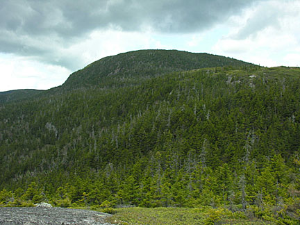
Took this picture 5/27/08 from an unnamed bump east of Shelburne Moriah on the Kenduskeag Trail, just west of the junction with the Shelburne Trail. This was maybe taken from a more southerly angle than my shot. It is the first bump you come to where you can get up above the trees and look around.
I would also venture a guess that Moriah Gap is between Howe Peak and these bumps on the Shelburne Trail. Very notch-like before turning west on Kenduskeag.
I agree that the trolley must have crossed the river near The Roost. I think you can still find evidence of it there.
Great photo! Looks like almost the same location - another place I will have to bushwhack to and check out!
The old maps show the Kenduskeag hitting close to where the road splits - I'll have to crawl around there sometime and look for old cables!
I posted scans of the 1936 AMC White Mountain Guide Jackson-Carter Sheet as well as the description of the Kenduskeag Trail. There is no mention of it in my 1931 Guide.
That is a great map - thanks for the post!!
I think the 1937, 1942 USGS SE corner shows old route Kanduskeag going over Howe Pk, then over the 2500' bump, then along 2000' finger of ridge where it slabbed down ridge towards Roost spot that Vegematic mentions. I bet it was routed to follow some old skidder road along the 2000' finger of the ridge from Roost. The place was heavily logged afterall and skidder road is probably still discernable. That's probably why it was considered such a skyline trail.
Jazzbo, I think I know what road you mean! If it is the one I think it is, it still shows up in Google Earth and is one of the landmarks I have on my list to check out. One end is only a quarter mile from the High Water trail.
It passed very close to the summit of Howe, but not directly over it according to the '36 (and later) AMC guides. The '34 guide doesn't specifically mention Howe, so it seems to be a clarification. Also, maintenance ended on the eastern part of the trail around 1954-1955.
Thanks again for the dates and AMC info, evilhanz!
Thanks to everyone for the maps, scans, and information!