
Jazzbo
Well-known member
- Joined
- Jan 1, 2005
- Messages
- 1,197
- Reaction score
- 163
Jay peak, Big Jay, VT via Long Trail and Bushwhack
This was an AMC trip lead by Joe Comuzzi and Tim Roaix. We had a party of 6 which besides leaders included Sidharth S, Bob A, Vince P, and myself. In researching this hike to the Jays, I searched VFTT and could only find one TR by King Tut, so I thought it would be beneficial to write up a TR about our trip to the Jays.
It’s a long haul up to Jays by the Canadian Border. Mileage from Nashua NH to Jay VT is 193 miles one way. I was thankful to be doing this with a group that enabled carpooling. I met up with Bob A and Siddharth S at LL Bean at Exit 6 in Nashua. We arrived at Joe’s cottage in Campton at around 9:00. We sat and chatted for short time and went to bed because we had to get up pretty early since we had a 2.5 hour drive just to get to TH at Jay. We woke at 4:45 and were on road before 6:00.
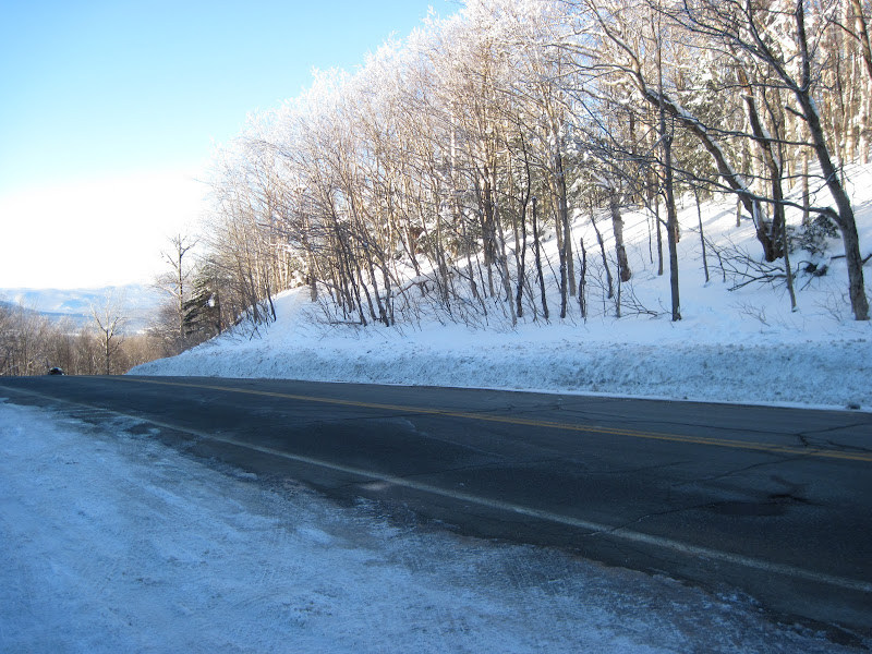
It was right around 0 F when we left Campton. It was interesting to note how the temperature dropped a good 10 deg F above Franconia Notch. The drive up to Jays is beautiful. It’s a part of NH I haven’t seen yet. That’s the great thing about peak bagging. It gives you a reason to go see other parts of our beautiful New England. The ice formations in the road cuts were nice and icy blue.
We crossed the CT River and VT border and joined up with Route 91. The sunny day and country side were gorgeous in early morning sun. We got off at Exit 26 and traveled north along Route 5. I won’t go into detail about exact route, but we did go through Troy VT and then Jay VT. We followed Route 242 and ascended Jay Pass at approx. 2200’ elevation. The Long Trail crosses here and there's well plowed area for parking.
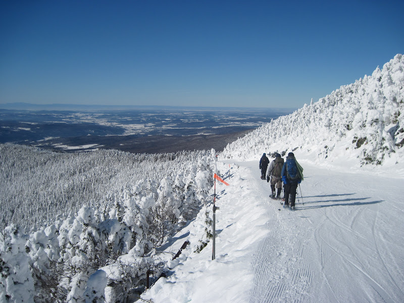
We were on the Long Trail heading northbound by 9:30 or so. We didn’t now what to expect. It turned out that although we didn't see any other snowshoers this day, the Long Trail was well packed out. We made a wrong turn early on and wound up at a hut.
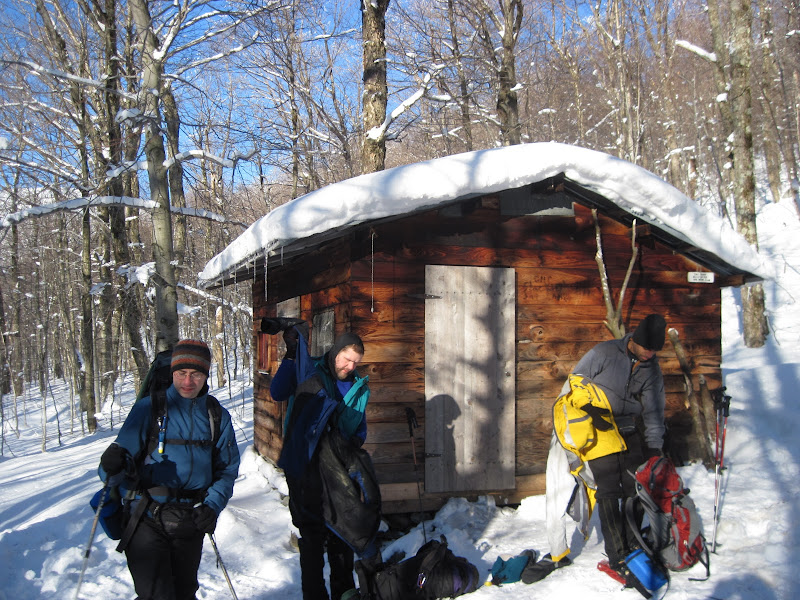
It was neat to see the hut and we worked our way back to the Long Trail. We reached a junction near a bump on the ridge which passed close by a ski trail where we got preview of the long distance views ahead. We lost the Long Trail for a short time, but got back on trail fairly quickly. The spruce was heavily cloaked in snow from snow falls of past week. Nevertheless the trails well blazed and blazes were easy to find even with the heavy snow cover.
We came to a point where the Long Trail intersects with ski trails coming down from the summit buildings. We traveled the rest of the way on ski trails until we came to summit buildings. We stopped a the summit where we were treated to incredibly long range views in all directions – not a cloud in the ski anywhere. We could see Adirondacks to west and Presidential range to the southeast.
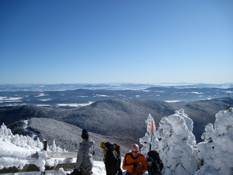
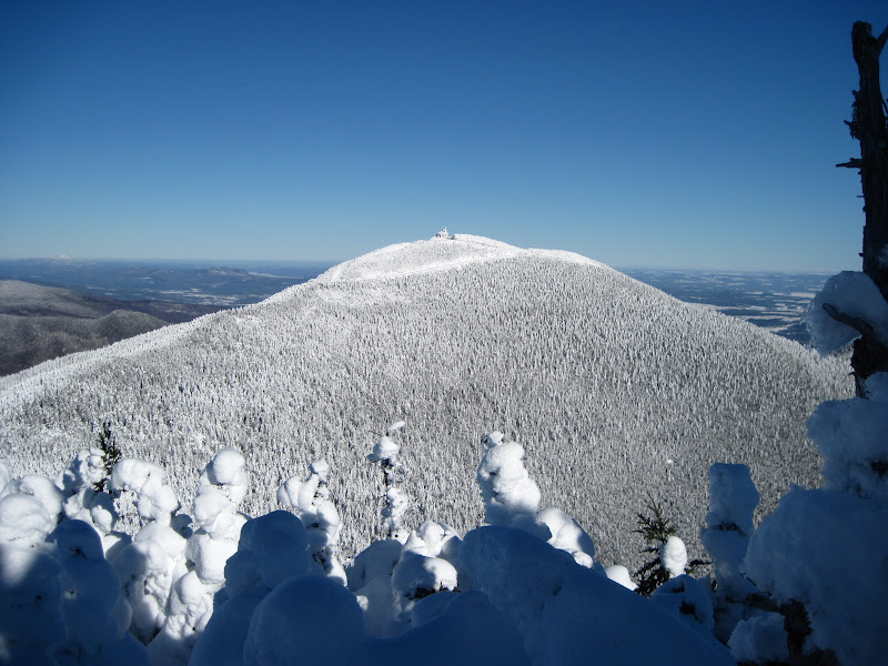
Big Jay and Mansfield in the distance to the south.
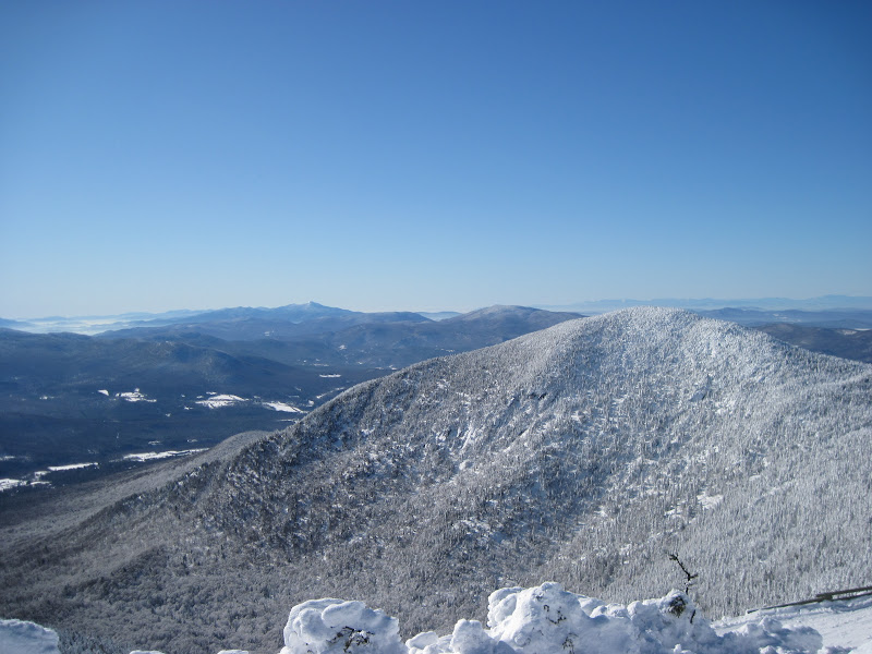
We warmed up and ate lunch inside the Tramway building. There is no food for sale and the soda machine was out of order. The bathrooms have water, but ski patrol didn’t recommend drinking it. We got back on the ski trail and headed for the saddle ridge connecting with Big Jay to the south. This picture is looking west towards valley of Lake Champlain with Adirondacks to far west.
We came to some snow fences with opening that connects to the connecting ridge. There were rope barriers and signs warning of dire consequences for trespassing. Ski patrollers said this was mainly addressed to skiers tempted to use the bootleg trails going down from Big Jay. We were pleasantly surprised to find trail on connecting ridge much better packed out than the Long Trail was going up. Reason proved to be fact that skiers were using this route to get to the bootleg trail down from Big Jay of which we encountered two separate parties heading out to Big Jay to ski the bootleg trails.
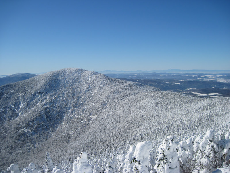
Views of Jay Peak from Big Jay.
We had contemplated bushwhacking down from Big Jay, but decided to return back the way we came. The bowl in between the two peaks looks like it would make for a nice bushwhack descent. Maybe next time…..
If you’re doing the Jays, I suggest doing it when you have good clear weather. You’ll be glad you did because the views are really fine.
Thanks to Joe and Tim for organizing this excellent trip and for arranging for such amazing weather. BTW this was #85, #86 for me on my NEHH list. It was #99 for Tim Roaix on his winter NEHH list. Tim still has to do Bounday Peak in Maine hopefully this March.
This was an AMC trip lead by Joe Comuzzi and Tim Roaix. We had a party of 6 which besides leaders included Sidharth S, Bob A, Vince P, and myself. In researching this hike to the Jays, I searched VFTT and could only find one TR by King Tut, so I thought it would be beneficial to write up a TR about our trip to the Jays.
It’s a long haul up to Jays by the Canadian Border. Mileage from Nashua NH to Jay VT is 193 miles one way. I was thankful to be doing this with a group that enabled carpooling. I met up with Bob A and Siddharth S at LL Bean at Exit 6 in Nashua. We arrived at Joe’s cottage in Campton at around 9:00. We sat and chatted for short time and went to bed because we had to get up pretty early since we had a 2.5 hour drive just to get to TH at Jay. We woke at 4:45 and were on road before 6:00.
It was right around 0 F when we left Campton. It was interesting to note how the temperature dropped a good 10 deg F above Franconia Notch. The drive up to Jays is beautiful. It’s a part of NH I haven’t seen yet. That’s the great thing about peak bagging. It gives you a reason to go see other parts of our beautiful New England. The ice formations in the road cuts were nice and icy blue.
We crossed the CT River and VT border and joined up with Route 91. The sunny day and country side were gorgeous in early morning sun. We got off at Exit 26 and traveled north along Route 5. I won’t go into detail about exact route, but we did go through Troy VT and then Jay VT. We followed Route 242 and ascended Jay Pass at approx. 2200’ elevation. The Long Trail crosses here and there's well plowed area for parking.
We were on the Long Trail heading northbound by 9:30 or so. We didn’t now what to expect. It turned out that although we didn't see any other snowshoers this day, the Long Trail was well packed out. We made a wrong turn early on and wound up at a hut.
It was neat to see the hut and we worked our way back to the Long Trail. We reached a junction near a bump on the ridge which passed close by a ski trail where we got preview of the long distance views ahead. We lost the Long Trail for a short time, but got back on trail fairly quickly. The spruce was heavily cloaked in snow from snow falls of past week. Nevertheless the trails well blazed and blazes were easy to find even with the heavy snow cover.
We came to a point where the Long Trail intersects with ski trails coming down from the summit buildings. We traveled the rest of the way on ski trails until we came to summit buildings. We stopped a the summit where we were treated to incredibly long range views in all directions – not a cloud in the ski anywhere. We could see Adirondacks to west and Presidential range to the southeast.
Big Jay and Mansfield in the distance to the south.
We warmed up and ate lunch inside the Tramway building. There is no food for sale and the soda machine was out of order. The bathrooms have water, but ski patrol didn’t recommend drinking it. We got back on the ski trail and headed for the saddle ridge connecting with Big Jay to the south. This picture is looking west towards valley of Lake Champlain with Adirondacks to far west.
We came to some snow fences with opening that connects to the connecting ridge. There were rope barriers and signs warning of dire consequences for trespassing. Ski patrollers said this was mainly addressed to skiers tempted to use the bootleg trails going down from Big Jay. We were pleasantly surprised to find trail on connecting ridge much better packed out than the Long Trail was going up. Reason proved to be fact that skiers were using this route to get to the bootleg trail down from Big Jay of which we encountered two separate parties heading out to Big Jay to ski the bootleg trails.
Views of Jay Peak from Big Jay.
We had contemplated bushwhacking down from Big Jay, but decided to return back the way we came. The bowl in between the two peaks looks like it would make for a nice bushwhack descent. Maybe next time…..
If you’re doing the Jays, I suggest doing it when you have good clear weather. You’ll be glad you did because the views are really fine.
Thanks to Joe and Tim for organizing this excellent trip and for arranging for such amazing weather. BTW this was #85, #86 for me on my NEHH list. It was #99 for Tim Roaix on his winter NEHH list. Tim still has to do Bounday Peak in Maine hopefully this March.
Last edited:
")