Quite a Contrast from One Day to the Next (Apr 15-16, 2010)

vftt.org

Help Support vftt.org:

This site may earn a commission from merchant affiliate links, including eBay, Amazon, and others.

1HappyHiker

Well-known member
Joined
Jan 18, 2007
Messages
1,973
Reaction score
405
Location
Bethlehem, NH
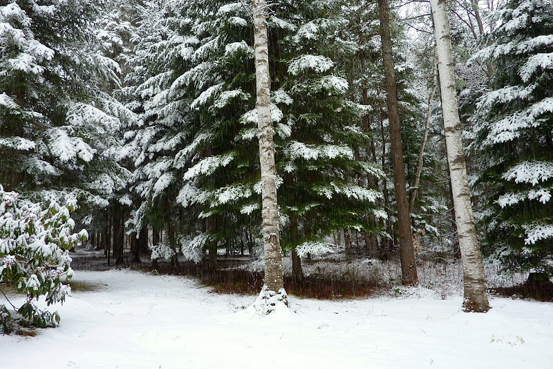
Below is a photo taken out my back door this morning (16-April)!

P1040721.JPG

This is quite a contrast to the conditions experienced only yesterday (15-April). I had just a few hours available to me to hike, and so I did the short trek to that spot called the "Nubble" which is located in the Twin Mountain area. Since I live in Bethlehem, the Nubble is a local hike for me.

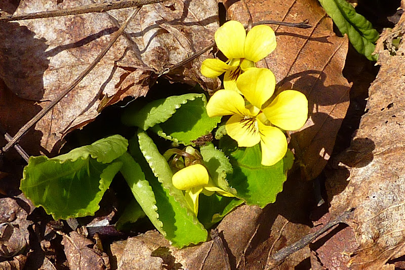
Less than 24 hours ago, there were snow-free conditions all the way to the Nubble, and there were yellow violets in bloom in several spots along the way.

P1040702.JPG

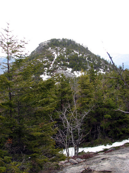
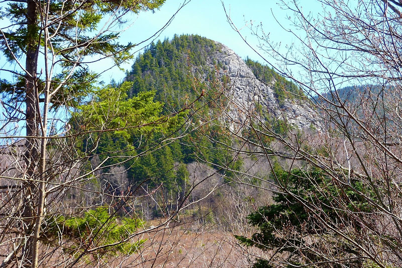
While hiking through the open woods on the approach to the Nubble, you could see it through the trees, rising up from its snow-free surroundings.

P1040707.JPG

Then, once on top of the Nubble, the only snow to be seen was on the higher peaks, such as shown in the photo below with the three Sugarloafs (North, Middle, South) in the foreground and the Presidential Range in the background.

P1040716.JPG

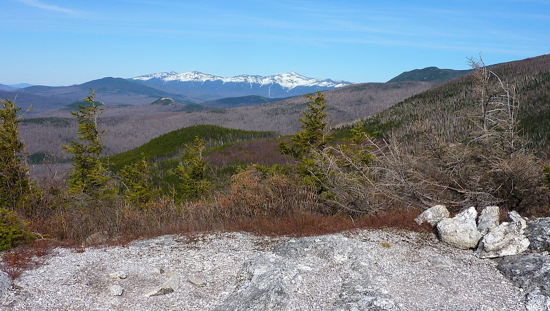
It was a short hike, but enjoyable nonetheless. And, it was a short Springtime experience (before return to winter conditions), but enjoyable nonetheless!:D

1HappyHiker
 
Last edited:
Nice little back yard you have there !
 
John, I hear you. Yesteday we took a nice little hike and I was wearing shorts. This morning...well, it's a different story. Snow has stopped now but it will be interesting to see what it's like higher up. At least someone was happy with this morning's snow.
 
Nice post. Now here's a stupid question from a longtime lurker, infrequent poster. Are the Nubble and Peak Above the Nubble two different entities? Thanks in advance.
 
Bjc; Fisher Cat; Tom & Atticus: Thanks guys for your reply!

Cyohman: Thanks also for your reply. Regarding your question, yes "The Nubble" and the "Peak above the Nubble" are separate entities. I'm not trying to be flippant, but the "Peak above the Nubble" is located above "The Nubble", and thus the name.

The "Peak above the Nubble" has an elevation of 3,813 ft and is on both the NE and the NH 100 Highest list. Whereas, "The Nubble" weighs in at only 2,713 ft of elevation.
Nice post. Now here's a stupid question from a longtime lurker, infrequent poster. Are the Nubble and Peak Above the Nubble two different entities? Thanks in advance.
 
@1HappyHiker

No worries about the response. I said it was a stupid question. :)

I've been interested in the Peak Above The Nubble since I finished the NH 48 (not a fan of lists, but they draw me in). The Nubble now intrigues me as well. It reminds me of the Sugarloaves in Dixfield, Maine. What route did you take there? Do people rock climb on it?

Thanks again.
 
I've been interested in the Peak Above The Nubble since I finished the NH 48 (not a fan of lists, but they draw me in). The Nubble now intrigues me as well. It reminds me of the Sugarloaves in Dixfield, Maine.
What route did you take there? Do people rock climb on it?
Sorry, but I have no info as to whether the Nubble is used by rock climbers.

Regarding the route that I took, it was sort of a combination of a road walk, a bushwhack and a herd path. My route began at the Beaver Brook rest area parking lot on Rt 3, and progressed to the far east-end of Gale River Rd (also the snowmobile Route 11 corridor). At a point slightly west of the Nubble I left the snowmobile trail and began a combination herd path and bushwhack trek to the south end of the Nubble where I began my ascent. Perhaps this sounds a bit complicated and convoluted, but after you've done it a time or two, it's a quick & easy trek. It's even quicker & easier in the summer when the Gale River Rd is open and you can park at a gated area at a cul-de-sac at the eastern end of this road.
 
Yay for winter hanging on! :)

Once again, I love your different and unique pics. Esp the one where you are approaching the Nubble. It kind of reminds me of the trail that is rising up towards Dickey Mtn, heading away from Welch Mtn.

822401561_bmYZK-L.jpg


Thanks for posting!!
 
. . . I love your different and unique pics. Esp the one where you are approaching the Nubble. It kind of reminds me of the trail that is rising up towards Dickey Mtn, heading away from Welch Mtn . . .
Thanks for the kudos, Phil!
Hmmm! Regarding the photo you posted in your response, I can see the similarity that you noted relative to the photo in my report.
My knowledge of geology (among other things!) is sorely lacking. Perhaps both these peaks were the result of similar forces of nature.:confused:
 
I've been wanting to go up to the Nubble, too. You've made the "want" feeling more urgent! We could see the Nubble from our home when we lived in the Pierce Bridge section of Bethlehem.
 
Very nice report and photos, as usual.

. . . I love your different and unique pics. Esp the one where you are approaching the Nubble. It kind of reminds me of the trail that is rising up towards Dickey Mtn, heading away from Welch Mtn . . .
Hmmm! Regarding the photo you posted in your response, I can see the similarity that you noted relative to the photo in my report.
My knowledge of geology (among other things!) is sorely lacking. Perhaps both these peaks were the result of similar forces of nature.:confused:
I do not know the geology of these specific peaks either, but perhaps they shared a plutonic relationship. ;)
 
Thanks John

I have also been drawn to this peak. First kept noticing it coming from the east on Rte 3 and wanted to visit it. But then saw the rock face from the west and started to imagine a sheer climb.

Sounds like a mellow jaunt.
 
Ellen, and Mark: Thanks for your reply!:)

I have also been drawn to this peak. First kept noticing it coming from the east on Rte 3 and wanted to visit it. But then saw the rock face from the west and started to imagine a sheer climb.Sounds like a mellow jaunt.
Andrew: Thanks for your reply, also.
And, you're right . . . it is a mellow jaunt. The final approach from the south end of the Nubble is pretty easy, and the herd path is quite evident at this point. Attempting to scale this peak by some route other than the herd path would be pretty tough going!
 
Top