1HappyHiker
Well-known member
Although I've hiked in other parts of Canada, this was the first time that I've ever set foot in the province of New Brunswick.
Wow! What a really neat place, and the folks we met there were just as down-to-earth as the folks you meet here in the North Country area of New Hampshire.
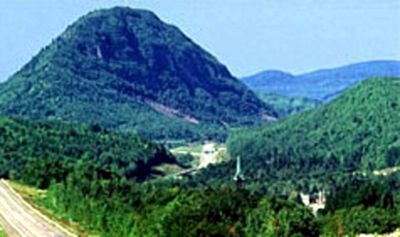
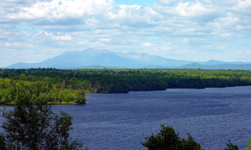
Travelling north on I-95 en route to Canada, we were pleasantly surprised to get such an impressive view of Mt. Katahdin from a roadside pull-off area. Although I've hiked Mt. Katahdin many, many years ago, I'm totally unfamiliar with the other surroundings in that part of Maine. Therefore, I don't know how impressive the view of Katahdin might be from other locations. Regardless, I thought the vista from this roadside spot was pretty nice (see photo below).
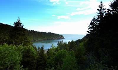
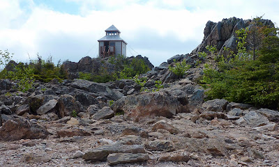
Okay, I'll return now to the Canadian portion of our trip!") One of the stops we made was at the Mt. Carleton Provincial Park. There are hiking trails leading to four mountain peaks within this park. We hiked to Mt. Carleton which has an elevation of only 2,690 feet. However, not only is it the highest peak in the park, but it's also the highest peak in the Canadian Maritime Provinces. Another claim to fame is that Mt. Carleton is one of the peaks along the route of the International Appalachian Trail.
One of the stops we made was at the Mt. Carleton Provincial Park. There are hiking trails leading to four mountain peaks within this park. We hiked to Mt. Carleton which has an elevation of only 2,690 feet. However, not only is it the highest peak in the park, but it's also the highest peak in the Canadian Maritime Provinces. Another claim to fame is that Mt. Carleton is one of the peaks along the route of the International Appalachian Trail.
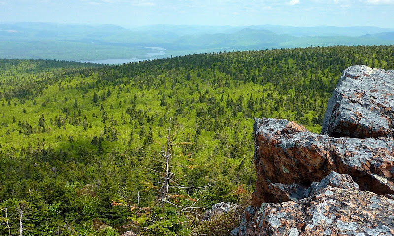
Below is a photo showing one of the views from Mt. Carleton.
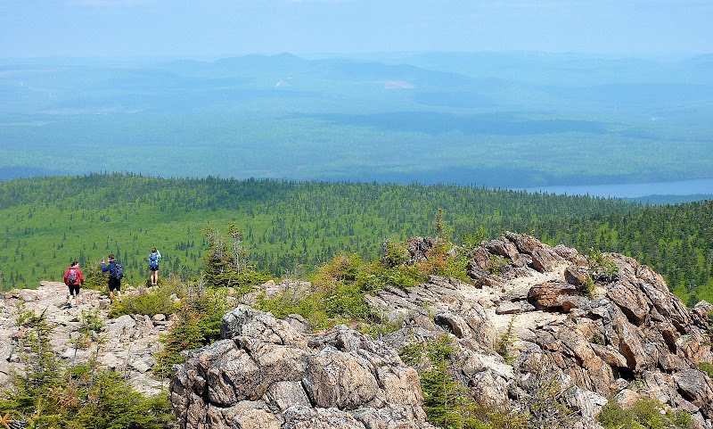
Below is yet one more snapshot which was taken from Mt. Carleton. I met the 3 hikers shown in this photo. I was surprised to discover that they were not Canadian. They were from Maine!
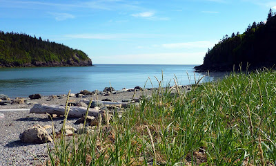
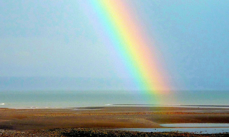
In addition to Mt. Carleton, we visited several other locations within New Brunswick, including the Fundy National Park. We thought that was a pretty spectacular spot! Shortly after arriving, there was a rain shower which resulted in the appearance of a brilliant rainbow over the Bay of Fundy. It didn't last very long, and so I didn't really have much time to futz around with the camera. Below is a rather grainy snapshot, but I think you can get the general idea.
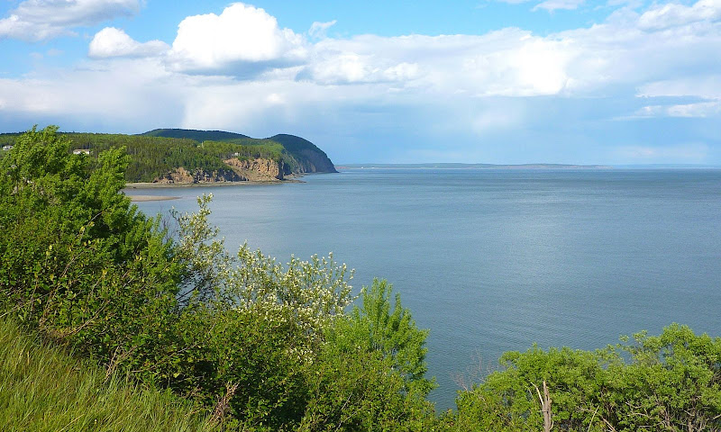
Without dark clouds and rain, there are stunning views of the Bay of Fundy from several locations in the surrounding area. Below is a photo of one such view.
Because of the unique shape of the bay, the tides in the Bay of Fundy are said to be the most extreme in the world. The difference in water level between high tide and low tide can be as much as 48 feet! The time between a high tide and a low tide is about 6 hours.
And so, you can reasonably expect to see at least one high and one low tide during daylight hours.
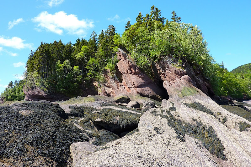
When the tide is out, you can walk all around areas which are several feet under water at high tide. This provides some great opportunities to get some unique views. The photo shown below was taken at low tide. At high tide only the reddish-pink rocks in the center of the snapshot are visible.
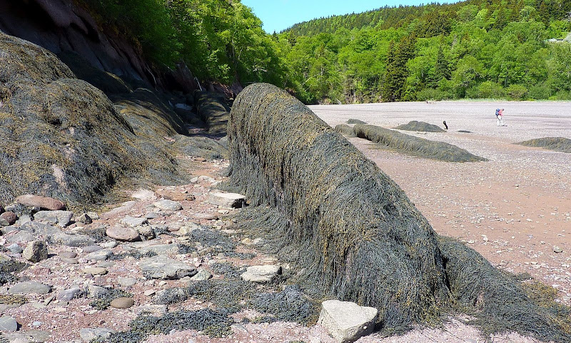
Also at low tide, there are some other interesting things that become visible, such as outcroppings that are covered in sea weed (see photo below). To me, it sort of resembles a wet shaggy dog!
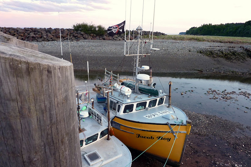
Fishermen must wait for a high tide to "float their boat". Boats become landlocked at low tide (as shown in the photo below).
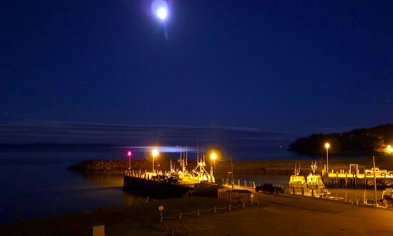
Once the waters begin to raise enough for the boats to float, then the fishermen fire up the engines and they head out to sea. Oftentimes, this involves heading out into the dark of night, as was the case when the photo below was taken. (Fishermen's pick-up trucks are visible on the docks.)
We spent a wonderful few days in Canada's Province of New Brunswick. As we crossed through customs at the US/Canadian border, the Customs Agent asked the routine question regarding the purpose of our visit to Canada. When we responded that it was for vacation, she seemed a bit taken aback. We, in turn, were taken aback when she responded by saying she found that to be usual since not that many people go there for vacation. I simply said "really"! However, I was thinking to myself that I know several folks who go to Canada for vacation. And, on this trip alone, I met 3 people while hiking who were from the State of Maine. Plus, at one of the places where we stayed overnight, the folks next to us were from Connecticut, and they also were there on vacation. Go figure!
1HappyHiker
Wow! What a really neat place, and the folks we met there were just as down-to-earth as the folks you meet here in the North Country area of New Hampshire.
Travelling north on I-95 en route to Canada, we were pleasantly surprised to get such an impressive view of Mt. Katahdin from a roadside pull-off area. Although I've hiked Mt. Katahdin many, many years ago, I'm totally unfamiliar with the other surroundings in that part of Maine. Therefore, I don't know how impressive the view of Katahdin might be from other locations. Regardless, I thought the vista from this roadside spot was pretty nice (see photo below).
Okay, I'll return now to the Canadian portion of our trip!
One of the stops we made was at the Mt. Carleton Provincial Park. There are hiking trails leading to four mountain peaks within this park. We hiked to Mt. Carleton which has an elevation of only 2,690 feet. However, not only is it the highest peak in the park, but it's also the highest peak in the Canadian Maritime Provinces. Another claim to fame is that Mt. Carleton is one of the peaks along the route of the International Appalachian Trail.Below is a photo showing one of the views from Mt. Carleton.
Below is yet one more snapshot which was taken from Mt. Carleton. I met the 3 hikers shown in this photo. I was surprised to discover that they were not Canadian. They were from Maine!
In addition to Mt. Carleton, we visited several other locations within New Brunswick, including the Fundy National Park. We thought that was a pretty spectacular spot! Shortly after arriving, there was a rain shower which resulted in the appearance of a brilliant rainbow over the Bay of Fundy. It didn't last very long, and so I didn't really have much time to futz around with the camera. Below is a rather grainy snapshot, but I think you can get the general idea.
Without dark clouds and rain, there are stunning views of the Bay of Fundy from several locations in the surrounding area. Below is a photo of one such view.
Because of the unique shape of the bay, the tides in the Bay of Fundy are said to be the most extreme in the world. The difference in water level between high tide and low tide can be as much as 48 feet! The time between a high tide and a low tide is about 6 hours.
And so, you can reasonably expect to see at least one high and one low tide during daylight hours.
When the tide is out, you can walk all around areas which are several feet under water at high tide. This provides some great opportunities to get some unique views. The photo shown below was taken at low tide. At high tide only the reddish-pink rocks in the center of the snapshot are visible.
Also at low tide, there are some other interesting things that become visible, such as outcroppings that are covered in sea weed (see photo below). To me, it sort of resembles a wet shaggy dog!
Fishermen must wait for a high tide to "float their boat". Boats become landlocked at low tide (as shown in the photo below).
Once the waters begin to raise enough for the boats to float, then the fishermen fire up the engines and they head out to sea. Oftentimes, this involves heading out into the dark of night, as was the case when the photo below was taken. (Fishermen's pick-up trucks are visible on the docks.)
We spent a wonderful few days in Canada's Province of New Brunswick. As we crossed through customs at the US/Canadian border, the Customs Agent asked the routine question regarding the purpose of our visit to Canada. When we responded that it was for vacation, she seemed a bit taken aback. We, in turn, were taken aback when she responded by saying she found that to be usual since not that many people go there for vacation. I simply said "really"! However, I was thinking to myself that I know several folks who go to Canada for vacation. And, on this trip alone, I met 3 people while hiking who were from the State of Maine. Plus, at one of the places where we stayed overnight, the folks next to us were from Connecticut, and they also were there on vacation. Go figure!
1HappyHiker
Last edited: