My apologies for hi-jacking an Owlshead thread (probalby not the first time that has happened).  Here are the creative replies so far on that thread to my trivia question stimulated by HikerBob's long approach to Garfield for his NH48 finish posted by MichealJ. And, yes, the question is like the "traveling saleman" problem, as noted by Tim (Hikebikeskifish).
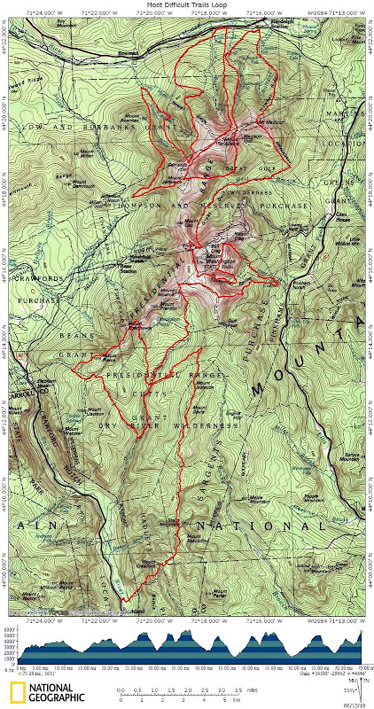
Just to clarify with some ground rules for original trivia question below: 1) using a tunnel to cross a road, such as the I-93 parkway in Franconia Notch, should not count, 2) road walks should not count, 3) Mount Washington's Auto Road should count as a road (but, the Cog tracks are ok), 4) repeating any stretch of trail should not count, 5) crossing any previously hiked trail segment should not count, 6) trails no longer officially maintained OR not shown in the latest edition of the White Mountain Trail Guide should not count, and 7) bushwhacking should not count.
So, it seems that rules 3, 4, and 5 limit the possibility for doing an out and back in the Presi's from the south to roughly just south of the Washington-Clay col, although I am in Seattle and do not have maps of the Whites in front of me at the moment. So, we need some number tallying to compare some of the suggested Pemi meanderings, the southern Presi's, the Wild River Wilderness, and any others.
Then, once we get a consensus on the longest route, we can advertise far and wide for ultra-athletes from all over the world to take the challenge. We also will need a catchy name for the event.
Originally Posted by MichaelJ
HikerBob finished his 48 on Garfield from Lincoln Woods.
Dr. Dasypodidae: Ok, trivia question: What is the longest one-way trail approach to a 4000-footer in the Whites without crossing a road or another 4000-footer? Name the peak, trails, and total one-way mileage.
Dr. Dasypodidae
Yesterday, 07:16 AM #54
Tom Rankin
Depending on how you define 'another 4000-footer', I could come up with an obscenely long hike that skirts several summits. Is this allowed in this game? Also, define 'road'. Do tunnels count? What about 'old' trails?
Anyway, my offering: Start at Profile Lake, hit the hut, take OBP DOWN, Falling waters up, turn south back down Franconia, West on Spring/scenic trail, Flume to Osseo, North to Franconia Brook camps, East on Wilderness, North on Shoal, take the AT, pass Zealand Hut, and go all the way to Mt. Tom or Hale!
Yesterday, 07:34 AM #55
bikehikeskifish
I'm guessing there is a route to Jackson (or Pierce even) involving Davis Path all the way to, around and down the east side of Washington and back around the west side of the Presidentials, down to Dry River, Saco, Webster Cliff and back up. I'm sure we can include some road walks, without actual crossings.
This is the Traveling Salesman Problem which is of course NP-Complete.
Yesterday, 09:18 AM #56
MichaelJ
I was thinking something similar to Tim's idea. No map in front of me, but since Isolation is on a spur, there must be a way to take the Davis Path from 302 all the way up to Boott Spur, then around Monroe, back down into the Dry River Wilderness, then back up, and hit a summit after many miles.
If that doesn't win, then again since Zealand is on a spur, how about in on Wilderness (or Hancock Notch?) through Stillwater to Ethan Pond Trail to the hut, then up Twinway, past Zealand & around Guyot back to South Twin?
One more guess - Wild River Campground, Wild River Trail to Wildcat River Trail to Carter Notch to 19 Mile-Brook Trail down to Carter Dome Trail then back up to Zeta Pass and to the Dome or South, whichever's then further?
Yesterday, 09:29 AM #57
sierra
Owls head is the furthest unless this is some kind of trick question
Yesterday, 09:43 AM #58
bikehikeskifish
There is no trail to Owl's head.
Yesterday, 09:52 AM #59
MichaelJ
Owl's Head has the longest of all the shortest approaches. Dr. D. is soliciting the overall longest approach. Er, does that make sense?
Yesterday, 09:52 AM #60
dug
I'm guessing Mt. Madison from Davis Path
RoySwkr Yesterday #61
Field would be farther via Avalon Tr, or how about up Thoreau Falls, down Shoal, and across Carrigain Notch to Signal Ridge?
I'll bet that it's something like Madison, starting at Mt Pickering and zigzagging Dry River, Great Gulf, and RMC trails.
Bikehikeskifish Yesterday, 09:57 AM #62
Madison via Davis Path is probably a good guess, if you define "one-way" not including U-turns. If you define it as no back-tracking on a trail (crossing a used trail is OK) then I think you can go all the way to and around Madison, and then snake up and down the network of trails on the NW side of Madison->Washington before heading south (and snaking some more) and finally ending up on Pierce or Jackson. Heck you can snake your way up and down the Great Gulf / Madison Gulf as well - as long as you don't cross the Auto Road.
The Auto Road divides the map into two lobes - north and south of Washington - how many trails cross north-south without crossing the summit or the Auto Road - At least two. With more, perhaps it can get even longer.
Yesterday, 10:03 AM #63
Dave Bear
Makes me think of the crazy notion I had one time of doing a Presi Figure Eight involving Davis and Great Gulf. Mine would have to be a backpack but I am sure that there are folks on this forum that could do it in a day!
Yesterday, 10:52 AM #64
DougPaul
Dr D's problem statement does not disallow loops. Thus the distance could be arbitrarily large. Infinite if you wish.
Example: I could start at Lincoln Woods and go around Owls Head as many times as I wish before climbing the slide to the summit. (Had to make it relevant to the OP's topic. And, for the purposes of this comment, let's assume that the standard slide route up Owls Head is a trail.)
Yesterday, 11:25 AM #65
David Metsky
Moderator Note
That might make a good thread on its own. Let's stick to the topic here.
Here are the creative replies so far on that thread to my trivia question stimulated by HikerBob's long approach to Garfield for his NH48 finish posted by MichealJ. And, yes, the question is like the "traveling saleman" problem, as noted by Tim (Hikebikeskifish). Just to clarify with some ground rules for original trivia question below: 1) using a tunnel to cross a road, such as the I-93 parkway in Franconia Notch, should not count, 2) road walks should not count, 3) Mount Washington's Auto Road should count as a road (but, the Cog tracks are ok), 4) repeating any stretch of trail should not count, 5) crossing any previously hiked trail segment should not count, 6) trails no longer officially maintained OR not shown in the latest edition of the White Mountain Trail Guide should not count, and 7) bushwhacking should not count.
So, it seems that rules 3, 4, and 5 limit the possibility for doing an out and back in the Presi's from the south to roughly just south of the Washington-Clay col, although I am in Seattle and do not have maps of the Whites in front of me at the moment. So, we need some number tallying to compare some of the suggested Pemi meanderings, the southern Presi's, the Wild River Wilderness, and any others.
Then, once we get a consensus on the longest route, we can advertise far and wide for ultra-athletes from all over the world to take the challenge. We also will need a catchy name for the event.
Originally Posted by MichaelJ
HikerBob finished his 48 on Garfield from Lincoln Woods.
Dr. Dasypodidae: Ok, trivia question: What is the longest one-way trail approach to a 4000-footer in the Whites without crossing a road or another 4000-footer? Name the peak, trails, and total one-way mileage.
Dr. Dasypodidae
Yesterday, 07:16 AM #54
Tom Rankin
Depending on how you define 'another 4000-footer', I could come up with an obscenely long hike that skirts several summits. Is this allowed in this game? Also, define 'road'. Do tunnels count? What about 'old' trails?
Anyway, my offering: Start at Profile Lake, hit the hut, take OBP DOWN, Falling waters up, turn south back down Franconia, West on Spring/scenic trail, Flume to Osseo, North to Franconia Brook camps, East on Wilderness, North on Shoal, take the AT, pass Zealand Hut, and go all the way to Mt. Tom or Hale!
Yesterday, 07:34 AM #55
bikehikeskifish
I'm guessing there is a route to Jackson (or Pierce even) involving Davis Path all the way to, around and down the east side of Washington and back around the west side of the Presidentials, down to Dry River, Saco, Webster Cliff and back up. I'm sure we can include some road walks, without actual crossings.
This is the Traveling Salesman Problem which is of course NP-Complete.
Yesterday, 09:18 AM #56
MichaelJ
I was thinking something similar to Tim's idea. No map in front of me, but since Isolation is on a spur, there must be a way to take the Davis Path from 302 all the way up to Boott Spur, then around Monroe, back down into the Dry River Wilderness, then back up, and hit a summit after many miles.
If that doesn't win, then again since Zealand is on a spur, how about in on Wilderness (or Hancock Notch?) through Stillwater to Ethan Pond Trail to the hut, then up Twinway, past Zealand & around Guyot back to South Twin?
One more guess - Wild River Campground, Wild River Trail to Wildcat River Trail to Carter Notch to 19 Mile-Brook Trail down to Carter Dome Trail then back up to Zeta Pass and to the Dome or South, whichever's then further?
Yesterday, 09:29 AM #57
sierra
Owls head is the furthest unless this is some kind of trick question
Yesterday, 09:43 AM #58
bikehikeskifish
There is no trail to Owl's head.
Yesterday, 09:52 AM #59
MichaelJ
Owl's Head has the longest of all the shortest approaches. Dr. D. is soliciting the overall longest approach. Er, does that make sense?
Yesterday, 09:52 AM #60
dug
I'm guessing Mt. Madison from Davis Path
RoySwkr Yesterday #61
Field would be farther via Avalon Tr, or how about up Thoreau Falls, down Shoal, and across Carrigain Notch to Signal Ridge?
I'll bet that it's something like Madison, starting at Mt Pickering and zigzagging Dry River, Great Gulf, and RMC trails.
Bikehikeskifish Yesterday, 09:57 AM #62
Madison via Davis Path is probably a good guess, if you define "one-way" not including U-turns. If you define it as no back-tracking on a trail (crossing a used trail is OK) then I think you can go all the way to and around Madison, and then snake up and down the network of trails on the NW side of Madison->Washington before heading south (and snaking some more) and finally ending up on Pierce or Jackson. Heck you can snake your way up and down the Great Gulf / Madison Gulf as well - as long as you don't cross the Auto Road.
The Auto Road divides the map into two lobes - north and south of Washington - how many trails cross north-south without crossing the summit or the Auto Road - At least two. With more, perhaps it can get even longer.
Yesterday, 10:03 AM #63
Dave Bear
Makes me think of the crazy notion I had one time of doing a Presi Figure Eight involving Davis and Great Gulf. Mine would have to be a backpack but I am sure that there are folks on this forum that could do it in a day!
Yesterday, 10:52 AM #64
DougPaul
Dr D's problem statement does not disallow loops. Thus the distance could be arbitrarily large. Infinite if you wish.
Example: I could start at Lincoln Woods and go around Owls Head as many times as I wish before climbing the slide to the summit. (Had to make it relevant to the OP's topic. And, for the purposes of this comment, let's assume that the standard slide route up Owls Head is a trail.)
Yesterday, 11:25 AM #65
David Metsky
Moderator Note
That might make a good thread on its own. Let's stick to the topic here.
Last edited: