1HappyHiker
Well-known member
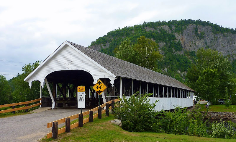
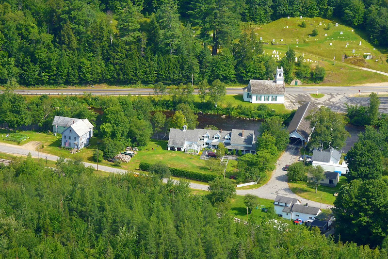
Anyone who has been to Stark, NH could not help but notice the huge cliff that dominates the area of the village near the covered bridge. Below is a snapshot for those who might not have been there.
As I indicated in the title, this spot is named "Devil's Slide". However, in no way does this spot remotely resemble a slide. It's a definite cliff! Probably there is a fascinating history behind this name. Perhaps some VFTT person can shed some light?
There is a very interesting book about Stark, NH written by Allen V. Koop. It's entitled: "Stark Decency: German Prisoners of War in a New England Village". Contained in this book is the following sentence which aptly describes the Devil's Slide.
"Above Stark's weather-beaten, white-painted covered bridge and little white church, the 750-foot dark granite cliff of Devil's Slide forms an imposing, even ominous backdrop for the quite town."
For quite some time, it's been in the back of my mind to hike to the top of this cliff. I knew that this would not be a long hike, and so I knew I'd choose a day when I didn't have long to hike. It's a very short 45 minute (or less) drive from my home in Bethlehem to Stark. And so, I also knew I could easily drive up there whenever circumstances were right. Well, today (06-Aug), things seem to all come together. I had a short time to hike and the weather looked promising.
Did I just say that the weather looked promising? Almost immediately upon my arrival in Stark, it started to rain!
It rained for a good 20 minutes!
Anyway, before continuing with this Trip Report, I'd like to interject that I always try to be sensitive to NOT posting a hike when I feel that there might be some potential for upsetting the "locals". If I'm bushwhacking to a trailless destination and I come across a herd path/bootleg trail, then in most cases I'll not post the hike for fear of getting someone in trouble, and/or revealing a favorite destination that is used primarily by the local community.
In this particular case, I did not come across anything that resembled a trail until I reached the top of Devil's Slide where there is a definite path that runs along the edge of the cliff. And so, if there is a herd path/bootleg trail leading to the top of Devil's Slide, then the secret is still safe! I don't know where it is, or from where it originates! I bushwhacked to the top using a route that only involved public land. I also parked on public land (as confirmed with a nearby landowner).
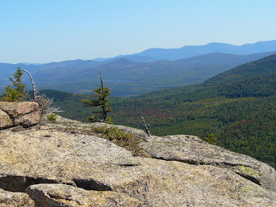
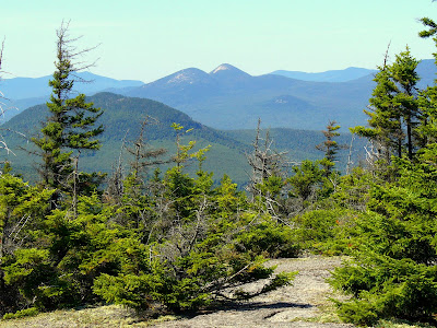
Okay, I frequently don't know if I'm the only person on earth who has NOT visited a particular spot. So, the photos below are for anyone who hasn't been to the top of Devil's Slide and who might be curious as to what can be seen from there.
As you might suspect, there's a very nice view of picturesque Stark village.
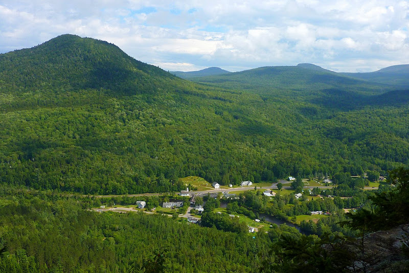
Below is a zoomed shot of a portion of this quintessential New England village.
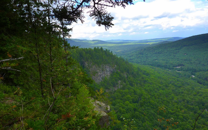
And lastly, the snapshot below looks eastward across the cliff face of Devil's Slide.
This trek is definitely something that won't fill your entire day. It's something to do in combination with something else, or when you happen to be nearby to Stark and have about 2 hours worth of time to fill in.
1HappyHiker
As I indicated in the title, this spot is named "Devil's Slide". However, in no way does this spot remotely resemble a slide. It's a definite cliff! Probably there is a fascinating history behind this name. Perhaps some VFTT person can shed some light?
There is a very interesting book about Stark, NH written by Allen V. Koop. It's entitled: "Stark Decency: German Prisoners of War in a New England Village". Contained in this book is the following sentence which aptly describes the Devil's Slide.
"Above Stark's weather-beaten, white-painted covered bridge and little white church, the 750-foot dark granite cliff of Devil's Slide forms an imposing, even ominous backdrop for the quite town."
For quite some time, it's been in the back of my mind to hike to the top of this cliff. I knew that this would not be a long hike, and so I knew I'd choose a day when I didn't have long to hike. It's a very short 45 minute (or less) drive from my home in Bethlehem to Stark. And so, I also knew I could easily drive up there whenever circumstances were right. Well, today (06-Aug), things seem to all come together. I had a short time to hike and the weather looked promising.
Did I just say that the weather looked promising? Almost immediately upon my arrival in Stark, it started to rain!
It rained for a good 20 minutes!
Anyway, before continuing with this Trip Report, I'd like to interject that I always try to be sensitive to NOT posting a hike when I feel that there might be some potential for upsetting the "locals". If I'm bushwhacking to a trailless destination and I come across a herd path/bootleg trail, then in most cases I'll not post the hike for fear of getting someone in trouble, and/or revealing a favorite destination that is used primarily by the local community.
In this particular case, I did not come across anything that resembled a trail until I reached the top of Devil's Slide where there is a definite path that runs along the edge of the cliff. And so, if there is a herd path/bootleg trail leading to the top of Devil's Slide, then the secret is still safe! I don't know where it is, or from where it originates! I bushwhacked to the top using a route that only involved public land. I also parked on public land (as confirmed with a nearby landowner).
Okay, I frequently don't know if I'm the only person on earth who has NOT visited a particular spot. So, the photos below are for anyone who hasn't been to the top of Devil's Slide and who might be curious as to what can be seen from there.
As you might suspect, there's a very nice view of picturesque Stark village.
Below is a zoomed shot of a portion of this quintessential New England village.
And lastly, the snapshot below looks eastward across the cliff face of Devil's Slide.
This trek is definitely something that won't fill your entire day. It's something to do in combination with something else, or when you happen to be nearby to Stark and have about 2 hours worth of time to fill in.
1HappyHiker
Last edited: