A Short Hike to Pine Mountain in Gorham (19-Oct-2010)

vftt.org

Help Support vftt.org:

This site may earn a commission from merchant affiliate links, including eBay, Amazon, and others.

1HappyHiker

Well-known member
Joined
Jan 18, 2007
Messages
1,973
Reaction score
405
Location
Bethlehem, NH
Although many of my recent hikes have been small in terms of hiking miles, some of them have produced a decent size payoff. One such hike was a trek to Pine Mountain in Gorham.

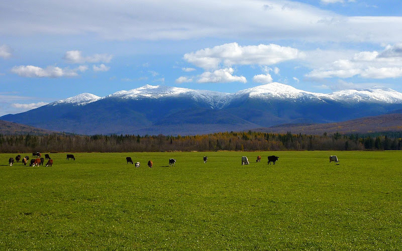
While en route to the trailhead from my home in Bethlehem, I took a short side-trip onto Route 115A to stop at Jefferson Meadows. I wanted to take a few photos of the snow-capped Presidentials with cows grazing in the meadow where the grass is still lush and green. To me, this is always such an awesome vista, and it somewhat reminds me of a scene from "Heidi" (the classic children's novel by Johanna Spyri).

P1070690.JPG

Since it was already mid afternoon and daylight hours are now at a premium, my time at Jefferson Meadows was brief. I needed to keep moving in the direction of the trailhead! In Randolph, I left Route 2 and turned onto Pinkham B (Dolly Copp) Road for the 2.4 mile drive to the trailhead. I drove slowly over this rough road to try to preserve the 4-wheel alignment I'd just paid to have done.:eek:

From the trailhead, my route included the 0.9 mile walk along Pine Mountain Road to hook up with the Ledge Trail which goes over the south cliff of Pine Mountain en route to the summit. From the summit, I followed the Pine Mountain Trail to eventually hike up the unmarked trail to Chapel Rock.

One of the highlights of the Pine Mountain hike is the close-up views of high peaks in the Presidential Range. I could see the magnificent snow-capped mountaintops with the naked eye. However, since it was mid-afternoon, the sun was already low in the western sky, and unfortunately this is where the Presidential Range is located in relation to Pine Mountain. Trying to get decent photos while shooting into the sun is frustrating, at least for someone with my skill level, and with using a simple point & shoot camera. (By the way, I won't feel like my thread is being hijacked if anyone wants to reply by including their photos of the Presidential peaks taken from Pine Mountain.)

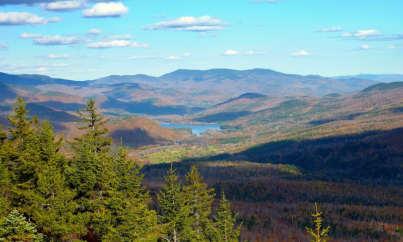
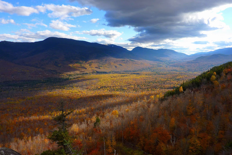
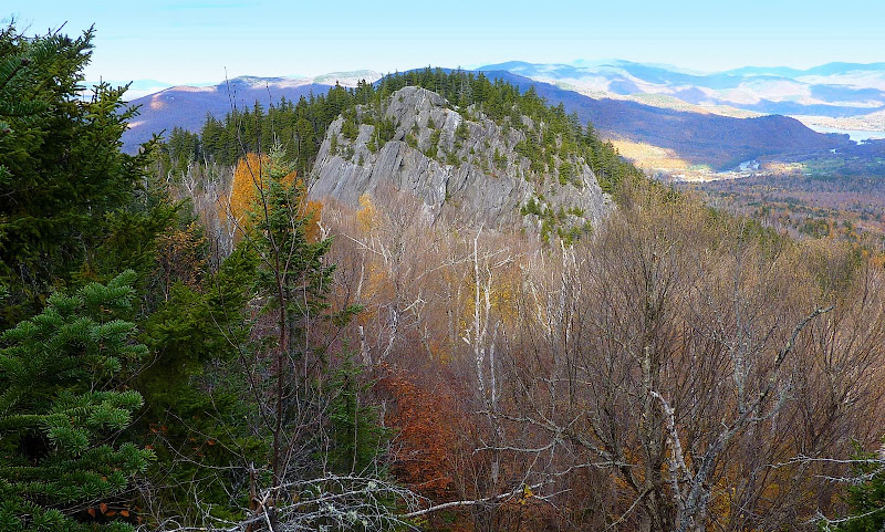
Although I was unable to capture worthwhile images of the Presidentials, I was able to get some decent photos of other sights to be seen from Pine Mountain. Shown below are a few of those snapshots.

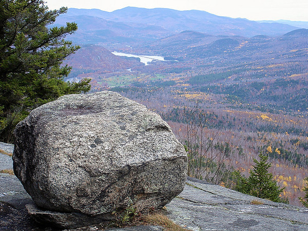
Looking over the Androscoggin River toward peaks in the southern Mahoosucs
P1070716.JPG

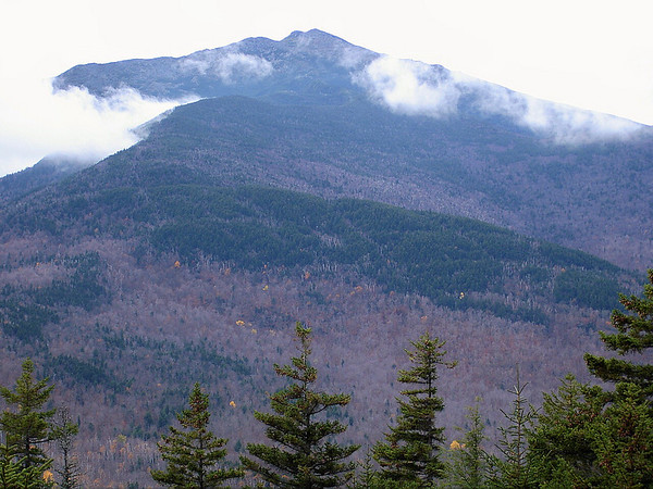
Funky snapshot of Carter Range caused by cloud shadows
P1070736.JPG

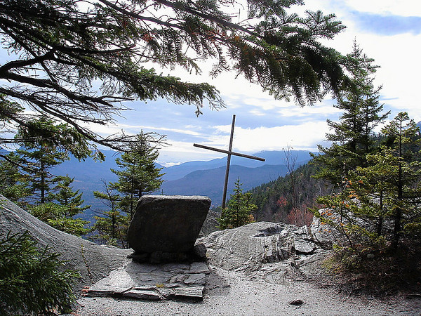
Chapel Rock partially illuminated
P1070726.JPG

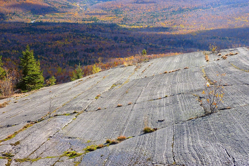
Glacial striations on south cliff of Pine Mountain
P1070711.JPG

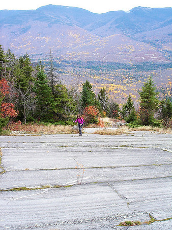
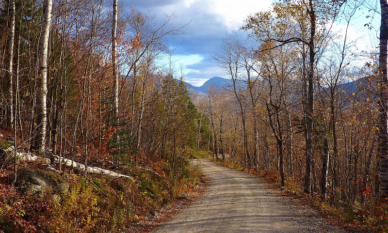
A picturesque view from Pine Mountain Road
P1070746.JPG

I've never done this hike in the winter once the Pinkham B Road is gated. But, it could be done from the trailhead located in the village of Gorham. However, I've never hiked that particular route (winter or summer), and so I'd be interested in reading any comments from anyone who has.

As I said at the beginning, this was a very short hike. But, I still felt amply rewarded by the overall experience, especially considering the views I got for such a small amount of time and effort.

1HappyHiker
 
Pine Mt.

excellent as always!! the trail from the Gorham side I find is ok with different terrain and vegetation..once you hit the power line, bear right for a while and look left where the trail goes into the woods again..winter, you can't get into the actual parking spot as the road is not plowed to the sandpit..like it because you have about 3 viewpoints including Chapel Rock, until you reach the ledges, including a nice shelter, and of course, the Horton Center, which is an interesting settlement!! Lefty E
 
Last edited:
John,
Beautiful......your first photo also reminds me of the Swiss Alps or a scene from Sound of Music. We ventured to Pine Mountain in October 2007 as we were looking for a short hike, saw it on the map and decided to give it a try.
We were pleasantly surprised at the incredible views this small mountain afforded for a little effort. One strange thing happened. When we reached Chapel Rock we heard a beep, beep, beep and thought that it was the camera. It turned out being the cell phone. Apparently the cell tower zapped the phone and it died.:confused:
Never had that happen on any moutain before.

Donna:)
 
I dont know if you made it to the third summit but the view west up Rt 2 from the new lean to is quite impressive. To get to it follow the path north on the east side of the dining hall and follow it to its end.

I hike the north side up from the spring house in the winter. There used to be two trails the climbed to the summit from the RR station adjacent to the bottling plant. This area can be access via the Mineral Spring road in Gorham. The landowner did have the area posted the last time I went through there a year ago, but in actuality its a town road all the way down to the spring. When you reach the end of the pavement bear left and there is a gated old road that runs south, when you hit the viewpoint, follow the road down to the right to the spring pool and then out to the RR track.
 
excellent as always!! the trail from the Gorham side I find is ok with different terrain and vegetation..once you hit the power line, bear right for a while and look left where the trail goes into the woods again..winter, you can't get into the actual parking spot as the road is not plowed to the sandpit..like it because you have about 3 viewpoints including Pulpit Rock, until you reach the ledges, including a nice shelter, and of course, the Horton Center, which is an interesting settlement!! Lefty E
Lefty, many thanks for the useful info . . . especially the bit about the road not being plowed all the way to the sandpit.
So where do you park in the winter? Maybe someplace on Promenade Street?
John,
Beautiful......your first photo also reminds me of the Swiss Alps or a scene from Sound of Music. We ventured to Pine Mountain in October 2007 . . . One strange thing happened. When we reached Chapel Rock we heard a beep, beep, beep and thought that it was the camera. It turned out being the cell phone. Apparently the cell tower zapped the phone and it died . . . here's a few photos we took several years ago when we did Pine Mountain.
Donna & Mike: Thanks for posting your Pine Mountain photos! Very nice!
And regarding the incident with your cell phone . . . hmmm! Very strange indeed!
GORGEOUS photos of the Presidentials with the cows grazing in the foreground!
I don't know if the Nestle/Carnation folks still use the promotional phrase, "Carnation Condensed Milk, the milk from contented cows". However, what cow wouldn't be "contented" to graze in a setting such as shown in the first photo of this report?:)
I dont know if you made it to the third summit but the view west up Rt 2 from the new lean to is quite impressive. To get to it follow the path north on the east side of the dining hall and follow it to its end.
Thanks Peakbagger for the info.
Regarding the "third summit" that you mentioned, I just checked a topographic map. Is it that bump which is located nearly due west of Chapel Rock? If so, then nope I definitely didn't make it to that spot. However, if you confirm that the "third summit" is the bump due west of Chapel Rock, then I'll definitely make it a point to go there the next time I'm on Pine Mtn (perhaps this winter!).
 
John, those are some superb photos, especially the first one. A friend and I were looking at that same scene from the cliffs of Owl's Head the very same day. However, I much prefer the cow and grass foreground of your shot to anything I was able to capture! Definitely one of the best times of the year to be out in the Whites. Thanks for sharing! :)
 
Pine

last year i drove by Promenade St. towards the pit and the road was not plowed, but there appeared to be spots to park near the cemetary...if you go maybe leave a note in your windshield..did you see the shelter on the east side of the mt?? and i did not know there had been other ways to get up there and another viewpoint on the west side, thanks to peakbagger we ll have to check that out sometime too! When i was an extremely young kid, I actually went into the active fire tower on Pine Mt. (but was old enough to remember it!!!!)
 
Regarding the "third summit" that you mentioned, I just checked a topographic map. Is it that bump which is located nearly due west of Chapel Rock? If so, then nope I definitely didn't make it to that spot. However, if you confirm that the "third summit" is the bump due west of Chapel Rock, then I'll definitely make it a point to go there the next time I'm on Pine Mtn (perhaps this winter!).
__________________


Yup, that is the one, there is a fairly recent vintage lean to up there, but given its westerly exposure I expect it would be a windy spot to camp and would fill up with snow in the winter.

If folks want to park in the winter for the trail head in Gorham, please dont park on the spur off of Promenade street immediately adjacent to the cemetary, it acts as a private driveway for two homes and usually isnt real wide. There is a public parking lot adjacent to the RR tracks just down church street.

Do note that Pine Mountain gets a lot of snowmachine traffic in the winter from Pinkham B road and the snowmachine trail is up the road from Pinkham B. If you do snow shoe in the area watch out for snowmachines. A particulary risky section is the turn off from the road up near the dining hall, it is a steep grade and the snowmachines have to "gun it" to get up this section and its not particularly wide in spots. The trail from Gorham coincides with a snowmachine trail down low for about 1/4 of a mile, so also watch out. That is why I do the approach from the mineral spring road with a compass. Its mostly open hardwoods and if you follow the drainage its brings you right up to near the top with less snowmachine issues.
 
As usual, nice photos. Whenever Liz and I are heading over to Waumbek, we make a point to stop and take a few shots of the Presis from those meadows. Keep em coming John.
 
Nice photos! I've played violin at a service at Chapel Rock, and hiked around there and down to Gorham while staying at Horton. There is a fantastic view of Madison from the back porch.
 
John, those are some superb photos, especially the first one. A friend and I were looking at that same scene from the cliffs of Owl's Head the very same day. However, I much prefer the cow and grass foreground of your shot to anything I was able to capture! Definitely one of the best times of the year to be out in the Whites. Thanks for sharing! :)
Thanks Chris! It's always special to get a compliment from a real photographer such as yourself!
. . . did you see the shelter on the east side of the mt??
Yes, I did. It appears to be a fairly recent structure.
1HappyHiker said:
Regarding the "third summit" that you mentioned, I just checked a topographic map. Is it that bump which is located nearly due west of Chapel Rock?
Yup, that is the one . . .
If folks want to park in the winter for the trail head in Gorham, please dont park on the spur off of Promenade street immediately adjacent to the cemetary, it acts as a private driveway for two homes and usually isnt real wide. There is a public parking lot adjacent to the RR tracks just down church street . . . Do note that Pine Mountain gets a lot of snowmachine traffic in the winter . . .
Thanks for confirming the location of the "third summit". And, thanks for the info about the winter parking situation at the trailhead in Gorham, and also for the advice about snowmachine traffic on Pine Mountain.
As usual, nice photos. Whenever Liz and I are heading over to Waumbek, we make a point to stop and take a few shots of the Presis from those meadows. Keep em coming John.
Great spot, isn't it!:)
Nice photos! I've played violin at a service at Chapel Rock, and hiked around there and down to Gorham while staying at Horton. There is a fantastic view of Madison from the back porch.
Glad you liked the photos!
Imagine this view being your bus stop every morning....some of us don't have to!:D
Wow Scott! So your school bus stop was that awesome spot with the cows in the meadow and the Presidentials in the background? Amazing!
Based upon some of your writings, I'd guess that even when you were a young school boy, you had a deep appreciation for the beauty of that spot, and didn't just take it for granted.
 
Last edited:
Wow Scott! So your school bus stop was that awesome spot with the cows in the meadow and the Presidentials in the background? Amazing!
Based upon some of your writings, I'd guess that even when you were a young school boy, you had a deep appreciation for the beauty of that spot, and didn't just take it for granted.

Great spot for a view, terrible wind though, I swear the wind pushed the bus down to us as soon as it exited Stag Hollow Road. In the winter it would come howlin' down 115. When the Towle's lived in that big white farmhouse we would just walk up to their spot. When they moved away, we stood at the intersection of Valley Road, 115, & what they now call Israel's River Road. Sunrises in November and December were quite the sight. It was one of the instances when it was good not to arrive to early for the bus. From the angle, it looks like you took it just across from the gated bridge that leads to, what we called, "Hastings Pond".
 
From the angle, it looks like you took it just across from the gated bridge that leads to, what we called, "Hastings Pond".
Scott, I can't seem to find Hastings Pond on the map. Perhaps that's a local name for that particular body of water?:confused:
Anyway, the photo of the cows in the meadow with the Presidentials in the background was taken from Route 115A a few tenths of a mile north of the Whipple Road intersection. Is Hastings Pond nearby to that location?
Incredible photos, I think some of the nicest of the year for you. :)
Thanks Matt for the compliment and for taking a moment to post a reply.
 
Yea John, its just a local reference. Over that chained bridge that crosses Stag Hollow Brook is a three unit home. Its just a summer place for a family that lives in MA. They were always nice to us and let us fish in the pond up to a certain amount. Also a fun place for us to swim, they had a diving board built onto the dock. A looooong time ago the owners took a small feeder and diverted into their pond.

Its not on any map because its not a recognized body of water. On Google Earth its 44 22' N & 71 26' W.
 
John,
How lovely! Someone at our campground mentioned Pine Mtn a few weeks ago and spoke very highly of it. I hope we have a chance to check it out.
Jimmy Legs & Little d - Thanks for adding your photos as well.
geri
 
Top