Amicus
Well-known member
- Joined
- Aug 28, 2005
- Messages
- 1,145
- Reaction score
- 112
Nov. 8: Kaibab Trail to Cedar Point. The Kaibab is the newer and less eroded main trail from the popular and populous South Rim of the Canyon to the Colorado River, some 6.5 miles in distance and one mile in depth below. Most of my fellow-hikers on the early Hikers Express bus from Grand Canyon Village were back-packers planning two or more day hikes to the River, either returning to the South Rim by the Bright Angel Trail or continuing on to the North Rim - a 22-mile hike which would require a 220-mile car-spot and the risk that the North Rim road would be closed by snow - a possibility from mid-October on.
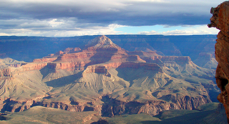
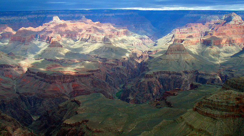
My modest objective was Cedar Point Ridge, a spur to a point a few hundred yards off the Kaibab, after a descent of 1.5 miles. We had arrived in the dark the previous evening, so the view north from the Rim at the Trailhead was my first of GC since a family camping trip in '65. Great vistas always excite me but few have left me breathless, as this did. Halfway down, I reached Ooh-Aah Point, and this view north to Brahma Temple:
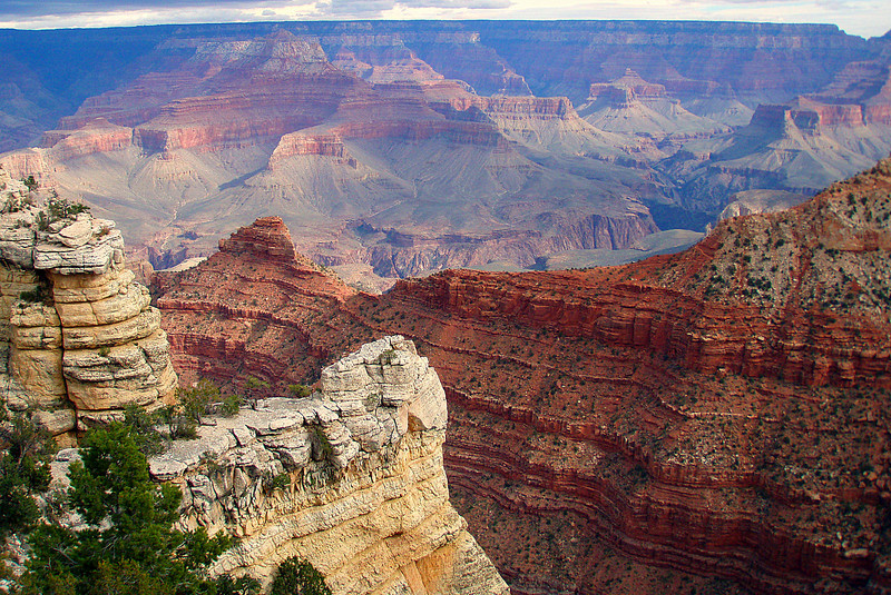
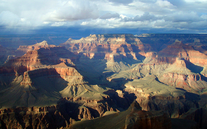
This view of Kaibab Ridge from the next point to the west shows Ooh-Point Point on the right and Cedar Ridge in the middle. That's O'Neill Butte on the left:
My 3-mile roundtrip left me plenty of time to explore the several miles of the Rim Trail heading west, back to the Village. I hadn't known that the more striking buttes and pinnacles are named after gods from the world's Pantheon, as in Isis Temple:
and Buddha (left) and Brahma Temples:
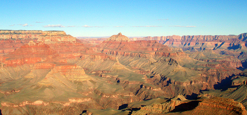
After lunch, my wife and I followed the Rim Trail west from the Village to Maricopa Point, and I turned around at Hopi Point. We dodged some fierce little outbursts of hail and I hiked through freezing rain for the last hour, but consistently interrupted by bursts of sunlight. Here is a view north from Hopi Point:
The rest of my pix from these hikes are here.
Nov. 9: Bright Angel and Plateau Point Trails; Shoshone Point. We awoke Tuesday morning to temperatures in the low teens and the clearest skies I have seen in at least a few years. I had selected the Bright Angel Trail - the South Rim's most popular for well over a century - for a 4.5 mile hike to Indian Garden, which is a remarkable oasis of green grass, a babbling creek and cottonwood trees, amidst the arid beauty of the desert landscape. From there, I would take the 1.6 mile spur to Plateau Point. On hikes like this, the views back to the trailhead often equal those looking ahead:
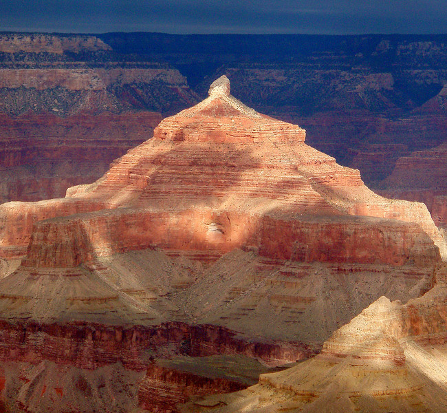
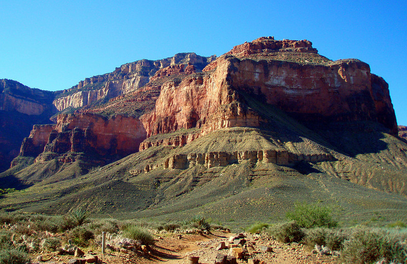
Plateau Point looks flat from the Rim but undulated a couple of hundred vertical feet before reaching its end at a cliff that drops over 1,500 feet to the Colorado River. You are over 3,100 feet below the Rim, so there are good views up, as in this of Battleship Butte:
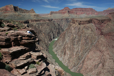
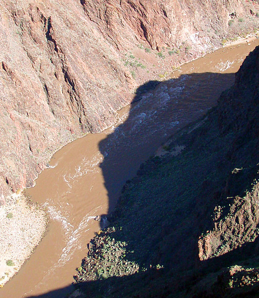
and down to the River, which can be spotted only fitfully from the Rim:
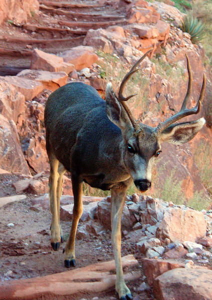
We saw many elk and deer in the course of our trip and on my hike back a curious young male came within five feet of me, before bounding off in pursuit of some grass:
This view back to the north gives you a decent perspective on Indian Garden and the Plateau Point Trail:
This 12.5-miler would be a killer in July, when temperatures in the Inner Canyon often exceed 100F and there is hardly any shade, but I had great conditions for it and was back to our cabin in under six hours. I have been around long enough to be wary of superlatives, but I am tempted to call this the best route I have ever hiked.
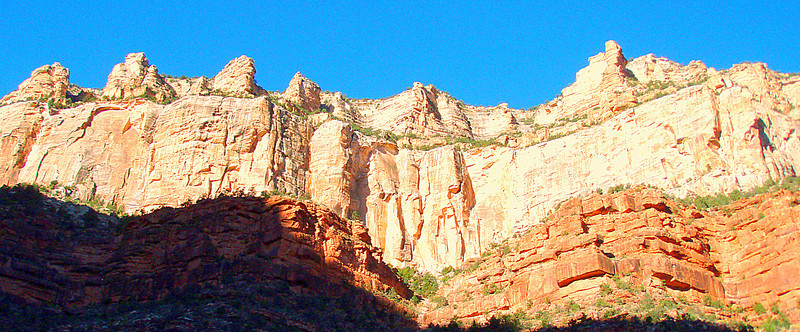
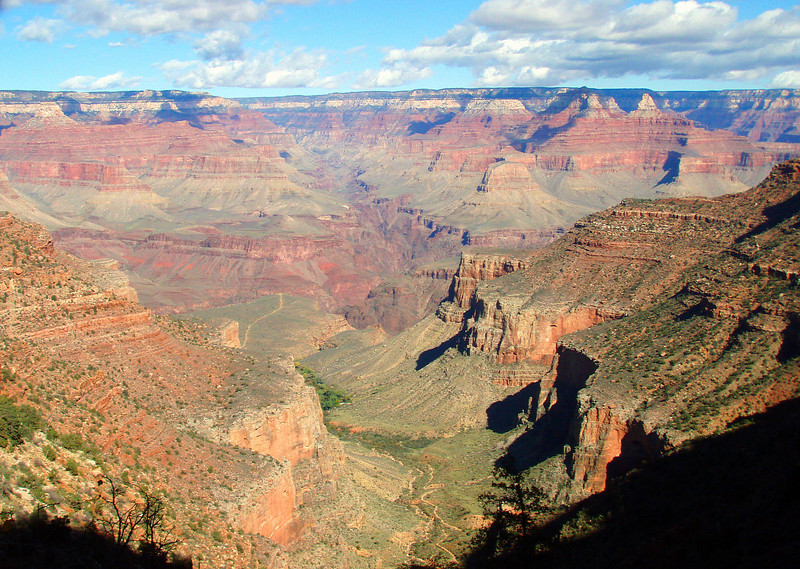
The two of us then drove east to a trail you would never know about unless you had been informed, as we were by a little book my wife had acquired - Best Easy Day Hikes - Grand Canyon NP. The one-mile dirt road/trail to Shoshone Point starts at a closed gate off the main road east that is unsigned and inconspicuous. The Point protrudes needle-like out into the Canyon, east of the other popular Points, and it was a delight to have it entirely to ourselves. Yet more great views, as in this of Vishnu Temple:
My other pix from these hikes are here. The next morning, we devoted our few remaining hours to exploring the west end of the Rim Trail and you can see those pix here. We also explored Hoover Dam on our drive out from Las Vegas and the spectacular new Bridge that bypasses it on our drive back, and you can see those pix here.
My modest objective was Cedar Point Ridge, a spur to a point a few hundred yards off the Kaibab, after a descent of 1.5 miles. We had arrived in the dark the previous evening, so the view north from the Rim at the Trailhead was my first of GC since a family camping trip in '65. Great vistas always excite me but few have left me breathless, as this did. Halfway down, I reached Ooh-Aah Point, and this view north to Brahma Temple:
This view of Kaibab Ridge from the next point to the west shows Ooh-Point Point on the right and Cedar Ridge in the middle. That's O'Neill Butte on the left:
My 3-mile roundtrip left me plenty of time to explore the several miles of the Rim Trail heading west, back to the Village. I hadn't known that the more striking buttes and pinnacles are named after gods from the world's Pantheon, as in Isis Temple:
and Buddha (left) and Brahma Temples:
After lunch, my wife and I followed the Rim Trail west from the Village to Maricopa Point, and I turned around at Hopi Point. We dodged some fierce little outbursts of hail and I hiked through freezing rain for the last hour, but consistently interrupted by bursts of sunlight. Here is a view north from Hopi Point:
The rest of my pix from these hikes are here.
Nov. 9: Bright Angel and Plateau Point Trails; Shoshone Point. We awoke Tuesday morning to temperatures in the low teens and the clearest skies I have seen in at least a few years. I had selected the Bright Angel Trail - the South Rim's most popular for well over a century - for a 4.5 mile hike to Indian Garden, which is a remarkable oasis of green grass, a babbling creek and cottonwood trees, amidst the arid beauty of the desert landscape. From there, I would take the 1.6 mile spur to Plateau Point. On hikes like this, the views back to the trailhead often equal those looking ahead:
Plateau Point looks flat from the Rim but undulated a couple of hundred vertical feet before reaching its end at a cliff that drops over 1,500 feet to the Colorado River. You are over 3,100 feet below the Rim, so there are good views up, as in this of Battleship Butte:
and down to the River, which can be spotted only fitfully from the Rim:
We saw many elk and deer in the course of our trip and on my hike back a curious young male came within five feet of me, before bounding off in pursuit of some grass:
This view back to the north gives you a decent perspective on Indian Garden and the Plateau Point Trail:
This 12.5-miler would be a killer in July, when temperatures in the Inner Canyon often exceed 100F and there is hardly any shade, but I had great conditions for it and was back to our cabin in under six hours. I have been around long enough to be wary of superlatives, but I am tempted to call this the best route I have ever hiked.
The two of us then drove east to a trail you would never know about unless you had been informed, as we were by a little book my wife had acquired - Best Easy Day Hikes - Grand Canyon NP. The one-mile dirt road/trail to Shoshone Point starts at a closed gate off the main road east that is unsigned and inconspicuous. The Point protrudes needle-like out into the Canyon, east of the other popular Points, and it was a delight to have it entirely to ourselves. Yet more great views, as in this of Vishnu Temple:
My other pix from these hikes are here. The next morning, we devoted our few remaining hours to exploring the west end of the Rim Trail and you can see those pix here. We also explored Hoover Dam on our drive out from Las Vegas and the spectacular new Bridge that bypasses it on our drive back, and you can see those pix here.
Last edited:
")