A Loop around King Ravine, Plus a Side-Trip to Mt Adams: (21-Jun-2011)

vftt.org

Help Support vftt.org:

This site may earn a commission from merchant affiliate links, including eBay, Amazon, and others.

1HappyHiker

Well-known member
Joined
Jan 18, 2007
Messages
1,973
Reaction score
405
Location
Bethlehem, NH
What delightful weather it was on 21-June! Mostly sunny skies, low humidity, and the air temperature and wind were both moderate! To make the most of these terrific conditions, I wanted to do a trek that would take me above tree-line, and would incorporate a trail that I'd never hiked.

The hike I decided to do was a 9.3 mile loop that goes around the tops of the walls surrounding the King Ravine, plus this trek also incorporated a trip to the summit of Mt. Adams. And, I was able to include a trail in this loop that was new to me, i.e. the Spur Trail. This trail ascends the west wall of King Ravine. It leads from the Randolph Path (just above the junction with the King Ravine Trail) to Lowe's Path (just below Thunderstorm Junction).

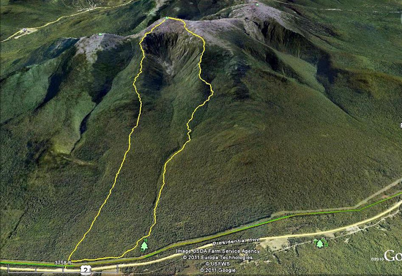
Shown below is a GoogleEarth image of King Ravine with my route highlighted in yellow. The trails involved in my loop were: The Link; Amphibrach; Randolph Path; Spur Trail; Lowe's Path; Gulfside Trail; Air Line Trail.

Route.jpg

I realize that many folks are busy and/or uninterested in this type of hike, and therefore only one photo is shown below. If you have an interest in reading more about this hike and seeing a few more photos, then please click HERE to access my Blog.

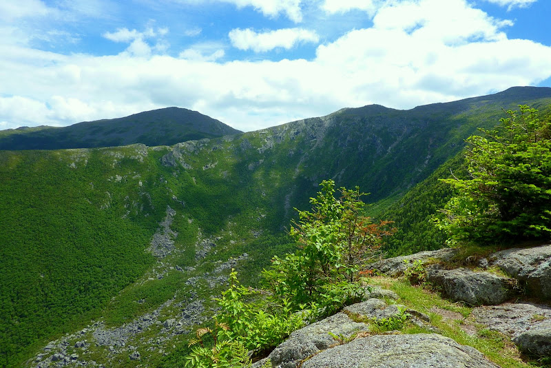
King Ravine (as seen from Upper Crag viewpoint along the Spur Trail)
P1030215.JPG
 
Last edited:
John, great report and photos as usual. Nice flower collage. One of the nice things about this time of year is how lush green everything is. Also, because of how high the sun is this time of year, the pictures of Mt Washington taken from the northern presidentials come out nice...all too often we're shooting into the low(er) sun so the sky doesn't come out well.

Question for you. Do you mind explaining how you got that image of your hike in Google Earth? Was it a GPS track upload to Google Earth, or some other creative trickery? I like it, very cool.
 
Google Earth will open .GPX files; just use whatever method is necessary to get a .GPX file either off your GPS or exported out of your GPS' software, and you can do a simple File->Open in Earth.
 
John, great report and photos as usual. Nice flower collage. One of the nice things about this time of year is how lush green everything is. Also, because of how high the sun is this time of year, the pictures of Mt Washington taken from the northern presidentials come out nice...all too often we're shooting into the low(er) sun so the sky doesn't come out well.

Question for you. Do you mind explaining how you got that image of your hike in Google Earth? Was it a GPS track upload to Google Earth, or some other creative trickery? I like it, very cool.
Google Earth will open .GPX files; just use whatever method is necessary to get a .GPX file either off your GPS or exported out of your GPS' software, and you can do a simple File->Open in Earth.
Great pictures, gotta love Adams.

Thanks guys for your replies!

@Billy: The reply to your question as provided by MichaelJ is factual and true. However, in this particular instance I used a method that was similar but yet different from what he described. I went to the WMG Online website (subscription required) and set up my route. The software will highlight the trails that you specify, and then can convert your route to a KML file which can then be displayed in GoogleEarth. Once the yellow highlighted route is displayed in GoogleEarth, you can go to the File menu in Google Earth and choose to save the image seen on your screen as a JPEG file. And of course, once you have your JPEG file saved, you can post it on a website, or whatever!

@MichaelJ: Thanks for posting the bit about the .GPX files . . . much appreciated!

@TDawg: Yup . . . the main Adams summit is nice. Actually, the entire Adams family (Abigail, and all the little Adams) are also nice!
 
Last edited:
Great report as always John. Adams is one of the peaks still not checked off our list and although my thought had been for a "more common" route from Appalachia this one looks just awesome!

I love using the WMG Online combined with Google Earth to visualize routes in the Whites. I've been a WMG Online subscriber since it was introduced and always thought it was well worth the price. Google Earth makes it twice as good.
 
Nice one John. We did something in that area last weekend- going up Kings Ravine, down to Madison hut, up/down Madison, and then up Star Lake tr to Adams, and down Airline.
Kings Ravine is a very picturesque area. The Spur trail down to Craig camp and Knights Castle has some fantastic views. The Northern Presi's are the bomb....

Petch
 
Top