
1HappyHiker
Well-known member
We've recently had family visiting us. Although we did a couple of short, mild-mannered hikes, it has been well over a week since I've been free to do the type of hiking that is customary for me. With all the hubbub of seeing everyone off, plus the time it took to formulate a hiking plan and gather my gear, it was already late morning (nearly the crack of noon!) on 07-July before I was on the trail.
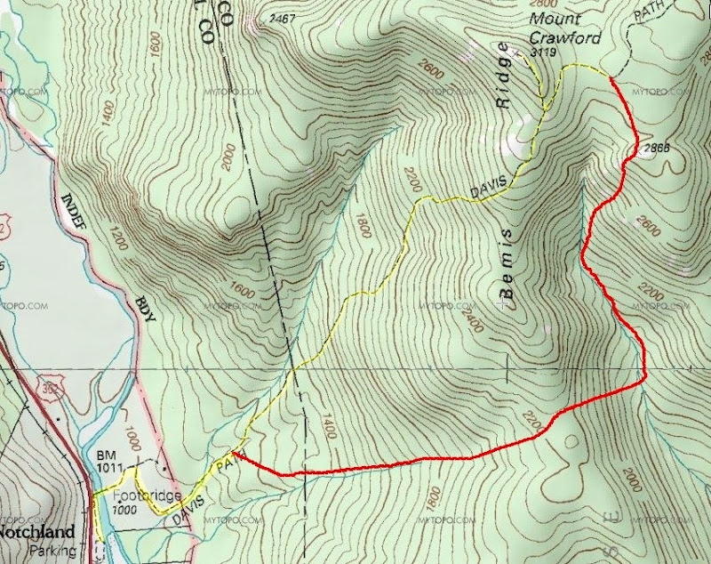
For quite awhile, I've wanted to check out the Razor Brook valley and see if I could find any remnants of the Razor Brook Trail that was abandoned in the early 1960s. And so, my game plan was to hike a short distance up the Davis Path and then bushwhack eastward and cross over the Bemis Ridge to the Razor Brook Valley. From there, I would trek northward up the valley to the little unnamed 2,866 ft peak. From that peak, I'd then bushwhack to the Davis Path, take a side trip to Mt. Crawford, and return to my car via the Davis Path.
Shown below is a rough depiction of my route. I say "rough" since I didn't run a GPS track which would've shown my exact route. I only used my GPS sporadically to confirm that I hadn't run too far amuck from my intended course. (The bushwhack portion is shown in red, and the on-trail portion is highlighted in yellow.)
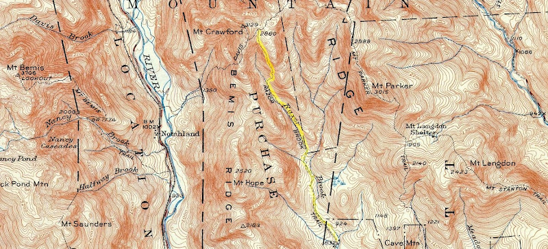
The next photo shows a portion of a topographic map from 1950. The old Razor Brook Trail is highlighted in yellow. (This trail began at a point about 2.5 miles north of Bartlett and terminated at the Davis Path just a short distance northeast of Mt. Crawford.)
This adventure went very well. I was able to complete the approximate 5 mile hike (at a leisurely pace) in less than 6 hours. The bushwhack portion of my trek was predominately through open woods. The descent off the east side of the Bemis Ridge was steep, but certainly manageable. The roughest spot of the entire journey was the 0.2 mile segment between the 2,866 ft peak and the Davis Path. In this short segment, there were a lot of blowdowns and thick conifers to push through. It made for some very slow-going, but I've encountered conditions that were worse.
Regarding the abandoned Razor Brook Trail, it's likely that I was hiking on segments of it here and there. However, I cannot say with absolute certainty that the corridors that I came across were indeed the old trail. Perhaps they were merely animal trails of some sort. And maybe I simply didn't look hard enough, but I didn't find any old blazes on trees, nor did I see any signs of axe blazes. I wasn't disappointed with finding no confirmatory indicators of the old trail. There were no preconceived notions as to what might be found!
I fully realize that for many folks, this type of hike has limited appeal. So, at this point, some readers might have had enough already! But, for anyone who might have some further interest, you can click HERE to access my Blog which contains a few more details about this trek, plus a few snapshots.
For quite awhile, I've wanted to check out the Razor Brook valley and see if I could find any remnants of the Razor Brook Trail that was abandoned in the early 1960s. And so, my game plan was to hike a short distance up the Davis Path and then bushwhack eastward and cross over the Bemis Ridge to the Razor Brook Valley. From there, I would trek northward up the valley to the little unnamed 2,866 ft peak. From that peak, I'd then bushwhack to the Davis Path, take a side trip to Mt. Crawford, and return to my car via the Davis Path.
Shown below is a rough depiction of my route. I say "rough" since I didn't run a GPS track which would've shown my exact route. I only used my GPS sporadically to confirm that I hadn't run too far amuck from my intended course. (The bushwhack portion is shown in red, and the on-trail portion is highlighted in yellow.)
The next photo shows a portion of a topographic map from 1950. The old Razor Brook Trail is highlighted in yellow. (This trail began at a point about 2.5 miles north of Bartlett and terminated at the Davis Path just a short distance northeast of Mt. Crawford.)
This adventure went very well. I was able to complete the approximate 5 mile hike (at a leisurely pace) in less than 6 hours. The bushwhack portion of my trek was predominately through open woods. The descent off the east side of the Bemis Ridge was steep, but certainly manageable. The roughest spot of the entire journey was the 0.2 mile segment between the 2,866 ft peak and the Davis Path. In this short segment, there were a lot of blowdowns and thick conifers to push through. It made for some very slow-going, but I've encountered conditions that were worse.
Regarding the abandoned Razor Brook Trail, it's likely that I was hiking on segments of it here and there. However, I cannot say with absolute certainty that the corridors that I came across were indeed the old trail. Perhaps they were merely animal trails of some sort. And maybe I simply didn't look hard enough, but I didn't find any old blazes on trees, nor did I see any signs of axe blazes. I wasn't disappointed with finding no confirmatory indicators of the old trail. There were no preconceived notions as to what might be found!
I fully realize that for many folks, this type of hike has limited appeal. So, at this point, some readers might have had enough already! But, for anyone who might have some further interest, you can click HERE to access my Blog which contains a few more details about this trek, plus a few snapshots.
Last edited:
