
PETCH
New member
25 miles in the Dry River Wilderness
Date: Tuesday/Wednesday, August 23/24, 2011
Peaks/Trails: Mt Crawford, Stairs Mtn, Mt Davis, Mt Isolation, Boott Spur, via Davis Path and spur trails, Camel Trail, Dry River Trail
Trail Conditions: Everything below tree line was wet, with the exception of the climb to Mt Crawford. Lots of blowdowns, climb overs, crawl unders on upper section of Dry River trail North of Shelter#3.
Cast of Characters: just me
Commentary
I had been planning another solo backpack trip this summer, and decided upon a semi remote area I've been meaning to check out. I've done parts of the Davis Path, and have been meaning to finish red lining it. The Dry River Trail had also sparked my interest. So, I put together a loop starting at the Davis Path, hiking all the way up to Boott Spur, up and over to Lakes of the Clouds, and taking the Dry River Trail back to rt302. It added up to be about a 25 mile hike, with an overnight at the Isolation tentsite.
So Tuesday morning, I drove up to Crawford Notch, locked my bike to a tree in the woods near the Dry River trailhead, and drove down to the Davis Path. I brought enough food for 3 days, and started with 5 liters of water- which was completely unnecessary. With about 32 lbs total pack weight, I began up the Davis Path at a very gentlemanly start time of 10:30am. The climb to Mt Crawford was putting the hurt on me. 2100ft of gain in 2.5 miles was a rough way to start, but the views were worth it. Whenever I do a backpack trip, I gain more and more respect for thru-hikers that get up and do this for months on end........physically, it's tough on the body.
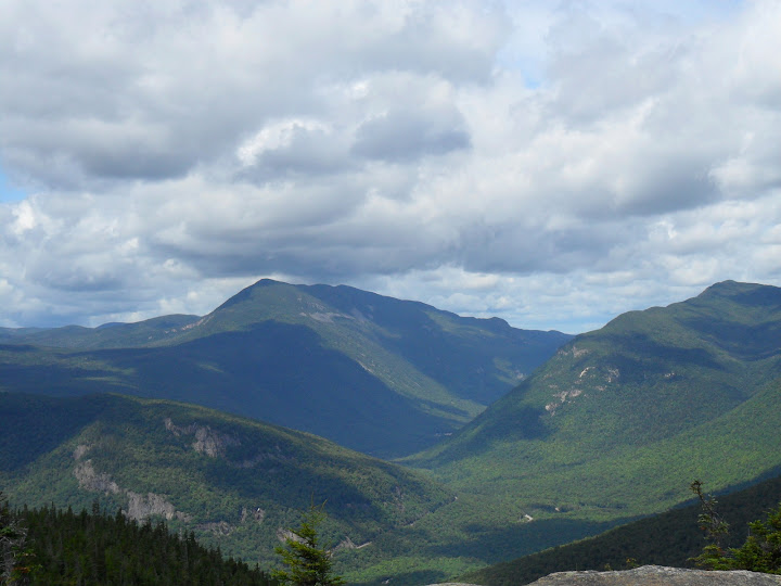
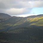
Crawford Notch
Stairs Mtn
From there, I knew the hike over to Stairs was going to be a little wet, and it was. I decided to fore go Resolution (have been to it once), and continued on towards Stairs Mtn. The last time I was here, I do not believe this was a designated tentsite. But, with the Resolution shelter being closed, this makes the most sense I guess. There's room for 2 tents. Fyi- there's a Geocache on top of Stairs Mountain, as well.
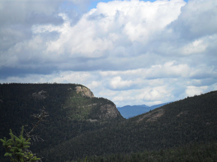
Mt Resolution from Stairs Mtn
From Stairs to Mt Davis, the trail is very wet. More than once I plunged my trail runners into above the ankle deep mud. It was quite a slog. Somewhere in this section I dropped my sunglasses......so I doubled back and found them. An extra .5 miles added on, good times. As wet as things were, there were some very picturesque sections as well. The summits of Davis and Isolation are very similar, with 360 degree views.
After hitting both peaks, I stumbled down to the tentsite area just down the Iso East trail. I could smell a fire going, so I wasn't going to be so "Isolated". It's Tuesday night. That means 50cent wings! Why would anyone be out camping? Turns out there were a few tents jammed in the one area. I found a nearby spot and set up shop. I was beat, after being on the trail for 8 hours. Trail conditions were wet and slow going. I cleaned up, ate, hung my food bag, and was in the sleeping bag by 8:30pm. I put in the ear plugs which really helped in getting a good night sleep.
Next morning I got up around 6:30am or so. Bright sun filtered through the tree canopy. I put on some fresh socks and just slightly damp trail runners. The feet felt great. I made some coffee and oatmeal and picked up camp. l hung my wet socks on the outside of the pack to dry as I hiked. I filtered some water from near the trail as a back up, but I had carried enough to get me to the Lakes hut. I was looking forward to the climb up to Boott Spur. The Davis Path North of Iso East trail to the Glen Boulder trail was new to me. The climb went well, and getting above tree line was food for the soul. This is a great area to hike.
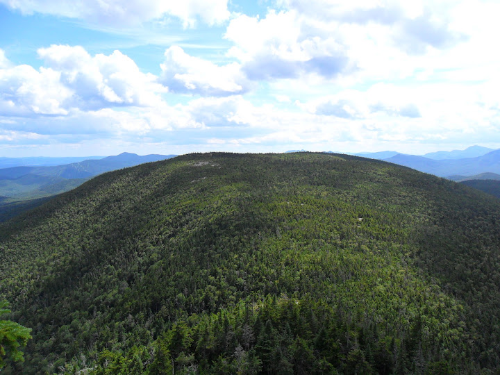
Davis Path between Boott Spur and Camel Trail
Then I descended down to Lakes of the Clouds Hut to refill on water, and see what was available for fresh "eats". Split pea soup? I was horrified, but the young lady assured me that it was real good. Two bowls later, I agreed. One of the hut crew walked in carrying a pack board with a total weight of 105lbs! I felt like such a Sally (no offense to anyone named Sally!) Imagine coming up the Ammo trail with that weight? Sweet Moses
Lower Lake with Washington
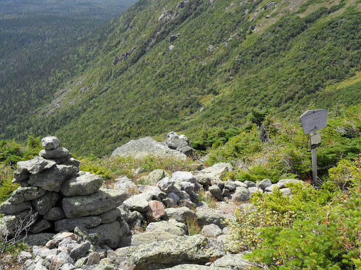
Well, times a wasting, and I got a lot of miles to go. So, off again up to the top of Oaks Gulf. I was now on virgin trail for the rest of the hike, and was looking forward to exploring the Dry River Wilderness valley. The climb down into Oaks Gulf yielded fantastic views of the Southern Presi's and down into the valley. It was pretty wet, and at times the trail and run-off were the same. It was slippery and slow going as I entered the woods down below.
Top of Oaks Gulf
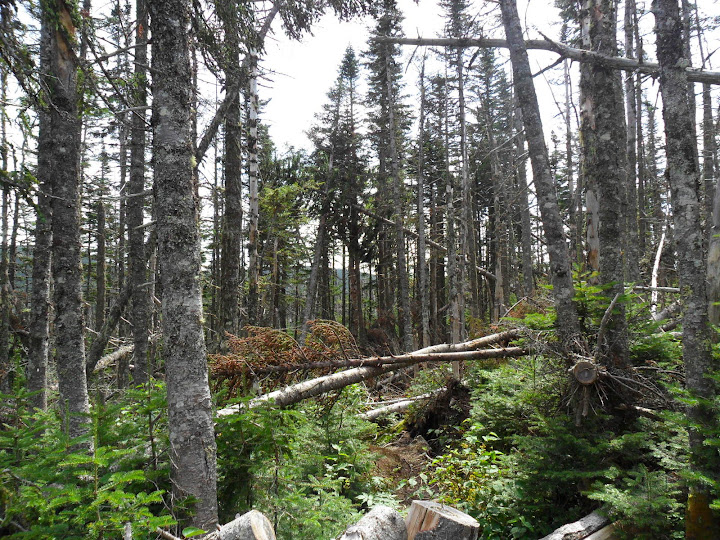
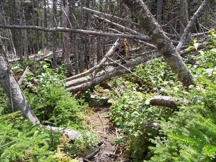
I really got the feeling like I was in the middle of nowhere. I don't think the upper section of the Dry River trail sees a lot of hikers. Very few footprints. The amount of blowdowns was impressive. It's kinda like Hurricane Irene already hit this place. Not just a tree here and there. There were sections where 3-6 trees had all fallen together. It was blowdown alley. Lots of crawl unders, and climb overs. Too many to count. The trail had a couple sections that were difficult to follow.
Yup, that's the trail, have fun in the land of blow downs!
If I were the trail maintainer, I would move to Florida...
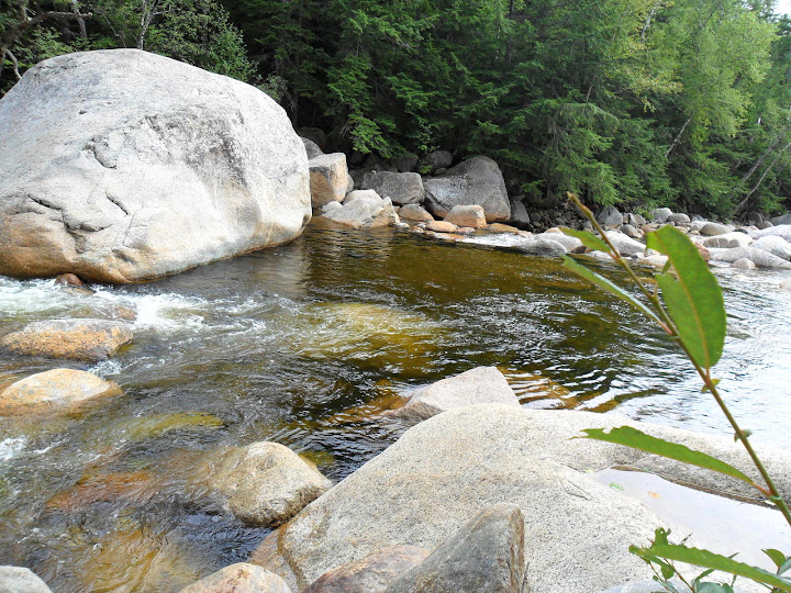
I don't think I could hike more than 1mph until I hit Dry River Shelter #3. The shelter was in awesome shape. Tons of butterflies hanging around. It was still pretty wet on the next section down to the Mt Eisenhower trail/ Iso West trail. The final leg of the Dry River trail was a lot dryer and faster moving all the way back to rt302. About 1/2 from the trailhead, I found a nice swimming hole and the water was fantastic! Back at the trailhead, I unlocked my mountain bike, dumped my pack and took the 3mile bike ride back to the 4Runner. Then back up to pick up my pack.
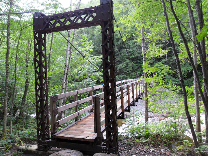
A bridge over the River Dry
Great swimming hole
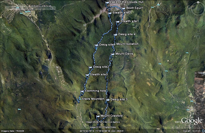
Tracks on Google Earth
Overall, this was a decent trip in fairly wet trail conditions. I got to finish sections of the Davis Path, as well as visit the Dry River Wilderness valley.
Stats: 25 miles, 6750 of ele gain, 16 1/2 hours over 2 days
Slideshow from this trip
Petch
Date: Tuesday/Wednesday, August 23/24, 2011
Peaks/Trails: Mt Crawford, Stairs Mtn, Mt Davis, Mt Isolation, Boott Spur, via Davis Path and spur trails, Camel Trail, Dry River Trail
Trail Conditions: Everything below tree line was wet, with the exception of the climb to Mt Crawford. Lots of blowdowns, climb overs, crawl unders on upper section of Dry River trail North of Shelter#3.
Cast of Characters: just me
Commentary
I had been planning another solo backpack trip this summer, and decided upon a semi remote area I've been meaning to check out. I've done parts of the Davis Path, and have been meaning to finish red lining it. The Dry River Trail had also sparked my interest. So, I put together a loop starting at the Davis Path, hiking all the way up to Boott Spur, up and over to Lakes of the Clouds, and taking the Dry River Trail back to rt302. It added up to be about a 25 mile hike, with an overnight at the Isolation tentsite.
So Tuesday morning, I drove up to Crawford Notch, locked my bike to a tree in the woods near the Dry River trailhead, and drove down to the Davis Path. I brought enough food for 3 days, and started with 5 liters of water- which was completely unnecessary. With about 32 lbs total pack weight, I began up the Davis Path at a very gentlemanly start time of 10:30am. The climb to Mt Crawford was putting the hurt on me. 2100ft of gain in 2.5 miles was a rough way to start, but the views were worth it. Whenever I do a backpack trip, I gain more and more respect for thru-hikers that get up and do this for months on end........physically, it's tough on the body.
Crawford Notch
Stairs Mtn
From there, I knew the hike over to Stairs was going to be a little wet, and it was. I decided to fore go Resolution (have been to it once), and continued on towards Stairs Mtn. The last time I was here, I do not believe this was a designated tentsite. But, with the Resolution shelter being closed, this makes the most sense I guess. There's room for 2 tents. Fyi- there's a Geocache on top of Stairs Mountain, as well.
Mt Resolution from Stairs Mtn
From Stairs to Mt Davis, the trail is very wet. More than once I plunged my trail runners into above the ankle deep mud. It was quite a slog. Somewhere in this section I dropped my sunglasses......so I doubled back and found them. An extra .5 miles added on, good times. As wet as things were, there were some very picturesque sections as well. The summits of Davis and Isolation are very similar, with 360 degree views.
After hitting both peaks, I stumbled down to the tentsite area just down the Iso East trail. I could smell a fire going, so I wasn't going to be so "Isolated". It's Tuesday night. That means 50cent wings! Why would anyone be out camping? Turns out there were a few tents jammed in the one area. I found a nearby spot and set up shop. I was beat, after being on the trail for 8 hours. Trail conditions were wet and slow going. I cleaned up, ate, hung my food bag, and was in the sleeping bag by 8:30pm. I put in the ear plugs which really helped in getting a good night sleep.
Next morning I got up around 6:30am or so. Bright sun filtered through the tree canopy. I put on some fresh socks and just slightly damp trail runners. The feet felt great. I made some coffee and oatmeal and picked up camp. l hung my wet socks on the outside of the pack to dry as I hiked. I filtered some water from near the trail as a back up, but I had carried enough to get me to the Lakes hut. I was looking forward to the climb up to Boott Spur. The Davis Path North of Iso East trail to the Glen Boulder trail was new to me. The climb went well, and getting above tree line was food for the soul. This is a great area to hike.
Davis Path between Boott Spur and Camel Trail
Then I descended down to Lakes of the Clouds Hut to refill on water, and see what was available for fresh "eats". Split pea soup? I was horrified, but the young lady assured me that it was real good. Two bowls later, I agreed. One of the hut crew walked in carrying a pack board with a total weight of 105lbs! I felt like such a Sally (no offense to anyone named Sally!) Imagine coming up the Ammo trail with that weight? Sweet Moses
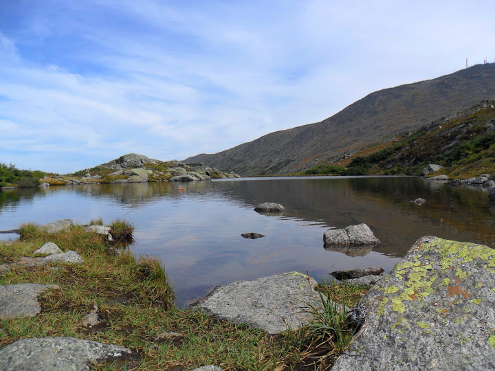
Lower Lake with Washington
Well, times a wasting, and I got a lot of miles to go. So, off again up to the top of Oaks Gulf. I was now on virgin trail for the rest of the hike, and was looking forward to exploring the Dry River Wilderness valley. The climb down into Oaks Gulf yielded fantastic views of the Southern Presi's and down into the valley. It was pretty wet, and at times the trail and run-off were the same. It was slippery and slow going as I entered the woods down below.
Top of Oaks Gulf
I really got the feeling like I was in the middle of nowhere. I don't think the upper section of the Dry River trail sees a lot of hikers. Very few footprints. The amount of blowdowns was impressive. It's kinda like Hurricane Irene already hit this place. Not just a tree here and there. There were sections where 3-6 trees had all fallen together. It was blowdown alley. Lots of crawl unders, and climb overs. Too many to count. The trail had a couple sections that were difficult to follow.
Yup, that's the trail, have fun in the land of blow downs!
If I were the trail maintainer, I would move to Florida...
I don't think I could hike more than 1mph until I hit Dry River Shelter #3. The shelter was in awesome shape. Tons of butterflies hanging around. It was still pretty wet on the next section down to the Mt Eisenhower trail/ Iso West trail. The final leg of the Dry River trail was a lot dryer and faster moving all the way back to rt302. About 1/2 from the trailhead, I found a nice swimming hole and the water was fantastic! Back at the trailhead, I unlocked my mountain bike, dumped my pack and took the 3mile bike ride back to the 4Runner. Then back up to pick up my pack.
A bridge over the River Dry
Great swimming hole
Tracks on Google Earth
Overall, this was a decent trip in fairly wet trail conditions. I got to finish sections of the Davis Path, as well as visit the Dry River Wilderness valley.
Stats: 25 miles, 6750 of ele gain, 16 1/2 hours over 2 days
Slideshow from this trip
Petch
")