
Scar Ridge. By reputation, one of the most-feared peaks on the New England Hundred Highest. Known for thick spruce, blowdown piles and a distinct lack of herd paths. In the past few years, a popular route has emerged which follows an out-of-bounds ski cut to Black Mountain, and bushwhacks southeast from the col up to the west end of Scar Ridge, and then due east to the western (and higher) bump, known as "West West Scar Ridge" (3774). The original AMC summit is on what has become known as "East West Scar Ridge", which is on more of a distinct point and thus easier to find. Near the summit of West West Scar Ridge, although it is mostly flat, there is a good herd path that leads past a rock with a mini cairn which appears to be the highest point around.
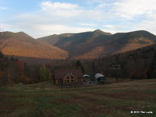
Camp III - Big Coolidge (L) and Whaleback (R) - 1500', Liberty and Flume peaking over the top - 2000'
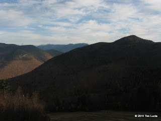
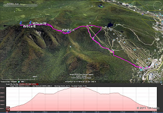
The route follows the maintenance road, known as the Brookway Trail, from the gondola, and up to Camp III (~1500'). From here, follow the Lower Walking Boss (blue square) and Upper Walking Boss (black diamond) to the summit chair. Be sure to turn around once in a while since the only real views from this route are from the ski trails. Of note on the two Walking Boss trails - there is a zig-zag water bar that runs back and forth across the fall line to reduce erosion from spring runoff. If the gradient is too steep, follow these - the footing is very firm and there is minimal plant growth. With the top of the lift in view, look to the left for two yellow out-of-bounds signs. A good herd path begins just uphill of the higher one. The four pictures above are taken at 1500, 2000, 2500 and 3000' respectively.
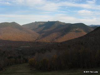
The Bonds appear above 2500'; All of Franconia Ridge at 3000'
Follow the herd path (back country ski access) for ~20 minutes / 0.6 miles to about 2850'. Here the herd path turns almost due north. The bushwhack begins here and follows roughly a southeast bearing, aiming for the western end of the highest part of the ridge itself. My timing this morning was perfect because the sun had just risen above the ridge and made for a perfect handrail. The woods were, much to my surprise and delight, much more open than I had heard. Also to my liking, the ground was pretty even and mostly firm, making it easy to cover ground without watching every step. There were some thick sections, and some blowdown sections, but probably 75% of the trip was easy going. As you approach the top, things flatten out considerably and a very clear herd path takes you to this baby cairn on a boulder. All in all, easier than expected. The 'hardest' thing today was that the spruce was wet, and so I was pretty soaked when I got here.
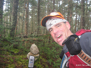
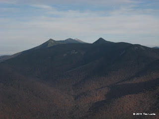
West West Scar Ridge, 3774', #85/100, Today's Route
When I started out, I had no idea how long it would take me, but having made very good time, I decided to venture over to the East Peak of West Scar, where the original AMC summit was. A pretty distinct herd path left the summit area of West Peak heading in the right direction. Just beyond the lowest point, there are a few thick sections, and one false summit. Being wet and cold, I took a picture and immediately retraced my steps. The herd path back to West Peak was right where I left it and before long I was heading back to the out-of-bounds ski / access trail. Now comes the trickier part of bushwhacking. On the way up, you can err on the side of going, well, up. The summit is a single point. Well, down is more interesting since you can go any which way, and the tendency is to be like water and follow the path of least resistance. Luckily, I had a GPS track to refer to if I got too far off course. I followed the same herd path down until it disappeared, although it would occasionally reappear. Or maybe it was a moose trail (I spotted a few very fresh piles of droppings.) My route down felt easier in terms of fewer obstacles, blowdowns and spruce, but it was not as straight a line either. Once back on the ski trail, I encountered three people who were "looking for the trail to Scar Ridge." I explained to them it was a pure bushwhack, with only faint herd paths, and they said they knew. They had walked back and forth 5 times trying to find where to start, so I gave them the waypoint where I started, and my entire collection of notes and maps, and my best recollection of bearings I had followed and wished them a safe and pleasant hike. Back at the ski area, I took Sunset and Haulback around the North Peak summit (both of these are blue squares) to avoid the really steep descent of Upper Walking Boss.
Round trip was 8.8 miles, ~3700 feet.
Tim
Camp III - Big Coolidge (L) and Whaleback (R) - 1500', Liberty and Flume peaking over the top - 2000'
The route follows the maintenance road, known as the Brookway Trail, from the gondola, and up to Camp III (~1500'). From here, follow the Lower Walking Boss (blue square) and Upper Walking Boss (black diamond) to the summit chair. Be sure to turn around once in a while since the only real views from this route are from the ski trails. Of note on the two Walking Boss trails - there is a zig-zag water bar that runs back and forth across the fall line to reduce erosion from spring runoff. If the gradient is too steep, follow these - the footing is very firm and there is minimal plant growth. With the top of the lift in view, look to the left for two yellow out-of-bounds signs. A good herd path begins just uphill of the higher one. The four pictures above are taken at 1500, 2000, 2500 and 3000' respectively.
The Bonds appear above 2500'; All of Franconia Ridge at 3000'
Follow the herd path (back country ski access) for ~20 minutes / 0.6 miles to about 2850'. Here the herd path turns almost due north. The bushwhack begins here and follows roughly a southeast bearing, aiming for the western end of the highest part of the ridge itself. My timing this morning was perfect because the sun had just risen above the ridge and made for a perfect handrail. The woods were, much to my surprise and delight, much more open than I had heard. Also to my liking, the ground was pretty even and mostly firm, making it easy to cover ground without watching every step. There were some thick sections, and some blowdown sections, but probably 75% of the trip was easy going. As you approach the top, things flatten out considerably and a very clear herd path takes you to this baby cairn on a boulder. All in all, easier than expected. The 'hardest' thing today was that the spruce was wet, and so I was pretty soaked when I got here.
West West Scar Ridge, 3774', #85/100, Today's Route
When I started out, I had no idea how long it would take me, but having made very good time, I decided to venture over to the East Peak of West Scar, where the original AMC summit was. A pretty distinct herd path left the summit area of West Peak heading in the right direction. Just beyond the lowest point, there are a few thick sections, and one false summit. Being wet and cold, I took a picture and immediately retraced my steps. The herd path back to West Peak was right where I left it and before long I was heading back to the out-of-bounds ski / access trail. Now comes the trickier part of bushwhacking. On the way up, you can err on the side of going, well, up. The summit is a single point. Well, down is more interesting since you can go any which way, and the tendency is to be like water and follow the path of least resistance. Luckily, I had a GPS track to refer to if I got too far off course. I followed the same herd path down until it disappeared, although it would occasionally reappear. Or maybe it was a moose trail (I spotted a few very fresh piles of droppings.) My route down felt easier in terms of fewer obstacles, blowdowns and spruce, but it was not as straight a line either. Once back on the ski trail, I encountered three people who were "looking for the trail to Scar Ridge." I explained to them it was a pure bushwhack, with only faint herd paths, and they said they knew. They had walked back and forth 5 times trying to find where to start, so I gave them the waypoint where I started, and my entire collection of notes and maps, and my best recollection of bearings I had followed and wished them a safe and pleasant hike. Back at the ski area, I took Sunset and Haulback around the North Peak summit (both of these are blue squares) to avoid the really steep descent of Upper Walking Boss.
Round trip was 8.8 miles, ~3700 feet.
Tim
Last edited: