BIGEarl
Well-known member
December 30, 2011: Isolation
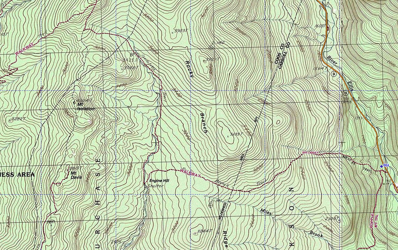
Trails: Rock Branch Trail, Engine Hill Bushwhack, Isolation Trail, Davis Path, Isolation Spur
Summits: Isolation
Hikers: Marty, Clarke, Dave, JustJoe, Kris, Ray, Rolly, Freddie, Trail Trotter (Sue) and me
If heaven holds a special place for bushwhackers, I’m sure it looks like a piece of New Hampshire found on the way to Isolation.
Our group on this hike to Isolation was a good one. It was a mix of old friends and new. Ray (aka Jazzbo) is well known to the local hiker community but we have never had the opportunity to hike with him. Hopefully we'll enjoy more trail miles together. Kris was a first-time hiker with us and hopefully he comes back for more. All of the others we have hiked with previously and it was good to see each of them again.
We had a plan to do a simple round-trip hike to Isolation from the Rocky Branch trailhead on Route 16 south of PNVC. When Sue and I pulled into the trailhead lot we found Marty, Clarke, and Ray already there and patiently waiting for the rest to arrive. Over the next half-hour the rest of the group arrived with several having been delayed by a detour caused by accident clean-up on Route 16. Roughly twenty minutes later than planned we were hiking.
Rocky Branch Trail was tracked out and frozen. There was a significant covering of ice and gradually, each of us pulled out the light traction to secure our footing. The climb to the height of land between Engine Hill and the south end of Rocky Branch Ridge went quickly. Along the way (~2.8 miles) we all spent some time visiting with each other, enjoying the morning, and gaining a little under 2000 feet in elevation. The climb is never really steep but it’s generally constant. The route passes through a beautiful hardwood forest with really nice mid-range views along the way. It’s a very good way to stay warm on a cold winter morning.
As we approached the height of land, the terrain flattened out, we wandered into some sections of conifers, and finally toward the west side we started into areas that are often very wet and muddy. In this area we could look to the northeast and see the south end of Rocky Branch Ridge. It was time to leave the trail and do some bushwhacking.
This bushwhack is a popular approach to Isolation since it eliminates difficult crossings of the Rocky Branch of the Saco River plus a lot of mud pits. Even though it’s called the Engine Hill Bushwhack it never actually spends any time on Engine Hill, which is located to the south. And, like other bushwhacks, there are no blazes or cairns to identify the route. Our approach to the “Engine Hill Bushwhack” involved contouring the west slope of Rocky Branch Ridge; we would not hike a trail or even a direction, we planned to hike a contour and allow the terrain to return us to the trail in the general vicinity of the final crossing.
We were all spread out on the trail when the decision to bushwhack was made. After a quick check we found Freddie (previously last in line) to be closest to an ideal location to head into the thick conifers that we needed to work through. Suddenly Freddie was leading the group. The simple objective; climb Rocky Branch Ridge to an elevation of ~3400 feet. Between the trail and the target elevation is some thick growth but after clearing a small flat section the climb happened fast. At ~3300 feet we stepped into the target area. Welcome to Bushwhacker’s Heaven! There is a huge open birch glade that follows the ridge and much of the bushwhack route. It’s open, clear of brush, there are terrific views to Montalban Ridge to the west and our target for the day, and it’s generally dry and free of mud. The price of admission is a short trip through some thick growth; but that’s a small price to pay for this treat.
Joe and Dave jumped out in front and headed up the ridge. We were still working a little below the target elevation of 3400 feet and gradually gained the additional elevation by favoring the upper part of the glade. I was periodically checking our elevation with my Thommen altimeter and actually saw we hit 3500 feet. We were walking in ~8 inches of snow. It was easy walking and there were many photo stops along the way. Ten pairs of boots beat down a route out and back that should remain easy to find and follow at least until we receive a significant snowfall. As expected the terrain led us back to the upper part of the Rocky Branch and the actual trail. I believe the bushwhack at 3400 feet saves roughly 1.5 miles each way over taking the established trail. At the end of the bushwhack we entered an area of moderately thick conifers. We were close enough to the Rocky Branch to hear it and simply headed down to the stream and the trail. In my view, we just enjoyed the high point of the day. In roughly 1.5 miles we would find the high point for the hike; Mt. Isolation.
From the end of our bushwhack route to the trail junction with Davis Path is an easy walk. Before long we were standing at the trail junction, having refreshment, and regrouping before the final ~1.1 miles to the summit. Back together as a group with all members accounted for we set off on the final climb. Most of the final approach on Davis Path is a mild walk with only the last quarter mile having a significant amount of elevation. As we had been doing since leaving the trailhead the group got a little spread out but that’s expected; everybody has a different ideal speed but we regularly stopped to regroup and make sure there were no problems. The next regroup point was the summit.
Gradually, everybody arrived at the summit. Out came the cameras for the usual summit pictures. The overall weather conditions prevented any enjoyment of the terrific views that can be had from the summit. After quick refreshment and to stay warm we were soon on our exit hike.
The plan was to simply re-trace our steps. That means another trip through Bushwhacker Heaven on Rocky Branch Ridge. First we regrouped at the Isolation – Davis Path trail junction, then again at the upper crossing, and finally we were leaving the trail headed into the conifers, and finally the birch glade. As we hiked the reverse bushwhack we stopped a couple more times to regroup. On one occasion Ray was approaching the group and carrying a very nice moose shed. He had half a pair of antlers in his hands. It was in beautiful shape. Soon it was lashed to his pack and we were all again making our exit.
Soon we hit the trail and took off for the trailhead. The only effort at this point was to beat darkness. We were hiking late in the afternoon and the overcast was already reducing the level of daylight. Roughly ½ mile from the trailhead we pulled out the headlights. Our hike to Isolation finished under the lights. What a terrific hike it was.
Thanks to everybody for joining the trek and adding to the day. I hope to see all of you again sometime soon.
I’ve posted some pictures from the day.
BIGEarl's Pictures
Straight to the slideshow
Last edited: