
Jimmy Legs and Little D
New member
We had heard many good things about the Ossipees and here was our opportunity to give them a try since we were using Brisol, NH as our base for the last two days of our winter vacation.
After a fantastic breakfast at the Henry Whipple House (B & B), we were ready to go.

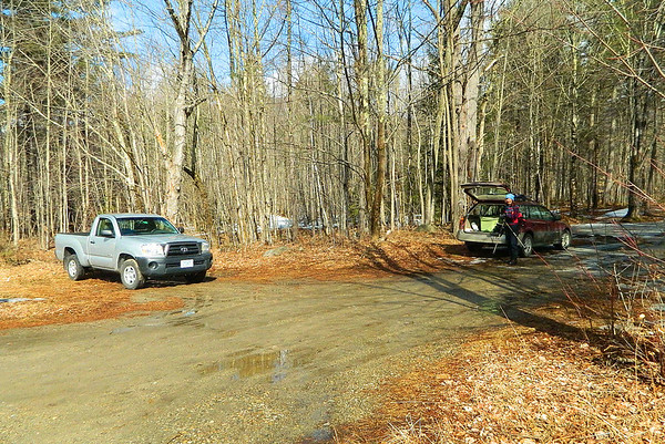
The trailhead was pretty easy to located on route 117 near Sodom Road. One other car was on the lot.
There wasn't much snow at the lot but the trail was icy so on came the microspikes.
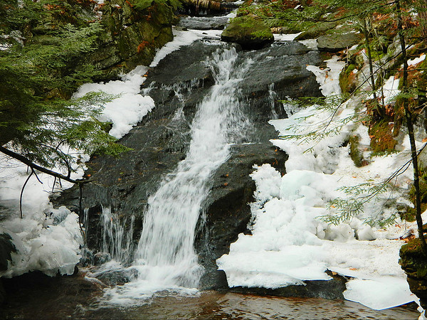
The lower section of the Mount Shaw trail is for the most part unmarked except for some red blazes and follows a logging road which parallels Fields Brook. About a quarter mile in there's a nice waterfall.
 .
.
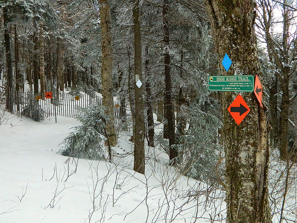
The trail narrowed and then once again became the logging road. Most of the lower sections of the trail were covered in ice. It wasn't until about a mile in that we began to have snow on the trail. Crossing Fields Brook for the last time the trail became much steeper until we reached the intersection with the Black Snout Trail. We turned right at this junction and then turned left in .23 miles. In .41 miles we reached the junction with the High Ridge Trail which is used by snowmobiles, but didn't appear to have been used recently. There is a snow fence on the Mount Shaw trail which prevents snowmobilers access to the section leading to Black Snout.
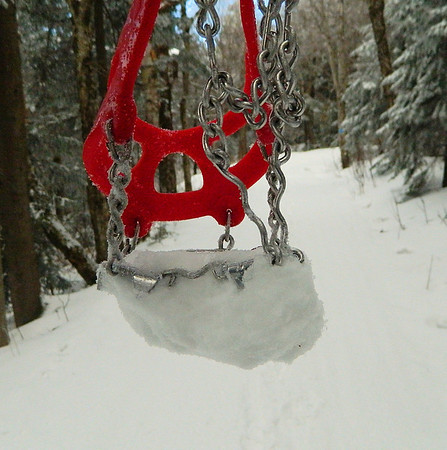
Just beyond this junction we noticed that our microspikes were "balling" up with snow. I decided to take mine off, while Donna forged ahead with snow clogging up her spikes
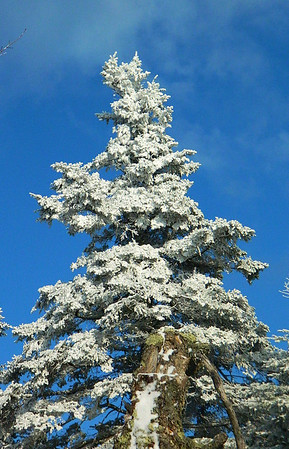
Nearing the summit of Mount Shaw the sky turn a brilliant blue and with the frosty white trees made for a great winter scene.
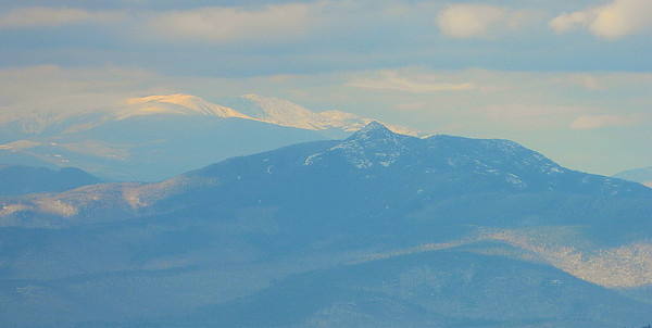
We reached the summit and were greeted with spectacular views towards Mount Washington off in the distance.
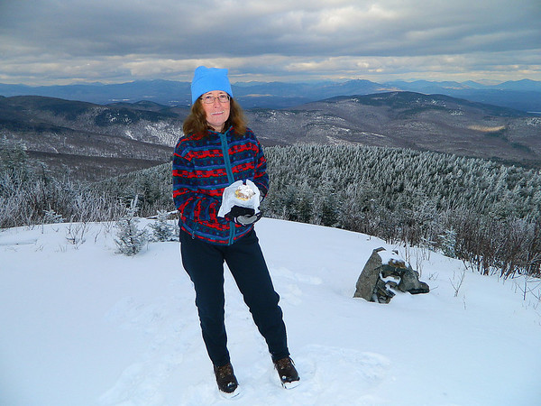
We were in awe as we snacked on crumb cake and took in the beautiful scenery.
After spending some time on the summit the wind chilled us and it was time to move on to Black Snout.
The walk over to Black Snout retraces the Mount Shaw Trail .7 miles and then another .2 to the summit.
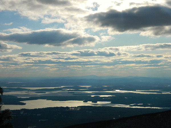
Views of Lake Winnepesaukee with the sun shining through the clouds was spectacular.
We throughly enjoyed our hike in the Ossipees and will surely return again in the fall.")
Here's the link to our slideshow of Mount Shaw and Black Snout.
http://jimmylegs.smugmug.com/Nature/Hiking/Mount-Shaw-and-Black-Snout/21621632_2BQ5TV
Mike and Donna (Jimmy Legs and Little d)
After a fantastic breakfast at the Henry Whipple House (B & B), we were ready to go.
The trailhead was pretty easy to located on route 117 near Sodom Road. One other car was on the lot.
There wasn't much snow at the lot but the trail was icy so on came the microspikes.
The lower section of the Mount Shaw trail is for the most part unmarked except for some red blazes and follows a logging road which parallels Fields Brook. About a quarter mile in there's a nice waterfall.
The trail narrowed and then once again became the logging road. Most of the lower sections of the trail were covered in ice. It wasn't until about a mile in that we began to have snow on the trail. Crossing Fields Brook for the last time the trail became much steeper until we reached the intersection with the Black Snout Trail. We turned right at this junction and then turned left in .23 miles. In .41 miles we reached the junction with the High Ridge Trail which is used by snowmobiles, but didn't appear to have been used recently. There is a snow fence on the Mount Shaw trail which prevents snowmobilers access to the section leading to Black Snout.
Just beyond this junction we noticed that our microspikes were "balling" up with snow. I decided to take mine off, while Donna forged ahead with snow clogging up her spikes
Nearing the summit of Mount Shaw the sky turn a brilliant blue and with the frosty white trees made for a great winter scene.
We reached the summit and were greeted with spectacular views towards Mount Washington off in the distance.
We were in awe as we snacked on crumb cake and took in the beautiful scenery.
After spending some time on the summit the wind chilled us and it was time to move on to Black Snout.
The walk over to Black Snout retraces the Mount Shaw Trail .7 miles and then another .2 to the summit.
Views of Lake Winnepesaukee with the sun shining through the clouds was spectacular.
We throughly enjoyed our hike in the Ossipees and will surely return again in the fall.
Here's the link to our slideshow of Mount Shaw and Black Snout.
http://jimmylegs.smugmug.com/Nature/Hiking/Mount-Shaw-and-Black-Snout/21621632_2BQ5TV
Mike and Donna (Jimmy Legs and Little d)