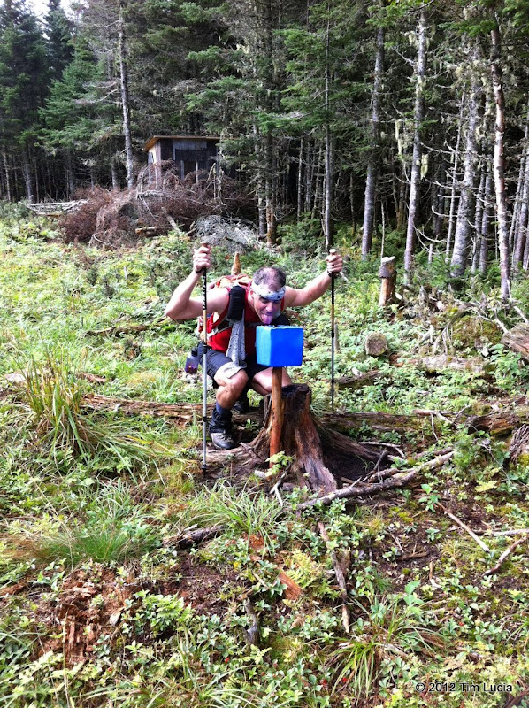
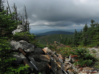
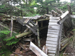
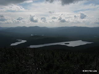
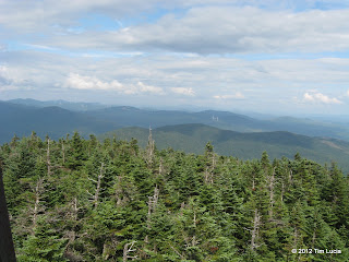
Maine NEHH Six Pack plus Elephant, 8/11/12 - 8/14/12

vftt.org

Help Support vftt.org:

This site may earn a commission from merchant affiliate links, including eBay, Amazon, and others.

bikehikeskifish

Well-known member
VFTT Supporter
Joined
Oct 4, 2006
Messages
6,096
Reaction score
541
Location
New Hampshire
Peaks

Elephant, White Cap, North Kennebago Divide, Snow (Cupsuptic/Little Kennebago), Boundary, Snow (Chain of Ponds), East Kennebago

Lodging

Stu and I stayed at the Spillover Motel in Stratton Maine. I stayed there in 2010 when I did the Rangely 4Ks, and was happy to return. They have much improved WiFi and a new gas grill, but otherwise it's the same old place. Ran into Ed Hawkins (Hiker Ed), Bob Martin (Wolfgang), Sandy Price (Sleeveless), and Dee Ressler. Had a PBR with Ed and Dee.

Food

Ate breakfast once at The Looney Moose (formerly Mainely Yours), and dinner once at Tufulios . Otherwise, we cooked/ate at the Spillover.

Driving

From my house near Manchester, NH, total driving was ~750 miles. From Stratton 16/27, this included ~75 miles for the Tim Pond, Bear Brook and Wiggle Brook loop and ~75 miles for Boundary and Chain of Ponds Snow.

Road Status

All roads are in good or better condition, and we made it to the generally-accepted end of each.

Elephant (3.3 miles) - Very good, no scrapes, tall grass in the middle of two gravel tracks (Honda Accord)
Tim Pond (17.4 miles) - Excellent, recently graded (Subaru Outback)
Lincoln Pond (3.4 miles) - Excellent, recently graded (Subaru)
Bear Brook (4.0 miles) - Excellent, recently graded (Subaru)
Wiggle Brook (4.6 miles) - Excellent, recently graded (Subaru)
Boundary (8.3 miles) - The loop was in very good shape, puddles and potholes, nothing too deep, however, the last mile to the gravel pit was in less good shape and the last .25 miles was sketchy and my Honda Accord touched bottom gently a few times, but made it without apparent damage to the gravel pit.
Chain of Ponds Snow / Round Mountain Pond Road (4.8 miles) - Excellent, recently graded (Honda)
East Kennebago (4.3 miles) - Excellent up to the first major fork (Seven Gulpers). Beyond this, there are ~20 drainage ditches across the road, which my Honda would definitely not like. The "Stubaru" made it with only a minor scrape of the muffler.
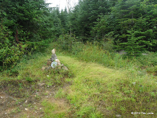
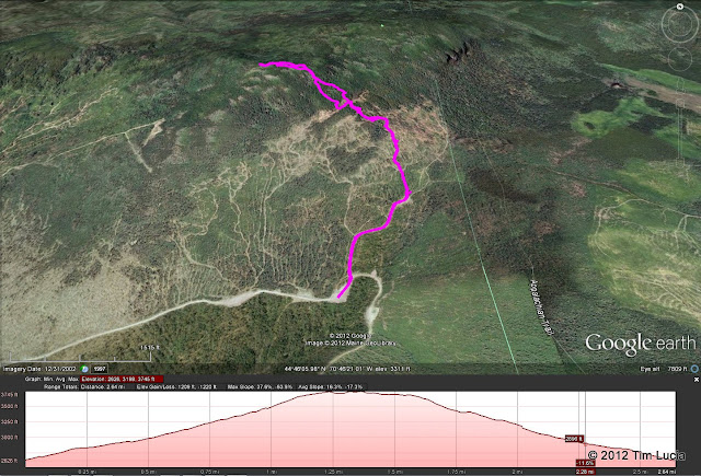
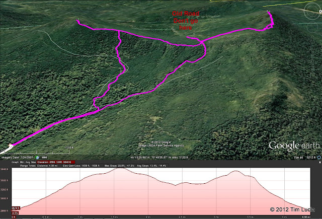
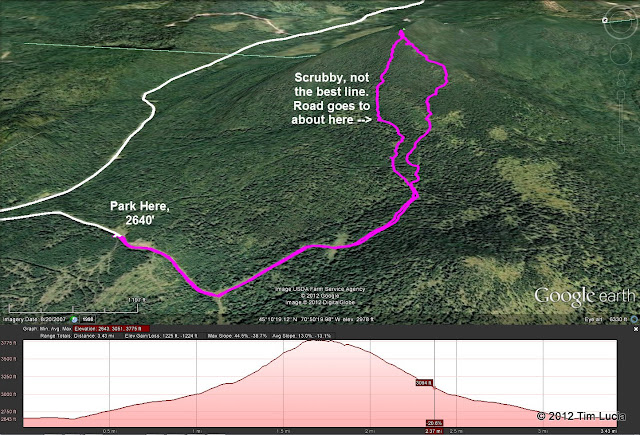
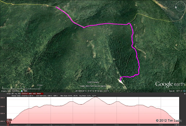
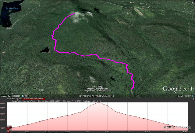
Map

 
Last edited:
Elephant

Day 1 - Elephant - 2.6 miles, 1220 feet, 2:15

On Saturday morning, I got up without the alarm, packed the perishables in my car, ate breakfast, and drove to Andover, ME (~180 miles) to tag Elephant. Made it all the way to the end of Elephant Mountain Road (2600') and found Bryan Cuddihee's vehicle parked there. I didn't know it was his until I got to the register, but I caught him before he left on the way out. Followed the road from where I parked up the hill to the split. Turned left here at the cairn, and followed that road until the next cairn (2900', 0.33 miles) where I left the road and began the bushwhack. There are two obvious ways to go at this point, and I chose left, more or less following an another road due north (magnetic).
IMG_0124.JPG
IMG_0127.JPG

Leaving the road to the left, heading due north (magnetic); Blue and red boundary markers

At about 3400', I came to the highest skid/haul road which runs along the contour and across my path. Where I came out there was a decent-sized split boulder which I remembered for the descent. I worked slightly left and uphill where I found the blue/red boundary markers. From there I followed some faint herd paths around the notorious blowdown patches and worked my way to the canister. On the way back down, I followed a more obvious herd path, but lost it for a while, pushing through some thick spruce for a bit, before picking it up again, where it went around the opposite side of the blowdown patches. I came out again on the road at 3400' and turned left until I found the rock, where I followed the same herd paths back down.
google%2520earth.jpg

Route to Elephant: white = driving, magenta = hiking

Drove to Stratton to the Spillover Motel and met Stu who'd brought some big old ribeye steaks for dinner.

Photos from Elephant
 
Last edited:
White Cap/North Kennebago Divide

Day 2a - White Cap/North Kennebago Divide - 4.5 miles, 1650 feet, 4:15

From Route 16 and 27, head west on 27 for 6.6 miles to the left turn for Tim Pond road (2.6 miles past Cathedral Pines Campground.) They are actively logging in this area now, so watch out for trucks! The plus is that the roads were all nicely graded, especially beyond the Kennebago River (Wiggle Brook Road.) We made it all the way to the end of Bear Brook (2670') and parked just to left of the road. We struck out for White Cap, following the most obvious logging road up to the col with North Kennebago Divide (3450'). Here you bear right (do not go straight - more on this later) and continue on to 3670' where there is a big cairn. Straight ahead (ENE) is a route which bears right and heads down parallel to the road we came up (it is directly behind Stu in the left picture below.) You could follow this road up and find the cairn from the other direction. To the left (NNW), is a herd path with a tiny cairn perched on a blowdown. The herd path takes you straight to the summit.
IMG_0148.JPG
IMG_0149.JPG

Stu at the big cairn, where the two roads join; The little cairn on the log marking the herd path to White Cap

After considering our choice between bushwhacking straight over, or returning to the col, we opted for the latter. There was a tempting right turn in the col in an open, ferny area, which was flagged (3450', blue tape) but appears to be the continuation of the road we followed up (see above, where you do not go straight). This could be a snowmobile trail, but it heads down and away from North Kennebago Divide. We returned to the col, and took a bearing to the peak, and followed the ridge line through fairly open woods until we found a herd path which took us to the summit. From the summit, there is a herd path which continues southward and appears to connect to an old road. We went back the way we came, and at 3580' (a bit of a view here) bushwhacked straight down the fall line (this was steep and mossy with some blowdowns, but was not thick, until we hit the woods road (3200', I suspect this joins with the south-bound herd path from the summit). From here, we chose a bearing which looked to be the third side of a triangle with the road that descends back to the car. This worked out perfectly and we were treated to a very open woods road with tons and tons of pearly everlasting and (much less) hawkweed. Eventually, this merges back with the main road and back to the car.
IMG_0162.JPG

Nice woods road with abundant wildflowers

WC-NKD-GE.jpg

Route to White Cap / North Kennebago Divide: white = driving, magenta = hiking

Photos from White Cap, North Kennebago Divide and Cupsuptic Snow
 
Last edited:
Cupsuptic (Little Kennebago) Snow

Day 2b - Cupsuptic (Little Kennebago) Snow - 3.5 miles, 1225 feet, 2:45

We next drove back down to Wiggle Brook Road. On the way, we debated the "straight up the fall line" versus "come in from the logging landing" route. The latter, it is claimed (by the FTFC) doesn't save much. The road to the landing was very nicely graded and got us a much better start, at an elevation of 2660'. Again, follow the road, turning left and up hill when it opens up (2675', do not continue onward as it heads down hill.) After 0.6 miles you come to another landing area (2825'), with a cairn, and an arrow made out of wood. The road continues to 2925' after which there appear to be many possible routes along former roads. We opted to follow one a bit to the left, which eventually angled down hill. From here we took a bearing to the summit and bushwhacked to the ridge. This route was not ideal, but we were able to find a way through most of the blowdowns. It was a fun navigational challenge. Once on the ridge, a herd path took us straight to the canister.
IMG_0166.JPG
IMG_0180.JPG

Navigational aide; Moose skull

On the way down, we followed the obvious herd path, which passes by the moose remains (only fur) and a skull on a stick. We lost the path in a few places, but kept on a bearing for the landing area and picked up numerous old roads until we were back at the cairn and arrow. I would recommend opting to go more to the right (bearing due east) above the landing in hopes of picking up that herd path rather than to the left.
CUP-GE.jpg

Route to Cupsuptic Snow: white = driving, magenta = hiking

Went to Tufulios and had the 2-for-$24 special - veal parmesan for each of us. With a salad and calamari appetizer, it was a very good meal for the money, and one of the few places open on a Sunday evening.

Photos from White Cap, North Kennebago Divide and Cupsuptic Snow
 
Last edited:
Boundary Peak

Day 3a - Boundary Peak - 4.0 miles, 1280 feet, 2:25

Headed north on 27 for about 30 miles to the Canadian border. Gave our passports to the Candian customs person, she asked if we were US citizens and where we were going (told her Boundary Peak) and how long we were staying. Ran our passports inside and came back out and said "have a nice time". Coming back, the US customs person was a bit more thorough. It takes about 3-4 times as long to come back, based on about 4 cars going north for every one going south. Some cars were searched, although we were not. A few questions about where we were born, where we were from, where we were staying, how we'd met, etc. Driving wise, the last mile to the gravel pit was the only sketchy part, and only the last .25 miles of that last mile were really sketchy, but my Honda Accord made it with a few minor scrapes. Starting elevation was nearly 3000'.
IMG_0193.JPG
IMG_0214.JPG

View to Boundary Peak from the border swath; View from Boundary Peak to the west

We headed towards the ATV trail at the back right corner of the gravel pit, took the right branch, crossed the stream (tiny brook trout were seen here), and headed up the ATV trail. The first 15 minutes or so are steep and a bit loose. 30 minutes after departing, we came to the border swath. Both sides of the ATV trail are signed and flagged, and clear as day the gravel continues to the north towards Boundary Peak. Cannot possibly miss this turn on the way back. We descend for a bit past some hunting blinds and several salt licks and water barrels. At one point, we spooked a whitetail (ran to the US woods). The path is wide, and well-traveled all the way to Boundary Peak where there is a large cairn. The canister is slightly into the woods behind the cairn on the US side.
Boundary-GE.jpg

Route to Boundary Peak: white = driving, magenta = hiking

Photos from Boundary Peak and Chain of Ponds Snow
 
Last edited:
Chain of Ponds Snow

Day 3b - Chain of Ponds Snow - 6.8 miles, 2200 feet, 3:45

We were once again greeted by pretty newly graded roads, and a few logging trucks and slash piles / other signs of logging (clue #1). We parked next to one car, having seen another leave while we were coming in. Besides meeting Bryan at Elephant, this was the only other hike where we saw anyone, and they had apparently been only to the pond. We spent the afternoon following a series of wide, rocky and sometimes muddy ATV trails. Right out of the parking lot, there is a brand new bridge, put in by a crane, based on the size and width of the tracks. This is not a hiker's bridge. It's not really an ATV bridge. This bridge will carry heavy equipment (clue #2). There is a sign on the way that says "Snow Mountain Trail" and points right. We followed this to a muddy area where there are three trails/ATV roads. The right one and the middle one join about 50 feet later, and the middle one avoids the mud on the right one, so this is the one you want (there was a sign on the ground pointing left). Another stretch of moderate climbing brings us to 2.5 miles and 2950' where some flagging and a cairn indicate the height of land and a right turn onto the trail to the summit.
IMG_0218.JPG
IMG_0223.JPG

Cairn marking the "trail" portion of the hike; Telephone wire on an old pole

This trail is not that well maintained, but it has more of a White Mountain feel to it than anything else we hiked. It is steeper and rockier than the other peaks from this trip, and includes an interesting scramble. There are a few viewpoints along the trail where we stopped for a drink and to catch our breath. Just before the top is a wooden register, adjacent to the remains of the cabin. The tower on the summit is just beyond and while the cab is lying in a heap to the side, the tower structure and ladder easily held both of us. With the tower, the views are 360, and you can see the Kibbe Wind Farm and transmission lines across the road (clue #3).
IMG_0227.JPG
IMG_0229.JPG

Remains of fire warden's cabin; Big Island Pond from the tower
IMG_0237.JPG
IMG_0233.JPG

Stu by the cabin remains; Kibbe Wind Farm

When we returned to the car, we met a retired hippie and his German short haired pointer. After making peace with the dog, he told us some stories about hunting and how things had changed. He mentioned increased logging, and the proximity to the existing wind farm (Kibbe) and transmission lines, and a fellow he had met with a fancy radar to track and count bats. It was his opinion that there was a movement under way to put more wind turbines on the Penobscott property. It became obvious after a while that this guy could talk forever, and we were tired and hungry, so we excused ourselves. Well, not 2 minutes out of the parking lot and a white van with orange flashers and a Furuno radar array on the roof comes by, towing an ATV. Shortly thereafter, another pickup (also white) comes along. We concluded, in fine conspiracy theory form, that the hippie dude was waiting for these guys, and feeling us hikers out for our feelings on the matter.
COP-GE.jpg

Route to Chain of Ponds Snow: white = driving, magenta = hiking

Clue #4 - when we got back to the motel, there were 3-4 3/4 ton pickups with ATVs in the back. They were from Alabama, 25 hours away, and were "counting trees" for "management" purposes. They claimed, when asked, that they work on piecework and would be able to complete their job for less money and in 1 week versus 3 weeks for local salaried persons. They also mentioned that "walking on trails must be nice, as we are walking straight north-south lines on the mountain" (but did not say which.)

Photos from Boundary Peak and Chain of Ponds Snow
 
Last edited:
Day 4 - East Kennebago - 3.0 miles, 1280 feet, 2:25

From Route 16 and 27, headed south on 16 for 9.1 miles to the unmarked right turn for Langtown Mill Road. It immediately T-bones, and the right branch crosses a stream, which should help ensure that one is in the correct place. We left my Honda at the branch for the "Seven Gulpers" camp, where the left branch is marked "Private". Drove Stu's Subaru up to the 2660' landing, managing to cross approximately 20 drainage ditches in the process. The first half dozen or so should be doable in most vehicles, and there is a landing / parking area off the road before the next batch. I got out of the car for several of them, but remained in the car for the descent as we had found a route through each. A low-clearance vehicle will have trouble and you may be forced to walk for 2 additional miles each way. Since a Jeep would clearly make it, you could probably remain within the AMC rules and use a mountain bike. Descending through the ditches would be a lot of fun!
IMG_0247.JPG
IMG_0250.JPG

Cairns at the boundary at 2950'; Tim and Stu on East Kennebago

Once at the landing, continue straight on the main road, crossing through even bigger drainage ditches, which eventually would require an ATV to cross, until you are on a grassy woods road lined with hemlocks on either side. After 0.9 miles, you will come to a yellow stake (2950') on the right side and a few cairns to the left (one of which is blazed yellow.) From here, follow the boundary cut (faint blue/yellow blazes) on about a 270 degree (magnetic) bearing to about 3200'. There are a few spots with blowdowns, but there were herd paths around them. There was a cairn just before the height of land on the boundary cut, and there are two herd paths here, one to the left, and the other to the right of a blowdown area. We went up the left side and came down the right. I think the left was easier (there were several small cairns along the way.) Neither one was difficult to follow and in fact you can do this hike in shorts and a tank-top and except for blowdowns, never touch a tree. The summit is approximately on a 360 degree (magnetic) bearing from the cairn at 3200'.
GE.jpg

Route to East Kennebago: white = driving, magenta = hiking

This was the easiest of the "trailless" peaks by far. Didn't need the map or compass at all.

Photos from East Kennebago
 
Last edited:
The above seven peaks put me at 94 of 100 for the NEHH. I need all six peaks in Baxter State Park to finish. Special thanks to Bob & Geri, whose web site is still very accurate and relevant, and to Timmus for her beta from last fall, and to Damselfly (Beth) for her beta from last month. Thanks very much to Stu for the company and sharing the driving.

Tim
 
Nice TRs and nice work getting the peaks!

I'd guess The Rack, a 1/4 mile up the Sugarloaf access road, was probably open, too.

Note that normally it is not wise to say to the border agents that you're going to hike Boundary or be in the swath. Future hikers and readers here, just say you're going to hike Gosford. In fact, if you have time, do hike Gosford, too!
 
The Spillover desk clerk (Karen) mentioned some place at Sugarloaf that would be open, but I don't believe it was The Rack. Also, I had heard the same thing as you about telling the border agents about Gosford versus Boundary and I wanted to test it out. Neither one batted an eye. It seemed obvious to me that they hear this rather frequently.

Tim
 
Awesome trip report Tim - it's great reference material!! I bet it took you as long to put the report together as it did for you to hike many of the peaks :)
 
Nice TR. That will be a great reference for anyone going for those peaks. Sounds like you had a fun time.
 
Wow, that sounds like a colorful trip. Sounds like trying to get back into NH was interesting with all the questions. No offense Tim but you looked a bit bonked out on some of those self-portraits! Looks like a unique area and beautiful views and a whole lot of work! Congratulations!! Sounds like your not far off from reaching your goal!:D
 
Thanks

Hey Tim, been out of the loop for a few days. After reading your tremendous trip report there is no need to add much! I did want to say thanks to Bob&Gerri, Beth, Jeremy and Marc Howes as well as many others. It was also great talking to everybody at the motel. We had a great time driving the back roads which are actually in great shape right now. The actual hikes were fairly easy after doing all the research...but I still would not want to get turned around in there. We had good weather for the most part, good food and good hiking. A real nice vacation. Tim, make sure you post that picture of the buck at the salt-lick, it's priceless....Cheers and thanks for the hike! Stu
 
Top