General Trail Building Question

vftt.org

Help Support vftt.org:

This site may earn a commission from merchant affiliate links, including eBay, Amazon, and others.

Jeff&Henry

New member
Joined
Mar 4, 2012
Messages
39
Reaction score
1
Location
Norwell, MA
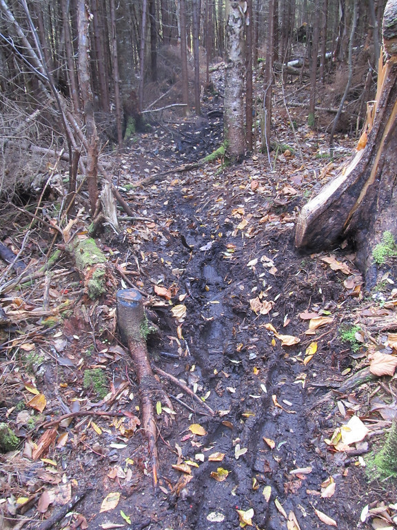
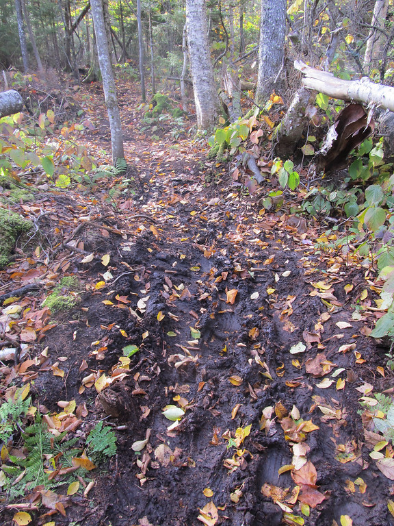
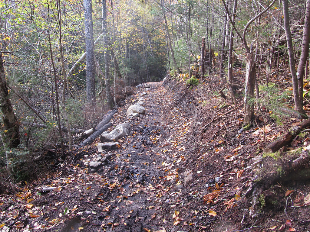
I'm curious -- is their a new preference that new trails are "trenched" rather than flush with the ground? Post Irene, it would appear that most of the new trails I've encountered (such as the new section of Gale River, the lower section of Signal Ridge, the re-route of Gorge Brook on Moosilauke, etc) are significantly below the grade, and I'm wondering if there's prevailing wisdom for the method...

I'm not criticizing in anyway, just trying to understand. Personally, last week on the re-routed section of Gorge Brook, it felt a bit more like a Tough Mudder course, then a trail... ;-)

I also have an ulterior motive for asking -- my town has recently stated they'll be building a trail system throughout and I'd love to help out. I think I know what makes a good trail, but recognize I can always learn more. If anyone has any favorite trail-building books, please pass the names along.

Many thanks.

JW
 
Not at all really. In my experience, the method differs quite a bit depending on the location and resources available (and laws). But most of the time the trail should be even or slightly raised above the surrounding terrain to shed water away. Trenches become streams in a rainstorm. I can't speak on the Gorge Brook relo, but if you are near the Falling Waters trail any time in the near future check out the relocation of the first .2 of the OBP and compare it to the washed out trail which is located about 10 feet to the side.

As for the Gale River trail. I believe the trenching you are referring to is actually "duffing" where you remove the organic (non-mineral) soil. A lot of that relocation runs through some thick pine which would have quite a duff bed to be removed. If I recall it's not an exceptionally wet area so raising the bed or installing drainage doesn't seem to be a concern in that area. I'm sure as the trail gets used and the ground packed that will change.

I just pulled out my AMC Trail Building and Maintenance guide and they specifically mention duffing on a flat trail will cause trenching which will collect water (4th ed. p118). It is also mentioned that a common technique is to dig a pit nearby for mineral soil to use on the treadway. I highly recommend the AMC Guide.
 
Last edited:
I cannot conceive of trenching as a suitable treadway for any trail, anywhere, unless it were a flat area and the trench was designed for drainage of the general area ... in which case the trench/treadway should contain stepping stones. Trenches foster erosion of the trail and standing water will lead to hikers skirting the edge of the treadway causing a widening of the path and, eventually, further erosion.

My 2nd edition of Appalachian Trail Design Construction and Maintenance refers to "trenches" as ditches, designed for drainage, not treadway.

I have not been on the trail initially mentioned but have seen treadways below the surrounding grade, usually the result of duff removal and erosion but not by design. Proper construction in such an instance, IMNSHO, would be to dig an adjacent drainage ditch and use the gravel removed (but not the organic soil) to build up the treadway.

Thanks for the detail Stan. Here's a photo of the trail that prompted my question: http://jcwheel.smugmug.com/Hikes/misc/25991686_zbThFG#!i=2156842983&k=tLWXjsH&lb=1&s=A.

Now, after a good 1/4 mile of trudging through this mud (and trying NOT to walk the margins thus making the trail even wider) I was puzzled as to approach.

I look forward to picking up your book, and joining one of the AMC crews; I'm convinced there's alot of learn.

JW
 
The photo looks like a drainage ditch rather than a trail. Not sure what they were thinking. Ditching along a trail is very common, but you still need to have a trail higher than the ditch.
 
I agree, Peter.

(I'm still sorta stunned by how many people have a copy of trail building and maintenance books...)
 
Yeah, I agree- that is without a doubt improper trail conscription.

Ideally, a trail will look pretty similar to a road. It will be slightly "rainbow-shaped" in cross section, which facilitates drainage. Certainly, you'd want the trail to be above the grade, or at least have a drainage ditch along side it. Many trail "improvements" are designed to get water off of the trail as fast as possible.
 
JW, I've recently had thoughts similar to yours --- specifically on the newly relocated Gorge Brook section. I spent a lot of time, after wading through or trying to avoid that section, contemplating the situation. My amateur conclusion, based only on "a few years in the woods," is that ----- isn't this the way new trails evolve? The older, more mature trails we hike have gravel, rock or ledge bases --- solid stuff. They too must have had wood duff, organic surfaces in the beginning. The constantly churned organic soup on top had to have eroded away over time --- down to the mineral matter. None of us want to believe that we contribute to soil erosion ------ but, don't we?
Remedies? Probably none are perfect, but a few thoughts: Trail location on the least deep organic soils where possible, strategically placed bog bridges and stepping stones, water bars with settling areas off trial for sediments to hold in rather than flush immediately to running water ---- and, winter hiking!
This is a serious issue that we, as a responsible user group, should fully address. Thanks for raising it.

The best way to combat erosion is to carefully plan the trail out before it's constructed. Ideally, hiking trails will remain below 10% grade. For steeper slopes, you'd use switchbacks to maintain the grade to that standard.

Our trails here in the east were largely cut before anyone knew anything about proper trail design and maintenance- that's why they are all so steep. In contrast, most trails out west were built later, when knowledge about proper trail construction had been gained by the recreation management community. That's why you typically see switchbacks more frequently out west than on the east coast.

As funding and manpower permits, some of our trails in the northeast are being re-routed, with switchbacks replacing the steep ascents.
 
I look forward to picking up your book, and joining one of the AMC crews; I'm convinced there's alot of learn.JW

Just to clarify the matter, I only own the book, I didn't write it. I'm pretty certain it is an older edition but it contains good information and I'd be happy to send it to any aspiring trail builder/maintainer.
 
Last edited:
The best way to combat erosion is to carefully plan the trail out before it's constructed. Ideally, hiking trails will remain below 10% grade. For steeper slopes, you'd use switchbacks to maintain the grade to that standard.
Really? Below 10% I do inspections for public works projects and most new road specifications here in NH are max 8%. Hiking trails that are not much steeper than roads dont sound very fun.
 
Really? Below 10% I do inspections for public works projects and most new road specifications here in NH are max 8%. Hiking trails that are not much steeper than roads don't sound very fun.

I agree. The equals one foot up for every 10 feet out. I consider that the flat trail that leads to the base of the mountain. That would make for some very long switchbacks.
 
Really? Below 10% I do inspections for public works projects and most new road specifications here in NH are max 8%. Hiking trails that are not much steeper than roads dont sound very fun.

Yes. Standards for hiking trails aren't that much different than standards for roads. Like I stated above, the ideal hiking trail is going to have a lot in common with a well-constructed road.

Erosion and gullying are going to be major issues over time if a trail exceeds 10% slope without some significant improvements. Steeper trails require a lot more annual work to maintain (even simple improvements like waterbars typically need annual maintenance). 20% is generally considered the absolute maximum, and above this usually necessitates major improvements. 10 and 20% may not seem like much, but in reality, even the steepest trails in the northeast are only about 30% grade (human tendency is to overestimate steepness).

In the Adirondacks, I've seen trails with a grade of only 10 or 12% that had been neglected for years- and consequently, the gullying was 2 feet deep in spots. Studies in the Adirondack High Peaks have also shown that trails at higher elevations in the mountains often lose about an inch of soil every year (erosion is exacerbated in the mountains due to greater amounts of rainfall at higher elevations).

I've seen posts here (and in other online northeast hiking communities) that indicate resistance to the idea of favoring gentler grades over steeper ones for our hiking trails. Certainly, visitor perception of a hiking trail is a valid aspect of trail construction and maintenance, and there is value to routing a trail in such a way so as to increase its difficulty and provide for a more rugged experience. Among the general hiking public, our northeast trails have a great reputation for being steep and challenging, but in the recreation management and trail building community, our trails are well known for being in horrendous shape. In taking pride in our steep trails (as we so often do), we need to realize that there are significant ecological ramifications to steep trails, and also understand that these are the trails that require to most time and money to maintain.

I would strongly encourage everyone who hikes regularly on steep trails in the backcountry to get involved in volunteer trail work. Even just a day or two every year of helping out can make a huge difference in limiting our impacts on steep trails. :)
 
All good info. The other thing that can be done, and has been on many trails, is to take advantage of small slides, outcrops, etc. of solid rock to gain height quickly (trails on the Great Range in the Adirondacks show many examples of this). So the trail might plod along at 10% while it's on the soft soil, but then become nice and steep, gaining height efficiently, when there are available rock outcrops to use. As DS pointed out, this takes advanced planning; really understanding the terrain before selecting the trail route. I don't always see that, even on brand new trail routes.
 
As TCD points out, stable trails can exceed 10% average grade if they incorporate steps to attain the additional elevation gain. The key is to get the "ramped" sections between the steps down to a stable grade (under 10%), with the steps pushing the overall average grade much higher (e.g. 20%).
 
I'm glad someone else noticed this about the new section Gale River Trail. We happened to travel the new Gale River Trail (in 2011) right after it opened and we thought it was marvelous to travel. Later in October of that year I had occasion to travel that section again. I was surprised to see how the trail had devolved into a long black mucky trench. The leaf layer had been compacted down to a trench that acts to collect water and hold it due to organics in top soil.

I think this is due to trail being routed across a relatively flat terrain. My first response is always where can we install waterbars? but due to level terrain there is no where to drain the water to. It might have been better to route the trail closer to edge of the stream terrace to provide down slope to drain to.

As others have noted the top soil layer is deep organic and holds the water. Just 8-10 inches below is sand and gravel. Someone suggested mining gravel from neighboring area and fill trench with mineral soil. I'm sure there is plenty of mineral soil in area available for mining. Look under uplifted roots of any spruce blown down and you can find all the sand & gravel you want. Mobilize 3-4 people with shovels and 5-gallon buckets and you're in business.

The entire trail not mucky, but there are long stretches that are mucky. Someone needs to evaluate labor to back fill versus labor to re-locate closer to edge of terrace to permit run-off to lower elevations. Might be a good experiment to fill in stretch of muck and see what happens over time. I'm sure the Hut Croo doesn't appreciate lugging heavy loads to supply the hut via this mucky trail.

IMG3756-XL.jpg


IMG3755-XL.jpg


The organic muck will not go away with time. it either has to be removed or trail re-routed closer to edge of terrace. The following photos show new section of Gale River Trail that descends to Hawthorne Brook and passes along edge of the terrace. Note the relatively stable drainable sand and gravel on the treadway and cut-bank.

IMG3757-XL.jpg
 
Last edited:
The organic muck will not go away with time.

Yeah, once you get a good organic mud in your tread, it's going to be there for the duration. This is the problem with corduroy (laying logs across the trail)- it eventually rots and makes things even worse in the long run. In some spots, we're still dealing with the effects of this on trails that decades ago were logging roads with a corduroy surface.
 
drainage, drainage, and drainage (adapted from the realtor's criteria for valuing land by its location)

Jazzbo mentioned this Gale river problem to me last Fall. Now we have a year's impacts plus good photos showing the alternatives.
To keep the trail on its present route over the mucky flat and make it resistant to traffic/widening means turnpike, stepstones, or bog bridges. For the length of the muck. All very labor-intensive/expensive to build, and bridges need replacing in 10-15 years, and the turnpike needs new gravel/recrowning every so often.
To move close to the edge of a bank for better drainage on mineral soil with a little sidehilling (maybe less than is pictured) is usually less construction time/foot, then far less upkeep/replacement time in the future.
These choices are discussed in all the trail manuals I own (AMC, ATC, SCA, BTCV USFS), and they all prefer sidehilling.
In fairness to whoever decided on the present route, one factor they may have had to consider, but has not been mentioned here, is the chance that a trail close to the edge of the bank may be at such risk of being undermined by the river below that they decided to keep it well back from the bank. If so, the next question is how soon do they hope to add the hardeners mentioned above to deal with a trail on land so flat it is almost undrainable?
 
(Old trail is completely washed out on the left, new trail is elevated on the right)
http://amc-nh.org/committee/trailcr...After Repairs_unknown_20120716_OBP_After2.jpg
I'm sorry, but I don't see this as a good example

If you look carefully, the new path already has a visible trench which will only get worse with more traffic, and the stones placed to discourage trail spread will also serve to channel water from the next freshet into that trench encouraging more erosion

A better design would use those rock walls as sides for a treadway rounded above the top of the rocks - tread stays drier hence no trail spread
 
Top