Help with Winter routes to Twins/Galehead

vftt.org

Help Support vftt.org:

This site may earn a commission from merchant affiliate links, including eBay, Amazon, and others.

SherpaTom

Member
Joined
Oct 6, 2003
Messages
178
Reaction score
4
Location
Bellingham, Ma
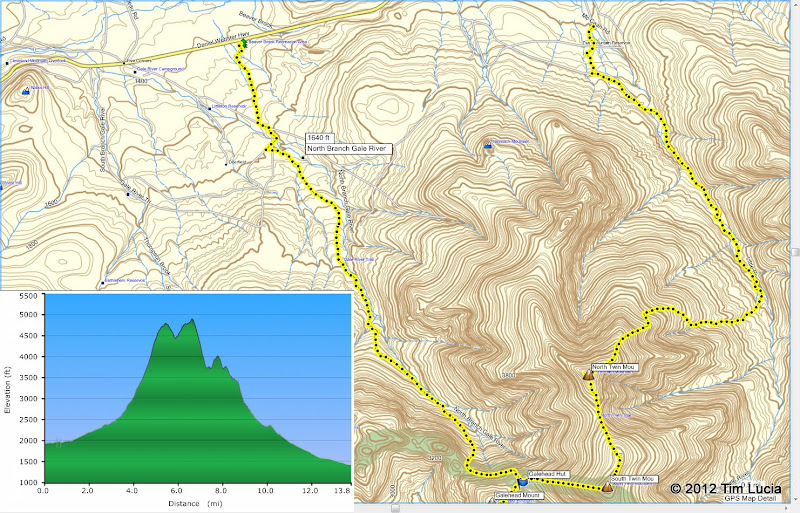
We had plans to bag these three peaks on 12/21 but with road closings and the weather, we stayed away. Therefore, we are looking to possibly do a loop over the Twins to Galehead (or vice versa) by using the following entry/exit points.

Beaver Brook Rest Area to Gale River Trail - It appears we can following a XC trail, approx. 4289' to Gale River Rd and then a bit further to the trailhead, so perhaps a mile each way.

Little River Rd to N. Twin Trail - From the map, it appears that this is a similar distance and the availability of a XC trail from the end of Little River Rd to Haystack Rd and then to trailhead.

If anyone that has done these routes, does a mile from where we would park our vehicles sound about right or is it a bit further? With 12 mile loop from the trailheads, we just want to be certain that these entrance/exits points distances and broken out XC trails are in our favor.

Thanks
 
I am tentatively planning a trip on 12/31, if you are interested. The traverse from Little River Road to the Beaver Brook ski area goes through a campsite (campsite #3, it has been marked in previous years) - turn right from Gale River TH, left to follow the road where it turns left, and then go into the first campsite on the right, and the ski trail is visible in the back on the left. You can see the right-left-right about a mile from the end, on the top left of the track.

Garmin.jpg


I have 13.8 +4100 -4300 feet from my GPS.

Tim
 
Last edited:
I would love to but I'll be in NY celebrating my 25th wedding aniversary. However your 13.8 provides me with the correct estimate that the added mileage was close to 2 miles. We may be doing this loop the weekend after New Year's (5th) so if you don't hike on 12/31, send me a note. If you do this loop and can provide additional information, I will appreciate that as well. We have a group of 4-5 guys that hike together.

Thanks for that info and happy New Year.
 
The traverse from Little River Road to the Beaver Brook ski area goes through a campsite
That's actually from Gale River Rd

I have always parked at Five Corners and hiked in the road, it's half a mile longer but easy walking without snowshoes which are needed on the ski trail and you avoid the parking fee
 
Yes, the campsite itself is on Gale River Road. The route itself leaves from the end of Little River Road, follows the old North Twin Trail, or the snowmobile tail, to Haystack Road to the summer / new North Twin Trail, to the Gale River Trail to the summer trailhead, onto Gale River Road, and then through campsite 3, and thence on the Beaver Brook XC system to Beaver Brook parking on route 3. I just left all the middle part out, Roy.

And yes, you can do the 5 corners trick if you prefer. I splurge $20/year on the sticker so I don't have to think about it.

Tim
 
A mile is about right, little or no elevation change. It's been years since I've done the Beaver Brook entry but it should be easy to follow as it's a well known option for getting to the Gale River Trail. If I recall, staying right on your way in gets you there.
 
Top