
Mudrat
Member
Disclaimer
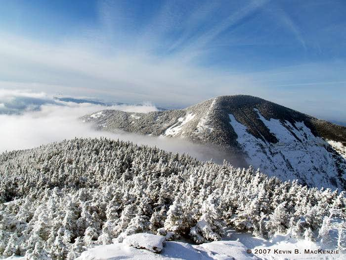
Giant's East Face taken several years ago from RPR.
PICTURES
Introduction
The view of Giant’s East Face from the summit of Rocky Peak Ridge is one of my favourite Adirondack views, dramatic and seemingly vertical. I’d visited it twice before in summer conditions and wanted to see it in winter so I created a route that would take me on a descent/ascent of the East Face as well as a descent/ascent of the Eagle…something that didn’t work out in the end due to the recent freeze-thaw cycle that was a little too heavy on the ‘thaw’ side. I set my itinerary to allow for both, however.
Approach
Rising at 4:00 a.m., I set foot on the trail at 5:00 a.m. exactly which allowed for a relaxing climb in total darkness. There’s something incredibly peaceful about a winter trail lit only by a headlamp especially while alone in the woods. The soft glow of morning banished the darkness while I was on the ridge about 2 miles into the trek. I continued to use the headlamp until it was bright enough to judge depth; the trail was a mess of amazingly deep post-holes.
This was a birthday celebration hike for me and I felt my age…or the heavy pack, hopefully the latter. I felt like I was moving at a snail’s pace and took more breaks than usual. None-the-less, I arrived at the edge of the East Face’s upper southern edge (just left of the ‘view’ sign partway down Giant’s flank en route to Rocky Peak Ridge) at 7:30 a.m. I was trying to time it with sunrise, but the heavy clouds gave little hope for a brilliant display. Grays and blues dominated the color scheme.
I’d been wearing microspikes which bit well into the icy compacted trail, but it was time to get out the axes, crampons and helmet. The temp was somewhere in the teens with a light breeze. It took mere minutes for my hands to become numb while changing gear. I knew it would take a good 30 minute to regain feeling… I just needed to get moving. My wooden fingers fumbled with the camera’s controls to take pictures.
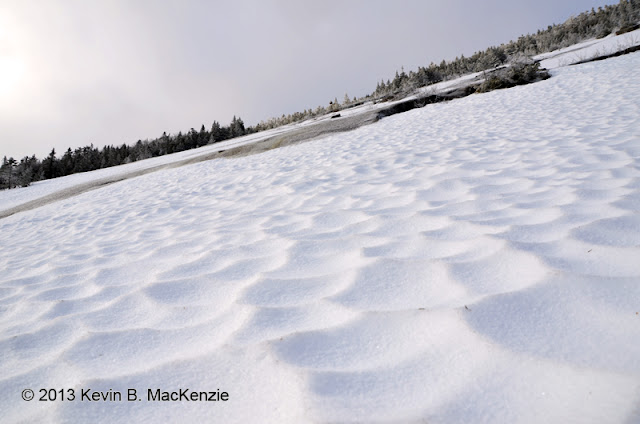
Looking across the massive slide, the snowpack was supportive and broken by fields of blue-gray ice. The dominant ledge that dissects the upper slide from the lower face is only a rounded ledge of steeper slab at the southern edge. As usual, I said a prayer and descended staying near the edge until the pitch dropped. I then traversed diagonally downward (about 800 vertical feet over 1,400 ground feet) across the supportive neve and ice fields. The slide has plenty of small alders, so there’s some natural protection in many areas below the ledge and nearly all the way across to the primary drainage. The descent took a bit less the 45 minutes.
The Climb
At 8:30 a.m. I was standing just up from the primary runout reflecting on two ascents a couple years ago with Rich McKenna, one in the early evening and another slippery climb the following day in the pouring rain up the route from which I just descended. I spent about 10 minutes studying the ledges while eating a snack. Much of ledge-set was beyond my skill level/comfort zone, some overhanging. I knew of at least three weaknesses, however. I spotted one during the descent…several alternating ramps of ice that seemed to provide access to the upper slab. Another was a bit left of the large cleft in the face where the east face meets the south-eastern slab. It was fairly protected with tree-cover (I ascended this way years ago using trees and a crevasse formed by the disjointed piece of slab). Both seemed like conservative choices (given the context in which I’m speaking). I wanted to find something slightly more challenging yet subjectively safe since I was solo. I spotted a flow of ice to the right of the overhanging ledges. I knew this led to the northern edge of the central tributary since I’d descended it with Rich. Well, I was relatively sure this was our descent route since the ice changed its appearance considerably.
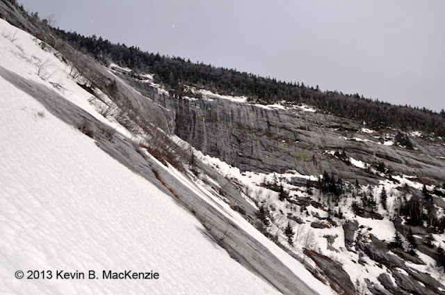
Approaching the base of the ledges.
The slope from the runout is moderate for a while, comfortable trekking up supportive snow and bands of ice covered ledges. The cliff-band sits at about 3,950 or so in elevation and the pitch increases with elevation until you’re climbing steadily up a 45 degree incline. I aimed for a block of ice that had carved a channel in the snow after falling during the recent melt. Just beyond lay a beautiful ice flow over about 75 feet of elevation gain. Some clumps of trees and exposed moss were near the top. The slide sprawled below. To the left the cliff was adorned with icicles for hundreds of feet. To the right lay steep slab encased in ice and the aforementioned cleft. Yes…I love the East Face, this area in particular!
Again, I studied it to make sure there were no surprises since I’m not really an ice climber by nature. The slope varied from about 45 degrees to roughly 75 degrees. The ice was soft, supportive and only about an inch thick in some places. The axes required a more delicate touch to avoid striking the underlying stone. Small platforms of flat ice broke the slope every now and again, something that comforted me and allowed me to take pictures with the hand not gripping the ax. The highest slope was near the top as I traversed around some vegetation and up a narrow drainage fat with ice. The lip of the central tributary was just beyond…above an island of trees where I sat on a mound of snow and relaxed. The more technical portion of the climb had taken about a half-hour. Hard scalloped neve coated the central (highest) tributary that leads to the summit of Giant.
...con't below.
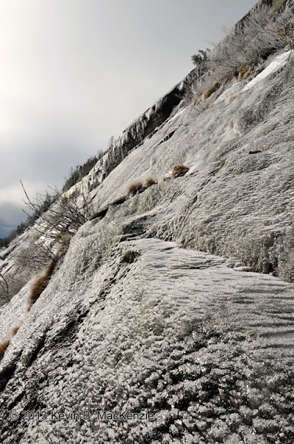
Looking south, partway up the climb to the right of the ledges. The perspective makes it look slightly steeper than it is.
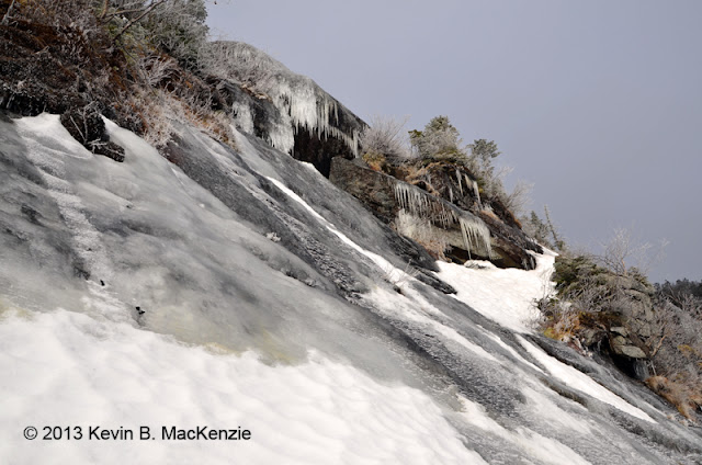
Nearing the traverse to the right.
A bit above the edge of the ledges, I planted the axes in the ice and sat while watching the clouds blow down the valley below. The main face of the slide below was obscured by the cliff band so; you wouldn’t want to slip at this point. Across the valley, Rocky Peak Ridge’s twin slides (sand and rubble) looked nearly vertical, an illusion of perspective. They were delicately outlined in snow. Meanwhile, the temperature had risen comfortably into the mid 20’s F and the sun was fighting through the cloud-cover. It was a perfect day.
The rest of the climb was less than exciting on low angle slab. As mentioned, the central tributary of the East Face reaches closest to the summit in both proximity and elevation. At the release-point, it’s only about a 200+ vertical foot bushwhack to the roof of Giant. I tried keeping my crampons on, but wading through hip-deep snow wasn’t working…the crust wasn’t quite supportive enough. My snowshoes, however, barely broke through the surface and 10 minutes later I walked out of the woods directly at the summit. It was 10:30 a.m.
Looking up the central tributary.
Exit
As mentioned, I planned to descend along the edge of the Eagle Slide. From the view I gleaned earlier in the morning, I doubted it would work out or be any fun…a shame since I had plenty of both time and energy. I took a bit to tramp through the krummholz to the top of one of the tributaries and looked down mostly open rock with a bit of water and snow trapped by vegetation in some areas. The safest and best option was to descend the trail. I again tossed around the idea of bushwhacking as I got lower on the ridge, but didn’t think climbing along the edge would be especially thrilling either. I called it a day and walked back down the post-hole highway arriving at the car at about 1:30 p.m.
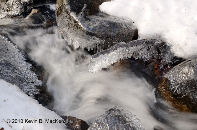
Stream and ice about 1/4 mile from the trailhead.
Thanks for reading...
Giant's East Face taken several years ago from RPR.
PICTURES
Introduction
The view of Giant’s East Face from the summit of Rocky Peak Ridge is one of my favourite Adirondack views, dramatic and seemingly vertical. I’d visited it twice before in summer conditions and wanted to see it in winter so I created a route that would take me on a descent/ascent of the East Face as well as a descent/ascent of the Eagle…something that didn’t work out in the end due to the recent freeze-thaw cycle that was a little too heavy on the ‘thaw’ side. I set my itinerary to allow for both, however.
Approach
Rising at 4:00 a.m., I set foot on the trail at 5:00 a.m. exactly which allowed for a relaxing climb in total darkness. There’s something incredibly peaceful about a winter trail lit only by a headlamp especially while alone in the woods. The soft glow of morning banished the darkness while I was on the ridge about 2 miles into the trek. I continued to use the headlamp until it was bright enough to judge depth; the trail was a mess of amazingly deep post-holes.
This was a birthday celebration hike for me and I felt my age…or the heavy pack, hopefully the latter. I felt like I was moving at a snail’s pace and took more breaks than usual. None-the-less, I arrived at the edge of the East Face’s upper southern edge (just left of the ‘view’ sign partway down Giant’s flank en route to Rocky Peak Ridge) at 7:30 a.m. I was trying to time it with sunrise, but the heavy clouds gave little hope for a brilliant display. Grays and blues dominated the color scheme.
I’d been wearing microspikes which bit well into the icy compacted trail, but it was time to get out the axes, crampons and helmet. The temp was somewhere in the teens with a light breeze. It took mere minutes for my hands to become numb while changing gear. I knew it would take a good 30 minute to regain feeling… I just needed to get moving. My wooden fingers fumbled with the camera’s controls to take pictures.
Looking across the massive slide, the snowpack was supportive and broken by fields of blue-gray ice. The dominant ledge that dissects the upper slide from the lower face is only a rounded ledge of steeper slab at the southern edge. As usual, I said a prayer and descended staying near the edge until the pitch dropped. I then traversed diagonally downward (about 800 vertical feet over 1,400 ground feet) across the supportive neve and ice fields. The slide has plenty of small alders, so there’s some natural protection in many areas below the ledge and nearly all the way across to the primary drainage. The descent took a bit less the 45 minutes.
The Climb
At 8:30 a.m. I was standing just up from the primary runout reflecting on two ascents a couple years ago with Rich McKenna, one in the early evening and another slippery climb the following day in the pouring rain up the route from which I just descended. I spent about 10 minutes studying the ledges while eating a snack. Much of ledge-set was beyond my skill level/comfort zone, some overhanging. I knew of at least three weaknesses, however. I spotted one during the descent…several alternating ramps of ice that seemed to provide access to the upper slab. Another was a bit left of the large cleft in the face where the east face meets the south-eastern slab. It was fairly protected with tree-cover (I ascended this way years ago using trees and a crevasse formed by the disjointed piece of slab). Both seemed like conservative choices (given the context in which I’m speaking). I wanted to find something slightly more challenging yet subjectively safe since I was solo. I spotted a flow of ice to the right of the overhanging ledges. I knew this led to the northern edge of the central tributary since I’d descended it with Rich. Well, I was relatively sure this was our descent route since the ice changed its appearance considerably.
Approaching the base of the ledges.
The slope from the runout is moderate for a while, comfortable trekking up supportive snow and bands of ice covered ledges. The cliff-band sits at about 3,950 or so in elevation and the pitch increases with elevation until you’re climbing steadily up a 45 degree incline. I aimed for a block of ice that had carved a channel in the snow after falling during the recent melt. Just beyond lay a beautiful ice flow over about 75 feet of elevation gain. Some clumps of trees and exposed moss were near the top. The slide sprawled below. To the left the cliff was adorned with icicles for hundreds of feet. To the right lay steep slab encased in ice and the aforementioned cleft. Yes…I love the East Face, this area in particular!
Again, I studied it to make sure there were no surprises since I’m not really an ice climber by nature. The slope varied from about 45 degrees to roughly 75 degrees. The ice was soft, supportive and only about an inch thick in some places. The axes required a more delicate touch to avoid striking the underlying stone. Small platforms of flat ice broke the slope every now and again, something that comforted me and allowed me to take pictures with the hand not gripping the ax. The highest slope was near the top as I traversed around some vegetation and up a narrow drainage fat with ice. The lip of the central tributary was just beyond…above an island of trees where I sat on a mound of snow and relaxed. The more technical portion of the climb had taken about a half-hour. Hard scalloped neve coated the central (highest) tributary that leads to the summit of Giant.
...con't below.
Looking south, partway up the climb to the right of the ledges. The perspective makes it look slightly steeper than it is.
Nearing the traverse to the right.
A bit above the edge of the ledges, I planted the axes in the ice and sat while watching the clouds blow down the valley below. The main face of the slide below was obscured by the cliff band so; you wouldn’t want to slip at this point. Across the valley, Rocky Peak Ridge’s twin slides (sand and rubble) looked nearly vertical, an illusion of perspective. They were delicately outlined in snow. Meanwhile, the temperature had risen comfortably into the mid 20’s F and the sun was fighting through the cloud-cover. It was a perfect day.
The rest of the climb was less than exciting on low angle slab. As mentioned, the central tributary of the East Face reaches closest to the summit in both proximity and elevation. At the release-point, it’s only about a 200+ vertical foot bushwhack to the roof of Giant. I tried keeping my crampons on, but wading through hip-deep snow wasn’t working…the crust wasn’t quite supportive enough. My snowshoes, however, barely broke through the surface and 10 minutes later I walked out of the woods directly at the summit. It was 10:30 a.m.
Looking up the central tributary.
Exit
As mentioned, I planned to descend along the edge of the Eagle Slide. From the view I gleaned earlier in the morning, I doubted it would work out or be any fun…a shame since I had plenty of both time and energy. I took a bit to tramp through the krummholz to the top of one of the tributaries and looked down mostly open rock with a bit of water and snow trapped by vegetation in some areas. The safest and best option was to descend the trail. I again tossed around the idea of bushwhacking as I got lower on the ridge, but didn’t think climbing along the edge would be especially thrilling either. I called it a day and walked back down the post-hole highway arriving at the car at about 1:30 p.m.
Stream and ice about 1/4 mile from the trailhead.
Thanks for reading...