Mudrat
Member
Disclaimer
Duration: 12.75 hours
Benchmarks: Start 6:25 a.m., Orebed Lean-to: 8:20 a.m, Basin NE col: 10:45 a.m., Bottom East Face: 11:15 p.m., Summit: 2:30 p.m., Garden: 7:15 p.m.
Mileage/Elevation Gain: 16.5-17 miles/~5,300 feet elevation gain.
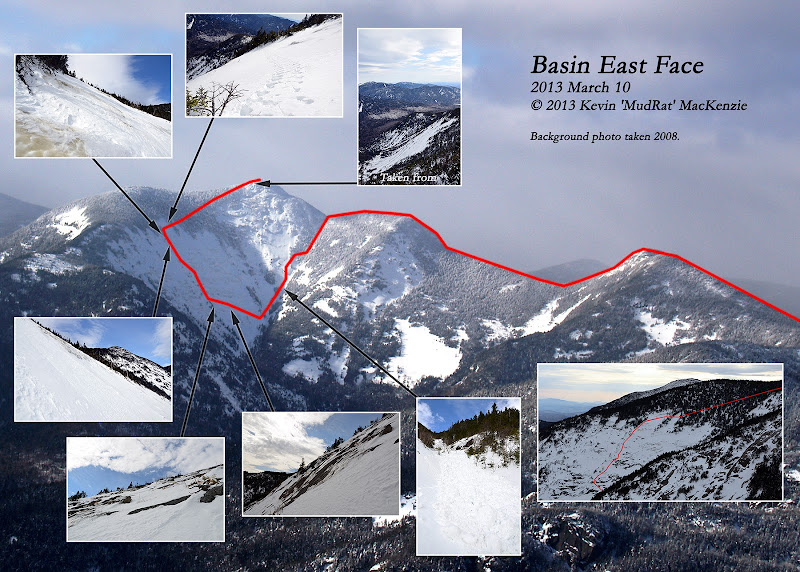
Route: Garden – DEC Interior Outpost—Saddleback Mountain—Basin NE col (below summit)—East Face—Basin Summit—Range Trail back over Saddleback to Garden.
Temperature: about 36-45 Fahrenheit with 5-40 m.p.h. winds
Trail Conditions: packed snow on trail, soft snow/ice/rock on face, 3-4 feet soft snow in forest.
Partner: none
Diet: 1 brownie, 5 starburst, 2 e-gel, a couple bites of banana bread, 3.5 litres water
Gear: Capilene, Columbia Titanium snow pants, Rain jacket (shell), Northface TKA100 micro-fleece, Black Diamond sabertooth crampons, BD viper & Charlet Moser Axar tools, Koflach Arctis boots, OR Absolute Zero mitts.
Pack Weight: 30 lbs.
PICTURE ALBUM
Introduction and Approach
Basin’s East Face has been my primary goal all winter; each prior climb a building block along the way. It’s hard to put into words what this particular climb meant. Again, my friend NP and I set our sights on it together many months ago. We tried to tackle it in February with Anthony Seidita after Saddleback’s Catastrophic Chaos slide, but weather and time constraints forced a change. Afterward, this winter’s ‘interesting’ weather complicated the logistics; there seemed to either be too much snow or not enough consolidated snow on the face. Fast forward to March; we received a copious amount of snow in a fairly short period which increased avalanche danger. Once again, it needed to consolidate. Finally, NP and I finalized plans to climb it on the tenth day of the month.
The day before, he was forced to cancel and the outing turned into a solo endeavor. I normally prepare myself for more ambitious day-hikes/climbs during the week prior especially if I feel it may test me physically or mentally. Basin east would do both. Psychologically, the change in plans left me re-evaluating logistics and trying to bolster my ambition.
Friends spent the night before the hike, each planning their own trek the next morning. I left them at the house (they know to make themselves at home) car-camped close to the trail-head so I could quickly roll out of the sleeping bag and start walking. I planned to climb the face before the snow became soft and unmanageable or, in the worst case, dangerous. A wet slab avalanche is nothing I planned to mess with. I arrived and crept into my sleeping bag at 1:15 a.m. (daylight savings time).
At 1:16 a.m. @$#%*!, the devil mouse spent until dawn trying to gnaw through my dash. By 2:15 a.m. I was seething with frustration and shoved some toilet paper in each ear as earplugs. I carefully hung my watch close to my head so the high-pitched beeping of the alarm would awaken me at 4:30 a.m. Sleep then came quickly. The slam of a car door snapped me out of a dream at 6:15 a.m. springing out of my bag in a grumbling panic, I found myself walking some 10 minutes later nursing such thoughts as, “Should I should just scrap the day because I’m so tired and it’s so late? What will the conditions be like…etc.” So the adventure began...
Given how I felt, I planned to walk slowly yet consistently; I was too tired and frustrated to do otherwise especially when I saw the bright sun shining on the top of Basin around 7:30 a.m. It would have hours to soften and I didn't want to walk eight miles for naught though I did have a contingency plan that would still allow me to bushwhack to its summit. Thankfully, the trail was like a concrete highway. This allowed a faster pace and I arrived at the col just northeast of the summit (where my bushwhack/descent began) at 10:45 a.m.
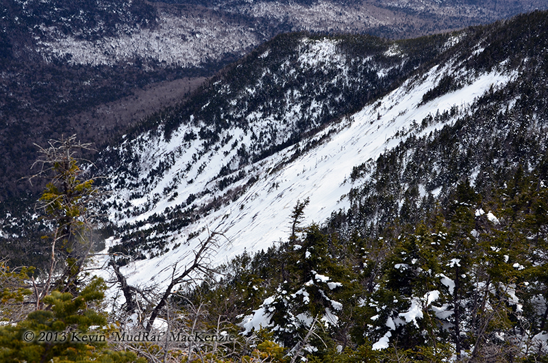
Summer bushwhacking down the col/gully can be difficult. It’s riddled with tightly knit trees and man-eating sod-holes. There was enough of a snow pack to keep me above the forest floor since it was semi-supportive. When combined with gravity, the descent down about 800 vertical feet was pleasant and fun. Fifteen minutes after leaving the trail, I broke through the tree line onto some open slab. Rolling snow created lines in the surface, an indicator that the day before was quite warm. Some were over 12” in diameter when they came to rest. About 3/4 of the way down, an area of beautiful ferns and grasses in summer, was now home to the remnants of a small avalanche from the opposing ridge. I felt my senses awaken as a feeling of extreme caution swept over me. My thoughts reflected on NP's last email the night before, "Take care of avalanche conditions if the weather gets too warm." The warning stayed with me all day.
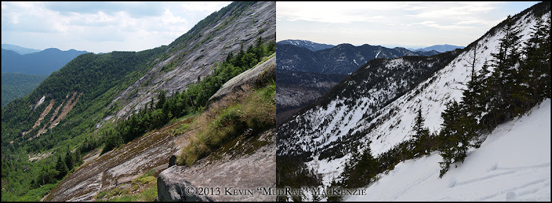
Summer and winter conditions looking south down the drainage between the East Face and opposing ridge.
Underfoot, the two-foot thick layer of small icy blocks (about 200 feet long) was locked tightly together, a stark contrast to the soft surrounding snow. I changed into climbing gear and assessed several route options just below under a protected area near a grove of trees that separate the east and east-southeast flanks of the mountain. It would be a mixed climb...ice, snow and rock.
East Face Proper
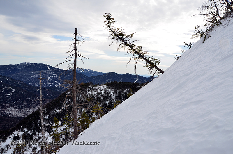
A route up the right side of the face looked tempting, but I wanted to follow a line near the center, something near what I climbed last July in combination with one that NP suggested. It followed adjacent to what few trees grew in a sparse line up the center. Even a single small tree trunk offered a point of protection if I grew tired or felt too exposed. I was alone and didn't want to end up in a precarious position. Meanwhile, a weather front neared and the wind increased. The high-level cloud cover giving it an eerie forlorn appearance at times.
I settled on a route that started at the bottom right of the primary slab (roughly 1,500 feet across and about 800 feet high depending on where you measure) and traversed up at a 45-degree angle toward a run of ice and snow between two exposed rock ledges. The snow was deep and moderately soft as I broke through nearly to my knees. It eventually thinned in depth. I could feel the points of the crampons biting into ice one moment, then scraping on stone the next. In the latter case, I was unconcerned since almost all of the face is rough with small facets, steps, and holds. My front-points would slide negligibly before catching on something supportive. If I felt ice, then a firm kick sufficed.
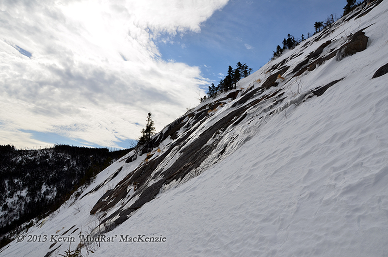
Looking south across the East Face from the bottom pitch near some open rock.
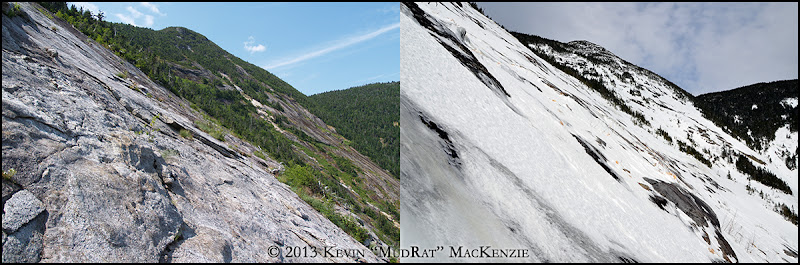
Looking up toward the summit crown from partway up the face. The shots aren't from the identical location, but you get the idea.
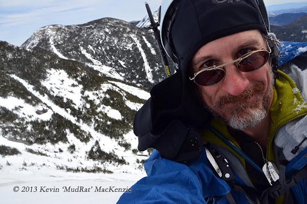
Afterward, I climbed in a sinuous line upward toward the lower left-hand side of the central and highest slide tributary. The slope was generally between about 40 and 45 degrees, though I’d occasionally happen upon steeper section along the way. Feeling some fatigue, I sought the cover of a lone tree and carved a seat in the snow above the 4” trunk. It was nice to be able to shoot pictures and video from a protected area without concern. My other option included clinging from three points of contact while using my free hand manipulate the lens and shutter. I also absorbed the magnificent scenery. The gully from which I descended was far below, merely another snowy accent in the network of slides and cliffs. The summit was far above to the right, but a distant dream at this point. The face sprawled 700-800 feet to either side and fell away hundreds of feet below. The bedrock peeked through on occasion surrounded by a rim of rotten ice which transitioned to the solid layer I sought with my crampons. I was alone with the wind and my own thoughts in one of the more remote areas of the High Peaks. I felt close to God, another reason I love to occasionally explore solo.
About three quarters of the way up as it approached noon, the sun came out again. It was beautiful, but the snow noticeably softened, an uncomfortable feeling on the steepest pitches near the top. I was near enough to the top for a maintained push toward a nice ice flow where I could really protect myself. It was good ice. Once I embedded my axes and set my crampon points, I too another photography break, caught my breath and studied the next challenge; a traverse across the tributary. For my own sanity, I tend to break the strenuous days into a series of segmented goals.
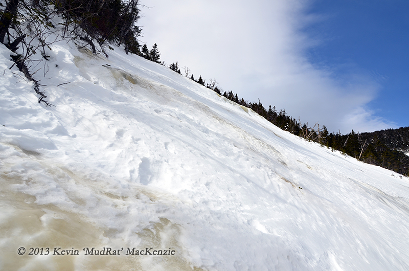
Looking up the central tributary from the top of the face.
Duration: 12.75 hours
Benchmarks: Start 6:25 a.m., Orebed Lean-to: 8:20 a.m, Basin NE col: 10:45 a.m., Bottom East Face: 11:15 p.m., Summit: 2:30 p.m., Garden: 7:15 p.m.
Mileage/Elevation Gain: 16.5-17 miles/~5,300 feet elevation gain.
Route: Garden – DEC Interior Outpost—Saddleback Mountain—Basin NE col (below summit)—East Face—Basin Summit—Range Trail back over Saddleback to Garden.
Temperature: about 36-45 Fahrenheit with 5-40 m.p.h. winds
Trail Conditions: packed snow on trail, soft snow/ice/rock on face, 3-4 feet soft snow in forest.
Partner: none
Diet: 1 brownie, 5 starburst, 2 e-gel, a couple bites of banana bread, 3.5 litres water
Gear: Capilene, Columbia Titanium snow pants, Rain jacket (shell), Northface TKA100 micro-fleece, Black Diamond sabertooth crampons, BD viper & Charlet Moser Axar tools, Koflach Arctis boots, OR Absolute Zero mitts.
Pack Weight: 30 lbs.
PICTURE ALBUM
Introduction and Approach
Basin’s East Face has been my primary goal all winter; each prior climb a building block along the way. It’s hard to put into words what this particular climb meant. Again, my friend NP and I set our sights on it together many months ago. We tried to tackle it in February with Anthony Seidita after Saddleback’s Catastrophic Chaos slide, but weather and time constraints forced a change. Afterward, this winter’s ‘interesting’ weather complicated the logistics; there seemed to either be too much snow or not enough consolidated snow on the face. Fast forward to March; we received a copious amount of snow in a fairly short period which increased avalanche danger. Once again, it needed to consolidate. Finally, NP and I finalized plans to climb it on the tenth day of the month.
The day before, he was forced to cancel and the outing turned into a solo endeavor. I normally prepare myself for more ambitious day-hikes/climbs during the week prior especially if I feel it may test me physically or mentally. Basin east would do both. Psychologically, the change in plans left me re-evaluating logistics and trying to bolster my ambition.
Friends spent the night before the hike, each planning their own trek the next morning. I left them at the house (they know to make themselves at home) car-camped close to the trail-head so I could quickly roll out of the sleeping bag and start walking. I planned to climb the face before the snow became soft and unmanageable or, in the worst case, dangerous. A wet slab avalanche is nothing I planned to mess with. I arrived and crept into my sleeping bag at 1:15 a.m. (daylight savings time).
At 1:16 a.m. @$#%*!, the devil mouse spent until dawn trying to gnaw through my dash. By 2:15 a.m. I was seething with frustration and shoved some toilet paper in each ear as earplugs. I carefully hung my watch close to my head so the high-pitched beeping of the alarm would awaken me at 4:30 a.m. Sleep then came quickly. The slam of a car door snapped me out of a dream at 6:15 a.m. springing out of my bag in a grumbling panic, I found myself walking some 10 minutes later nursing such thoughts as, “Should I should just scrap the day because I’m so tired and it’s so late? What will the conditions be like…etc.” So the adventure began...
Given how I felt, I planned to walk slowly yet consistently; I was too tired and frustrated to do otherwise especially when I saw the bright sun shining on the top of Basin around 7:30 a.m. It would have hours to soften and I didn't want to walk eight miles for naught though I did have a contingency plan that would still allow me to bushwhack to its summit. Thankfully, the trail was like a concrete highway. This allowed a faster pace and I arrived at the col just northeast of the summit (where my bushwhack/descent began) at 10:45 a.m.
Summer bushwhacking down the col/gully can be difficult. It’s riddled with tightly knit trees and man-eating sod-holes. There was enough of a snow pack to keep me above the forest floor since it was semi-supportive. When combined with gravity, the descent down about 800 vertical feet was pleasant and fun. Fifteen minutes after leaving the trail, I broke through the tree line onto some open slab. Rolling snow created lines in the surface, an indicator that the day before was quite warm. Some were over 12” in diameter when they came to rest. About 3/4 of the way down, an area of beautiful ferns and grasses in summer, was now home to the remnants of a small avalanche from the opposing ridge. I felt my senses awaken as a feeling of extreme caution swept over me. My thoughts reflected on NP's last email the night before, "Take care of avalanche conditions if the weather gets too warm." The warning stayed with me all day.
Summer and winter conditions looking south down the drainage between the East Face and opposing ridge.
Underfoot, the two-foot thick layer of small icy blocks (about 200 feet long) was locked tightly together, a stark contrast to the soft surrounding snow. I changed into climbing gear and assessed several route options just below under a protected area near a grove of trees that separate the east and east-southeast flanks of the mountain. It would be a mixed climb...ice, snow and rock.
East Face Proper
A route up the right side of the face looked tempting, but I wanted to follow a line near the center, something near what I climbed last July in combination with one that NP suggested. It followed adjacent to what few trees grew in a sparse line up the center. Even a single small tree trunk offered a point of protection if I grew tired or felt too exposed. I was alone and didn't want to end up in a precarious position. Meanwhile, a weather front neared and the wind increased. The high-level cloud cover giving it an eerie forlorn appearance at times.
I settled on a route that started at the bottom right of the primary slab (roughly 1,500 feet across and about 800 feet high depending on where you measure) and traversed up at a 45-degree angle toward a run of ice and snow between two exposed rock ledges. The snow was deep and moderately soft as I broke through nearly to my knees. It eventually thinned in depth. I could feel the points of the crampons biting into ice one moment, then scraping on stone the next. In the latter case, I was unconcerned since almost all of the face is rough with small facets, steps, and holds. My front-points would slide negligibly before catching on something supportive. If I felt ice, then a firm kick sufficed.
Looking south across the East Face from the bottom pitch near some open rock.
Looking up toward the summit crown from partway up the face. The shots aren't from the identical location, but you get the idea.
Afterward, I climbed in a sinuous line upward toward the lower left-hand side of the central and highest slide tributary. The slope was generally between about 40 and 45 degrees, though I’d occasionally happen upon steeper section along the way. Feeling some fatigue, I sought the cover of a lone tree and carved a seat in the snow above the 4” trunk. It was nice to be able to shoot pictures and video from a protected area without concern. My other option included clinging from three points of contact while using my free hand manipulate the lens and shutter. I also absorbed the magnificent scenery. The gully from which I descended was far below, merely another snowy accent in the network of slides and cliffs. The summit was far above to the right, but a distant dream at this point. The face sprawled 700-800 feet to either side and fell away hundreds of feet below. The bedrock peeked through on occasion surrounded by a rim of rotten ice which transitioned to the solid layer I sought with my crampons. I was alone with the wind and my own thoughts in one of the more remote areas of the High Peaks. I felt close to God, another reason I love to occasionally explore solo.
About three quarters of the way up as it approached noon, the sun came out again. It was beautiful, but the snow noticeably softened, an uncomfortable feeling on the steepest pitches near the top. I was near enough to the top for a maintained push toward a nice ice flow where I could really protect myself. It was good ice. Once I embedded my axes and set my crampon points, I too another photography break, caught my breath and studied the next challenge; a traverse across the tributary. For my own sanity, I tend to break the strenuous days into a series of segmented goals.
Looking up the central tributary from the top of the face.
Last edited: