
I've been hiking in the White Mountains now for six+ years and for the last several, a trip into the Great Gulf has been on my bucket list. On Sunday, August 11, I had an opportunity to combine this trip with a "need" to tag Adams 5 for the Trailwrights. Sure, there are easier ways to get to Adams 5, not that any way to any of the Adams peaks is easy. This loop exceeded my expectations in every way. 11+ hours for 15+ miles and 6,000+ feet of elevation - worth every bit and more. The forecast was a bit iffy, predicting a trend towards mostly cloudy with summits in and out. On the way up, the entire southwest (Pemi) side of the Presidentials were covered in clouds. Turning up 16 in Gorham, however, showed blue skies with the majority of the peaks already out.
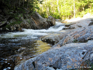
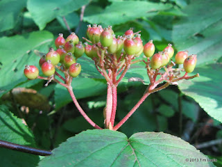
Pool on the Peadbody; Hobble bush berries--first sign of autumn
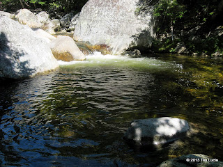
The Great Gulf trail starts out by immediately crossing the west branch of the Peabody River on a suspension bridge, and follows it all the way to the junction with Six Husbands, crossing twice more - once on a second suspension bridge and again on your own. This third crossing was doable right where the trail crossed, although I did partially submerged a boot. The trail itself resembles the Lincoln Woods trail, without the RR ties - it is an easy grade, former logging road, following a beautiful river. I stopped many times and climbed down to stand on the rocks and check out cascades and pools. With the air temps in the 50s, it wasn't warm enough to take a swim, but some of the pools were clearly deep enough to jump into.
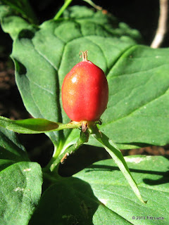
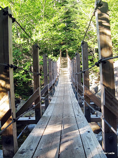
Red trillium berry; Second suspension bridge crossing of the Peabody
The tent sites came and went, and I crossed the Peabody River again. Somewhere in this stretch I ran into a guy named Rich who was a VFTT member (before the crash), and he correctly guessed my identity. This happens once or twice per year, and isn't a surprise any more. I invited him to return if he wished. His goal was Madison Gulf and we went our separate ways here. Beyond this point, the trail gets wilder, with more rocks, more undulations, and more mud. Beyond the second bridge, the first familiar landmark appeared - Clam Rock. I enjoyed this area for a while, including a nearby deep pool with its cascade. It looked plenty deep enough to swim and the current seemed minimal, and the outflow guarded. If it had been as hot as early July, I'd have gone in.
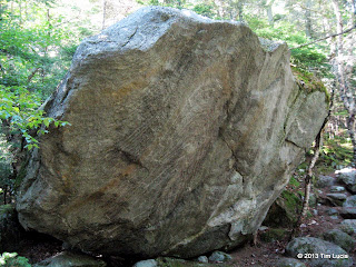
Clam Rock; Best pool yet - almost at the Six Husband's Jct.
The next landmark is the junction with Six Husbands and Wamsutta. The Great Gulf Trail continues onward at this point on its way to the Sphinx Trail (some outbound hikers informed me it was unavoidably wet) and thence to the ravine headwall en route to Washington. On a return trip, I'll continue to the headwall. I descended on the Six Husbands Trail to cross the Peabody River for the final time - this time, there is no bridge, but sufficient stepping stones existed to cross right at the trail, although some were submerged an inch or two.
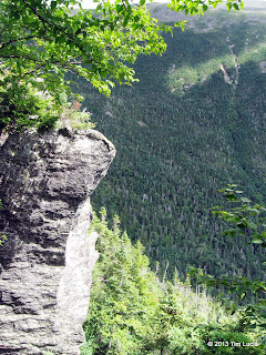
View into Jefferson Ravine from ladders; Jefferson's Knee
Six Husbands follows Jefferson Brook for a while, before turning due west and attacking the steep southern flank of Jefferson Ravine, known as Jefferson's Knee (North Knee). Sections down low were wet and muddy, but higher up on the steeps, it was thankfully much drier. I took it extra slow and careful through the very steep section, not wanting to have to head back down with a rolled ankle. There are boulder caves to go around or through, with some guessing (an a small cairn or two) as to the direction of the trail (the actual direction is never in doubt; once you make a decision you'll know quickly enough if it was the right one.) There are two pairs of ladders here which go nearly straight up. Atop the 4th ladder is a section with a polished slab below you and an overhanging ledge above you. I crab-walked up backwards to avoid a small wet section. This is a definite no-fall zone. Above this section, the trees get shorter and the trail winds back and forth around the boulders. I had lunch looking into the Great Gulf on one side and Jefferson Ravine on the other. There were plenty of wild blueberries here for dessert.
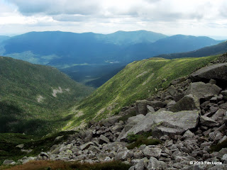
View through Jefferson Ravine to Carter Range; Adams from Gulfside
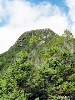
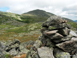
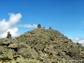
Once off the steeps and out of the trees, the route goes through an alpine zone, alternating between grasses, low bushes and rocks. The famous "Jefferson Beach", which is shaped like the USA, and holds snow into July, lies between you and the summit. Passing to the right of the beach, the trail winds its way up until it crosses the Gulfside, and then the Jefferson Loop, which takes you to the giant cairn on the north side of the summit. The clouds were thickening, and although Adams was completely obscured, Jefferson's top was not. I didn't stay long and headed north along the Gulfside in search of Adams 5. Adams 5 is a pretty short pile of rocks, maybe 40 feet tall, just east of the Gulfside Trail. This was my goal peak for the hike, but it was pretty unspectacular, as peaks go on this loop.
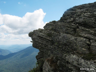
Madison; Facial rock formation on the Osgood
After sumitting Adams, I headed on to Madison to check out the new hut - have only been up in winter since it was rebuilt - very nice. I talked to the croo for a short while, bought a peanut butter cookie, and filled up a water bottle. From the hut I jumped on the Osgood up and over the summit. From the top, the Osgood was all new trail to me - and another fine trail it is - following the top of Osgood Ridge for over a mile, before finally dropping back into the trees. In this stretch, I had company, Jeremy, who'd come from Lake of the Clouds. We walked together on and off and I offered him a ride back to Pinkham for his car, rather than taking Old Jackson Road.
All Photos
Tim
Pool on the Peadbody; Hobble bush berries--first sign of autumn
The Great Gulf trail starts out by immediately crossing the west branch of the Peabody River on a suspension bridge, and follows it all the way to the junction with Six Husbands, crossing twice more - once on a second suspension bridge and again on your own. This third crossing was doable right where the trail crossed, although I did partially submerged a boot. The trail itself resembles the Lincoln Woods trail, without the RR ties - it is an easy grade, former logging road, following a beautiful river. I stopped many times and climbed down to stand on the rocks and check out cascades and pools. With the air temps in the 50s, it wasn't warm enough to take a swim, but some of the pools were clearly deep enough to jump into.
Red trillium berry; Second suspension bridge crossing of the Peabody
The tent sites came and went, and I crossed the Peabody River again. Somewhere in this stretch I ran into a guy named Rich who was a VFTT member (before the crash), and he correctly guessed my identity. This happens once or twice per year, and isn't a surprise any more. I invited him to return if he wished. His goal was Madison Gulf and we went our separate ways here. Beyond this point, the trail gets wilder, with more rocks, more undulations, and more mud. Beyond the second bridge, the first familiar landmark appeared - Clam Rock. I enjoyed this area for a while, including a nearby deep pool with its cascade. It looked plenty deep enough to swim and the current seemed minimal, and the outflow guarded. If it had been as hot as early July, I'd have gone in.
Clam Rock; Best pool yet - almost at the Six Husband's Jct.
The next landmark is the junction with Six Husbands and Wamsutta. The Great Gulf Trail continues onward at this point on its way to the Sphinx Trail (some outbound hikers informed me it was unavoidably wet) and thence to the ravine headwall en route to Washington. On a return trip, I'll continue to the headwall. I descended on the Six Husbands Trail to cross the Peabody River for the final time - this time, there is no bridge, but sufficient stepping stones existed to cross right at the trail, although some were submerged an inch or two.
View into Jefferson Ravine from ladders; Jefferson's Knee
Six Husbands follows Jefferson Brook for a while, before turning due west and attacking the steep southern flank of Jefferson Ravine, known as Jefferson's Knee (North Knee). Sections down low were wet and muddy, but higher up on the steeps, it was thankfully much drier. I took it extra slow and careful through the very steep section, not wanting to have to head back down with a rolled ankle. There are boulder caves to go around or through, with some guessing (an a small cairn or two) as to the direction of the trail (the actual direction is never in doubt; once you make a decision you'll know quickly enough if it was the right one.) There are two pairs of ladders here which go nearly straight up. Atop the 4th ladder is a section with a polished slab below you and an overhanging ledge above you. I crab-walked up backwards to avoid a small wet section. This is a definite no-fall zone. Above this section, the trees get shorter and the trail winds back and forth around the boulders. I had lunch looking into the Great Gulf on one side and Jefferson Ravine on the other. There were plenty of wild blueberries here for dessert.
View through Jefferson Ravine to Carter Range; Adams from Gulfside
Once off the steeps and out of the trees, the route goes through an alpine zone, alternating between grasses, low bushes and rocks. The famous "Jefferson Beach", which is shaped like the USA, and holds snow into July, lies between you and the summit. Passing to the right of the beach, the trail winds its way up until it crosses the Gulfside, and then the Jefferson Loop, which takes you to the giant cairn on the north side of the summit. The clouds were thickening, and although Adams was completely obscured, Jefferson's top was not. I didn't stay long and headed north along the Gulfside in search of Adams 5. Adams 5 is a pretty short pile of rocks, maybe 40 feet tall, just east of the Gulfside Trail. This was my goal peak for the hike, but it was pretty unspectacular, as peaks go on this loop.
Madison; Facial rock formation on the Osgood
After sumitting Adams, I headed on to Madison to check out the new hut - have only been up in winter since it was rebuilt - very nice. I talked to the croo for a short while, bought a peanut butter cookie, and filled up a water bottle. From the hut I jumped on the Osgood up and over the summit. From the top, the Osgood was all new trail to me - and another fine trail it is - following the top of Osgood Ridge for over a mile, before finally dropping back into the trees. In this stretch, I had company, Jeremy, who'd come from Lake of the Clouds. We walked together on and off and I offered him a ride back to Pinkham for his car, rather than taking Old Jackson Road.
All Photos
Tim