Mount Ascutney

vftt.org

Help Support vftt.org:

This site may earn a commission from merchant affiliate links, including eBay, Amazon, and others.

Raymond

Well-known member
Joined
Sep 4, 2003
Messages
1,536
Reaction score
59
Location
My gut is telling me no... but my gut is also very
Is there a Mount Ascutney expert in the house?

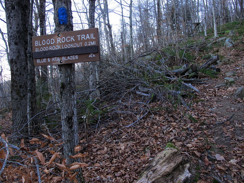
I climbed the mountain on Monday, taking the Windsor Trail up and down. I didn’t get started on the hike until 1:45 p.m., so I didn’t think I had time to make a loop out of the hike, by descending the Brownsville Trail.

However, I did take the Blood Rock Trail, which my (fifth edition) Day Hiker’s Guide says reconnects with the Windsor Trail a tenth of a mile before the Windsor Trail’s junction with the Futures Trail, near the summit. But I couldn’t see that the Blood Rock Trail went past Blood Rock. It was a dead-end spur.

There was just a steep-looking drop-off (I didn’t get too close to the edge, so if there was a ladder there, I wouldn’t have seen it) and a slightly less-steep looking gorge to the right. No sign of any trail continuing, although the map in the book shows the trail going through. So I backtracked to the 1903 Route and continued climbing on the Windsor Trail(s).

So I was wondering if the trail actually is there, or if it has been abandoned since 2006 and all trace of it obliterated, or what.
 
I don't consider myself an expert on Ascutney, although I have done it a few times as it has some great views given its location. I've always preferred the Weathersfield Trail...
 
Gee, nothing?

Here’s a picture I took. I assume the covered part of the sign said something about the distance to the summit.

10909278655_a78f45232e_c.jpg


No one here knows anything about the trail being truncated? I’m disappointed.
 
Well I haven't hiked the Windsor Trail in quite some time. I generally take the Brownsville or Weathersfield Trails as they're much more interesting. The last time I went to Blood Rock the trail continued on and rejoined the Windsor Trail, this was in the mid-to-late 90s most likely, perhaps as recently as 2000. My old state park map from 1993 shows it doing so as well. I've also noticed the Weathersfield Trail having been rerouted several times over the years. Right above Cascade Falls is different but I don't know when that happened. And lower down just after Little Cascade Falls looks to have changed around two years ago.

Hmm, after a little searching I found this http://www.vtstateparks.com/pdfs/ascutney_rec_guide.pdf which differs from my old map and which would lead me to conclude that the trail no longer continues past Blood Rock.
 
I couldn’t see any sign of it continuing, but my book, copyright 2006, said it did. ‘‘Swings west,’’ supposedly, and rejoins the Windsor Trail. I was just wondering why it was discontinued and curious about how it seemed to vanish so completely.

If it weren’t so far out of the way for me, I’d poke around some more, but it’s probably not worth it.

Well, thanks.
 
Mount Ascutney is my backyard… The upper section of the blood rock trail was deemed too steep and treacherous (though it's not really - just steep with loose rocks) so though I haven't been on the Windsor Trail in a while, I believe they covered that part of the trail over.

There is a plan for a mountain trail connecting the State Park/Campground with the Windsor Trail and ultimately the Brownsville Trail (my fav) - will be nice to do a Windsor Trail/Bville Trail loop without being on the road… not a lot of loop options on the mountain.
 
Thanks, Suebiscuit. Do you happen to know if the closed section went straight where the trail turns left to go to Blood Rock? That seemed like the one place where the trail might have been. Right around Blood Rock itself any continuation would have gone steeply downhill.

When I was there, I wasn’t even certain that the trail was supposed to continue beyond Blood Rock. That was what I thought I remembered reading in the book, but I hadn’t bothered bringing the book with me, so I couldn’t confirm it while I was there. Later, when I looked at the book again and saw the map showing the trail going on toward the summit, I wondered how I’d missed seeing it.

None of this matters, I’ll probably never go back, but I was curious.

Thanks very much for the information. Another Lost Trail.
 
I think the trail actually took a fairly sharp right up the (steep) hill if not at Blood Rock, then shortly after. Sounds like they did a good job masking the old trail. It wasn't very heavily used anyway - I recall there being a lot of branches, loose rock, leaves, etc. on it when I went down it several years ago… was kindof an ankle-buster, thus the closure. Next time I head up the Windsor Trail I'll take a look...
 
I don't recall any obvious trail that continues on. I didn't know there was supposed to be one so I wasn't looking for it though. The obvious trail just dead ends at that dropoff. I'll have to check it out next time I'm there.
 
Sue,
do you know much about the Weathersfield Trail? I used to hike Ascutney several times a year by the various trails before I moved away in 2001. Then there was a 5 or 6 year gap and the next time I went up that trail is had changed quite a bit.
 
Not sure when this happened, but it was rerouted to stay on the east side of cascade falls - used to follow an old logging road on the other side. Trails.com topo map shows the old crossing under the falls at approx. 380 meters:

http://www.trails.com/topo.aspx?lat=43.44452&lon=-72.4537&s=50&size=s&style=drgsr

There have been other smaller re-routes to make the trail less erosion-prone.

This is my second favorite trail on the mountain ;-)
 
Top