Adam's to Jefferson or.....

vftt.org

Help Support vftt.org:

This site may earn a commission from merchant affiliate links, including eBay, Amazon, and others.

marysgirl

New member
Joined
Feb 13, 2013
Messages
137
Reaction score
0
I need Jefferson and my friend needs Adam's. For all of you who have spent more time up there than I have, what is the best way to tackle the task of summitting and getting both? We had discussed going up Jewell and down Valley Way, or vice versa. Perhaps there is a better trail up than Jewell? Perhaps the other direction? The one time that I climbed Jefferson it was via caps ridge. Everything I have heard has been to stay off of that in winter, of course it is much more direct!!
 
Personally, I would go up Jewell and down Lowe’s Path. That way you can stop at Gray Knob if you need to take a break and fuel up before the descent. It requires a car spot, but so does Valley Way. The revere would also work. p.s. Jefferson road is closed in winter so doing it via the Caps would require a road walk, or skiing it.
 
Last edited:
Summiting and getting both is best done later winter as no matter how you approach it, it is potentially a real long day in winter. Obviously if the conditions are right it can be shorter day, but plan for the worst hope for the best. I would suggest an overnight at Gray Knob but if you insist parking at Lowes and heading to Jefferson via Gray Knob trail then cutting back via Gulfside to Lowes up to Adams and then back down Lowes is probably the best as you can always stop by Gray Knob on the way down. These trails get a lot of use in winter and no car spot (but its still a real long day).
 
I'd take Lowe's Path to the Randolph Path to Edmands Col and up to Jefferson, then go back to Edmand's Col and up the Gulfside and Israel Ridge to Adams, then down Lowe's.

If you needed to retreat before summiting Adams, you could go back down the Randolph Path.
 
If a car spot is available I would suggest up Jewell, Gulfside to Adams, then down either Lowes or Valley Way. I don't know off the top of my head but you're looking at about 5 miles of above treeline.
 
i know, its asking a lot, we should take turns, just trying to plan it out just in case we need to duck out - where would be the best spot....easiest up makes for more energy for the trek out in the open....stuff like that. Looking for opinions!!

While we are at it, what way would you guys go on a loop of Lafayette and Lincoln? I went south to north last time I went but I was worried about the ice descending bridal path....
 
I assume you are spotting a car, so I would agree that up Jewell, around on Gulfside, and descending on Valley Way is probably best. I don't like descending Jewell b/c of the potential for bad visibility to make routefinding difficult. I would avoid Randolph Path from Edmonds Col to GK/Perch b/c of similar routefinding issues (more of a problem is big snow years, I guess). I like descending Spur myself, passing Crag Camp on the way down, but Valley Way is probably easier for most.

For Lafayette/Lincoln, in winter, I hike north to south, keeping the prevailing winds behind me, and it's an easier escape off Little Haystack than Lafayette if the weather turns sour while on the ridge. I do the opposite direction in the summer, to avoid descending the steeper FW trail.
 
i know, its asking a lot, we should take turns, just trying to plan it out just in case we need to duck out - where would be the best spot....easiest up makes for more energy for the trek out in the open....stuff like that. Looking for opinions!!

While we are at it, what way would you guys go on a loop of Lafayette and Lincoln? I went south to north last time I went but I was worried about the ice descending bridal path....

Either way is about the same, you will need traction. I actually think its harder to descend Falling waters then the Bridal path.
 
i know, its asking a lot, we should take turns, just trying to plan it out just in case we need to duck out - where would be the best spot....easiest up makes for more energy for the trek out in the open....stuff like that. Looking for opinions!!

Come up with a bunch of options and then see what the weather allows for. If you are going to be above treeline, then try to hike with the wind. Planning to do a specific route on a specific day can be a setup for either disappointment or a dangerous situation (if you press on when you shouldn't).

As for specifics, given the length of the car drop, it might make more sense to go up Lowes and grab Jefferson via RP thru Edmunds col, then back and over Adams. Personally, I would stay at Gray Knob and make it a weekend! :)
 
I'd take Lowe's Path to the Randolph Path to Edmands Col and up to Jefferson, then go back to Edmand's Col and up the Gulfside and Israel Ridge to Adams, then down Lowe's.
I have climbed Jefferson in winter via Caps, Castle, Israel Ridge, and Lowes - Caps is not that hard except if you have to walk to the trailhead :)

With one car I would do as suggested and take Lowes Path to Edmands Path, nearing Edmands Col flip a coin as to which peak to climb first - you can't get fairer than that!

With two cars you need to decide if it is worth an extra half-hour (or more) of driving to save ~1000' of climb
 
Adams and Jefferson require good weather due to the mileage above treeline. Lowe's is a nice trip up Adams, I'd probably pick Lowe's. (If you need the protection of the trees on Valley Way, then you probably shouldn't be doing both peaks.) Could do both and then go back to Edmands Col and then pick up the Randolph. The Randolph does spend some time above treeline and scrub exiting Edmands. It felt longer the two times I've used it to exit Edmands col. IMO, the Jewell is a better foot way than Randolph IMO and doing Lowe's and Jewell would be a really nice trip, it does require the car spot though.

In the other three seasons, I prefer going up Falling Waters and down Greenleaf & OBP. In winter, I prefer going up OBP and down Falling Waters.

On a good day it doesn't really matter. On an iffy day, by going up OBP, you reach the hut where you can assess your options and know where you are (4200 ft.) The other way, you are just below Lil Haystack when you get a view of the ridge or fog. If it changes while you are on the ridge, it's easier, IMO, finding where the Falling Waters trail heads into the trees while you have to meander off of Lafayette to find where the trail enters the scrub above Greenleaf Hut.
 
Last edited:
I'd take Lowe's Path to the Randolph Path to Edmands Col and up to Jefferson, then go back to Edmand's Col and up the Gulfside and Israel Ridge to Adams, then down Lowe's.

If I recall from a previous thread and comments in the 4000 Footer Guide isn't Edmands Col area pretty treacherous in winter, with tricky snow fields and potentially dangerous sliding falls? I was under the impression it was best to do Madison/Adams together and Jefferson alone via Jewell for this reason. Can anyone who has been this way expand on why that is - very deep snow drifts/cornicing? Hard ice with potential for long dangerous slides?
 
Edmands Col has a well earned reputation for difficult winter travel. It channels the winds and makes travel in your intended direction often difficult. The prevailing winds tend to push down towards the Great Gulf, which is not a useful bailout route for anyone. The snow gets scoured out of there pretty well by the wind so deep drifts aren't often a major factor.
 
If going by Lowe's without a carspot it may be better to bag Jefferson first and have the wind at your back for the long jaunt above treeline to Adams. Much of the decision has to be made by the weather of the particular day and hours of that day. Also staying at Crag Camp is an option, though it doesn't have the stove its pretty accomodating with a decent sleeping bag. Could go to GK for Friday eve, loop the peaks Saturday and either head down or stay at either camp Sunday for less than one night at the AMC Hilton! ;)
 
The snow gets scoured out of there pretty well by the wind so deep drifts aren't often a major factor.

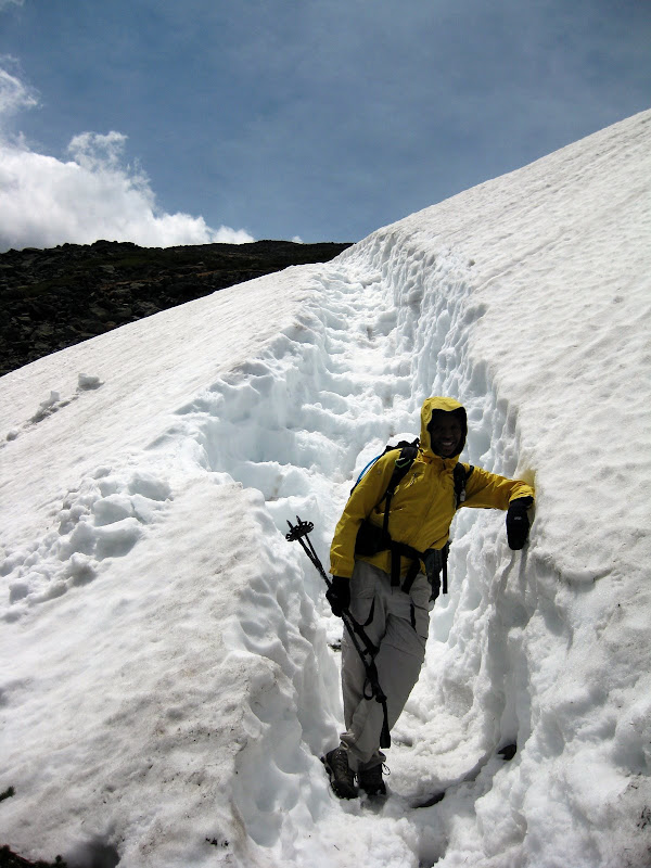
One post says not many drifts but I see a photo of a billion feet of snow in May. So there is plenty of dense, packed snow as opposed to huge swirling drifts or is it literally down to the rocks and ice from the heavy winds??? Info seems to conflict here. If it wasn't for that trench it looks like a fall could result in a pretty long, high speed slide (at least in the official winter months when the snow wasn't softer and wet).

Also, are these conditions the type of "scenario" that the 4000 Footer Guide describes in the area at the base of Mt Munroe on the Crawford Path (i.e. treacherous snowfields). The Guide makes it sound very dangerous in that section there too despite what is virtually flat and highly safe terrain in the summer/non snow months. I'm assuming that flat face to Munroe creates a similar wind tunnel effect in that area?

And lastly as long as I'm rambling on, do the rocks and nooks and crannies in the Northern Presidentials get filled in and packed down later in the season with snow as it falls/melts/refalls/remelts, making the footing actually significantly easier than when it is exposed? I recently saw a trip photo from someone on Mt Adams (didn't have a time stamp) and the trail heading to the summit (I believe Airline based on the orientation of the photo) looked less dangerous than my front lawn is covered in snow. Is that "typical" after several months of snow fall? That is one of my biggest winter hiking anxieties walking on those piles of boulders and suddenly dropping into a 2-3' void in the rocks and snapping my leg. So it would be advantageous to bag these peaks later in the season due to the snow cover?
 
One post says not many drifts but I see a photo of a billion feet of snow in May. So there is plenty of dense, packed snow as opposed to huge swirling drifts or is it literally down to the rocks and ice from the heavy winds??? Info seems to conflict here.
...
And lastly as long as I'm rambling on, do the rocks and nooks and crannies in the Northern Presidentials get filled in and packed down later in the season with snow as it falls/melts/refalls/remelts, making the footing actually significantly easier than when it is exposed?
It is not the col itself that has the drifting but the Gulfside up Jefferson, which is in the lee of the peak and can still have snow up to the top of the cairns on Memorial Day, and a slip can have you sliding into the Great Gulf. The secret here is to go R of the trail until you are past the danger - you are on several feet of snow hence not damaging vegetation.

Many of the crannies do get filled in and travel can be easier than summer, but particularly after a powder snowfall you can still find hidden pockets.
 
Top