Pemi loop

vftt.org

Help Support vftt.org:

This site may earn a commission from merchant affiliate links, including eBay, Amazon, and others.

surf88

Member
Joined
Jan 20, 2011
Messages
166
Reaction score
5
Location
Goffstown NH Avatar: Mt Cabot
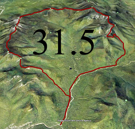
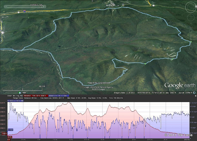
i'm planning on making a vinyl sticker similar to the 26.2 stickers marathoners have for the pemi loop. Whats the general consesus of what mileage i should use? should i include galehead and west bond or not? or just go with standard loop? input please?
 
I have added this to my "goal list" for 2014 so I'd be curious what the "official route" is for this from those that have accomplished. I assume it means leaving Franconia parking area, heading up Osseo and coming all the way back on Bondcliff and returning to Franconia parking area. 10 summits in all (not counting Galehead and West Bond)?
 
I've day hiked the loop several times now and Ive hiked a few different versions of it that are considered "The Pemi Loop" so i'm not looking so much for personal info on the hike but instead I'm looking for what the actual milage of what the most recognized version is. For instance, what is the official milage of the recognized FKT version? should my sticker be 31.5 ?
 
Last edited:
I'd go with just PL. If you want to put a mileage underneath just use 50KM; it's close enough.
 
I like the 50 KM idea. My point from two failed attempts, is that you should include West Bond & Galehead. They don't require much effort. In my case they both ended at Galehead.

5/2006 Franconia's Garfield & Galehead, the idea of going up S Twin & when I would get out vs. the escape down Twin Brook before dark was a clincher, Had never been on Twin Brook before then. In Sept 2006, did Bonds, South Twin, opted for N. Twin and decided I really did not want to do Garfield Ridge, my least favorite trail in the Whites so I stopped at the hut, did Galehead again and then exited Via Twin Brook again. I probably should have pushed to Franconia Brook trail as it's the only one in the area beside Black Pond I have not done.

I would have asked, do you include North Twin too. I suspect many will say yes to West Bond and Galehead, no for North Twin. (Similar to Jackson for a Presi-Traverse. Jackson named for a Cartographer not the President.)
 
I am far from an expert on this, having done it exactly once, but... IMO, "Pemi Loop" suggests it is a loop :) Going to Galehead, West Bond and (especially) North Twin makes it far less of a loop.

Mike P - although West Bond and Galehead don't add "much", 31.5 miles / 50K is plenty of fun for one day and in all honesty, climbing South Twin w/o Galehead was difficult enough for me to be happy I skipped it/them. Maybe as a multi-day trip one could / should add them.

Tim

Galehead doesn't offer much of a view (unless on top of feet of snow...) but West Bond is one of the best peaks IMO (and some others also) providing a unique view of Bondcliff. Whether it's included or not isn't important but it should be a hiking crime (or too foggy to see) to skip it.
 
"PL" is already taken.

Those oval stickers started as a way to identify the country of origin of a car. It was a U.N. proposal but mostly popular in Europe, where it was often difficult to tell what country issued a license plate. (This is changing; the EU has brought standardized license plates that include a country code). F for France, D for Deutschland, E for Espana, IRL for Ireland (with a shadowy green "E" for Eire added later)... PL for Poland.

http://en.wikipedia.org/wiki/List_of_international_vehicle_registration_codes
 
PEMI alone could work. The surrounding oval would be the loop.

Also, ‘‘Franconia’’ parking lot? Do you mean Lincoln Woods? Although I suppose you could start anywhere you wanted. Lincoln Woods is just the one place where you wouldn’t have to do much climbing to reach the course.
 
Last edited:
If you want to get fancy, then make the top of 'PEMI' reflect the ridge lines for the entire route. The P would be Flume to Liberty, Little haystack. The E would be Lafayette Garfield. The M would be South Twin to Bone, and the I would be Bondcliff and then the long walk out. You could also make the outside of the oval itself reflect the ridge. It would be enough to give 'PEMI' some context, IMO.
 
Also, ‘‘Franconia’’ parking lot? Do you mean Lincoln Woods? Although I suppose you could start anywhere you wanted. Lincoln Woods is just the one place where you wouldn’t have to do much climbing to reach the course.

Yah I meant Lincoln on the Kanc. I really shouldn't go on VFTT website on football days. I rarely pay attention with all the distractions. :)
 
Suggestions:
- drop the metric.....nobody uses metric in Pemi Loop context
- don't overexplain it.....make people think
- obviously don't use the google earth map below, that's just to spark your imagination
- forget the spurs,...stick to the basic loop...spurs are a can of worms


PemiLoop-M.jpg
 
If I can get myself ready for it, I may attempt it from either Gale River or Falling Waters. While ending on a descent of Bondcliff and the long slog out, the willing myself over the Garfield Ridge Trail or South Twin after a long hike was problematic. By going up Falling Waters, I'd still have gas in the tank up South Twin I've found the Osseo Trail to be pleasant. (It's probably just mental but hey, we hike our own hikes.) I'm pretty sure I'd be more willing to climb to the Ridge that way then Do the Bonds, South Twin and then have the Garfield Ridge Trail in front of me before reaching Lafayette. I really like the other trails. (I like Garfield too, just not the Ridge Trail)
 
Suggestions:
- drop the metric.....nobody uses metric in Pemi Loop context
- don't overexplain it.....make people think
- obviously don't use the google earth map below, that's just to spark your imagination
- forget the spurs,...stick to the basic loop...spurs are a can of worms


PemiLoop-M.jpg
I really like a lot of this concept. I work with GIS for a profession so I could probably filter out layers of tracks and topo profile, and make a cool design with photoshop

Haha, or maybe if I let this thread go long enough someone will just do all the design work for me.:)
 
Top