Bridge Status In Pemi Wilderness

vftt.org

Help Support vftt.org:

This site may earn a commission from merchant affiliate links, including eBay, Amazon, and others.

DayTrip

Well-known member
Joined
May 13, 2013
Messages
3,710
Reaction score
125
I was plotting some rainy day loop hikes through various parts of Pemi Wilderness area and I'm curious if there are any updates to the various bridge issues mentioned in AMC Guide. My copy (I believe the most recent) mentions issues from 2011 and Irene for several trails and to check with WMNF for details.

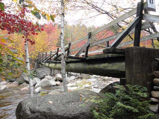
In particular, I'm wondering if the suspension bridge listed as damaged on Thoreau Pond Trail (or was it Shoal Pond Trail?) is still there and still usable? Guide mentioned it had partial damage and had signs indicating one hiker at a time could still use. Is there a WMNF site for these things similar to the Road Status page they maintain for roads? And if it is gone or not usable does anyone know how difficult the crossing is there? I think Guide said bridge was 60' long.

Also, I know this was covered in a previous thread but I'm wondering how crossable the Pemi is at the spot where the old closed section of Wilderness Trail crossed on the bridge that was removed. I remember several people indicating it was doable but I'm curious exactly how low the water needs to be (i.e. if someone has correlated this to the USGS River Flow Gage data, such as "the day I did it it was knee deep and gauge was 400 cfs or whatever). And being "closed" means pass at your own risk or if a ranger sees you you'll be getting fined?

I'm plotting some fairly long loops through this area and these are some pretty remote places to run into issues requiring a turn around or substantial bushwhack along river. If anyone has any feedback it would be appreciated. Thanks.
 
Cant comment about the bridges, but rarely it there an issue in the pemi during summer or early fall to cross rivers unless there is or has been heavy rain in the last 12 hours. The rivers and streams crank up fast but they also drop down quickly. Most are shallow with plenty of rocks and gravel bars. With some minimal scouting its rare that its an issue. This assumes you are willing to wade and there is a lot to be said to bring some tevas to protect your feet when crossing.
 
Shoal Pond has no bridge and usually requires wading near the actual trail crossing.

Thoreau Falls bridge was damaged but usable last November with a weight limit of 1 person (which is exactly what I weigh!).

Never forded the Pemi downstream of the Shoal Pond trail, so I am not sure, but I heard there are stepping stones near the Franconia Brook tributary.
 
Last edited:
I've crossed the Pemi at the wilderness boundary and at the site of the former suspension bridge. I would equate those crossings to being a little more difficult than crossing the Wild River near the old Spider Bridge site. Wait for a stretch of dry days in the summer because even if the Pemi looks "easy" to cross, the pools are deeper than you think. I figured I would only get shin-deep wet mid-summer but ended up sinking above my knees almost to thigh-deep. But, depends on where you cross. Some people get lucky when they pick their crossing and post online, "Crossing was easy!" I haven't found easy to ever be the case....
 
From September 2012 (a year after Irene):
bridge2.jpg

The crossing at the removed bridge
The group in the photo (fortunately no one was named Mary Jo) had old maps and didn't know that a few bureaucrats in the Forest Service had ripped down a historic bridge in record time three years earlier. After 10 minutes of attempts, they hadn't found a way to cross.

bridge3.jpg

The remaining bridge, awaiting a future bureaucrat trying to make a name for themself
 
Philip Werner's scouting trip of the East Branch is here. His conclusion was that it is very difficult to cross the East Branch below the Thoreau Falls bridge. I've been at the alleged crossing at Franconia Brook (next to the Franconia Brook East Tentsite/Wilderness boundary) multiple times, and it has always been way too high to be practical - it would have easily been a mid-thigh or deeper wade in fast water. You would need the right combination of a dry spell and warm weather to even try it.
 
I did the crossing last summer when the Lincoln Woods trail was closed. I crossed immediately north of where the brook from Franconia Falls joins the main stream. I was about knee deep.
 
I did the crossing last summer when the Lincoln Woods trail was closed. I crossed immediately north of where the brook from Franconia Falls joins the main stream. I was about knee deep.

I was there two years ago yesterday and today, camped at the campsite overnight, and assessed the crossing just upstream from Franconia Brook. Looked waist high in places and medium paced. I had hoped to cross and see Franconia Falls and maybe Black Pond in the evening and opted to take a pass.
 
Philip Werner's scouting trip of the East Branch is here. His conclusion was that it is very difficult to cross the East Branch below the Thoreau Falls bridge. I've been at the alleged crossing at Franconia Brook (next to the Franconia Brook East Tentsite/Wilderness boundary) multiple times, and it has always been way too high to be practical - it would have easily been a mid-thigh or deeper wade in fast water. You would need the right combination of a dry spell and warm weather to even try it.

Phil has a whitewater background, so he is probably more aware of river hazards than the average hiker.

Entrapment
One of the biggest dangers of an unplanned swim in whitewater is entrapment, a general term for getting any body extremity, usually a foot or a leg, caught against the river bottom by the force of the current. Often a person unfamiliar with whitewater will attempt to stand on the river bottom and walk to shore. This is an invitation to get a foot caught in a tapered crack between two rocks or in an undercut ledge. Once the limb is caught, it is held there by the force of the current.

Strainers
Fallen trees and accumulations of debris can form strainers: water flows through but a solid object like a boat or person won’t. A strainer can completely block a narrow river. Strainers are particularly dangerous because they look so innocent. Frequently they are also hard to see, especially when a fallen tree trunk is stripped of branches and partly submerged. Not only trees are dangerous, though: smooth, water-worn boulders pushed down from a side creek can form boulder sieves at low water and trap boats and people or, at high water, form a series of holes.

If I had no tolerance for risk, I would hike out to the LW trailhead and cross the East Branch at the bridge.

Bushwhacking to the North Fork and crossing upstream of its confluence with the East Branch is an alternative {the Molly route}.
 
It appears that Phil did those crossings in early May, when the rivers are still swelled with melt water. It's amazing what a difference a foot of water makes in a stream or river. I believe the rule of thumb advocated by many people for doing Owl's Head via the regular trails is if the USGS Pemi gauge at Lincoln is if it's below 800 then you're fine. Not sure if there is a similar rule for fording the East Branch.

You can tell from that link (I adjusted the dates) that the water steadily goes down as summer approaches to stay generally below that 800 CFS threshold aside from storms. For an extreme comparison, you can check out the charts around Tropical Storm Irene. Talk about crazy - it went from ~600 CFS to almost 30,000 in 5 hours. And the gauge rose from just under 6' to 17.5!
 
IME, 800 CFPS means the FINAL crossing of Lincoln Brook will be doable without major wetting of boots (I.e., Black Pond BW to Lincoln Brook Trail.) I don't think it implies anything about the other two (which I have not done).

Tim
 
I think I could have forded the East Pemi just upstream of the Franconia Brook confluence two years ago, but I didn't like the idea of fording it in the near dark, after visiting Franconia Falls and/or Black Pond, later in the evening. The next morning, my mission was to get back to my car at Lincoln Woods and head over to climb a mountain in another part of the Whites, an all-day hike, so I had no interest in doing a ford at that point.

Here are some pics I took of that spot:

This is the confluence with Franconia Brook from the opposite, SE, side.
562189_4278535764573_808997013_n.jpg


This is from the same spot, just upstream of the previous pic.
250762_4278535924577_1770135158_n.jpg
 
Last edited:
I'm wondering how crossable the Pemi is at the spot where the old closed section of Wilderness Trail crossed on the bridge that was removed.
I still think the safest crossing in the general area is the one I describe in the thread on the Molly Route. It does, however, involve some off-trail.
 
IME, 800 CFPS means the FINAL crossing of Lincoln Brook will be doable without major wetting of boots (I.e., Black Pond BW to Lincoln Brook Trail.) I don't think it implies anything about the other two (which I have not done).

Tim

Last year when I did Owls Head I recall asking about those crossings and Tim mentioned 700cfs as kind of the cut off for the two difficult crossings on the actual Lincoln Brook Trail (not the bushwhack). I believe the day I did it gauge was around 500 cfs and I opted to put my water shoes and wade across. Water was just at or above knee caps for me (I'm 6' 3") in several places but overall it was easy with the water shoes. Probably could have been hopped it I spent some time looking but I just wanted to save the time and cross. Put water shoes on at first crossing and left them on for the 0.4 miles between the two.

On one of the possible loops I would be coming down from Bondcliffs and turning up Wilderness Trail to head back to Thoreau and Shoal Trails. That crossing where the old bridge was seems like it is difficult even in good conditions. Anyone ever bushwhack along the North bank and head East for a better chance?

Thanks everyone for the good info.
 
I have never done the earlier crossings, so I cannot comment on them... I do think a friend once mentioned they did it that way without getting wet and the Pemi, East Branch Lincoln gauge was at 110cfps that day. I have done the third crossing no problem at 700-ish.

Tim
 
Back when the bridge was being taken down Lauky and I went up there to take a look. As you can see from the photo, rock hopping was quite easy at that time. We did get written up by a young ranger for coming to see the demolition although nothing ever came of it.

 
I have never done the earlier crossings, so I cannot comment on them... I do think a friend once mentioned they did it that way without getting wet and the Pemi, East Branch Lincoln gauge was at 110cfps that day. I have done the third crossing no problem at 700-ish.

Tim

And for the record, when I did Owl's head years ago (via the trails) I wasn't savvy enough to look at the gauges. We did it during a dry stretch in August, and we were able to rock-hop everything without issue, but it was very low water. Sadly I lost that book, so I don't have the date to check!
 
N44 07 15.3, W71 30 23.3

Wide, but shallow & slow-moving.

Thanks for that detail. I'm fairly GPS illiterate though. How do I pinpoint that exact location on a map like CalTopo? I typed in the search box on CalTopo and it just gave me the general location in the Pemi Wilderness. Did same thing in my BaseCamp software. How can I show that exact spot?
 
Top