Dry River Cut Off/ Mt Eisenhower Trail / Dry RiverTrail

vftt.org

Help Support vftt.org:

This site may earn a commission from merchant affiliate links, including eBay, Amazon, and others.

DayTrip

Well-known member
Joined
May 13, 2013
Messages
3,704
Reaction score
125
I am planning an alternate loop of the Southern Presidentials to check out the Mt Eisenhower Trail and/or Dry River Trail. Never been in that area. Wondering how tough the river crossings are (especially with recent rains) and also if the trail closings in that valley from Irene extend that far up or if that just relates to lower sections (or if they are even still in effect). If anyone has been out there recently I'd appreciate any updates. Thanks.
 
I personally have never had the privilege of hiking the Dry River Trail pre-Irene, but from most reports I've read many parts of that trail are unidentifiable (blowdowns, washouts etc.). Also, I believe the whole trail is closed, but I don't think the side trails (Mt. Clinton, Mt. Eisenhower) are. So you could probably make a loop with those without going onto the actual Dry River Trail. Hope this helped!

PS: If I'm wrong on any of this, please correct me:) .
 
The Dry River Trail is closed.

You can make a wonderful loop using Crawford Path, Mizpah Cutoff, Mt Clinton Trail, Dry River Cutoff, Mt Eisenhower Trail, Mt Eisenhower Loop, Webster Cliff Trail, Crawford Path.

Bring a map for the intersection of Dry River Cutoff/Mt Eisenhower Trail area - even I get turned around in there because the valley of Oakes Gulf throws off any sense of direction. This area is the Bermuda Triangle of the Whites! This is where you will find the only substantial river crossing on the route.

I think the Mt Eisenhower Trail is one of my favorites trails anywhere.

Here's the link to WMNF closures: http://www.fs.usda.gov/detail/whitemountain/home/?cid=stelprdb5371104
 
Last edited:
Bummer. I thought it was just the lower sections of these trails that were closed (below Isolation junction or thereabouts). I guess Mt Eisenhower Trail it is then.
 
I was there last Sunday. Be prepared to travel off trail as the Mt Clinton Tr is difficult to follow. Light use, blowdowns, and encroaching vegetation makes it tough. The trail crosses the brook 7 times as well as a couple tributaries. The sign is missing at the upper junction of the Dry River Cutoff and the entire junction with the Dry River Tr has been washed away. The 2.3 miles of Dry River Tr was easy to follow with flagging around the washouts and one section requires couple hundred yard walk up the river bed. Blowdowns were not a problem on this section. Of course the actual trail is closed so you will need to walk just off to the side. If the Saco River in Bartlett is flowing at 300 cfs or below the crossings on the Dry River should be manageable but still required me to step in an inch or two of water. Remember these trails are in a wilderness are and any blazes are few and far between.

Check the Trail Conditions section on this site or NETC.

http://www.vftt.org/forums/showthre...n-amp-Pierce-with-a-Side-of-Dry-River-6-29-14

http://www.newenglandtrailconditions.com/nh/viewreport.php?entryid=17272

Mt Clinton Tr. These are the "open" sections. It gets much tighter towards the bottom.

20140702_14.JPG


20140702_15.JPG


Missing sections of Dry River Tr. If you zoom in just right of center, you can see a piece of flagging which shows where to reenter the woods.

20140702_21.JPG


20140702_22.JPG


If you are planning to bushwhack you will be pleasantly surprised. If you're planning to follow trails you'll be disappointed and possibly frustrated.
 
Last edited:
Of course the actual trail is closed so you will need to walk just off to the side.
I think if you accidentally take a few steps on the closed Dry River Trail you can just say 10 Hail Marys.
 
I went through officially open segment of Mt Clinton Trail, Dry River Cut Off and Mt Eisenhower Trail. Gotta say I really didn't care for the area. Not very scenic at all with a few small exceptions. The Dry River Cut Off is obviously ironically named because it was nothing but vast stretches of deep mud crossed on slick, rotted log bridges as well as small trees, branches and whatever else fell in the water. Seemed like it took half my life to complete this half mile or so stretch. And as a reward for my efforts I got to crawl under one blow down after another on Mt Eisenhower trail. And I think the trail adopter of the Mt Eisenhower Trail clearly hates tall people because it seemed like I was getting pommeled in the face the entire way up, especially near the top where a really good brushing is needed in spots.

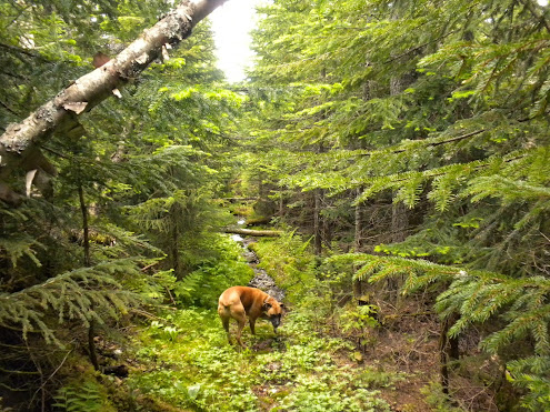
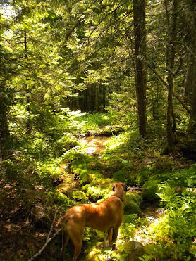
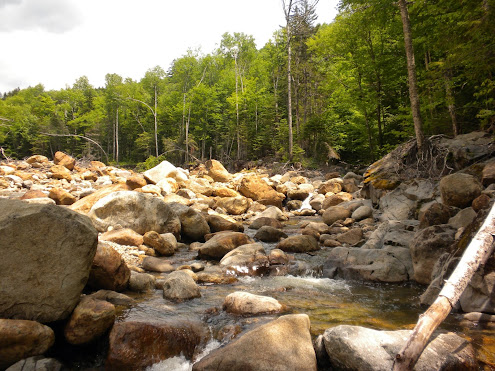
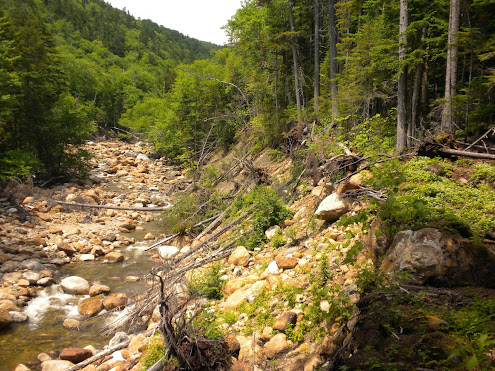
The Dry River was a very large river considering how far up the valley it is. Maybe someday I will return to bushwhack it but it won't be in the near future. It wasn't worth giving up the 1000' of elevation gained at Mizpah Hut to drop into this area and walk back up to the ridge.
 
I think the Mt Eisenhower Trail is one of my favorites trails anywhere.

Really? I found this trail extremely uninteresting until the last 1/4 mile or so as it emerges from trees onto ridge. I didn't find the woods along this trail very scenic at all. Valley had a dead feel to it, I presume from the harsh winters it endures. Is it the remoteness that you find appealing? I wasn't shocked that I didn't see another soul on this entire stretch.
 
Really? I found this trail extremely uninteresting until the last 1/4 mile or so as it emerges from trees onto ridge. I didn't find the woods along this trail very scenic at all. Valley had a dead feel to it, I presume from the harsh winters it endures. Is it the remoteness that you find appealing? I wasn't shocked that I didn't see another soul on this entire stretch.

It all depends on what you're looking for. There is quite a variety of people in the woods who are out for quite a variety of purposes.
 
Sorry to hear of your disappointment. If you had followed the Mt Clinton Tr all the way down to the Dry River the Dry River Cutoff would bring tears of joy to your eyes and feel like the Crawford Path. If solitude is what you seek it can be found in this area.
 
My original plan was to go over to Dry River Trail and follow up to Lakes Of The Clouds before I found out entire trail was closed. Thought it was just closed below this area like Rocky Branch is. Not knowing what kind of problems I would encounter I opted to stay on the open portions of trail. Your pictures of the area are quite nice. I may venture in there down the road and try my hand at bushwhacking. I do love trails that follow rivers.
 
Really? I found this trail extremely uninteresting until the last 1/4 mile or so as it emerges from trees onto ridge. I didn't find the woods along this trail very scenic at all. Valley had a dead feel to it, I presume from the harsh winters it endures. Is it the remoteness that you find appealing? I wasn't shocked that I didn't see another soul on this entire stretch.

Oh, yes! A quiet remote verdant forest without human traffic is pure heaven to me! The Mt. Eisenhower Trail is a treasure to me, as is the Dry River Cutoff.

I try to plan my routes so I don't see other people. Weird stuff, like across the Sandwich Range (Piper Trail/Beeline/Lawrence/Walden/Rollins/Sleeper/Tripyramids), around Carrigain (Carrigain Notch Tr/Wilderness/Cedar Brook/Hancock Notch Tr), Carter-Moriah-Royce-face (East Branch Tr/Wild River/Shelburne Tr)... 3-day weekend-long trails with no one on them = bliss!
 
I think the loss of the Dry River trail is a shame. Ive gone in that way and camped along the river to do Isolation. That river is full of native trout and We would eat them for dinner and breakfast, along with some rice. Its a great valley teaming with wildlife. For those that may never get to do it, its a shame. The river itself can be hairy and I imagine reconstucting the trail would be epic, but maybe some day they will bring it back.
 
Top