MtnManJohn
New member
The New Hampshire Fish and Game Dept is asking people to be on the lookout for a missing hiker
http://www.wildlife.state.nh.us/newsroom/news.html?news=213
http://www.wildlife.state.nh.us/newsroom/news.html?news=213

She would have likely stopped at Galehead Hut both out and back -- surely someone saw her there. Hope she is found soon, thankfully the weather has been good!
Garfield trail to Bondcliff and back in five nights? Either she spent three nights camping at Guyot, or the description of her itinerary is incomplete. Maybe she planned to 'whack down Hellgate brook and loop to 13 Falls, for example. That would make her considerably harder to find.
(F&G is surely not giving us all the details they know. Did she drive herself to the trailhead? Is her car still there?)

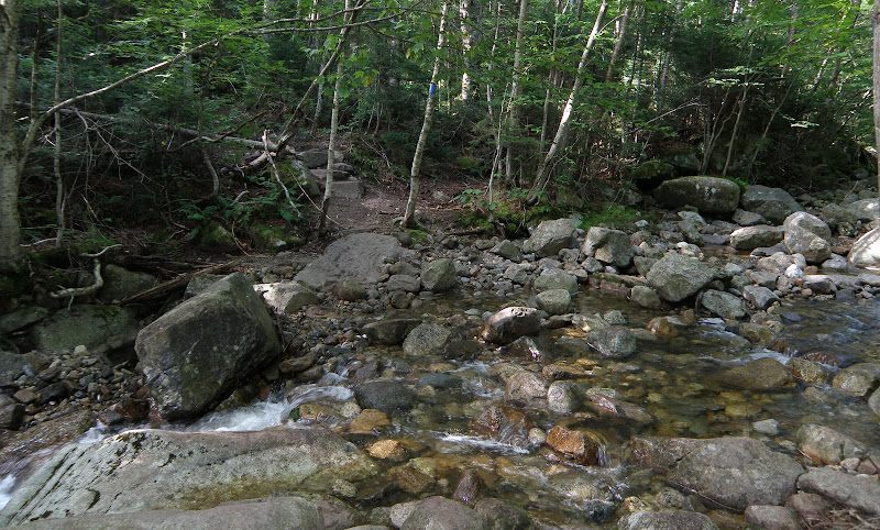
Tragic. My heart goes out to her family. Since the dates in the different stories are different, there's no telling what day she may have made that crossing. The heavy rain was on the 9th I believe. This is the crossing of Garfield Stream at the end of the re-route. It dumps into the Gale River about 500' from this crossing. A gentle flow here but I can see it getting real bad there after a heavy rain. Coupled with a pack weight for 5 nights. Very tragic.
I'm confused about the location: the reroute of 2011 eliminated the (2 big) crossings of the Gale River. Of course, the old trail (if followed) *does* cross it twice. The Garfield Stream (at 2.2 miles up the trail) is fairly minor - a rock-hop with (as I recall) no large pools. I was on the Gale River Trail (the re-routed, current trail) last Saturday and cannot figure out where this happened. Hopefully more info will be forthcoming to help prevent similar situations.
Enter your email address to join: