White Mountains on 1776 New England Map

vftt.org

Help Support vftt.org:

This site may earn a commission from merchant affiliate links, including eBay, Amazon, and others.

SpencerVT

Member
Joined
May 26, 2015
Messages
408
Reaction score
20
Location
Brattleboro, Vermont
I am a huge nerd for old maps and I spend a lot of time pouring over historic maps, particularly of the Northeast.
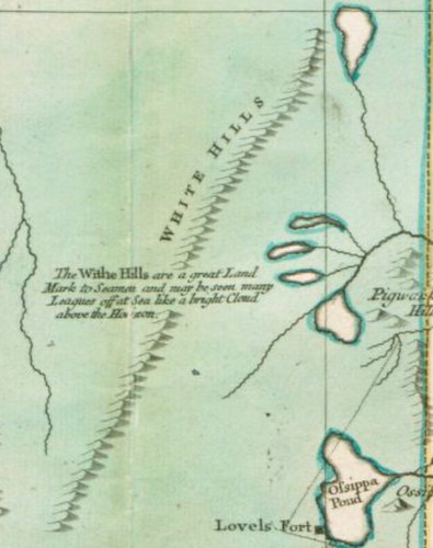
This is from the Tobias Lotter map of 1776, which is considered a remarkable early map of New England.
I found it really fascinating that the caption for the White Mountains is:
White Hills. "The Withe Hills are a great land mark to seaman and may be seen many leagues off at sea like a bright cloud above the horizon."

I would love to know what of the White Mountains can be seen from the Atlantic Ocean on a boat. I found this really cool and interesting.

51996621327_3aa3151fcb.jpg
 
Here is random image I found out on the web

https://maineimaging.smugmug.com/Ae...tland-S-Portland-and-Cape-Elizabeth/i-ThXJ3hX No doubt lenses are involved.

That said the view can be quite spectacular and similar to the profile in the photo on the "right days" from Maine Medical Center on the Western Promenade in Portland. That photo is probably taken from one of the inner islands in Portland Harbor, probably Great Diamond Island or Peaks. Its best in the spring as in the summer the Coast tends to get photochemical smog running up along the New England coast.

The odd part is seeing the ocean from the summit of Mt Washington is a rarer occasion. Scudders Viewing Guide has a short section on when the best times are to see the ocean. The sun has to be just at the correct angle or the ocean just blends into the horizon,
 
Wow. That's really cool. I had no idea it could be seen like that from Portland. It's easy to forget that the way the Maine coastline kinda cuts-in makes Portland spatially not all that far from Mount Washington,
especially since I never drive to the Whites that way.
Thanks for posting that. Totally explains why they would be named the White Mountains by early colonists. Also makes sense why they initially thought Mount Washington was 10,000 feet in elevation.
 
I grew up in Portland. Its about 60 miles from Portland to North Conway via the shortest route. Its actually faster to get to the eastern whites by flying into Portland than Manchester. The trade off is its just state highways from Portland to Conway and they can get clogged up with summer time tourist traffic. On the East Coast I would be hardpressed to come up with a shorter drive from the ocean to significant mountains.
 
I grew up in Portland. Its about 60 miles from Portland to North Conway via the shortest route. Its actually faster to get to the eastern whites by flying into Portland than Manchester. The trade off is its just state highways from Portland to Conway and they can get clogged up with summer time tourist traffic. On the East Coast I would be hardpressed to come up with a shorter drive from the ocean to significant mountains.

Camden harbor to Mt. Megunticook.:):):)
 
I grew up in Portland..... On the East Coast I would be hardpressed to come up with a shorter drive from the ocean to significant mountains.

That photo is cool but I think a looong lens was used to create it. The massif does not look as close or nearly as large from the Portland with the naked eye.
 
I've seen it from a parking garage in Portland, (because I was the doubter back then) and while I was surprised that from Portland it's quite visible, I'm thinking those pics are altered/cropped/photoshopped. The view is great from Kearsarge North and it's much closer and it doesn't look like this.
 
That view was essentially what my mom looked at while at MMC in Portland. And, yes, it's not that close but you can see it very clearly from there.
 
No doubt it was a magnified image (I speculated it was with my reference to "lenses") but on the right day the whites profile is quite distinct. If you envision where the sun is and whites are relative to Porland there are times of the day where the sun is directly lighting the profile of the mountains from behind the viewer in Portland.
 
Last edited:
I also like this 'trick' when photographing people in the foreground of a mountain landscape. Makes it look like whatever is in the background is right over the hiker's shoulder, even if it's distant. My wife and I did this years ago for our Christmas card when we'd visited Denali NP the prior summer. I set up the SLR with (I think) a 300 mm lens, zoomed all the way in on us, and the mountain in the background, the one day we could actually see the mountain. Made it look like the Denali massif was right on top of us!
 
Interesting question, I guess real life. I have never taken a photography course but I know that my generic outdoor "view" shots never approximate the view that I mentally have when standing at a view point looking at a mountain. The camera image inevitably looks far flatter and distant than what my mental view is. So is the moon illusion responsible for my visual perception of the view?. Same question with the profile of the whites in Portland, on a clear day is the moon illusion making my perception of the profile of the whites larger in my mind than is actually there?. So is photography with lenses being used to try to approximate the moon illusion?
 
The key factor in the moon illusion is the location of the moon in the sky--it appears larger when it is close to the horizon than when it is high in the sky. It's a perceptual illusion rather than being caused by the lens FL.

Doug
 
Interesting question, I guess real life. I have never taken a photography course but I know that my generic outdoor "view" shots never approximate the view that I mentally have when standing at a view point looking at a mountain. The camera image inevitably looks far flatter and distant than what my mental view is. So is the moon illusion responsible for my visual perception of the view?. Same question with the profile of the whites in Portland, on a clear day is the moon illusion making my perception of the profile of the whites larger in my mind than is actually there?. So is photography with lenses being used to try to approximate the moon illusion?

The Moon Illusion is a neurological perception.
https://www.scientificamerican.com/...n the moon is near,the moon appear very large.

Where as a photographic image is dependent on the focal length of your lens.
https://www.michaelfrye.com/2015/03/29/lenses-perspective/

Therefore what you are perceiving with your own eyes is not what is being seen through the eye of the camera. Although in both cases the perception is dictated by the lay of the land relative to foreground, midground and background.

All zoom lenses especially will create many different aberrations. The quality of construction of a zoom lens can greatly vary therefore resulting in varying results. The lens can also be affected by the intensity of the light at different points in the image. Light intensity falling in the foreground vs the background can vary the ability of the lens to focus equally across the entire picture.
 
Last edited:
Top