
On Saturday, we all drove up to Millinocket and ate dinner and spent the night at Ruthie's. Decent food, decent prices, clean, if dated, accomodations. I can recommend the fried smelt dinner. Between our arrival and dinner, we had some time to kill, so we drove the pothole highway a/k/a The Golden Road to Abol Bridge to preview the parking situation and judge conditions for skiing. We were treated to some blue sky views followed by some alpine glow while there. The long-range forecast suggested that Tuesday would be the better of the two summit days we had baked into our schedule.
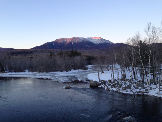
Preview of Katahdin from Abol Bridge over West Branch Penobscot River
After breakfast on Sunday, we drove the pothole highway again, parking in the standard place, and carrying our sleds and skis over the pavement and ice until we found snow on the trail. It took us 5.5 hours or so to traverse the Abol Trail, Tote Road, and Roaring Brook Road, arriving at the Roaring Brook Bunkhouse around 3PM. There were two ice climbers on the way as well, and we shared the space and dinner time conversations with them. As he did every day, Ranger Greg showed up late afternoon to see what plans people had, check the paperwork, and give us the weather forecast. At this point, it seemed like Tuesday was still the summit day as Monday was forecast to snow an inch with higher winds.
Bottom of Katahdin visible over Helon Taylor Pond
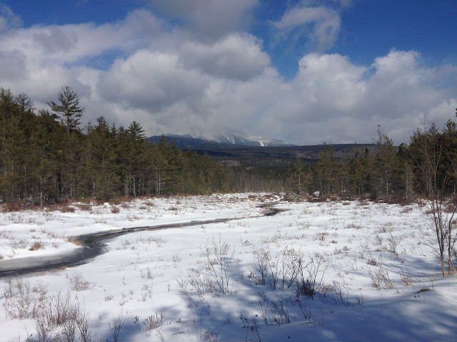
When we got up Monday, it was still clear out and rather than remain cooped up in the bunkhouse, we explored the Sandy Stream Pond area and headed up South Turner. Part way up, the snow started falling and at treeline, it was blowing fairly hard and snowing harder so we took like 1 picture and booked it back down to the trees. There was close to three feet of snow in places (like on the bridges over the streams), and it looked like nobody had been there in a while as we sunk 12-18" in places even in snowshoes.
View from Fisherman's Rock on Sandy Stream Pond
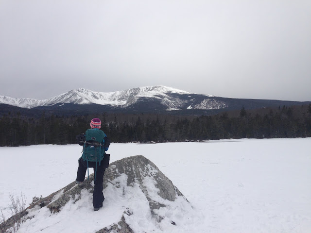
Shortly after our return, three new bunkmates appeared. I had been contacted by one of them in advance. They planned to spend one night at Roaring Brook and then go on to lean-tos at Chimney Pond. On schedule, Ranger Greg appeared, with the forecast - confirming Tuesday was the only likely summit day of the next three. He also informed us that the 4 inches (not 1) at Roaring Brook was more like 6-8" at Chimney Pond. Given the likelyhood of avalanches, the recommended route was out-and-back via Hamlin Ridge. After some discussion, the new bunkmates decided to accept the offer of a lean-to at Roaring Brook so they could make a summit push with or behind us on Tuesday, allowing one of them to complete the NEHH in winter. Jason would also be finishing a single-season winter 67 and George his Winter 115.
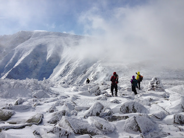
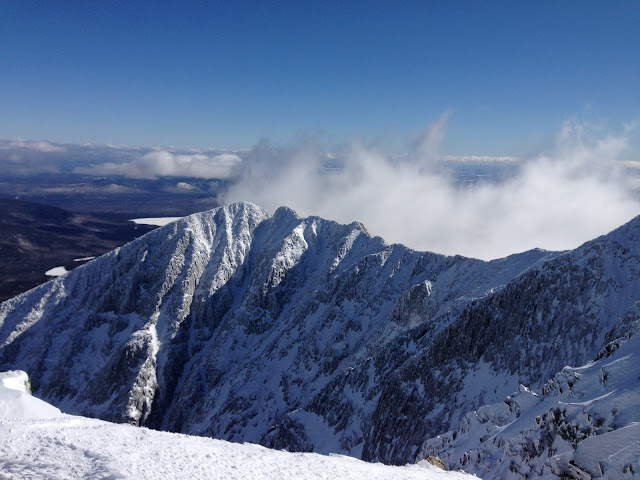
Pamola, Chimney, Knife Edge, South Peak and Baxter Peak materializing from the clouds
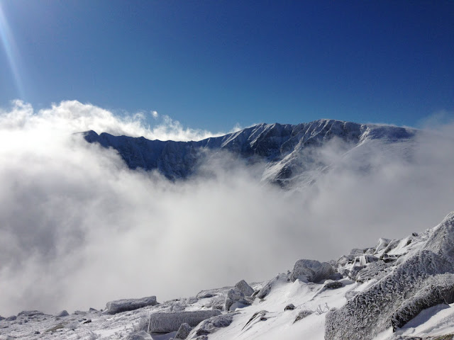
Tuesday AM the 9 of us set out for the 13-mile, 6600-foot trip by headlamp at 05:00. By the time we reached the Northwest Basin Trail, we found that the predicted inch from Monday had indeed turned into a trail breaking affair, albeit not a very long one to treeline on Hamlin Ridge. Along the ridge itself, Baxter Peak appeared and disappeared as the clouds slowly made their way out. Once well above the trees, the snowshoes and poles were stowed and replaced by crampons and ice axes.
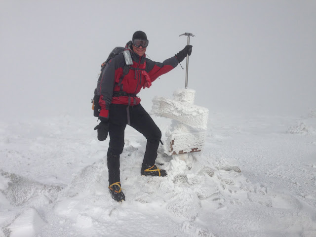
Me on Hamlin Peak
Hamlin was largely in the clouds for our early crossing, providing limited views of the surrounding landscapes, complete with cornices, ice, and steep snowfields leading into the north basin. Bundled up and goggled up, we turned into the wind and descended into the Saddle Col.
Approaching The Saddle
On the way down, the clouds moved high enough to give us dramatic views of Baxter Peak, the ponds below the basins, and North and South Turner. Everything to the west (Brothers, Fort, Coe) was completely covered up. I probably took 1/3 of the photos for today between the two peaks, with the remaining ones from the summit of Baxter.
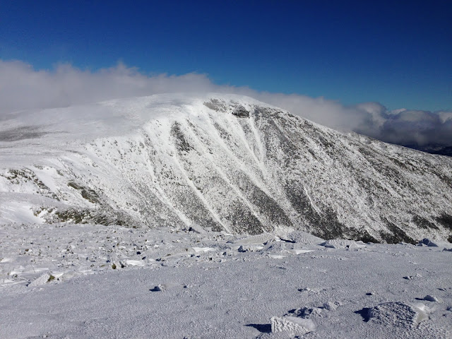
Looking back to Hamlin
We did peer down the Saddle Trail and agreed it was a good idea to skip it, and a good idea to not use it even in a bail-out scenario. With the weather conditions we had, as long as nobody got hurt, a bail-out seemed very unlikely. We did see the other party of three summit Hamlin Peak and being their descent while we were approaching Baxter. We also spotted the two ice climbers from the first night - they bailed out on Cilley-Barber, opting instead to simul-climb the Cathedral Trail and cross the Knife Edge and descend the Dudley Trail. They waved")
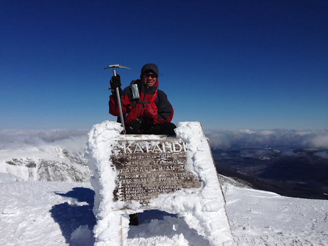
Me on Baxter Peak
Ranger Greg told us that about 1/3 of the people who plan to climb Katahdin actually make it. We were privileged enough to enjoy a dramatic sky combined with temps and wind speeds in the upper 20s. This allowed us to enjoy the summit by ourselves for almost 30 minutes. Some ventured part way to South Peak, others enjoyed the views, and Jason and George celebrated their winter accomplishments. Jason was kind enough to make a NEHH Winter sign for the other party on the back of his SSW 67 sign, and gave it to them in passing on our way down.
South Peak
As we returned to Hamlin, we congratulated our bunkhouse mates on their winter accomplishments and then spent another 30 minutes sunbathing, eating, hydrating and talking in the Saddle Col, before re-climbing the now-sunny Hamlin Peak. Good buttsliding got us back down to the Chimney Pond trail where we decided to pay Ranger Greg a visit and enjoy the view from the bottom, so-to-speak.
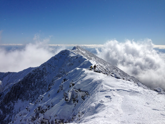
Knife Edge
All in all, this was the best winter hiking/mountaineering experience of my life. I will say that the Zealand Road road walk pales in comparison to Roaring Brook Road and Tote Road walks, at least in terms of distance. These two have a bit better views of ponds and a higher likelyhood of wildlife (we saw loads of deer and fresh moose tracks, but no actual moose).
All Pictures
Tim
Preview of Katahdin from Abol Bridge over West Branch Penobscot River
After breakfast on Sunday, we drove the pothole highway again, parking in the standard place, and carrying our sleds and skis over the pavement and ice until we found snow on the trail. It took us 5.5 hours or so to traverse the Abol Trail, Tote Road, and Roaring Brook Road, arriving at the Roaring Brook Bunkhouse around 3PM. There were two ice climbers on the way as well, and we shared the space and dinner time conversations with them. As he did every day, Ranger Greg showed up late afternoon to see what plans people had, check the paperwork, and give us the weather forecast. At this point, it seemed like Tuesday was still the summit day as Monday was forecast to snow an inch with higher winds.
Bottom of Katahdin visible over Helon Taylor Pond
When we got up Monday, it was still clear out and rather than remain cooped up in the bunkhouse, we explored the Sandy Stream Pond area and headed up South Turner. Part way up, the snow started falling and at treeline, it was blowing fairly hard and snowing harder so we took like 1 picture and booked it back down to the trees. There was close to three feet of snow in places (like on the bridges over the streams), and it looked like nobody had been there in a while as we sunk 12-18" in places even in snowshoes.
View from Fisherman's Rock on Sandy Stream Pond
Shortly after our return, three new bunkmates appeared. I had been contacted by one of them in advance. They planned to spend one night at Roaring Brook and then go on to lean-tos at Chimney Pond. On schedule, Ranger Greg appeared, with the forecast - confirming Tuesday was the only likely summit day of the next three. He also informed us that the 4 inches (not 1) at Roaring Brook was more like 6-8" at Chimney Pond. Given the likelyhood of avalanches, the recommended route was out-and-back via Hamlin Ridge. After some discussion, the new bunkmates decided to accept the offer of a lean-to at Roaring Brook so they could make a summit push with or behind us on Tuesday, allowing one of them to complete the NEHH in winter. Jason would also be finishing a single-season winter 67 and George his Winter 115.
Pamola, Chimney, Knife Edge, South Peak and Baxter Peak materializing from the clouds
Tuesday AM the 9 of us set out for the 13-mile, 6600-foot trip by headlamp at 05:00. By the time we reached the Northwest Basin Trail, we found that the predicted inch from Monday had indeed turned into a trail breaking affair, albeit not a very long one to treeline on Hamlin Ridge. Along the ridge itself, Baxter Peak appeared and disappeared as the clouds slowly made their way out. Once well above the trees, the snowshoes and poles were stowed and replaced by crampons and ice axes.
Me on Hamlin Peak
Hamlin was largely in the clouds for our early crossing, providing limited views of the surrounding landscapes, complete with cornices, ice, and steep snowfields leading into the north basin. Bundled up and goggled up, we turned into the wind and descended into the Saddle Col.
Approaching The Saddle
On the way down, the clouds moved high enough to give us dramatic views of Baxter Peak, the ponds below the basins, and North and South Turner. Everything to the west (Brothers, Fort, Coe) was completely covered up. I probably took 1/3 of the photos for today between the two peaks, with the remaining ones from the summit of Baxter.
Looking back to Hamlin
We did peer down the Saddle Trail and agreed it was a good idea to skip it, and a good idea to not use it even in a bail-out scenario. With the weather conditions we had, as long as nobody got hurt, a bail-out seemed very unlikely. We did see the other party of three summit Hamlin Peak and being their descent while we were approaching Baxter. We also spotted the two ice climbers from the first night - they bailed out on Cilley-Barber, opting instead to simul-climb the Cathedral Trail and cross the Knife Edge and descend the Dudley Trail. They waved
Me on Baxter Peak
Ranger Greg told us that about 1/3 of the people who plan to climb Katahdin actually make it. We were privileged enough to enjoy a dramatic sky combined with temps and wind speeds in the upper 20s. This allowed us to enjoy the summit by ourselves for almost 30 minutes. Some ventured part way to South Peak, others enjoyed the views, and Jason and George celebrated their winter accomplishments. Jason was kind enough to make a NEHH Winter sign for the other party on the back of his SSW 67 sign, and gave it to them in passing on our way down.
South Peak
As we returned to Hamlin, we congratulated our bunkhouse mates on their winter accomplishments and then spent another 30 minutes sunbathing, eating, hydrating and talking in the Saddle Col, before re-climbing the now-sunny Hamlin Peak. Good buttsliding got us back down to the Chimney Pond trail where we decided to pay Ranger Greg a visit and enjoy the view from the bottom, so-to-speak.
Knife Edge
All in all, this was the best winter hiking/mountaineering experience of my life. I will say that the Zealand Road road walk pales in comparison to Roaring Brook Road and Tote Road walks, at least in terms of distance. These two have a bit better views of ponds and a higher likelyhood of wildlife (we saw loads of deer and fresh moose tracks, but no actual moose).
All Pictures
Tim