Mudrat
Member
DISCLAIMER
Specifics:
Date Climbed: 2013 August 10
Mileage/Elevation Gain/Duration: 13 miles/4,250 feet (both slides/exit over Beckhorn)/12 hours
Temperature: 50-70 Fahrenheit
Partners: Nangaparbat
Route: Elk Lake trailhead to Beckhorn Trail – Bushwhack from 3,100 feet elevation to slide – Slide - Exit to ridge and back over Beckhorn.
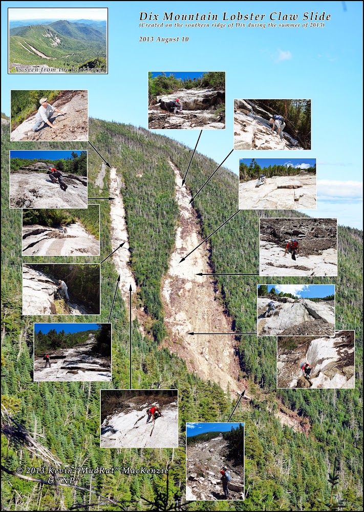
Slide (from northern runout bottom) Elevation/Length: about 950 feet/3,000 ground feet
Benchmarks: Begin: 8:10 a.m., Begin Bushwhack: 10:50 a.m., Slide runout: 12:00 p.m., Top of North Run: 2:20 p.m., Top of South Run: 3:15 p.m.; Finish Hike: 8:00 p.m.
Pictures
Video:
Intro/Thoughts
I topped Santanoni’s East (Twin) Slide on Monday, August 5th. While scanning to the east something seemed amiss in the panorama. Two white scars, partially hidden behind one of Dix’ western ridges, painted what looked like the side of the southern ridge (between the Beckhorn and Hough). I pushed it to the back of my mind at first. The next day, I grew curious and scanned a few photos from trip reports on the forum. Comparing June and July photos from Hough confirmed that Dix had a new slide added to its already extensive collection. Time to explore!
Few things in life are more completely satisfying than exploring a wilderness unknown, especially if it’s newly created. Irene created vast amounts of new territory to play upon. This new creation on Dix reinvigorated the excitement I felt nearly two years ago when I was in the backcountry. This time, I didn’t have as much information ahead of time…no aerial photos or easily accessed line-of-sight vantage points. It stoked my curiosity to a feverish level.
There isn’t any satellite imagery on these slides yet, but they (not surprisingly) followed along the same course as ancient slides that had regrown with mature forest. As a point of reference based on currently available satellite imagery, the release point for the northern run began between two 15 foot runs of old-exposure ledges at roughly 4,220 in elevation. The ledges are clearly visible on flashearth.
Parking and the Approach
I arrived at the Elk Lake parking lot around 7:00 a.m.; it was full by 7:10 and NP was still en route. At least a dozen cars looked at the lot only to be turned away in hopes of finding a place miles back down the road before the gate. When NP arrived we got creative and found him a spot.
Fast forward a bit to our arrival at the Beckhorn Trail intersection a bit over four miles from the trailhead. We needed to climb an additional 850 or so feet before beginning what I hoped would be a the path of least resistance to the runout of the slide—wherever that started. I felt a bit under the weather wasn’t really in the mood to navigate the stream confluences leading up into the area.
At 3,100 feet we reached my target where the trail becomes nearly flat atop the ridge. We embarked right on a perpendicular course to the right. I’d never bushwhacked here and looked forward to seeing the area. Rotten blowdown and moderate growth with the occasional glacial erratic seemed to be the rule. The cool rain of the day prior was still on the branches of the trees.
Once on the other side of the ridge, a heading of 62 degrees true (or 76 magnetic) led us on a counterintuitive route on contour along the ridge. This will change slightly depending on how you exit the ridge. I was just guessing at the location of the runout since I didn’t know how far it had torn down the valley. En route, the forest vacillated between loosely knit and enjoyable to more tightly knit sections of balsam. I fought the instinct to descend rather than continue on contour. My heading did, indeed, vary a bit as we worked around obstacles so I looked for visual cues to reaffirm our location. (This became ever more important each time NP reminded me that if we got lost it would be my fault ). The first positive sign was a 10 foot wide stream flowing down from the left. We looked up its streambed and saw the Beckhorn was still far away. …but what a place to relax!
Runout
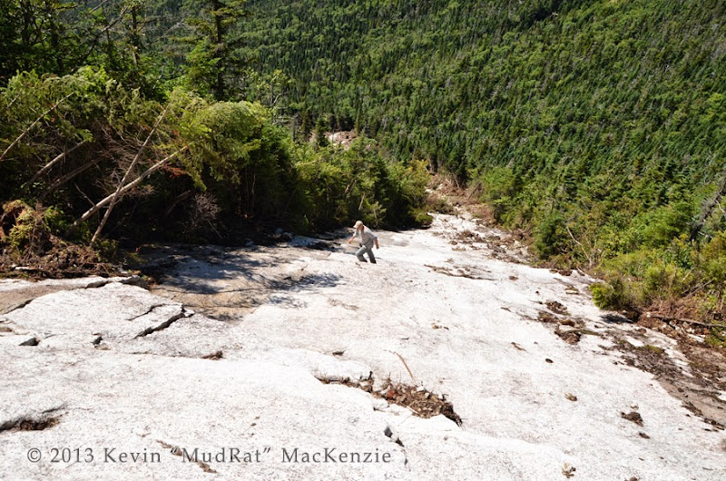
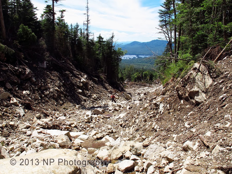
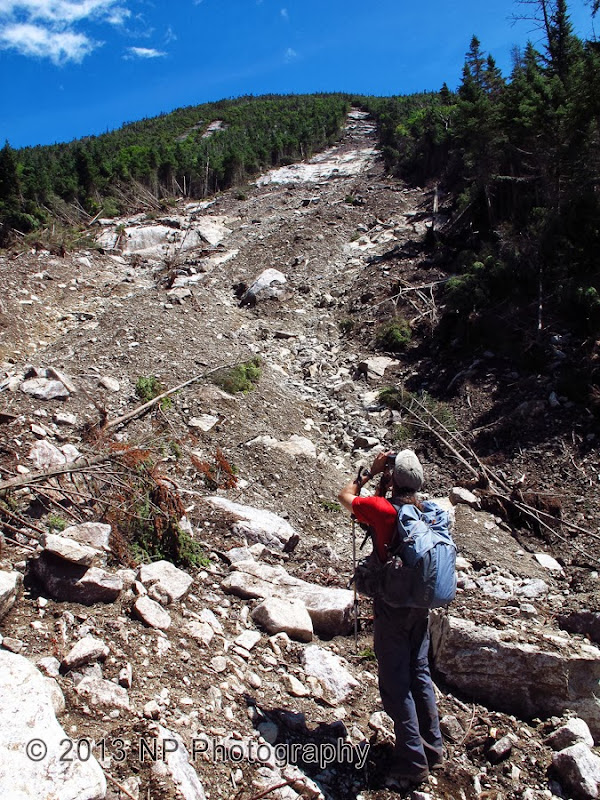
After a bit more bushwhacking, we began to see some slides reflecting brightly in the late morning sun. They were too broad for our target…Hough. I didn’t expect to be quite as close as we were. “C’est la vie.” We needed to readjust in order to climb north of a smaller ridge between Hough and Dix. I changed the bearing to 60 degrees magnetic. Ten minutes later we found a few small snags of mud and pine needles in another small streambed. A bit farther uphill was a narrow toe of rubble. NP’s excitement rose while I kept mine to a dull roar until I was comfortable that we weren’t following the drainage of some minor slide. The bed opened wider with freshly exposed stone all around; this all fit what I’d hoped. Pure luck found us at the first signs of the slide. (Another runout of the same slide set lies a bit farther to the southeast). The bushwhack of a bit over about ½ mile had taken about one hour or four from the trailhead. The time stood at noon.
Kevin walking up the slide...almost there. This is quite the runout!
I found the first item of geological interest just upstream--a stone with what looked like the remnants of a 3” geode with either clear quartz or calcite crystals. Slightly higher, it was all about the views as it widened more and more. To the rear, Elk Lake was framed by the deeply gouged stream bed. We were also on an even elevation with an unabashed view of Hough’s magnificent slides. The best perch seemed to be atop of a 15 foot pile of trees some with their leaves still green, though wilted.
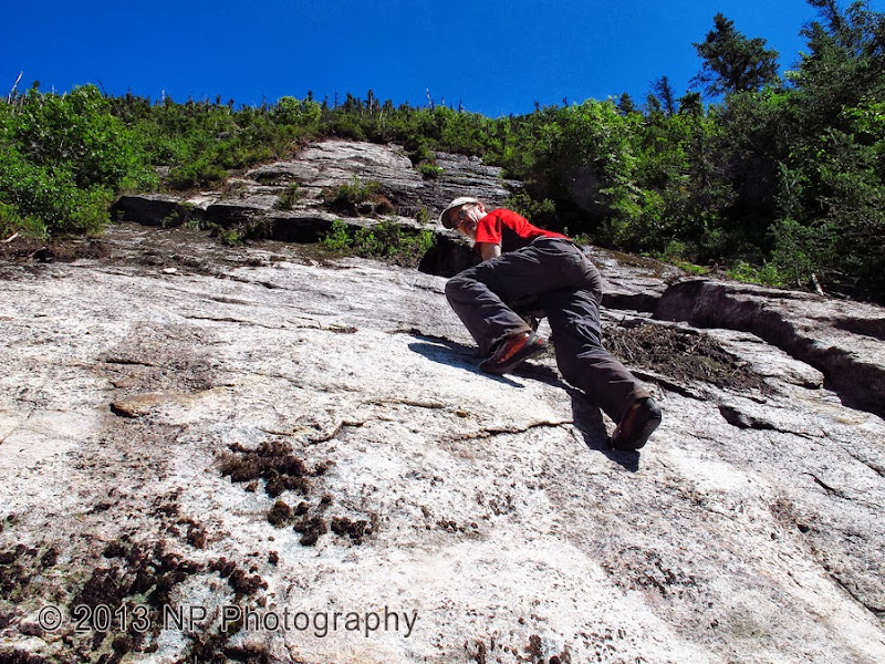
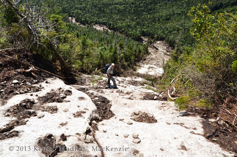
The runout itself became more and more impressive as we ascended. It’s not as long as some from Irene, but the terrain and volume of debris that tore through the area cut a humbling track. Most of it seemed pretty well consolidated, but I was careful of what I tugged and walked on. We were far from help and about 5.5 miles from the trailhead.
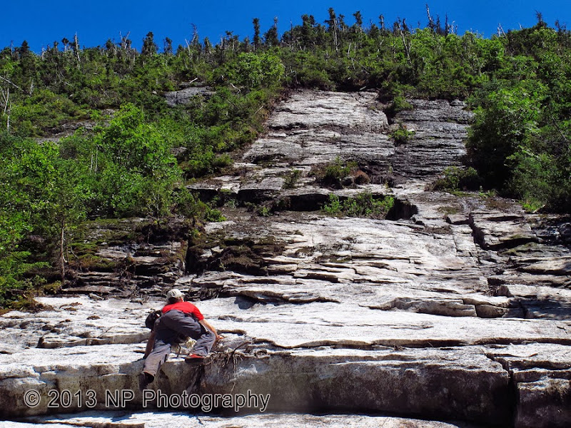
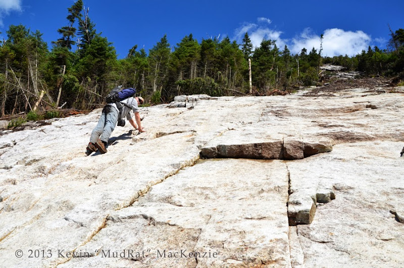
The direction shifted rather sharply around an island of tall softwoods. The relative streambeds from each slide (2) were close enough to each other on either side to obliterate the forest between. After climbing a large rubble pile, a full view up to the top of the southern tributary unfolded. It was expansive, dramatic and simply breathtaking. The first major outcrop of slab under the southern tributary was underfoot at about 3,750 feet in elevation. Scrambling another couple hundred feet of debris, we found a comfortable ledge and took a long break to eat and discuss our climbing strategy.
Kevin looking up the southern run.
Specifics:
Date Climbed: 2013 August 10
Mileage/Elevation Gain/Duration: 13 miles/4,250 feet (both slides/exit over Beckhorn)/12 hours
Temperature: 50-70 Fahrenheit
Partners: Nangaparbat
Route: Elk Lake trailhead to Beckhorn Trail – Bushwhack from 3,100 feet elevation to slide – Slide - Exit to ridge and back over Beckhorn.
Slide (from northern runout bottom) Elevation/Length: about 950 feet/3,000 ground feet
Benchmarks: Begin: 8:10 a.m., Begin Bushwhack: 10:50 a.m., Slide runout: 12:00 p.m., Top of North Run: 2:20 p.m., Top of South Run: 3:15 p.m.; Finish Hike: 8:00 p.m.
Pictures
Video:
Intro/Thoughts
I topped Santanoni’s East (Twin) Slide on Monday, August 5th. While scanning to the east something seemed amiss in the panorama. Two white scars, partially hidden behind one of Dix’ western ridges, painted what looked like the side of the southern ridge (between the Beckhorn and Hough). I pushed it to the back of my mind at first. The next day, I grew curious and scanned a few photos from trip reports on the forum. Comparing June and July photos from Hough confirmed that Dix had a new slide added to its already extensive collection. Time to explore!
Few things in life are more completely satisfying than exploring a wilderness unknown, especially if it’s newly created. Irene created vast amounts of new territory to play upon. This new creation on Dix reinvigorated the excitement I felt nearly two years ago when I was in the backcountry. This time, I didn’t have as much information ahead of time…no aerial photos or easily accessed line-of-sight vantage points. It stoked my curiosity to a feverish level.
There isn’t any satellite imagery on these slides yet, but they (not surprisingly) followed along the same course as ancient slides that had regrown with mature forest. As a point of reference based on currently available satellite imagery, the release point for the northern run began between two 15 foot runs of old-exposure ledges at roughly 4,220 in elevation. The ledges are clearly visible on flashearth.
Parking and the Approach
I arrived at the Elk Lake parking lot around 7:00 a.m.; it was full by 7:10 and NP was still en route. At least a dozen cars looked at the lot only to be turned away in hopes of finding a place miles back down the road before the gate. When NP arrived we got creative and found him a spot.
Fast forward a bit to our arrival at the Beckhorn Trail intersection a bit over four miles from the trailhead. We needed to climb an additional 850 or so feet before beginning what I hoped would be a the path of least resistance to the runout of the slide—wherever that started. I felt a bit under the weather wasn’t really in the mood to navigate the stream confluences leading up into the area.
At 3,100 feet we reached my target where the trail becomes nearly flat atop the ridge. We embarked right on a perpendicular course to the right. I’d never bushwhacked here and looked forward to seeing the area. Rotten blowdown and moderate growth with the occasional glacial erratic seemed to be the rule. The cool rain of the day prior was still on the branches of the trees.
Once on the other side of the ridge, a heading of 62 degrees true (or 76 magnetic) led us on a counterintuitive route on contour along the ridge. This will change slightly depending on how you exit the ridge. I was just guessing at the location of the runout since I didn’t know how far it had torn down the valley. En route, the forest vacillated between loosely knit and enjoyable to more tightly knit sections of balsam. I fought the instinct to descend rather than continue on contour. My heading did, indeed, vary a bit as we worked around obstacles so I looked for visual cues to reaffirm our location. (This became ever more important each time NP reminded me that if we got lost it would be my fault
). The first positive sign was a 10 foot wide stream flowing down from the left. We looked up its streambed and saw the Beckhorn was still far away. …but what a place to relax!Runout
After a bit more bushwhacking, we began to see some slides reflecting brightly in the late morning sun. They were too broad for our target…Hough. I didn’t expect to be quite as close as we were. “C’est la vie.” We needed to readjust in order to climb north of a smaller ridge between Hough and Dix. I changed the bearing to 60 degrees magnetic. Ten minutes later we found a few small snags of mud and pine needles in another small streambed. A bit farther uphill was a narrow toe of rubble. NP’s excitement rose while I kept mine to a dull roar until I was comfortable that we weren’t following the drainage of some minor slide. The bed opened wider with freshly exposed stone all around; this all fit what I’d hoped. Pure luck found us at the first signs of the slide. (Another runout of the same slide set lies a bit farther to the southeast). The bushwhack of a bit over about ½ mile had taken about one hour or four from the trailhead. The time stood at noon.
Kevin walking up the slide...almost there. This is quite the runout!
I found the first item of geological interest just upstream--a stone with what looked like the remnants of a 3” geode with either clear quartz or calcite crystals. Slightly higher, it was all about the views as it widened more and more. To the rear, Elk Lake was framed by the deeply gouged stream bed. We were also on an even elevation with an unabashed view of Hough’s magnificent slides. The best perch seemed to be atop of a 15 foot pile of trees some with their leaves still green, though wilted.
The runout itself became more and more impressive as we ascended. It’s not as long as some from Irene, but the terrain and volume of debris that tore through the area cut a humbling track. Most of it seemed pretty well consolidated, but I was careful of what I tugged and walked on. We were far from help and about 5.5 miles from the trailhead.
The direction shifted rather sharply around an island of tall softwoods. The relative streambeds from each slide (2) were close enough to each other on either side to obliterate the forest between. After climbing a large rubble pile, a full view up to the top of the southern tributary unfolded. It was expansive, dramatic and simply breathtaking. The first major outcrop of slab under the southern tributary was underfoot at about 3,750 feet in elevation. Scrambling another couple hundred feet of debris, we found a comfortable ledge and took a long break to eat and discuss our climbing strategy.
Kevin looking up the southern run.