
Kevin Judy and Emma
Well-known member
7/26/08
Seek the Peak Fundraiser for the MWO
Boott Spur Trail/ Davis Path/ Crawford Path to Mount Washington 6288' Down Tuckerman Ravine Trail
10.8 Miles 4300' Elevation gain
Kevin, Judy and Emma
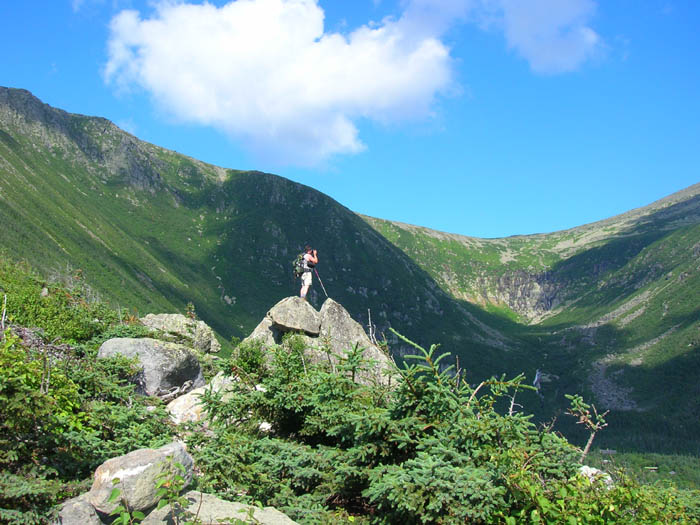
Me at Harvard Rock taken by Jude.
For the seventh consecutive year, Judy, Emma and I have made the hike to the summit of Mount Washington to raise money for the non-profit Mount Washington Observatory (MWO) in their annual Hike-a-thon known as Seek the Peak. Of the various non-profit organizations who are involved in the education of the general populace about life above tree-line in the White Mountains of New Hampshire, we find the MWO to be one of the more informative and giving.
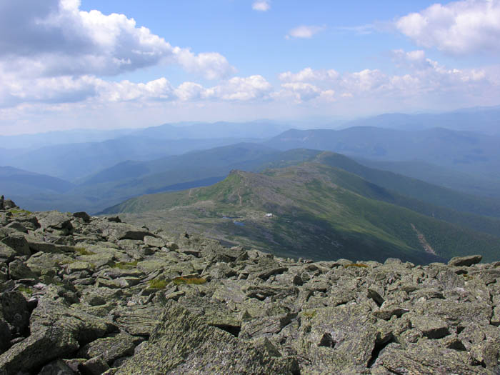
View across to Nelson Crag from Boott Spur Trail
The funds raised at this event go towards keeping an outpost on the top of New England year round in some of the harshest conditions found below the arctic circle. Many who venture forth into the White Mountains benefit from the MWO without giving it a thought. If you have ever checked in at an AMC Hut to see what the weather forecast for the higher summits was, or if it was posted in a motel or campground you were staying at, the report came from the summit of Mount Washington. Sure, we all joke about the inaccuracy of the weather forecasts, but the MWO has been a valuable tool for hikers at all times of the year since before most of us were born.
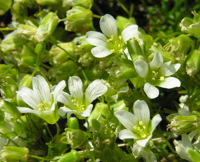
Mountain Sandwort Minaurtia groenlandica
Through their educational programs, known as Edu-trips, many have gotten to experience what the meteorologists do on a daily basis, living on the top of the highest peak in the northeast, year-round. Winter and summer Edu-trips are available, and all sorts of things from weather, to geology to photography are covered on the different trips. I got started and became interested when my wife, Judy, sent me on an Edu-trip in March of '04, as a Christmas present.More can be found out here:
http://www.mountwashington.org/education/
Davis Path near the junction with the Crawford Path
From there my participation has grown into becoming a volunteer cook for the crew. I get to spend a week at a time with them as they go about their various jobs on the summit. I cook and clean and do odd jobs and in return I get to experience some of the most awesome sights I have ever seen. Sunrise or sunset over an undercast sky, full moon over a partial undercast with the lights of the small cities twinkling below, 90mph winds and windchills of 35 below zero. These are just some of the things I have been lucky enough to experience, all in relative comfort. As for the crew I have met few people in my life who are as passionate about their work and who are willing to share their knowledge with any who are willing to ask. Each trip I make is a memory of a lifetime and I have made some great friends in so doing, so helping each year to raise money to keep their operation going is little enough for me to give back in lieu of what I have been given.
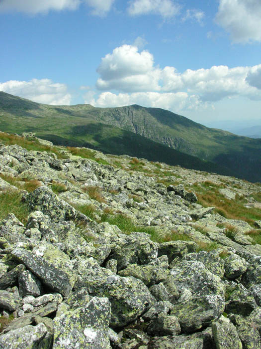
View down to the Lakes of the Clouds from the Crawford Path
I also know that many in the hiking community look with disdain at the summit buildings, the Auto Road, The Cog and wish for a return to a more natural summit. Yes, I have made the climb up Tuck's and nearly been run over in the parking lot, and yes, I have choked on the pungent black smoke of the Cog. I have stood in line trying to get a summit picture while tourists in flip-flops and T-shirts mob the summit sign. I prefer to ignore all the negativity I can conjure up about the summit of Mount Washington and remember the wonderful things that I have learned there and been able to share with others. The MWO is working in partnership with the State Park and believe it or not the summit is becoming a greener place to visit. Power has come up from the valley on private land beside The Cog. Yes, they had to dig an ugly trench and disturb the alpine vegetation to do it, but it got rid of the constant roar of the generators and the noxious diesel fumes they created. They are currently cleaning up along the Cog tracks, removing old railroad ties and trying to restore things to their original state as much as possible. The State Park is working in conjunction with the Forest Service to restore the alpine vegetation. The over-all improvement of the clean-up is obvious while visisting. Future projects will include the removal of some of the tanks from the tank fields just below the summit now that not as much fuel needs to be stored there since the generators became a back-up instead of a main power source. A new, much more enviro-friendly septic system is about to be installed. It has been designed by Lifewater Engineering in Alaska who has enjoyed much success in cold and remote locations. More can be found out here:
http://lifewaterengineering.com/Overview.htm
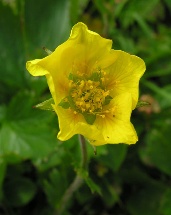
Mountain Avens Geum peckii
And who knows, with the leaps in technology we may soon see the radio towers removed. Now that would be progress! The Cog and Auto Road always have and always will be there, not much can be done about that. In a positive sense they bring many thousands who otherwise would not have a chance to see these things or gain an appreciation for the mountains that they may not otherwise have obtained, and I can't see that as a bad thing!
OK, I'll step down off the grandstand now, at least for a minute. We had great weather for our hike after some sketchy forecasts, (insert meteorologist jokes here). We climbed the Boott Spur Trail, one of our favorites, and made our way across the Bigelow Lawn along the Davis Path to its junction with the Crawford Path on the west flank of the mountain. From here we made the much less crowded hike to the summit, while on the east side the Tuckerman Ravine Trail took on it's weekend pilgrimage appearance. After checking in with many different friends on the summit, we made our way down through the masses along the Tuckerman Ravine Trail. The various waterfalls and loads of wildflowers between The Lip and The Bowl make this one of the most scenic, and one of my favorite parts of this most excellent mountain. Of course, the trail below Hojo's down to Pinkham Notch Visitor Center could be the second boringest hike in the White Mountains, but it goes by quick, and hey, who wouldn't want to be walking in the woods on a fine summer day?
This year there were over 350 hikers besides the usual throngs, hiking to raise money for the MWO. Incredibly, we raised over $97,000, half again what we raised in the record setting fundraiser last July. This is roughly one third the yearly operating cost for the summit observatory, so a great fundraising day, indeed! Emma also had a personal best fundraising year, raising over $1000! We were all treated to music under the Big Top and a turkey dinner "That couldn't be beat" provided by, (no, not Alice), Hart's Turkey Farm. Thank you! Over $40,000 in donated prizes were given out in drawings to the over 350 participants, including a one year lease on a new Subaru.
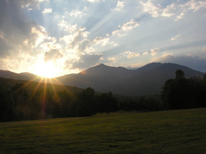
End of day from the Glen House
All in all it was a great event, great day to hike MW, great people and a great time. Thanks to all who donated to Emma's pledge page, and we hope to see you all again next year!
Complete set of pics here:
http://ghostflowers.com/white_mtns4000/washington72608/washington72608.html
KDT
Seek the Peak Fundraiser for the MWO
Boott Spur Trail/ Davis Path/ Crawford Path to Mount Washington 6288' Down Tuckerman Ravine Trail
10.8 Miles 4300' Elevation gain
Kevin, Judy and Emma
Me at Harvard Rock taken by Jude.
For the seventh consecutive year, Judy, Emma and I have made the hike to the summit of Mount Washington to raise money for the non-profit Mount Washington Observatory (MWO) in their annual Hike-a-thon known as Seek the Peak. Of the various non-profit organizations who are involved in the education of the general populace about life above tree-line in the White Mountains of New Hampshire, we find the MWO to be one of the more informative and giving.
View across to Nelson Crag from Boott Spur Trail
The funds raised at this event go towards keeping an outpost on the top of New England year round in some of the harshest conditions found below the arctic circle. Many who venture forth into the White Mountains benefit from the MWO without giving it a thought. If you have ever checked in at an AMC Hut to see what the weather forecast for the higher summits was, or if it was posted in a motel or campground you were staying at, the report came from the summit of Mount Washington. Sure, we all joke about the inaccuracy of the weather forecasts, but the MWO has been a valuable tool for hikers at all times of the year since before most of us were born.
Mountain Sandwort Minaurtia groenlandica
Through their educational programs, known as Edu-trips, many have gotten to experience what the meteorologists do on a daily basis, living on the top of the highest peak in the northeast, year-round. Winter and summer Edu-trips are available, and all sorts of things from weather, to geology to photography are covered on the different trips. I got started and became interested when my wife, Judy, sent me on an Edu-trip in March of '04, as a Christmas present.More can be found out here:
http://www.mountwashington.org/education/
Davis Path near the junction with the Crawford Path
From there my participation has grown into becoming a volunteer cook for the crew. I get to spend a week at a time with them as they go about their various jobs on the summit. I cook and clean and do odd jobs and in return I get to experience some of the most awesome sights I have ever seen. Sunrise or sunset over an undercast sky, full moon over a partial undercast with the lights of the small cities twinkling below, 90mph winds and windchills of 35 below zero. These are just some of the things I have been lucky enough to experience, all in relative comfort. As for the crew I have met few people in my life who are as passionate about their work and who are willing to share their knowledge with any who are willing to ask. Each trip I make is a memory of a lifetime and I have made some great friends in so doing, so helping each year to raise money to keep their operation going is little enough for me to give back in lieu of what I have been given.
View down to the Lakes of the Clouds from the Crawford Path
I also know that many in the hiking community look with disdain at the summit buildings, the Auto Road, The Cog and wish for a return to a more natural summit. Yes, I have made the climb up Tuck's and nearly been run over in the parking lot, and yes, I have choked on the pungent black smoke of the Cog. I have stood in line trying to get a summit picture while tourists in flip-flops and T-shirts mob the summit sign. I prefer to ignore all the negativity I can conjure up about the summit of Mount Washington and remember the wonderful things that I have learned there and been able to share with others. The MWO is working in partnership with the State Park and believe it or not the summit is becoming a greener place to visit. Power has come up from the valley on private land beside The Cog. Yes, they had to dig an ugly trench and disturb the alpine vegetation to do it, but it got rid of the constant roar of the generators and the noxious diesel fumes they created. They are currently cleaning up along the Cog tracks, removing old railroad ties and trying to restore things to their original state as much as possible. The State Park is working in conjunction with the Forest Service to restore the alpine vegetation. The over-all improvement of the clean-up is obvious while visisting. Future projects will include the removal of some of the tanks from the tank fields just below the summit now that not as much fuel needs to be stored there since the generators became a back-up instead of a main power source. A new, much more enviro-friendly septic system is about to be installed. It has been designed by Lifewater Engineering in Alaska who has enjoyed much success in cold and remote locations. More can be found out here:
http://lifewaterengineering.com/Overview.htm
Mountain Avens Geum peckii
And who knows, with the leaps in technology we may soon see the radio towers removed. Now that would be progress! The Cog and Auto Road always have and always will be there, not much can be done about that. In a positive sense they bring many thousands who otherwise would not have a chance to see these things or gain an appreciation for the mountains that they may not otherwise have obtained, and I can't see that as a bad thing!
OK, I'll step down off the grandstand now, at least for a minute. We had great weather for our hike after some sketchy forecasts, (insert meteorologist jokes here). We climbed the Boott Spur Trail, one of our favorites, and made our way across the Bigelow Lawn along the Davis Path to its junction with the Crawford Path on the west flank of the mountain. From here we made the much less crowded hike to the summit, while on the east side the Tuckerman Ravine Trail took on it's weekend pilgrimage appearance. After checking in with many different friends on the summit, we made our way down through the masses along the Tuckerman Ravine Trail. The various waterfalls and loads of wildflowers between The Lip and The Bowl make this one of the most scenic, and one of my favorite parts of this most excellent mountain. Of course, the trail below Hojo's down to Pinkham Notch Visitor Center could be the second boringest hike in the White Mountains, but it goes by quick, and hey, who wouldn't want to be walking in the woods on a fine summer day?
This year there were over 350 hikers besides the usual throngs, hiking to raise money for the MWO. Incredibly, we raised over $97,000, half again what we raised in the record setting fundraiser last July. This is roughly one third the yearly operating cost for the summit observatory, so a great fundraising day, indeed! Emma also had a personal best fundraising year, raising over $1000! We were all treated to music under the Big Top and a turkey dinner "That couldn't be beat" provided by, (no, not Alice), Hart's Turkey Farm. Thank you! Over $40,000 in donated prizes were given out in drawings to the over 350 participants, including a one year lease on a new Subaru.
End of day from the Glen House
All in all it was a great event, great day to hike MW, great people and a great time. Thanks to all who donated to Emma's pledge page, and we hope to see you all again next year!
Complete set of pics here:
http://ghostflowers.com/white_mtns4000/washington72608/washington72608.html
KDT