
TrailwrightBratt
Active member
Hello All: Thought I would send a report on our trip.Those interested can continue reading, those not, feel free to ignore. We traveled west to Maryland,Louisville,St.Louis,Kansas City,Denver and on to Utah,
Regardless we had a really good trip even though we could not get to the top AGAIN.The details follow.
We were told that the Beaver and Tushar Range area had a record level of snow late in the spring and followed that up with heavy spring rains causing damage to the Trails and roads in the vicinity we needed to access the Mt..
We had a feeling approaching the Tushar Mts. from I-70 that we may have problems due to snow fields high up that we could see ,and we were not disappointed.
We did have good luck, in that the Paiute Trail (ATV), that goes almost the entire state of Utah was open for 4 miles (Big John Flat) of the approx.13 miles to get to the starting point at a little over 10,000 feet altitude. We did manage to get 6 miles in by car (passed the flat) but that was it,after just being able to get over 3 small snow drifts and a small drainage with only about 3''s of water.Immediately after and just as we were reaching Timberline a gate closing the road further stopped us.
On with our packs and off we went following a good road but not passable to even ATVs.A rather deep wash out 2 feet wide and 4 feet deep and many snow drifts with mud from the melting snow was the reason for the closure.
We knew then we probably would not make it with another 5 miles of hiking and another 1,500 feet of climbing on Belknap itself, so we resigned ourselves on just getting as far as possible and enjoying the incredible beauty around us that is Utah.The road was great hiking with hundreds of switch backs and only a steep pitch here and there and mostly bare of snow other than a few drifts to climb over. We reached a pass at 11,500 feet and (the highest point of a road in Utah according to Summit Post), where we got our first real look at Belknap and what was ahead of us.The road went downhill and back up a couple of times all the time switchbacking.We commented that we have to remember that we have to hike back up all these downhills on the way back. We also noticed that the altitude was starting to slow us down but we were comfortable so we continued on.The temps. were in the high 40s and a glorious Blue sky all day,perfect for hiking. Soon we could get a good look at Belknap after scrambling up a peak to 11,400 feet.
There we saw a snowfield that was to be our route up to the summit and without an ice axe nor crampons (certainly not expected in late July according to the locals) made it a little touchy for us. The snow was soft about 2 inches, then very hard packed ,making steps difficult.
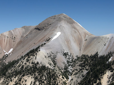
Attached is a picture we took on the peak at 11,400. You can see the snow field on the right which is the normal route up.Looking at it with binoculars you could see that it was about a thousand feet long and looking at the peak itself the Ridge in the middle is open but near the top is an area with small cliffs and very steep headwalls eliminating that approach. The peak itself is made up of broken shale much like scree but looks like gravel from a distance.This makes climbing up it very dangerous especially with a slip of any kind. The other side of the snow field is also steep the same as the view you see in the picture. That was it for us knowing without the proper equipment safety was priority one. We did hike farther and down to the pass between Belknap and the 11,400 peak. The road continues on for about another 2 miles to the climb start but we had had enough knowing we had to go back over all the passes from earlier in the day. We did have to scramble over a snowfield where the road was somewhere under it. Peg slipped and slid a little ways but no big rocks to hit and was fine. The snowfield was about 200 yards long and the same width.We had to climb down part of it to get off the 11,400 peak. That was proof that we did the right thing by not going up to the snowfield on Belknap.
Regrets Not a one, we really enjoyed the hike so much that disapointment never entered our minds,it was just too beautiful seeing all the views everytime we came to a turn in the road. After getting back up to the pass at 11,500 it was all down hill with sweeping views all the way back to the gate and car.
Whether we go back again or not I have pictures of Belknap of my own ,1 of which will be mounted in a frame and displayed in the tower for all to see, that there really is another Belknap just a trifle bigger than ours.
After thinking about it we MAY return and try again. Now that we know how to get in etc. We may just drive to Big John Flat and approach and talk to a few of what appears to be hundreds of ATVers camped there and offer to pay to have a couple of them taxi us in to the start.Piece of cake then")
The rest of the trip was us just being Tourists, We decided to stay south as reports of weather in the mid west as Hotter than parts of the south. We came from I-70 across Missourie and Kansas so a different return looked better.
We stopped in Capital Reef and Mesa Verda national parks, both a nice experience and educational to boot, no too much hiking. high heat but not reasonable,camping too was comfortable compared to tother parts of the country.
A stop at the Natural Bridges Nat.Monument was interesting and fun.
Driving down into Southern Colorado and Northern New mexico was a treat with many miles of nice scenery and an area we had not been in.Seeing parts of Lake Powell and the surrounding desert near Blanding was a highlight as well.So much to see and experience along the way.
Worked our way to Texas via Cortez,Durango Col. to Las Vegas (NM) Tucumcari NM to Amarillo Tex. Pegs home State. Heat warnings in Oklahoma sent us south again so that gave us a trip to Palo Duro Canyon State Park. We had heard that it is a nice place to see and it was. No hiking here this time of year,all trailheads have thermometers and with temps showing 130+ in the sun and 108 in the shade was not appealing.We did get out a few times but quickly back to the air conditioning of the car and a nice long visit in the visitors center.This is a great place to visit in the spring and espec.in the fall.We must return.Check out the Long Horn Steers at the entrance of the Park,They wrere huge about twice as big as our big Oxen we have at our Fairs with horns measuring at least 8-10 feet wide.
Of course being in Texas there is a town named GRAHAM Texas, so we had to visit it on our way to see Lubbock.
Peg had not been to Lubbock. Graham is a nice town and an Oasis in the desert worth the visit and a stop in the Local Dairy Queen. The Dairy Queen sign is the officail stop sign of Texas I have been told and Every town has one.Probably more than one.
Continued North West to Sherman and on to Paris. Had to stop in Paris for breakfast and Walmart for supplies. Paris is where Pegs Family lived for many years.We traveled every other year to visit for the past 35 years but now the family has passed on,still nice memories of our visits.
On to interstate 30 across Arkansas,Tenn. and into Va. one of our favorite states along I-81. Most of the time driving home we drive parts of the Blue ridge Parkway and the Sky-Line drive to enjoy this most beautiful area and to camp along the way.This trip was no exception.
A stop in Harrisburg Penn. to visit the National Civil War Museum was a must stop. We have wanted to understand and know more about the Civil War, so this was a most enjoyable and educational experience for this NH Boy and his Texas Gal. Making for better understanding of this dark point in our Heritage. We got to shake hands with Old Honest Abe Lincoln up close and personal. Recommended to all.
So there you have the whole story.Hope you enjoyed it and made it to the end. Peg is going to put the pictures on the Picasa web site with a link so that those interested can see the entire trip in pictures.
Hal and Peg.
Here is the Link to the pictures of the trip. Hal/Peg
https://picasaweb.google.com/halpeg76/BelknapUtah2011?authuser=0&feat=directlink
Regardless we had a really good trip even though we could not get to the top AGAIN.The details follow.
We were told that the Beaver and Tushar Range area had a record level of snow late in the spring and followed that up with heavy spring rains causing damage to the Trails and roads in the vicinity we needed to access the Mt..
We had a feeling approaching the Tushar Mts. from I-70 that we may have problems due to snow fields high up that we could see ,and we were not disappointed.
We did have good luck, in that the Paiute Trail (ATV), that goes almost the entire state of Utah was open for 4 miles (Big John Flat) of the approx.13 miles to get to the starting point at a little over 10,000 feet altitude. We did manage to get 6 miles in by car (passed the flat) but that was it,after just being able to get over 3 small snow drifts and a small drainage with only about 3''s of water.Immediately after and just as we were reaching Timberline a gate closing the road further stopped us.
On with our packs and off we went following a good road but not passable to even ATVs.A rather deep wash out 2 feet wide and 4 feet deep and many snow drifts with mud from the melting snow was the reason for the closure.
We knew then we probably would not make it with another 5 miles of hiking and another 1,500 feet of climbing on Belknap itself, so we resigned ourselves on just getting as far as possible and enjoying the incredible beauty around us that is Utah.The road was great hiking with hundreds of switch backs and only a steep pitch here and there and mostly bare of snow other than a few drifts to climb over. We reached a pass at 11,500 feet and (the highest point of a road in Utah according to Summit Post), where we got our first real look at Belknap and what was ahead of us.The road went downhill and back up a couple of times all the time switchbacking.We commented that we have to remember that we have to hike back up all these downhills on the way back. We also noticed that the altitude was starting to slow us down but we were comfortable so we continued on.The temps. were in the high 40s and a glorious Blue sky all day,perfect for hiking. Soon we could get a good look at Belknap after scrambling up a peak to 11,400 feet.
There we saw a snowfield that was to be our route up to the summit and without an ice axe nor crampons (certainly not expected in late July according to the locals) made it a little touchy for us. The snow was soft about 2 inches, then very hard packed ,making steps difficult.
Attached is a picture we took on the peak at 11,400. You can see the snow field on the right which is the normal route up.Looking at it with binoculars you could see that it was about a thousand feet long and looking at the peak itself the Ridge in the middle is open but near the top is an area with small cliffs and very steep headwalls eliminating that approach. The peak itself is made up of broken shale much like scree but looks like gravel from a distance.This makes climbing up it very dangerous especially with a slip of any kind. The other side of the snow field is also steep the same as the view you see in the picture. That was it for us knowing without the proper equipment safety was priority one. We did hike farther and down to the pass between Belknap and the 11,400 peak. The road continues on for about another 2 miles to the climb start but we had had enough knowing we had to go back over all the passes from earlier in the day. We did have to scramble over a snowfield where the road was somewhere under it. Peg slipped and slid a little ways but no big rocks to hit and was fine. The snowfield was about 200 yards long and the same width.We had to climb down part of it to get off the 11,400 peak. That was proof that we did the right thing by not going up to the snowfield on Belknap.
Regrets Not a one, we really enjoyed the hike so much that disapointment never entered our minds,it was just too beautiful seeing all the views everytime we came to a turn in the road. After getting back up to the pass at 11,500 it was all down hill with sweeping views all the way back to the gate and car.
Whether we go back again or not I have pictures of Belknap of my own ,1 of which will be mounted in a frame and displayed in the tower for all to see, that there really is another Belknap just a trifle bigger than ours.
After thinking about it we MAY return and try again. Now that we know how to get in etc. We may just drive to Big John Flat and approach and talk to a few of what appears to be hundreds of ATVers camped there and offer to pay to have a couple of them taxi us in to the start.Piece of cake then
The rest of the trip was us just being Tourists, We decided to stay south as reports of weather in the mid west as Hotter than parts of the south. We came from I-70 across Missourie and Kansas so a different return looked better.
We stopped in Capital Reef and Mesa Verda national parks, both a nice experience and educational to boot, no too much hiking. high heat but not reasonable,camping too was comfortable compared to tother parts of the country.
A stop at the Natural Bridges Nat.Monument was interesting and fun.
Driving down into Southern Colorado and Northern New mexico was a treat with many miles of nice scenery and an area we had not been in.Seeing parts of Lake Powell and the surrounding desert near Blanding was a highlight as well.So much to see and experience along the way.
Worked our way to Texas via Cortez,Durango Col. to Las Vegas (NM) Tucumcari NM to Amarillo Tex. Pegs home State. Heat warnings in Oklahoma sent us south again so that gave us a trip to Palo Duro Canyon State Park. We had heard that it is a nice place to see and it was. No hiking here this time of year,all trailheads have thermometers and with temps showing 130+ in the sun and 108 in the shade was not appealing.We did get out a few times but quickly back to the air conditioning of the car and a nice long visit in the visitors center.This is a great place to visit in the spring and espec.in the fall.We must return.Check out the Long Horn Steers at the entrance of the Park,They wrere huge about twice as big as our big Oxen we have at our Fairs with horns measuring at least 8-10 feet wide.
Of course being in Texas there is a town named GRAHAM Texas, so we had to visit it on our way to see Lubbock.
Peg had not been to Lubbock. Graham is a nice town and an Oasis in the desert worth the visit and a stop in the Local Dairy Queen. The Dairy Queen sign is the officail stop sign of Texas I have been told and Every town has one.Probably more than one.
Continued North West to Sherman and on to Paris. Had to stop in Paris for breakfast and Walmart for supplies. Paris is where Pegs Family lived for many years.We traveled every other year to visit for the past 35 years but now the family has passed on,still nice memories of our visits.
On to interstate 30 across Arkansas,Tenn. and into Va. one of our favorite states along I-81. Most of the time driving home we drive parts of the Blue ridge Parkway and the Sky-Line drive to enjoy this most beautiful area and to camp along the way.This trip was no exception.
A stop in Harrisburg Penn. to visit the National Civil War Museum was a must stop. We have wanted to understand and know more about the Civil War, so this was a most enjoyable and educational experience for this NH Boy and his Texas Gal. Making for better understanding of this dark point in our Heritage. We got to shake hands with Old Honest Abe Lincoln up close and personal. Recommended to all.
So there you have the whole story.Hope you enjoyed it and made it to the end. Peg is going to put the pictures on the Picasa web site with a link so that those interested can see the entire trip in pictures.
Hal and Peg.
Here is the Link to the pictures of the trip. Hal/Peg
https://picasaweb.google.com/halpeg76/BelknapUtah2011?authuser=0&feat=directlink