1HappyHiker
Well-known member
Within about a 2 week period, I've posted separate hikes to: Madison Gulf area; Mt. Guyot; North & South Twin. In between those posted hikes, I've done a number of other local & miscellaneous hikes, including the one I did yesterday (30-June). Although this place was brand new to me, I'm certain that there are many folks on this Forum who have done it. I'm talking about the Tunnel Brook Trail.
The trail runs through the deep valley between Mt. Moosilauke and Mt. Clough. And speaking of Mt. Clough, I don't know why it amazed me, but nonetheless I was surprised when I first learned that the pronunciation of this mountain rhymes with words like "rough" or "enough". Anyway, it was also a bit surprising to read in Steve Smith's book (Ponds & Lakes of the White Mountains) that up until the 1920s there was an automobile route through this notch which served to connect the Benton/Easton area with the Glencliff/Warren area. With all the ponds and bogs that are now present here, you'd expect that the road was closed due to flooding from beaver activity. But apparently, landslides were the reason that this roadway was closed and never reopened.
I did this hike on a whim and on a day when I had only a few hours available to hike. I started my trek at the northern end of the trail. If you've ever hiked the Tunnel Brook Trail and/or looked at a trail map, then you know that your trek takes you along the shoreline of the chain of beaver ponds in this valley. If you were to follow the trail all the way to its southern end, you'd find yourself in the Glencliff area in close proximity to the trailhead for the Blueberry Mountain Trail, and within a few tenths of a mile from the Glencliff Trail to Moosilauke.
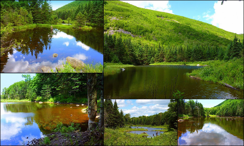
Since my time was limited, I certainly didn't hike all the way to Glencliff (and back!), nor did I even have time to visit all the ponds. However, I did see enough to know that I'll definitely be making a return visit to hike at least as far as Mud Pond which is the last pond in the chain. But, regarding the ponds that I did have time to visit, below is a collage of snapshots taken from various points along the way.
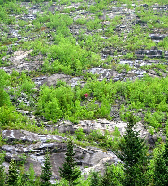
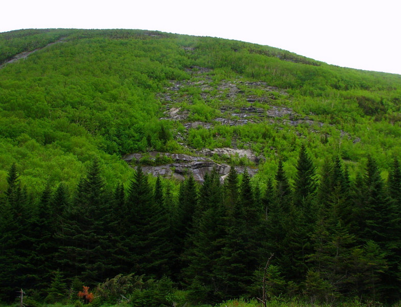
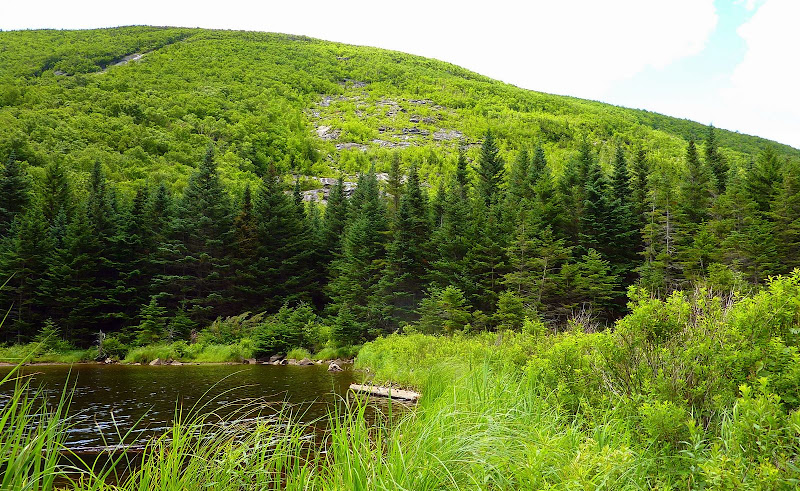
En route to the ponds, I took a short side trip to scamper up to a gravelly area just a short distance off the east side of the trail. From there, I was able to get a look at a small portion of the massive hulk of Mt. Clough (photo below).
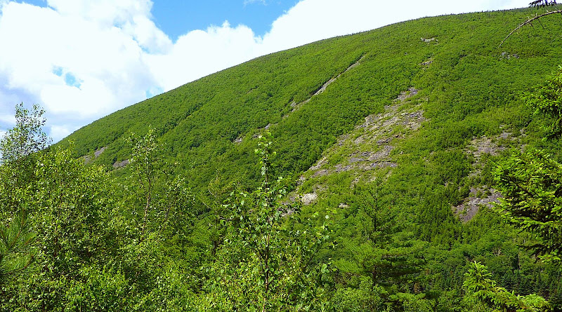
While looking at the landslide areas on the side of this mountain, I wondered how difficult it would be to get up on them to get a bird's eye view down to the ponds. Well, later in the hike I seized an opportunity to attempt a quick scramble up to one of those slide areas.
I saw a faint foot path over a beaver dam which led to the base of a slide on Mt. Clough. I was utterly shocked and amazed at how easy it was to get up onto the cliffy/ledgy areas of the slide! I'm not exaggerating. Within 15 minutes from the time I left Tunnel Brook Trail, I was far enough up on the slide to get the views in the 3 snapshots shown below.
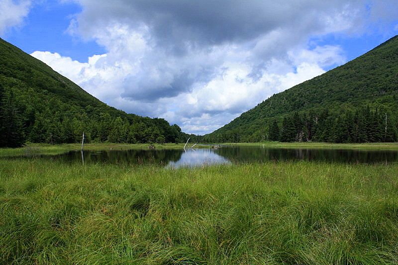
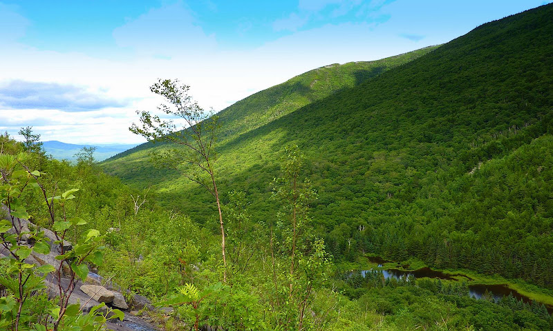
A few of the ponds in the chain
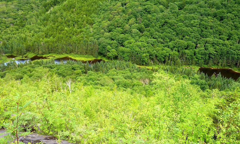
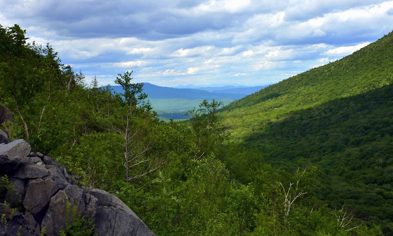
Looking northward from the slide
Another northward view with peaks in the Pilot Range on the distant horizon
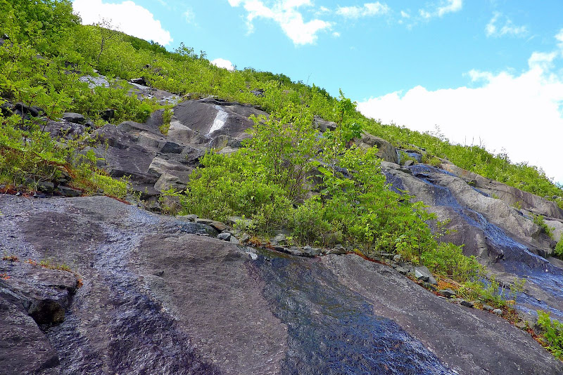
Although it was quite quick & easy to scamper a short distance up this slide on this particular day, I'm certain that it would be foolhardy to attempt this under wet and/or icy conditions. I think you'll see what I mean when you take a look at the photo below which was taken while climbing this rock-face!
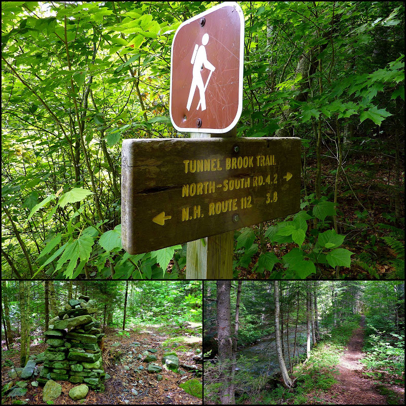
Besides being impressed with the picturesque ponds, and the view from the slide on Mt. Clough, I also enjoyed simply hiking on the Tunnel Brook Trail itself. The surrounding forest is very attractive, and the one stretch of trail that parallels Tunnel Brook is simply beautiful. Also, it was sort of cool to see the huge cairns that are located along one short segment of the trail. Some are nearly as big as the cairns found above tree-line on the Presidential Range. Below is a collage of some photos related to just the trail itself.
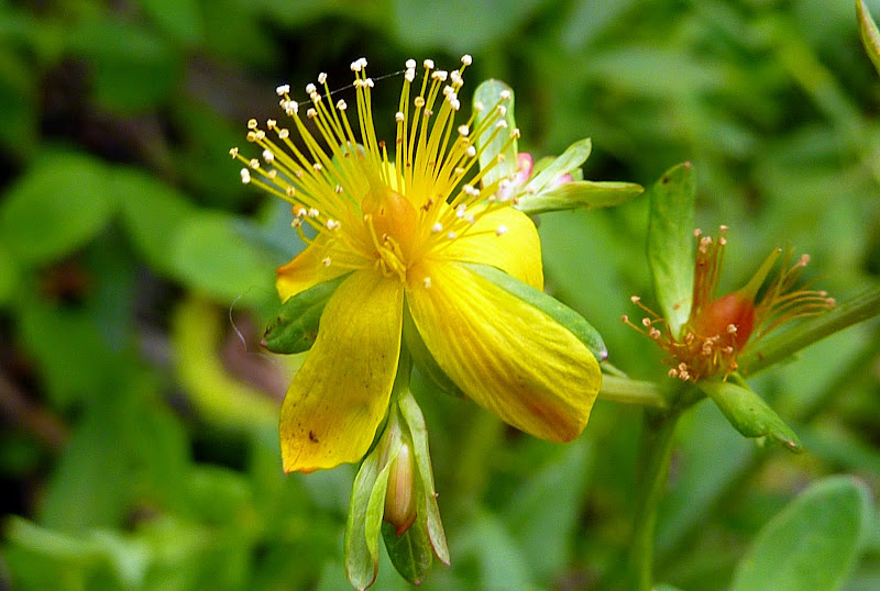
Probably I should also mention that there were quite a few wildflowers in bloom, particularly around the pond areas. There were the usual cast of characters for this time of year, but the one I particularly liked was the one shown below which I think is St. John's wort (please correct me if I'm wrong!).
Here's just one last side-note before ending this report. I've been to the summit of Mt. Clough by whacking off Long Pond Road. I'm just curious as to whether bushwhacking to Clough from the Tunnel Brook Trail is another route that's sometimes used??
Okay . . . enough already about this hike!! As I said near the beginning of this report, my time was limited on this particular day. However, I saw enough to convince me to make a return visit to completely explore all the ponds, and to scramble up some of the other slides on Mt. Clough.
If anyone has photos from their hikes into this area, please feel free to post them when replying to this thread. I'd love to see them!
1HappyHiker
The trail runs through the deep valley between Mt. Moosilauke and Mt. Clough. And speaking of Mt. Clough, I don't know why it amazed me, but nonetheless I was surprised when I first learned that the pronunciation of this mountain rhymes with words like "rough" or "enough". Anyway, it was also a bit surprising to read in Steve Smith's book (Ponds & Lakes of the White Mountains) that up until the 1920s there was an automobile route through this notch which served to connect the Benton/Easton area with the Glencliff/Warren area. With all the ponds and bogs that are now present here, you'd expect that the road was closed due to flooding from beaver activity. But apparently, landslides were the reason that this roadway was closed and never reopened.
I did this hike on a whim and on a day when I had only a few hours available to hike. I started my trek at the northern end of the trail. If you've ever hiked the Tunnel Brook Trail and/or looked at a trail map, then you know that your trek takes you along the shoreline of the chain of beaver ponds in this valley. If you were to follow the trail all the way to its southern end, you'd find yourself in the Glencliff area in close proximity to the trailhead for the Blueberry Mountain Trail, and within a few tenths of a mile from the Glencliff Trail to Moosilauke.
Since my time was limited, I certainly didn't hike all the way to Glencliff (and back!), nor did I even have time to visit all the ponds. However, I did see enough to know that I'll definitely be making a return visit to hike at least as far as Mud Pond which is the last pond in the chain. But, regarding the ponds that I did have time to visit, below is a collage of snapshots taken from various points along the way.
En route to the ponds, I took a short side trip to scamper up to a gravelly area just a short distance off the east side of the trail. From there, I was able to get a look at a small portion of the massive hulk of Mt. Clough (photo below).
While looking at the landslide areas on the side of this mountain, I wondered how difficult it would be to get up on them to get a bird's eye view down to the ponds. Well, later in the hike I seized an opportunity to attempt a quick scramble up to one of those slide areas.
I saw a faint foot path over a beaver dam which led to the base of a slide on Mt. Clough. I was utterly shocked and amazed at how easy it was to get up onto the cliffy/ledgy areas of the slide! I'm not exaggerating. Within 15 minutes from the time I left Tunnel Brook Trail, I was far enough up on the slide to get the views in the 3 snapshots shown below.
A few of the ponds in the chain
Looking northward from the slide
Another northward view with peaks in the Pilot Range on the distant horizon
Although it was quite quick & easy to scamper a short distance up this slide on this particular day, I'm certain that it would be foolhardy to attempt this under wet and/or icy conditions. I think you'll see what I mean when you take a look at the photo below which was taken while climbing this rock-face!
Besides being impressed with the picturesque ponds, and the view from the slide on Mt. Clough, I also enjoyed simply hiking on the Tunnel Brook Trail itself. The surrounding forest is very attractive, and the one stretch of trail that parallels Tunnel Brook is simply beautiful. Also, it was sort of cool to see the huge cairns that are located along one short segment of the trail. Some are nearly as big as the cairns found above tree-line on the Presidential Range. Below is a collage of some photos related to just the trail itself.
Probably I should also mention that there were quite a few wildflowers in bloom, particularly around the pond areas. There were the usual cast of characters for this time of year, but the one I particularly liked was the one shown below which I think is St. John's wort (please correct me if I'm wrong!).
Here's just one last side-note before ending this report. I've been to the summit of Mt. Clough by whacking off Long Pond Road. I'm just curious as to whether bushwhacking to Clough from the Tunnel Brook Trail is another route that's sometimes used??
Okay . . . enough already about this hike!! As I said near the beginning of this report, my time was limited on this particular day. However, I saw enough to convince me to make a return visit to completely explore all the ponds, and to scramble up some of the other slides on Mt. Clough.
If anyone has photos from their hikes into this area, please feel free to post them when replying to this thread. I'd love to see them!
1HappyHiker
Last edited:


")