Fisher Cat
New member
- Joined
- Jul 27, 2007
- Messages
- 789
- Reaction score
- 109
This section entails Bartlett-Conway & Mount Carrigain
BARTLETT-CONWAY
P 256-Mt Kearsage or Pequawket (you decide, it seems to have been a debate then)”Pequawket..about the year 1784 the mountain first appeared on the map under the name Kearsage. From that day to this it has been known by both names, but Kearsage has had local preference. Another fine mountain in Merrimac County had borne this name for many years prior to 1784. This resulted in confusion, and in 1915 the US Geographic Board adopted the name Pequawket for the northern mountain and Kearsage for the southern one. It seems best, for the purposes of this work,to use both names. Obviously more clarification begets the same results. A sidepoint: I personally prefer Pequawket. Lest we forget that during the F & I War the Massacre at Fort Henry (though not as substantial as that pictured in the 1992 version of Last of the Mohicans)disgruntled with the fact that they had been deprived of the spoils of a war they were fighting, several individual Natives attacked individually (as pictured in the movie) the militia column which was a signal to begin the general melee. Both British, French, and Native sources identified these warriors as members of the Pequawket/Penacook tribes. This attack had far-reaching consequences on the war and treaties of truce for its entire course, and into the American Revolution. So for better, or worse, one should recognize the historical consequences of NH’s Native American population.
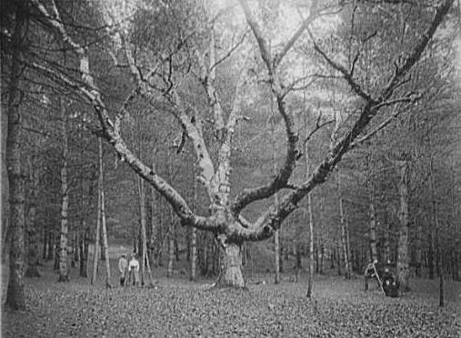
P 257 Intervale Path- this was a path maintained by the Intervale Improvement Society. I could find no info on this group so if anyone knows, I’d be interested in hearing it. No mention of this path in recent guidebooks but it led to Mt Bartlett & Kearsage Village Path. In doing so “begins at Intervale RR Station, leads through the Cathedral Woods, and past the Wizard Birch.”
P 259 Shingle Pond Trail-maintained by the Chatham Trails Association, again couldn’t find any background, but the trail seems to have been replaced by today’s Weeks Brook Trail under WMNF juridstiction.
P 260 & 261 The Green Hills of Conway- In 1936 these hills were Hurricane Mtn., Black Cap (maintained by the aforementioned IIS), Sunset Hill, Middle Mtn., and Peaked Mtn. Today in 2008 they are classified as Hurricane Mtn, Black Cap,Peaked Mtn,Middle Mtn., Cranmore Mtn, and Rattlesnake Mtn. Today this area, in part, belongs to the Green Hills Preserve, 2822 ac. A reservation, the book notes, that we are indebted to thanks to the generosity of the Anna B. Stearns Foundation, which in 1990 was maintained by the Nature Conservancy. Thank you Anna! In 1936 any trails here were quite indistinct as the following description shows for Peaked Mtn “in ascending it is well to note carefully the point where the two trails diverge or cross, asa there may not be signs, and in descending one would naturally follow the wrong trail. The route…to the foot of the ledges, above which it is marked only by inconspicuous cairns, and an almost indiscernible foot-way.” Alfred Hammond’s farm is also mentioned in this as a waypoint.
P 264 Thompson’s Falls Trail- “marked with green and white arrows, the trail starts at the ruins of the Echo Lake Schoolhouse, now almost completely disappeared.” The site of the schoolhouse “is reached from No. Conway by the road branching W from NH 16, just N of the Sunset Inn. After crossing the Saco take the L fork, and follow it till it joins the Echo Lake Road, on which the opposite side the ruins will be found.” I’ve always been fascinated by these old schoolhouses, existing as it seems, in the middle of nowhere. There was one down the road where we lived on Valley Road, just before our blueberry pickin’ fields.
P 268-Humphrey Ledge “ an old road, now much overgrown, leaves highway at a small wooden building marked with a sign “Pitman’s Arch”, 1 1/2m. N of the Lucy Farm on the highway W of the Saco.” The 2007 guidebook mentions that this was once a toll path, perhaps explaining the small wooden building mentioned in the 1936 book, the 2007 book mentions that this old path is completely overgrown.
P 268-White Horse Ledge via Diana’s Baths notes the path “is marked by arrows and black paint on the rocks.” I know painting on rocks for markers is now forbidden, and has been for awhile, but all the same, black seems like a weird color to use in the first place.
P 272-Passaconaway Mountain Club was, at the time, responsible for several paths. The Brunel Trail which ascended Mt Tremont via Owl Cliff, the Trail to Birch Hill which diverged from the Brunel Trail midway between the Sawyer Pond Trail and Rob Brook,and the Trail to Green’s Cliff which diverged L from Sawyer Pond Trail a short distance S of the Birch Hill Trail. This Trail to Green’s Cliff seems to have only been in the planning stages and I don’t know if it was ever started or finished.
P 275 Mount Silver Spring- Another name controversy. “This mountain, formerly known as Bartlett haystack, has also been called Revelation.” The 2007 book says this same mountain now known “as Bartlett Haystack, formerly Silver Spring.”
P 278-Pleasant Mtn, ME (2007 ft.) “because of its isolated position, this mountain in Denmark, ME, commands an unusual view. There is a steel observation tower of the MFD on the summit, where also the AMC owns a reservation of 20 ac., given by Mr. Winthrop Coffin in 1908. The trail (Old Carraige Road) begins at a bar-way just N of Mt Aqua Cottage.” Anyone know what a bar-way was? The East Tower Trail was used, when descending “care should be taken to follow the cairns and blazes, as there are many random paths made by berry-pickers.”
THE MOUNT CARRIGAIN REGION
Intro states “ At present much of the area is closed to all trampers and other sections are closed to those who do not have special permission to enter.” Footnote reads:”On account of the extensive areas of softwood slash, which constitute at present a dangerous forest fire hazard, in the north Fork, Cedar Brook, and Crystal Brook drainages of the Pemigewasset east Branch, the WMNF has closed to public entry(from April 1 to Novenber 1)the middle portion of the East Branch watershed from Camp 17 trestle (2 1/2m. above Franconia Branch)eastward beyond Stillwater to Shoal Pond Trail, Carrigain Notch Trail and a detour around Stillwater to be cut early in 1936 to replace for the present the S section of the exisiting Shoal Pond Trail and the W portion of Carrigain Notch Trail. This closed area includes the watersheds of Cedar Brook, Black Brook, Crystal Brook, and North Fork. Trails affected by this closure are the Bondcliff, Desolation and Thoreau Falls Trails;portions of Shoal Pond and Carrigain Notch trails; as well as the logging RR main line and spurs in this area. In addition to this absolute closed area, travel up the East Branch Valley from Lincoln is prohibited, except by permit which may be obtained from the Woodstock Ranger District office at Plymouth or the Parker-Young Company at Lincoln. Three National Forest patrolmen are on duty to enforce the above regulations.”
P 282-Signal ridge Trail notes “trail diverges L about 2.2m from Livermore Trail and soon passes Carrigain Brook. It then ascends in gradual slopes, and in 15 min. from the fork,reaches the ruins of Camp 5, a good camp-site near a brook.”
P 283- Desolation Trail “trail leaves the Carrigain Notch Trail at the site of Camp 20…higher up a broad road, with telephone wire intact in Sept 1932, is followed for some distance..at the top of this road the trail bears E into virgin timber.” The 2007 book mentions these same poles.
Finally, I want to relate a great incident. The main binding of this book is falling apart. By accident it slipped off my car seat the other day and I was upset it may have broken. It didn’t, but the fall revealed a narrow-seamed pocket I had never seen before, with something blue inside. I pulled it out only to find 3 cards, one of which is available for viewing with the attachment below. Perhaps the Ancient and Honorable Order of Squirrels was a forerunner of Smokey the Bear. The other 2 cards showed the young lad also visited the tower on Carrigain on May 30, 1940, and the tower on Middle Sister on May 28, 1940. The ranger on Carrigain was Robert Payne, the one on Middle Sister was Maurice Savard. Long live the Ancient and Honorable Order of Squirrels.
Hope you have enjoyed!
BARTLETT-CONWAY
P 256-Mt Kearsage or Pequawket (you decide, it seems to have been a debate then)”Pequawket..about the year 1784 the mountain first appeared on the map under the name Kearsage. From that day to this it has been known by both names, but Kearsage has had local preference. Another fine mountain in Merrimac County had borne this name for many years prior to 1784. This resulted in confusion, and in 1915 the US Geographic Board adopted the name Pequawket for the northern mountain and Kearsage for the southern one. It seems best, for the purposes of this work,to use both names. Obviously more clarification begets the same results. A sidepoint: I personally prefer Pequawket. Lest we forget that during the F & I War the Massacre at Fort Henry (though not as substantial as that pictured in the 1992 version of Last of the Mohicans)disgruntled with the fact that they had been deprived of the spoils of a war they were fighting, several individual Natives attacked individually (as pictured in the movie) the militia column which was a signal to begin the general melee. Both British, French, and Native sources identified these warriors as members of the Pequawket/Penacook tribes. This attack had far-reaching consequences on the war and treaties of truce for its entire course, and into the American Revolution. So for better, or worse, one should recognize the historical consequences of NH’s Native American population.
P 257 Intervale Path- this was a path maintained by the Intervale Improvement Society. I could find no info on this group so if anyone knows, I’d be interested in hearing it. No mention of this path in recent guidebooks but it led to Mt Bartlett & Kearsage Village Path. In doing so “begins at Intervale RR Station, leads through the Cathedral Woods, and past the Wizard Birch.”
P 259 Shingle Pond Trail-maintained by the Chatham Trails Association, again couldn’t find any background, but the trail seems to have been replaced by today’s Weeks Brook Trail under WMNF juridstiction.
P 260 & 261 The Green Hills of Conway- In 1936 these hills were Hurricane Mtn., Black Cap (maintained by the aforementioned IIS), Sunset Hill, Middle Mtn., and Peaked Mtn. Today in 2008 they are classified as Hurricane Mtn, Black Cap,Peaked Mtn,Middle Mtn., Cranmore Mtn, and Rattlesnake Mtn. Today this area, in part, belongs to the Green Hills Preserve, 2822 ac. A reservation, the book notes, that we are indebted to thanks to the generosity of the Anna B. Stearns Foundation, which in 1990 was maintained by the Nature Conservancy. Thank you Anna! In 1936 any trails here were quite indistinct as the following description shows for Peaked Mtn “in ascending it is well to note carefully the point where the two trails diverge or cross, asa there may not be signs, and in descending one would naturally follow the wrong trail. The route…to the foot of the ledges, above which it is marked only by inconspicuous cairns, and an almost indiscernible foot-way.” Alfred Hammond’s farm is also mentioned in this as a waypoint.
P 264 Thompson’s Falls Trail- “marked with green and white arrows, the trail starts at the ruins of the Echo Lake Schoolhouse, now almost completely disappeared.” The site of the schoolhouse “is reached from No. Conway by the road branching W from NH 16, just N of the Sunset Inn. After crossing the Saco take the L fork, and follow it till it joins the Echo Lake Road, on which the opposite side the ruins will be found.” I’ve always been fascinated by these old schoolhouses, existing as it seems, in the middle of nowhere. There was one down the road where we lived on Valley Road, just before our blueberry pickin’ fields.
P 268-Humphrey Ledge “ an old road, now much overgrown, leaves highway at a small wooden building marked with a sign “Pitman’s Arch”, 1 1/2m. N of the Lucy Farm on the highway W of the Saco.” The 2007 guidebook mentions that this was once a toll path, perhaps explaining the small wooden building mentioned in the 1936 book, the 2007 book mentions that this old path is completely overgrown.
P 268-White Horse Ledge via Diana’s Baths notes the path “is marked by arrows and black paint on the rocks.” I know painting on rocks for markers is now forbidden, and has been for awhile, but all the same, black seems like a weird color to use in the first place.
P 272-Passaconaway Mountain Club was, at the time, responsible for several paths. The Brunel Trail which ascended Mt Tremont via Owl Cliff, the Trail to Birch Hill which diverged from the Brunel Trail midway between the Sawyer Pond Trail and Rob Brook,and the Trail to Green’s Cliff which diverged L from Sawyer Pond Trail a short distance S of the Birch Hill Trail. This Trail to Green’s Cliff seems to have only been in the planning stages and I don’t know if it was ever started or finished.
P 275 Mount Silver Spring- Another name controversy. “This mountain, formerly known as Bartlett haystack, has also been called Revelation.” The 2007 book says this same mountain now known “as Bartlett Haystack, formerly Silver Spring.”
P 278-Pleasant Mtn, ME (2007 ft.) “because of its isolated position, this mountain in Denmark, ME, commands an unusual view. There is a steel observation tower of the MFD on the summit, where also the AMC owns a reservation of 20 ac., given by Mr. Winthrop Coffin in 1908. The trail (Old Carraige Road) begins at a bar-way just N of Mt Aqua Cottage.” Anyone know what a bar-way was? The East Tower Trail was used, when descending “care should be taken to follow the cairns and blazes, as there are many random paths made by berry-pickers.”
THE MOUNT CARRIGAIN REGION
Intro states “ At present much of the area is closed to all trampers and other sections are closed to those who do not have special permission to enter.” Footnote reads:”On account of the extensive areas of softwood slash, which constitute at present a dangerous forest fire hazard, in the north Fork, Cedar Brook, and Crystal Brook drainages of the Pemigewasset east Branch, the WMNF has closed to public entry(from April 1 to Novenber 1)the middle portion of the East Branch watershed from Camp 17 trestle (2 1/2m. above Franconia Branch)eastward beyond Stillwater to Shoal Pond Trail, Carrigain Notch Trail and a detour around Stillwater to be cut early in 1936 to replace for the present the S section of the exisiting Shoal Pond Trail and the W portion of Carrigain Notch Trail. This closed area includes the watersheds of Cedar Brook, Black Brook, Crystal Brook, and North Fork. Trails affected by this closure are the Bondcliff, Desolation and Thoreau Falls Trails;portions of Shoal Pond and Carrigain Notch trails; as well as the logging RR main line and spurs in this area. In addition to this absolute closed area, travel up the East Branch Valley from Lincoln is prohibited, except by permit which may be obtained from the Woodstock Ranger District office at Plymouth or the Parker-Young Company at Lincoln. Three National Forest patrolmen are on duty to enforce the above regulations.”
P 282-Signal ridge Trail notes “trail diverges L about 2.2m from Livermore Trail and soon passes Carrigain Brook. It then ascends in gradual slopes, and in 15 min. from the fork,reaches the ruins of Camp 5, a good camp-site near a brook.”
P 283- Desolation Trail “trail leaves the Carrigain Notch Trail at the site of Camp 20…higher up a broad road, with telephone wire intact in Sept 1932, is followed for some distance..at the top of this road the trail bears E into virgin timber.” The 2007 book mentions these same poles.
Finally, I want to relate a great incident. The main binding of this book is falling apart. By accident it slipped off my car seat the other day and I was upset it may have broken. It didn’t, but the fall revealed a narrow-seamed pocket I had never seen before, with something blue inside. I pulled it out only to find 3 cards, one of which is available for viewing with the attachment below. Perhaps the Ancient and Honorable Order of Squirrels was a forerunner of Smokey the Bear. The other 2 cards showed the young lad also visited the tower on Carrigain on May 30, 1940, and the tower on Middle Sister on May 28, 1940. The ranger on Carrigain was Robert Payne, the one on Middle Sister was Maurice Savard. Long live the Ancient and Honorable Order of Squirrels.
Hope you have enjoyed!