
Becca M
Active member
11/26/11 – Bushwhack Mt Clough and random trail stuff in the Glencliff area….
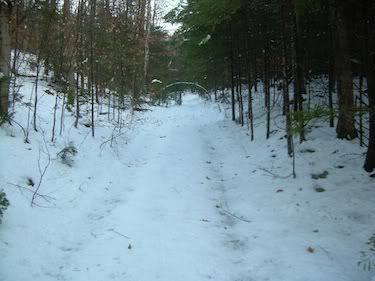
Looked like a good day to do something different so I headed for Mt Clough, my first time there. I decided I would go from the south end of Tunnel Brook Trail for no particular reason. I was afraid of the road to the trailhead: though it wasn’t gated, it looked icy in the early morning. So, I parked at the Glenclif Trail parking area – my first time parking there and NOT hiking Moosilauke – it felt WEIRD!!!! I headed down the road, took the first right, and then the next right onto Tunnel Brook Trail. No footprints ahead of me!
Tunnel Brook Trail – a fine coating of snow/ice and little evidence of anything other than deer.
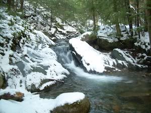
Although I brought traction and snowshoes, they all stayed in/on my pack. The snow really didn’t get much deeper than 3-4” all day at all elevations. I was happy to finally travel the lower portion of Tunnel Brook Trail since I had bushwhacked east near the dam and had never completed the actual trail until today. I found a pretty waterfall:
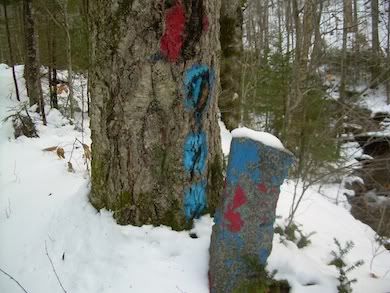
Tunnel Brook looked very skiable even without a lot of snow. I didn’t bother skiing since I would be bushwhacking and didn’t want to hike in my ski boots, especially if I wasn’t certain I’d be using snowshoes. A little further up, I found a colorful boundary marking:
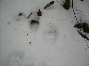
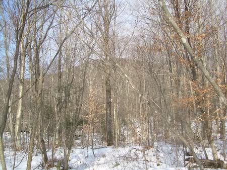
Eventually, I found a good line to get the north/south ridge up to Clough. I know Clough is considered an easy bushwhack because it’s pretty open. I’d give it a “3” rating on the 1-10 bushwhack difficulty rating scale (10 being the worst, like Scar Ridge). There were a few scrappy sections, a few rocky/mossy steeps and occasional boot-sucking mud pits. But, it was pretty pleasant. I also followed the wisdom of the wildlife— along with moose tracks, the bear tracks seemed to show the best corridors:
As I was hiking, I thought about how much I’d like to thank people who’ve taught me most of what I know about bushwhacking: mostly Forestgnome & Hiker Ed…. I only used a map (no compass or GPS tho I carried them) and just followed the terrain. This is a great bushwhack for exploring and working on confidence-building. Plus, there’s the beautiful shoulder of Moosilauke to guide you…. AWESOME!!!!
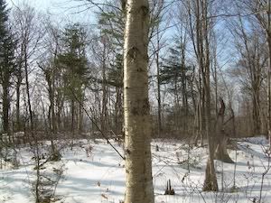
After the summit, which was pretty obvious, I just followed my tracks down – half the time of the ascent. On the lower knolls, here are some the typical views. Looking back up north to Clough:
Looking back south:
Once back at Tunnel Brook Trail, travel was a little slippery in the melting snow. Finally I saw someone as I got close to the dam area, and then came across a large group having a wiener roast… strange since one had a “PETA” shirt on – maybe the wieners were vegan? Looked like fun!!!!
Back on the road, I took a right to scope out the south end of the Blueberry Mtn Trail – still closed for logging. But, I also noticed a rather ominous-looking bear dog truck (wish that were a beer truck!!!) parked at that trailhead. I decided without proper hunter orange I probably should get out of there, especially since I felt a little pudgy after eating so much food on Thanksgiving!!!
So I continued to the Town Line Trail and decided to take it. I was a little worried because I remember Ed mentioning a water crossing that would be difficult…. Ugh… I didn’t read the trail guide so I wasn’t sure if it was at the north or south end….
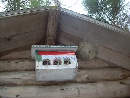
Town Line Trail is VERY pleasant. The Jeffers Brook Shelter is fairly standard except for the bird/insect house on the gable end:
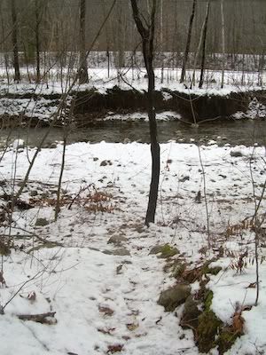
After that, there are a few tree-filled views of Webster Slide Mtn and a long descent to the Oliverian Notch. Eventually, I came to the dreaded water crossing at the south end, just before the road:
It didn’t look too terrible until I completely soaked both feet. On the way back, I took the logging bridge just down the road… I don’t think it was kosher but I didn’t want to double-dip!!!
All in all, an awesome day out there!!!!
Looked like a good day to do something different so I headed for Mt Clough, my first time there. I decided I would go from the south end of Tunnel Brook Trail for no particular reason. I was afraid of the road to the trailhead: though it wasn’t gated, it looked icy in the early morning. So, I parked at the Glenclif Trail parking area – my first time parking there and NOT hiking Moosilauke – it felt WEIRD!!!! I headed down the road, took the first right, and then the next right onto Tunnel Brook Trail. No footprints ahead of me!
Tunnel Brook Trail – a fine coating of snow/ice and little evidence of anything other than deer.
Although I brought traction and snowshoes, they all stayed in/on my pack. The snow really didn’t get much deeper than 3-4” all day at all elevations. I was happy to finally travel the lower portion of Tunnel Brook Trail since I had bushwhacked east near the dam and had never completed the actual trail until today. I found a pretty waterfall:
Tunnel Brook looked very skiable even without a lot of snow. I didn’t bother skiing since I would be bushwhacking and didn’t want to hike in my ski boots, especially if I wasn’t certain I’d be using snowshoes. A little further up, I found a colorful boundary marking:
Eventually, I found a good line to get the north/south ridge up to Clough. I know Clough is considered an easy bushwhack because it’s pretty open. I’d give it a “3” rating on the 1-10 bushwhack difficulty rating scale (10 being the worst, like Scar Ridge). There were a few scrappy sections, a few rocky/mossy steeps and occasional boot-sucking mud pits. But, it was pretty pleasant. I also followed the wisdom of the wildlife— along with moose tracks, the bear tracks seemed to show the best corridors:
As I was hiking, I thought about how much I’d like to thank people who’ve taught me most of what I know about bushwhacking: mostly Forestgnome & Hiker Ed…. I only used a map (no compass or GPS tho I carried them) and just followed the terrain. This is a great bushwhack for exploring and working on confidence-building. Plus, there’s the beautiful shoulder of Moosilauke to guide you…. AWESOME!!!!
After the summit, which was pretty obvious, I just followed my tracks down – half the time of the ascent. On the lower knolls, here are some the typical views. Looking back up north to Clough:
Looking back south:
Once back at Tunnel Brook Trail, travel was a little slippery in the melting snow. Finally I saw someone as I got close to the dam area, and then came across a large group having a wiener roast… strange since one had a “PETA” shirt on – maybe the wieners were vegan? Looked like fun!!!!
Back on the road, I took a right to scope out the south end of the Blueberry Mtn Trail – still closed for logging. But, I also noticed a rather ominous-looking bear dog truck (wish that were a beer truck!!!) parked at that trailhead. I decided without proper hunter orange I probably should get out of there, especially since I felt a little pudgy after eating so much food on Thanksgiving!!!
So I continued to the Town Line Trail and decided to take it. I was a little worried because I remember Ed mentioning a water crossing that would be difficult…. Ugh… I didn’t read the trail guide so I wasn’t sure if it was at the north or south end….
Town Line Trail is VERY pleasant. The Jeffers Brook Shelter is fairly standard except for the bird/insect house on the gable end:
After that, there are a few tree-filled views of Webster Slide Mtn and a long descent to the Oliverian Notch. Eventually, I came to the dreaded water crossing at the south end, just before the road:
It didn’t look too terrible until I completely soaked both feet. On the way back, I took the logging bridge just down the road… I don’t think it was kosher but I didn’t want to double-dip!!!
All in all, an awesome day out there!!!!
") Awesome TR and nice going! Love the bear track photos
Awesome TR and nice going! Love the bear track photos